Overview
|
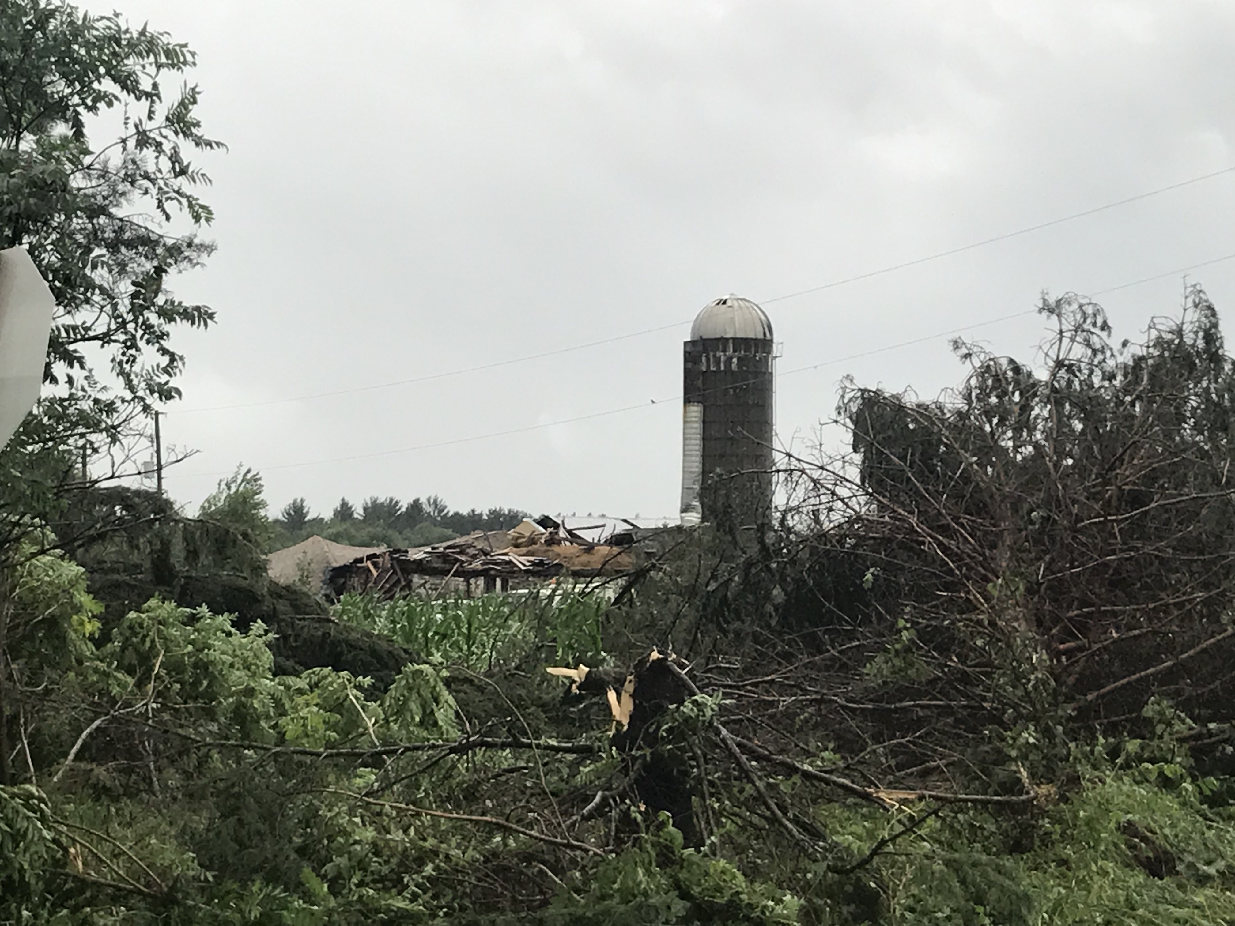
A line of severe thunderstorms moved across much of central, north central, and eastern WI during the evening hours on July 19, 2019. Widespread tree and power line damage was reported from central Wisconsin into the Fox Valley and lake shore. WPS reported over 50,000 outages at the height of the storm. The worst damage was associated with a "macroburst," a large downburst of straight-line winds that affected a large swath from Pelican Lake in Oneida County, southeast through Langlade and Oconto counties. Hundreds of thousands of trees were snapped or uprooted, resulting in damage to dozens of homes and cottages. The damage path was about 60 miles long and up to 10 miles wide at times. Winds were at least 100 mph in the hardest hit areas near Lily in northeast Langlade County. Please see the tabs below for more information.
|
 |
Tornadoes:
|
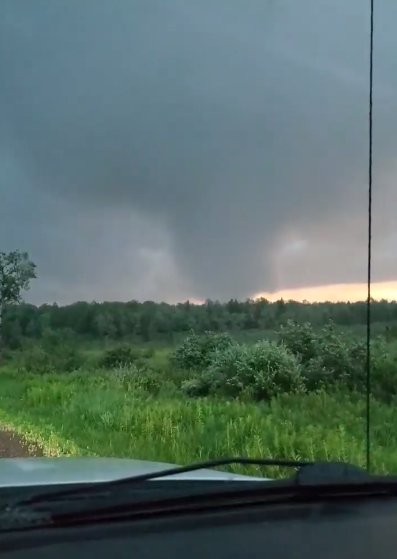
Tripoli
Track Map
|
||||||||||||||||||
|
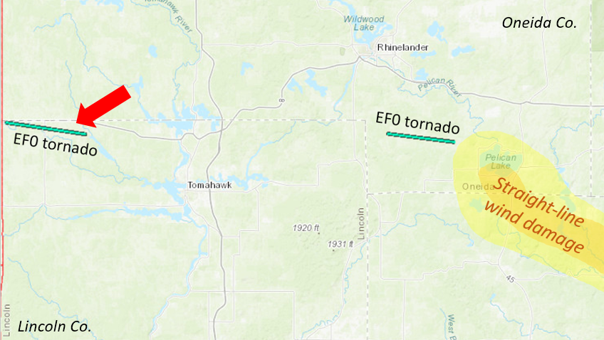
West of Pelican Lake
Track Map
|
||||||||||||||||||
|
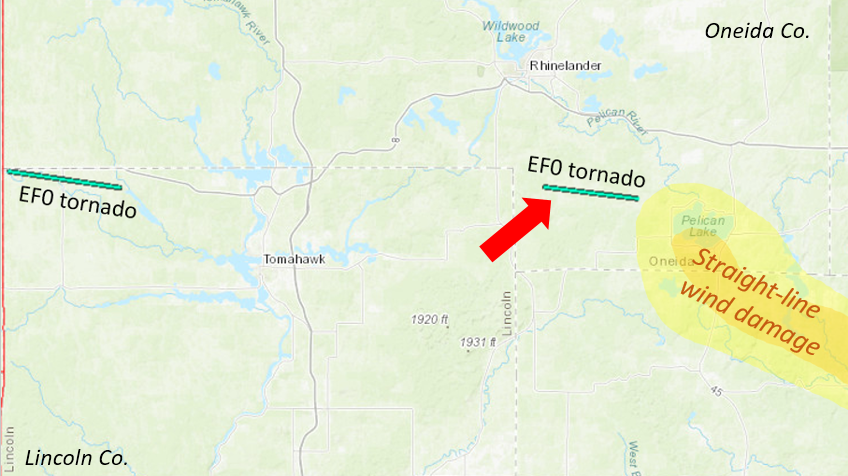
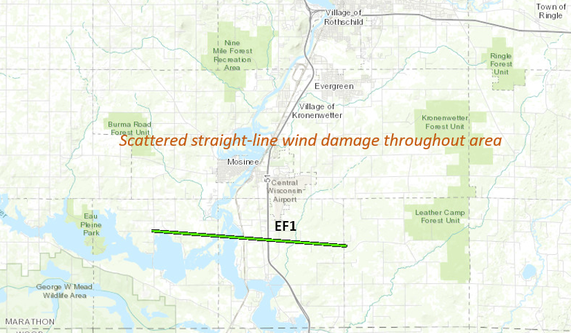
Knowlton
Track Map
|
||||||||||||||||||
The Enhanced Fujita (EF) Scale classifies tornadoes into the following categories:
| EF0 Weak 65-85 mph |
EF1 Moderate 86-110 mph |
EF2 Significant 111-135 mph |
EF3 Severe 136-165 mph |
EF4 Extreme 166-200 mph |
EF5 Catastrophic 200+ mph |
 |
|||||
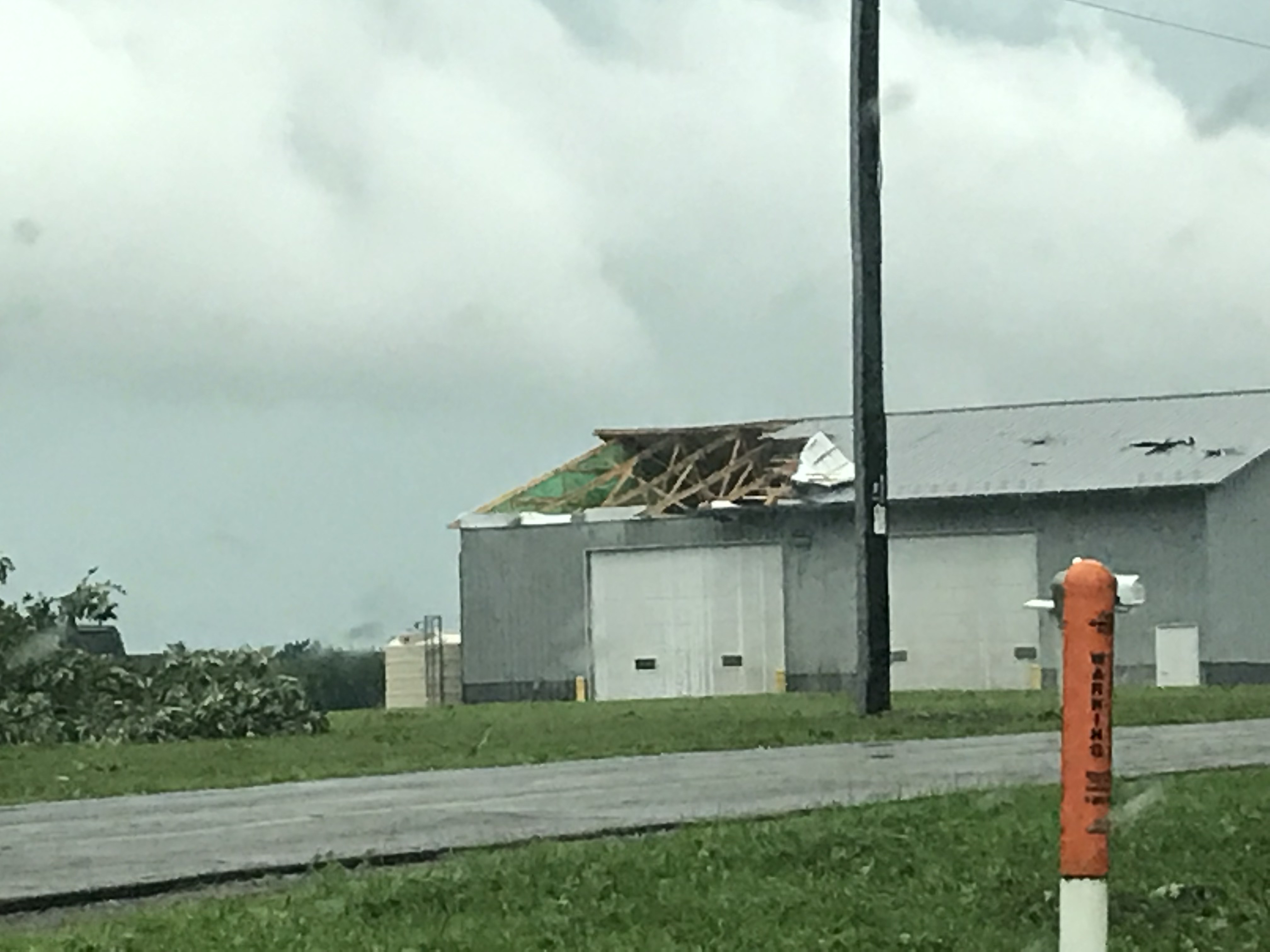
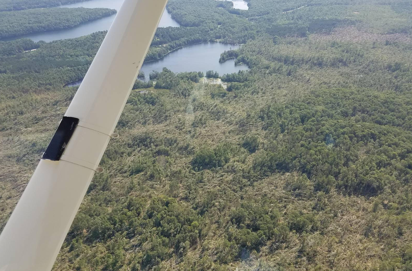
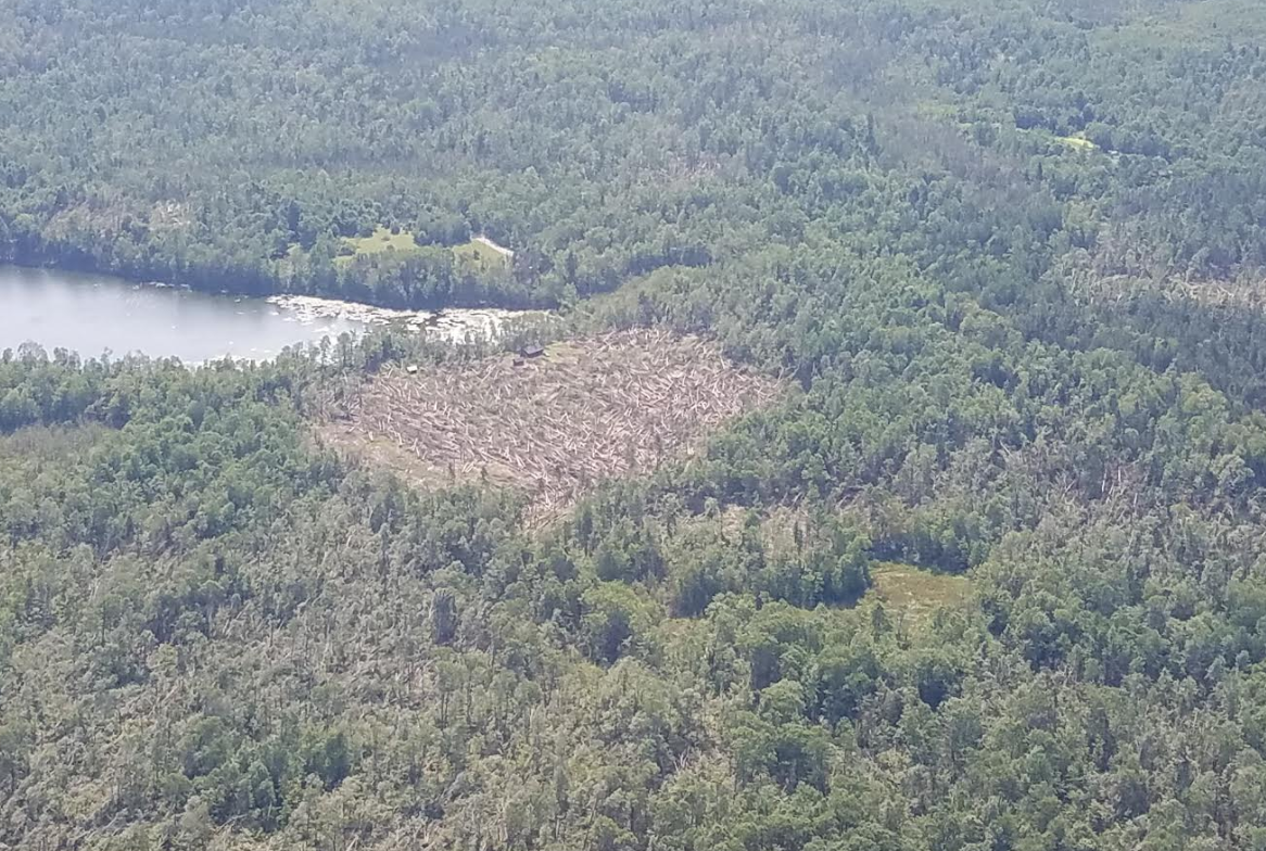
Straight-Line Winds:
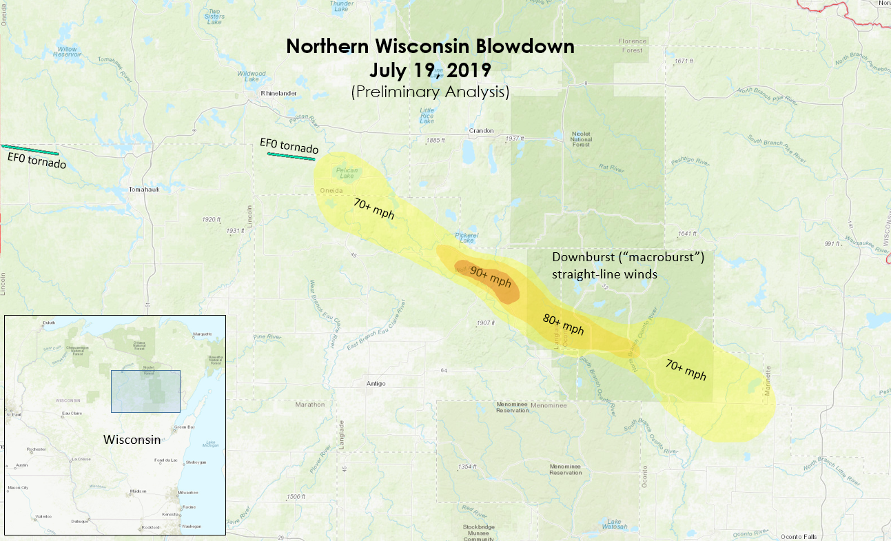 |
| Preliminary analysis of widespread, concentrated wind damage from aerial surveys. Wind speeds are estimated and will be refined as additional analysis continues. |
|
Downburst damage in southern Forest Co. |
Downburst damage in southern Forest Co. |
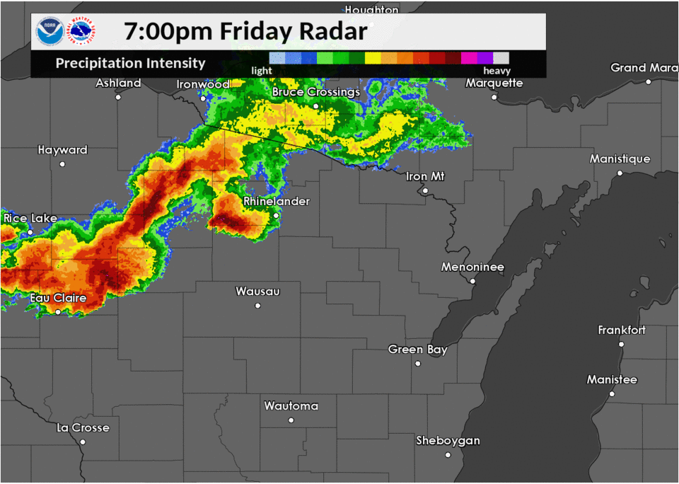
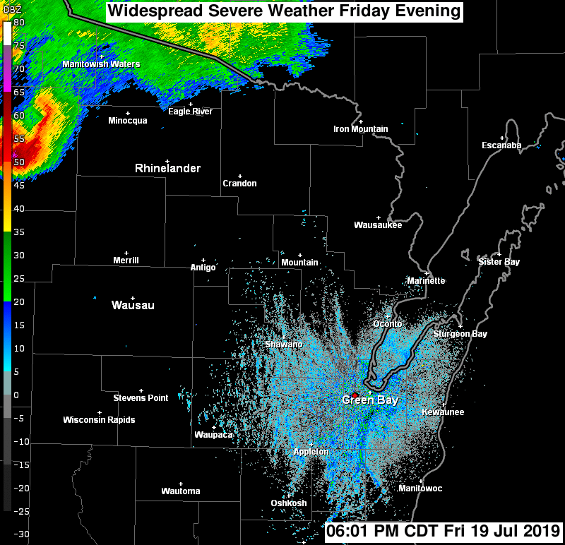
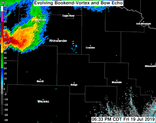
Radar:
 |
|||
| Radar Reflectivity from 6:00 PM to 11:50 PM July 19, 2019 |
|||
|
Radar Reflectivity (2-4 minute intervals including SAILS scans) from 6:33 PM to 9:31 PM July 19, 2019 |
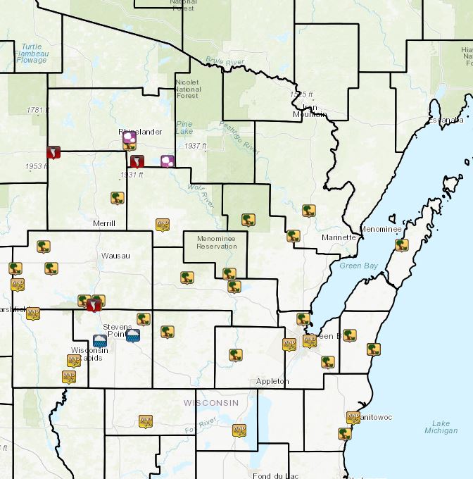
Preliminary Storm Reports
 |
|
| Storm reports from July 19 |
PRELIMINARY LOCAL STORM REPORT...SUMMARY
NATIONAL WEATHER SERVICE GREEN BAY WI
1232 AM CDT SAT JUL 20 2019

..TIME...   ...EVENT...      ...CITY LOCATION...     ...LAT.LON...
..DATE...   ....MAG....      ..COUNTY LOCATION..ST.. ...SOURCE....
            ..REMARKS..

0743 PM     HAIL             RHINELANDER             45.63N 89.41W
07/19/2019  M1.00 INCH       ONEIDA             WI   AMATEUR RADIO

0744 PM     HAIL             RHINELANDER             45.63N 89.41W
07/19/2019  E1.00 INCH       ONEIDA             WI   LAW ENFORCEMENT

            1 INCH HAIL AND LOCALIZED FLOODING IN CITY OF RHINELANDER
            REPORTED BY FIRE DEPARTMENT.

0744 PM     TSTM WND DMG     3 S RHINELANDER         45.59N 89.41W
07/19/2019                   ONEIDA             WI   TRAINED SPOTTER

            TREES DOWN. DELAYED REPORT. TIME ESTIMATED BY RADAR.

0747 PM     TSTM WND GST     4 N SPENCER             44.82N 90.28W
07/19/2019  M53.00 MPH       MARATHON           WI   TRAINED SPOTTER

0756 PM     TSTM WND DMG     GLEASON                 45.30N 89.50W
07/19/2019                   LINCOLN            WI   TRAINED SPOTTER

            TREE BRANCHES DOWN.

0800 PM     TSTM WND DMG     3 W EDGAR               44.91N 90.02W
07/19/2019                   MARATHON           WI   TRAINED SPOTTER

            WINDS ESTIMATED AT 65 MPH DESTROYED A 100 FOOT BY 60 FOOT
            WELL CONSTRUCTED POLE BARN THREE MILES NORTH OF HIGHWAY
            29 ON HIGHWAY M. TIME ESTIMATED.

0804 PM     TSTM WND DMG     ATHENS                  45.03N 90.08W
07/19/2019                   MARATHON           WI   LAW ENFORCEMENT

            POWERLINES DOWN IN ATHENS. MUCH OF THE VILLAGE IS WITHOUT
            POWER.

0805 PM     TSTM WND DMG     MARSHFIELD              44.66N 90.16W
07/19/2019                   WOOD               WI   911 CALL CENTER

            SEVERAL TREES AND POWERLINES DOWN THROUGHOUT THE COUNTY.


0805 PM     TSTM WND GST     MARSHFIELD              44.66N 90.16W
07/19/2019  M54.00 MPH       WOOD               WI   ASOS

0810 PM     TSTM WND DMG     COLBY                   44.91N 90.30W
07/19/2019                   MARATHON           WI   STORM CHASER

            TREES DOWN IN COLBY

0825 PM     TSTM WND GST     KNOWLTON                44.71N 89.68W
07/19/2019  M50.00 MPH       MARATHON           WI   LAW ENFORCEMENT

0825 PM     HAIL             PELICAN LAKE            45.50N 89.11W
07/19/2019  M1.25 INCH       ONEIDA             WI   TRAINED SPOTTER

            FOUR TREES DOWN THAT WERE 6 TO 8 INCHES IN DIAMETER.

0831 PM     TSTM WND DMG     ANTIGO                  45.15N 89.15W
07/19/2019                   LANGLADE           WI   LAW ENFORCEMENT

            TREES AND POWERLINES DOWN IN ANTIGO AND ACROSS THE ENTIRE
            COUNTY.

0845 PM     TSTM WND DMG     BOWLER                  44.86N 88.96W
07/19/2019                   SHAWANO            WI   911 CALL CENTER

            VERY WIDESPREAD TREE AND POWERLINE DAMAGE THROUGHOUT THE
            COUNTY. ALSO DISPATCH REPORTED A TREE ON A BUILDING AND A
            CAR WITHIN THE COUNTY.

0847 PM     TSTM WND DMG     KESHENA                 44.88N 88.63W
07/19/2019                   MENOMINEE          WI   911 CALL CENTER

            WIDSPREAD POWERLINE AND TREE DAMAGE. NO FLOODING
            OBSERVED.

0850 PM     TSTM WND DMG     ROSHOLT                 44.63N 89.30W
07/19/2019                   PORTAGE            WI   911 CALL CENTER

            WIDESPREAD TREE AND POWERLINE DAMAGE. WORST DAMAGE ACROSS
            THE NORTHEASTERN PORTIONS OF THE COUNTY. MINOR FLOODING
            WAS OBSERVED UNDER OVERPASSES AND FLOODING WAS OBSERVED
            ALONG I39 AS THE STORM OCCURRED.

0859 PM     TSTM WND DMG     CRIVITZ                 45.23N 88.01W
07/19/2019                   MARINETTE          WI   TRAINED SPOTTER

            SEVERAL TREES DOWN. STILL COMING DOWN AT THE TIME OF THE
            CALL.

0900 PM     TSTM WND DMG     2 N SHAWANO             44.81N 88.59W
07/19/2019                   SHAWANO            WI   911 CALL CENTER

            VERY WIDESPREAD TREE AND POWERLINE DAMAGE THROUGHOUT THE
            COUNTY. ALSO DISPATCH REPORTED A TREE ON A BUILDING AND A
            CAR WITHIN THE COUNTY.

0907 PM     TSTM WND DMG     5 SW MOSINEE            44.73N 89.76W
07/19/2019                   MARATHON           WI   AMATEUR RADIO

            HIGHWAY O FOUR MILES SOUTH OF MOON IMPASSABLE DUE TO
            FALLEN TREES

0908 PM     TSTM WND DMG     MOUNTAIN                45.18N 88.48W
07/19/2019                   OCONTO             WI   TRAINED SPOTTER

            NUMEROUS TREES DOWN IN THE MOUNTAIN AREA.

0912 PM     TSTM WND DMG     2 NE KNOWLTON           44.73N 89.65W
07/19/2019                   MARATHON           WI   AMATEUR RADIO

            TREES DOWN ON HIGHWAY X NORTH OF LOCKER ROAD. ROAD
            IMPASSABLE.

0914 PM     TSTM WND DMG     MOUNTAIN                45.18N 88.48W
07/19/2019                   OCONTO             WI   TRAINED SPOTTER

            TREES DOWN IN MOUNTAIN.

0915 PM     TSTM WND GST     NEKOOSA                 44.31N 89.88W
07/19/2019  E60.00 MPH       WOOD               WI   TRAINED SPOTTER

            SEVERAL SMALL TREE BRANCHES DOWN.

0915 PM     TSTM WND DMG     5 W POUND               45.09N 88.13W
07/19/2019                   OCONTO             WI   TRAINED SPOTTER

            MANY TREES DOWN ON HIGHWAY 64 BETWEEN POUND AND MOUNTAIN


0922 PM     HEAVY RAIN       2 SE POLONIA            44.54N 89.38W
07/19/2019  M1.20 INCH       PORTAGE            WI   PUBLIC

0926 PM     TSTM WND DMG     WISCONSIN RAPIDS        44.40N 89.84W
07/19/2019                   WOOD               WI   911 CALL CENTER

            SEVERAL TREES AND POWERLINES DOWN THROUGHOUT THE COUNTY.

0926 PM     TSTM WND DMG     SUAMICO                 44.63N 88.05W
07/19/2019                   BROWN              WI   PUBLIC

            LARGE TREE LIMB DOWN. REPORT FROM SOCIAL MEDIA. TIME
            ESTIMATED BY RADAR.

0926 PM     NON-TSTM WND GST WISCONSIN RAPIDS        44.40N 89.84W
07/19/2019  M50.00 MPH       WOOD               WI   ASOS

0927 PM     TSTM WND GST     HOBART                  44.49N 88.16W
07/19/2019  E50.00 MPH       BROWN              WI   NWS EMPLOYEE

            WIND GUSTING BETWEEN 40-50 MPH

0930 PM     TSTM WND DMG     4 N IOLA                44.56N 89.11W
07/19/2019                   WAUPACA            WI   TRAINED SPOTTER

            SEVERAL TREES DOWN. WINDS ESTIMATED AT 60 MPH. RAINFALL
            TOTAL OF 1.26 INCHES.

0932 PM     TSTM WND GST     GREEN BAY               44.51N 88.00W
07/19/2019  M50.00 MPH       BROWN              WI   ASOS

0940 PM     TSTM WND DMG     LUXEMBURG               44.54N 87.69W
07/19/2019                   KEWAUNEE           WI   911 CALL CENTER

            WIDEPSREAD TREE DAMAGE THROUGHOUT THE COUNTY. SPORADIC
            POWER OUTAGES REPORTED.

0944 PM     TSTM WND GST     GREEN BAY               44.51N 88.00W
07/19/2019  M51.00 MPH       BROWN              WI   ASOS

0945 PM     TSTM WND DMG     GREEN BAY               44.51N 88.00W
07/19/2019                   BROWN              WI   LAW ENFORCEMENT

            SEVERAL TREES DOWN IN THE GREEN BAY AREA. A FEW TREES ARE
            BLOCKING ROADS.

0952 PM     HAIL             GREEN BAY               44.51N 88.00W
07/19/2019  E0.50 INCH       BROWN              WI   AMATEUR RADIO

0954 PM     TSTM WND DMG     KEWAUNEE                44.46N 87.50W
07/19/2019                   KEWAUNEE           WI   911 CALL CENTER

            WIDESPREAD TREE DAMAGE THROUGHOUT THE COUNTY. SPORADIC
            POWER OUTAGES REPORTED.

0954 PM     HEAVY RAIN       4 W STEVENS POINT       44.51N 89.64W
07/19/2019  M1.77 INCH       PORTAGE            WI   PUBLIC

            ONE HOUR TOTAL. STILL RAINING.

0957 PM     TSTM WND DMG     WAUTOMA                 44.06N 89.28W
07/19/2019                   WAUSHARA           WI   911 CALL CENTER

            A FEW TREES DOWN THROUGHOUT THE COUNTY. NO FLOODING
            REPORTED.

0957 PM     TSTM WND GST     WAUTOMA                 44.06N 89.28W
07/19/2019  M46.00 MPH       WAUSHARA           WI   AWOS

1000 PM     TSTM WND GST     KEWAUNEE                44.46N 87.50W
07/19/2019  M48.00 MPH       KEWAUNEE           WI   C-MAN STATION

            GUST AT THE KEWAUNEE MARINE SITE.

1013 PM     TSTM WND GST     OSHKOSH                 44.01N 88.55W
07/19/2019  M52.00 MPH       WINNEBAGO          WI   ASOS

1022 PM     TSTM WND GST     MANITOWOC               44.08N 87.66W
07/19/2019  M46.00 MPH       MANITOWOC          WI   AWOS

1025 PM     TSTM WND DMG     NEWTON                  43.99N 87.73W
07/19/2019                   MANITOWOC          WI   TRAINED SPOTTER

            SEVERAL TREES DOWN.

1030 PM     TSTM WND DMG     MANITOWOC               44.08N 87.66W
07/19/2019                   MANITOWOC          WI   EMERGENCY MNGR

            WIDESPREAD WIND DAMAGE THROUGHOUT MANITOWOC COUNTY.
            SEVERAL POWERLINES DOWN THROUGHOUT THE COUNTY.

1042 PM     TSTM WND DMG     EGG HARBOR              45.04N 87.28W
07/19/2019                   DOOR               WI   TRAINED SPOTTER

            TREES AND POWER LINES DOWN
 |
Media use of NWS Web News Stories is encouraged! Please acknowledge the NWS as the source of any news information accessed from this site. |
|


 Follow us on YouTube