A Preliminary Look at the Severe Thunderstorms that Produced Large Hail and Wind Damage Across Central and Eastern Wisconsin on 2 August 2015.
Severe thunderstorms with large hail and damaging straight-line winds affected parts of central and northeast Wisconsin during the afternoon of August 2, 2015. The most intense storms developed near a west-east orientated surface boundary that stretched from near Wausau to Green Bay by early afternoon (Figure 1). Surface convergence along the boundary helped to initiate and organize the storms.
|
Some of the first severe storms of the event developed just north of Green Bay, over parts of Oconto and Marinette counties producing large hail in excess of 3 inches in diameter (Figure 4). These storms were part of a larger line of storms that raced eastward across the Bay of Green Bay, eventually producing widespread damaging winds and power outages across much of Door County (Figure 3). Note the portion of the line in Figure 3 that appears to accelerate (or bow eastward) from near Egg Harbor to Jacksonport. This bowing line segment (bow echo) produced some of the strongest winds which caused widespread wind damage and power outages. Meanwhile, additional storms developed westward toward the Wausau area. These storms moved southeast during the late afternoon and produced large hail and damaging winds from Marathon and Wood counties eastward to Sheboygan County. Finally, interesting radar evolution was also noted as the storms moved into Sheboygan County shortly after 5 pm CDT (Figure 5). The radar animation in Figure 5 below shows how the storms further to the north generated a large organized thunderstorm outflow boundary (gust front) that raced southward across the Fox Valley. The gust front is indicated by the narrow line of weak radar returns (blue colors) racing southward. As this outflow intersected a separate area of storms moving out of Fond du Lac County, a compact bowing radar signature (an indication that this portion of the line is accelerating faster than the rest of the storms) developed over northwest Sheboygan County. This bowing line of storms may have been responsible for the swath of wind damge that was reported from Elkhart Lake to Plymouth. |
 |
| Oconto Co. - Suzi Runge Lagerquist |

Figure 1. Surface map around 1 pm CDT Sunday August 2. Solid lines are surface pressure. The red dashed line
denotes a wind-shift. Note how the winds shift from northwest to southwest across the boundary. This boundary helped to
initiate and organize the storms.
Figure 2. NWS Green Bay Doppler radar animation of the severe storm evolution during the afternoon of August 2, 2015.
The radar animation is for the period beginning at 130 pm CDT and ending at about 530 pm CDT.
Figure 3. A close-up radar animation of the storms that raced across the waters of Green Bay and Door County producing
widespread wind damage and power outages.
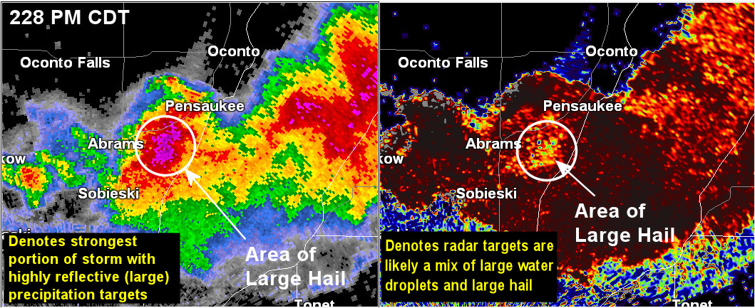
Figure 4. NWS Green Bay reflectivity image (left) and the dual polarization correlation coeficient (CC) product right at 228 pm CDT.
This particular storm produced 2 inch hail near Abrams a few minutes earlier (220 pm CDT) and produced 3.5 to 4.0 inch hail south of
Pensaukee near the time of this radar scan. The image on the right denotes the area where there was large hail mixed in with the
heavy rain.

Figure 5. Radar animation illustrating the interaction bewteen an area of storms and a thunderstorm outflow boundary
over Sheboygan County. This interaction may have been helped to intensify the storms over Sheboygan County enhancing the
wind damage there.
|
|
||||
|
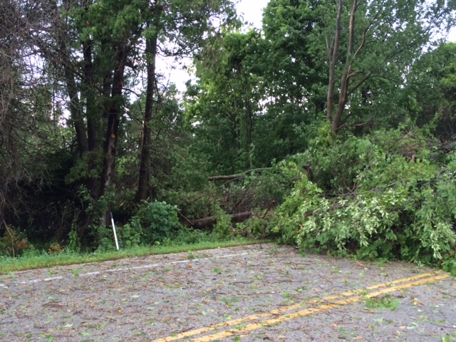
Figure 6. Hail greater than 3 inches in diameter was reported in Oconto County and widespread wind damage occurred in Door County.
Here is a preliminary list of storm reports from spotters and the public across the area after 1:30 pm:
..TIME...   ...EVENT...      ...CITY LOCATION...     ...LAT.LON...
..DATE...   ....MAG....      ..COUNTY LOCATION..ST.. ...SOURCE....
            ..REMARKS..

0149 PM     HAIL             2 W BEAVER              45.13N 88.05W
08/02/2015  E0.50 INCH       MARINETTE          WI   TRAINED SPOTTER

            SPOTTER DROVE THROUGH HAIL ON CTY HIGHWAY P

0149 PM     TSTM WND DMG     PESHTIGO                45.04N 87.75W
08/02/2015                   MARINETTE          WI   PUBLIC

            CALLER REPORTS SEVERAL TREES DOWN NEAR TOWN. TIME
            ESTIMATED FROM RADAR

0157 PM     HAIL             MARINETTE               45.09N 87.61W
08/02/2015  M0.25 INCH       MARINETTE          WI   TRAINED SPOTTER

            PEA SIZE HAIL AND SMALL TREE LIMBS DOWN

0205 PM     MARINE TSTM WIND 1 W SISTER BAY          45.18N 87.13W
08/02/2015  U0.00 MPH        DOOR               WI   COAST GUARD

            32 FOOT SAILBOAT CAPSIZED ONE MILE OFF SISTER BAY DUE TO
            HIGH WINDS AND WAVES. PASSANGERS WERE RESCUED BY COAST
            GUARD.

0215 PM     TSTM WND DMG     2 N JACKSONPORT         45.01N 87.18W
08/02/2015                   DOOR               WI   BROADCAST MEDIA

            TREES DOWN AND NO POWER. PICTURE FROM PUBLIC RELAYED BY
            WFRV-TV. TIME ESTIMATED BASED ON RADAR.

0215 PM     TSTM WND DMG     EGG HARBOR              45.04N 87.28W
08/02/2015                   DOOR               WI   AMATEUR RADIO

            TREES DOWN AND POWER OUT. ESTIMATED 60 TO 70 MPH WINDS.
            TIME BASED ON RADAR.

0215 PM     HAIL             OCONTO                  44.88N 87.88W
08/02/2015  E1.00 INCH       OCONTO             WI   PUBLIC

            HAIL FELL FOR A FEW MINUTES STARTING AROUND 215. NOT MANY
            STONES

0220 PM     HAIL             6 W MARSHFIELD          44.66N 90.28W
08/02/2015  E0.75 INCH       WOOD               WI   PUBLIC

            WINDS GUSTED TO AROUND 50 MPH AND DOWNED SMALL BRANCHES.

0221 PM     TSTM WND GST     STURGEON BAY            44.83N 87.38W
08/02/2015  E50.00 MPH       DOOR               WI   TRAINED SPOTTER

0221 PM     HAIL             ABRAMS                  44.78N 88.06W
08/02/2015  E4.00 INCH       OCONTO             WI   PUBLIC

0222 PM     TSTM WND DMG     MARINETTE               45.09N 87.61W
08/02/2015                   MARINETTE          WI   TRAINED SPOTTER

            SPOTTER/HAM OPERATOR RELAYED REPORTS OF SEVERAL TREES
            DOWN IN THE COUNTY WITH STORMS

0224 PM     HEAVY RAIN       ABRAMS                  44.78N 88.06W
08/02/2015  E1.75 INCH       OCONTO             WI   BROADCAST MEDIA

            ESTIMATED GOLF BALF SIZE HAIL BASED ON PHOTO RELAYED BY
            NBC26. TIME ESTIMATED BASED ON RADAR.
0229 PM     HAIL             5 NNE LITTLE SUAMICO    44.78N 87.95W
08/02/2015  E2.50 INCH       OCONTO             WI   PUBLIC

            NEAR OAK ORCHARD. REPORT VIA SOCIAL MEDIA. TIME ESTIMATED
            BY RADAR.
0233 PM     HAIL             3 ESE ABRAMS            44.76N 88.00W
08/02/2015  E4.00 INCH       OCONTO             WI   PUBLIC

            HAIL SIZE BASED ON PHOTO.
0253 PM     HAIL             SHAWANO                 44.78N 88.59W
08/02/2015  E0.50 INCH       SHAWANO            WI   TRAINED SPOTTER

            PEA TO DIME SIZE HAIL.

0300 PM     HAIL             2 SE SHAWANO            44.76N 88.56W
08/02/2015  E0.88 INCH       SHAWANO            WI   CO-OP OBSERVER

            NICKEL SIZE HAIL AND HEAVY RAIN.

0306 PM     HAIL             RUDOLPH                 44.50N 89.80W
08/02/2015  M2.00 INCH       WOOD               WI   BROADCAST MEDIA

            PICTURE AND REPORT RELAYED VIA WSAW-TV. TIME ESTIMATED BY
            RADAR.

0310 PM     HAIL             SHAWANO                 44.78N 88.59W
08/02/2015  M1.75 INCH       SHAWANO            WI   TRAINED SPOTTER

            AT SHAWANO HIGH SCHOOL.

0312 PM     HAIL             KRAKOW                  44.75N 88.25W
08/02/2015  E2.50 INCH       SHAWANO            WI   PUBLIC

            HAIL SIZE ESTIMATED BY PHOTO ON SOCIAL MEDIA. TIME
            ESTIMATED BY RADAR.

0318 PM     HAIL             1 E SUAMICO             44.63N 88.03W
08/02/2015  M1.75 INCH       BROWN              WI   LAW ENFORCEMENT

            BOATERS IN LONGTAIL POINT REPORTED GOLF BALL SIZE HAIL.
            TIME ESTIMATED BY RADAR.

0321 PM     HAIL             BIRON                   44.43N 89.78W
08/02/2015  E1.50 INCH       WOOD               WI   EMERGENCY MNGR

            REPORTED BY HAM OPERATOR AND RELAYED VIA COUNTY EOC

0328 PM     HAIL             PLOVER                  44.45N 89.53W
08/02/2015  M1.25 INCH       PORTAGE            WI   CO-OP OBSERVER

            MEASURED 41MPH WIND GUST. 0.10 INCH OF RAIN IN LAST 5
            MINUTES.

0333 PM     HAIL             STEVENS POINT           44.51N 89.56W
08/02/2015  M1.75 INCH       PORTAGE            WI   PUBLIC

            PHOTO SUBMITTED VIA SOCIAL MEDIA

0345 PM     LIGHTNING        SUAMICO                 44.63N 88.05W
08/02/2015                   BROWN              WI   LAW ENFORCEMENT

            HOUSE FIRE DUE TO LIGHTNING STRIKE.

0345 PM     HAIL             2 S ABRAMS              44.76N 88.05W
08/02/2015  E1.00 INCH       OCONTO             WI   PUBLIC

            PENNY TO QUARTER SIZE HAIL FELL NEAR ABRAMS. TIME IS
            APPROXIMATE.

0349 PM     HAIL             BANCROFT                44.31N 89.51W
08/02/2015  M1.00 INCH       PORTAGE            WI   TRAINED SPOTTER

            ESTIMATED 40MPH WINDS

0356 PM     HAIL             SEYMOUR                 44.51N 88.33W
08/02/2015  E0.50 INCH       OUTAGAMIE          WI   TRAINED SPOTTER

            PEA TO DIME SIZE HAIL AND HEAVY RAIN.

0401 PM     HAIL             KING                    44.33N 89.13W
08/02/2015  M1.00 INCH       WAUPACA            WI   TRAINED SPOTTER

            ESTIMATED 50MPH WIND GUSTS.

0407 PM     TSTM WND DMG     WILD ROSE               44.18N 89.25W
08/02/2015                   WAUSHARA           WI   TRAINED SPOTTER

            COUPLE OF MEDIUM SIZE TREES DOWN

0409 PM     HAIL             MOSINEE                 44.78N 89.69W
08/02/2015  E1.00 INCH       MARATHON           WI   TRAINED SPOTTER

            OBSERVED AT CENTRAL WISCONSIN AIRPORT

0430 PM     HAIL             3 S POY SIPPI           44.09N 89.00W
08/02/2015  M1.50 INCH       WAUSHARA           WI   EMERGENCY MNGR

            1 3/8 INCH HAIL MEASURED

0432 PM     HAIL             AURORAVILLE             44.04N 89.00W
08/02/2015  M1.75 INCH       WAUSHARA           WI   TRAINED SPOTTER

0441 PM     HAIL             8 SE OSHKOSH            43.93N 88.44W
08/02/2015  M1.00 INCH       WINNEBAGO          WI   TRAINED SPOTTER

            REPORT VIA SOCIAL MEDIA WITH PICTURE. TIME ESTIMATED BY
            RADAR.

0448 PM     TSTM WND GST     OSHKOSH                 44.01N 88.55W
08/02/2015  M50.00 MPH       WINNEBAGO          WI   ASOS

            MEASURED AT WITTMANN AIRPORT.

0453 PM     HAIL             4 N IOLA                44.56N 89.11W
08/02/2015  E1.00 INCH       WAUPACA            WI   TRAINED SPOTTER


 Follow us on YouTube