Tornado and Severe Weather Awareness Week
*TORNADO DRILL DAY*
The week of April 8-12, 2019, is Tornado and Severe Weather Awareness Week in Wisconsin. The National Weather Service in Wisconsin and Wisconsin Emergency Management are asking that everyone take time to go over their safety plans so that they will be ready when severe weather strikes. The time to prepare is before the storms hit.
Today, two tornado drills will be conducted. At 1 pm, a test Tornado Watch will be issued for all of Wisconsin and will be broadcast on NOAA Weather Radio. At 1:45 pm, the NWS Green Bay office will issue a test Tornado Warning. The test warning will be broadcast as a test on NOAA Weather Radio using the real Tornado Warning code. The afternoon drill will conclude at 2 pm. An evening drill (Warning only) will occur at 6:45 p.m.
|
|
The drill is usually held on Thursday, but severe weather postponed it to today.
|
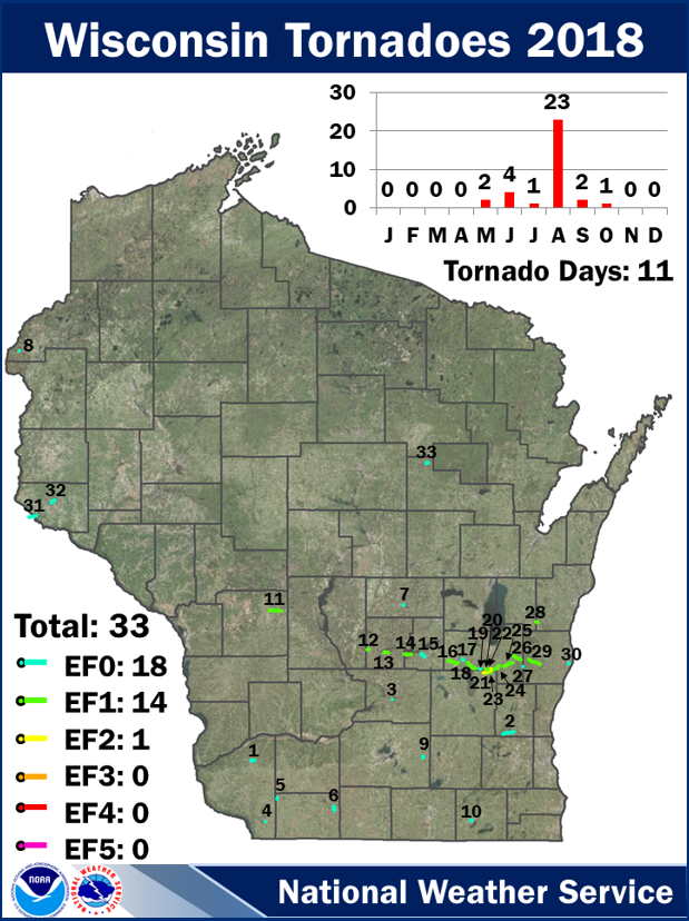
Wisconsin averages 23 tornadoes per year, with most tornadoes occurring from mid-afternoon into the early evening. The peak tornado season in Wisconsin is May through August, with June having the greatest number of tornadoes. A record-setting 62 tornadoes occurred in 2005. In 2012, Wisconsin had only 4 tornadoes. In 2018, there were 33 tornadoes reported in the state. The "average" Wisconsin tornado has a 7-10 minute duration, a path length of 4-6 miles, and a damage width of about 120 yards. Another hazard of the warm-season is powerful, straight-line thunderstorm winds that can exceed 60 mph and cause widespread damage. Severe Thunderstorm Warnings are issued for these wind events. Large hail is also a hazard with storms. Severe Thunderstorm Warnings are issued for storms with hail of at least 1" in diameter. |
 |
Join the Conversation!
Make sure to follow us on Twitter and Facebook to learn more about severe weather in north-central and northeast Wisconsin.
More Information to Help You Become Weather-Ready
Wireless Emergency Alerts - Wireless Emergency Alerts (WEA) send Tornado Warnings and Flash Flood Warnings to your cell phone. Click here to learn about WEA and how the alerts might impact how you receive a warning. Here is a PSA featuring a Flash Flood Warning and Wireless Emergency Alerts: Click here
The "Be A Force of Nature" website is located on the National Weather Service's Weather-Ready Nation page. There is a wealth of preparedness material on the page! Click here
Videos with information about what to do before, during, and after a tornado:
Get Weather-Ready: Before a Tornado
Get Weather-Ready: During a Tornado
Get Weather-Ready: After a Tornado


 Follow us on YouTube