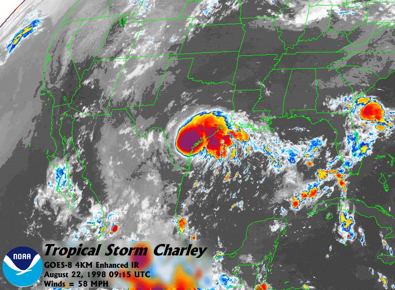
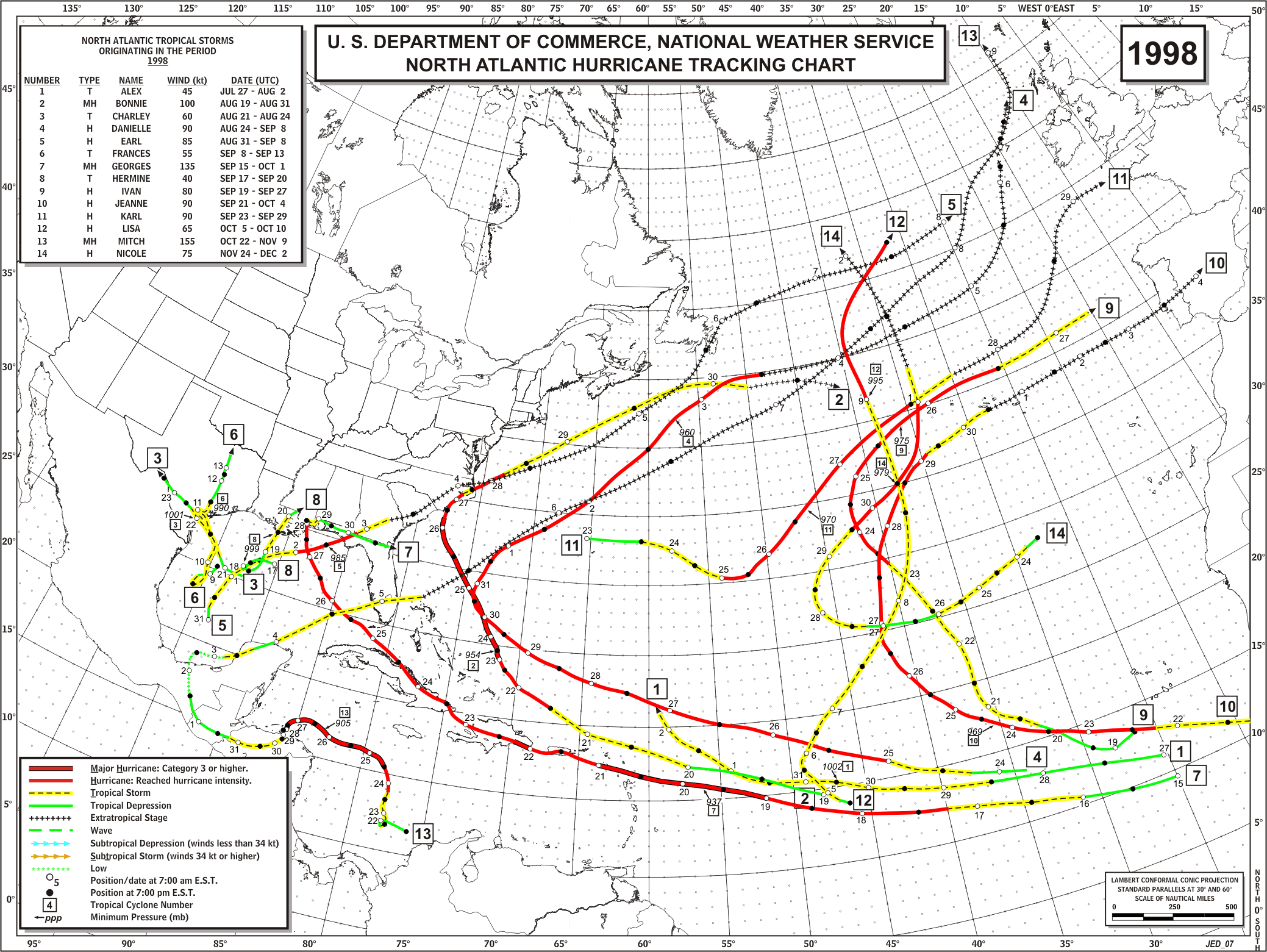
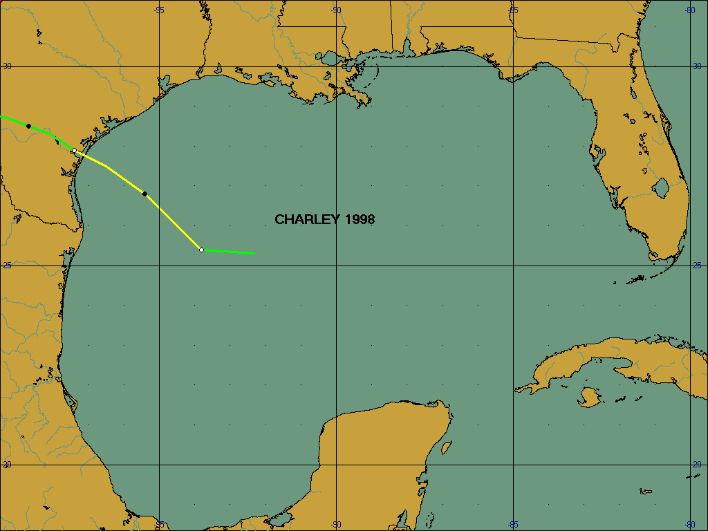
Charley developed from an area of low pressure that was tracked from the southeast Gulf of Mexico into the central Gulf. The system formed into a depression early on Aug. 21 centered about 275 miles off the south Texas coast. The system strengthened into a tropical storm later that same day. Charley reached its peak intensity of 70 mph - just short of hurricane status - shortly before moving inland on the middle Texas coast near Port Aransas on Aug. 22. After landfall, the surface circulation weakened to near dissipation but a slow moving circulation aloft persisted in the vicinity of the Del Rio, Texas area. This system generated flooding rains that were most devastating to that area on Aug. 23-24. Charley and his remnants claimed 21 lives - 12 in Texas (mainly in the Del Rio area) and 9 across the border in Ciudad Acuna, Mexico.
Damage from Charley was minimal across Southeast Texas. Beach erosion accounted for most of the damage estimates. Tides ran 2 to 3 feet above predicted astronomical levels. Most areas across Southeast Texas averaged 2 to 4 inches of rainfall; however, locations along the coast received 4 to 6 inches. An unofficial report of 9 inches was reported at the mouth of the San Bernard River in Brazoria County. The peak recorded wind gust of 69 mph was measured at the Colorado River Locks in Matagorda County. However, most locations across the coast had gusts less than 46 mph.
A track map of Charley can be found here.
More information on Charley is available in the National Hurricane Center's Tropical Cyclone Report.
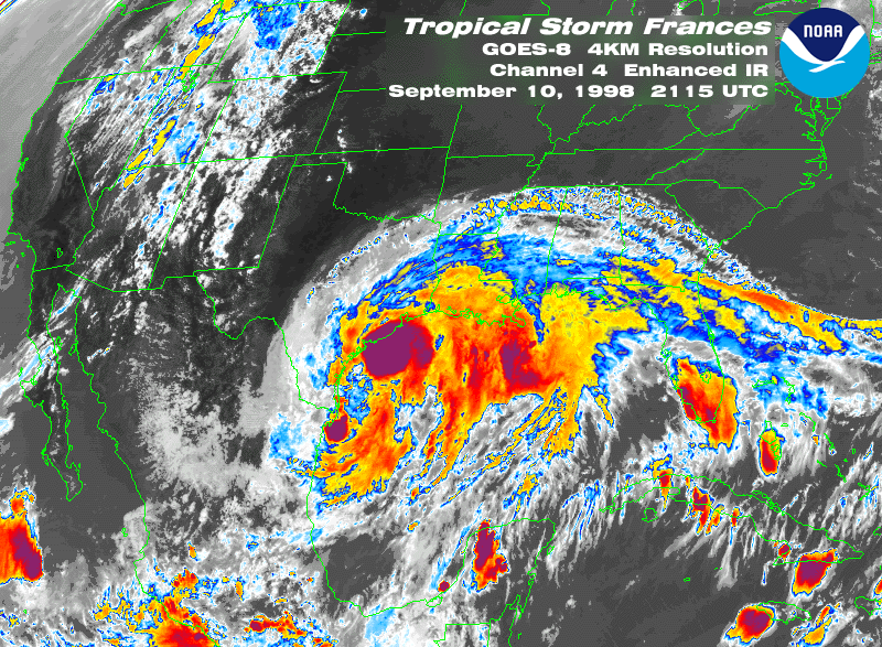
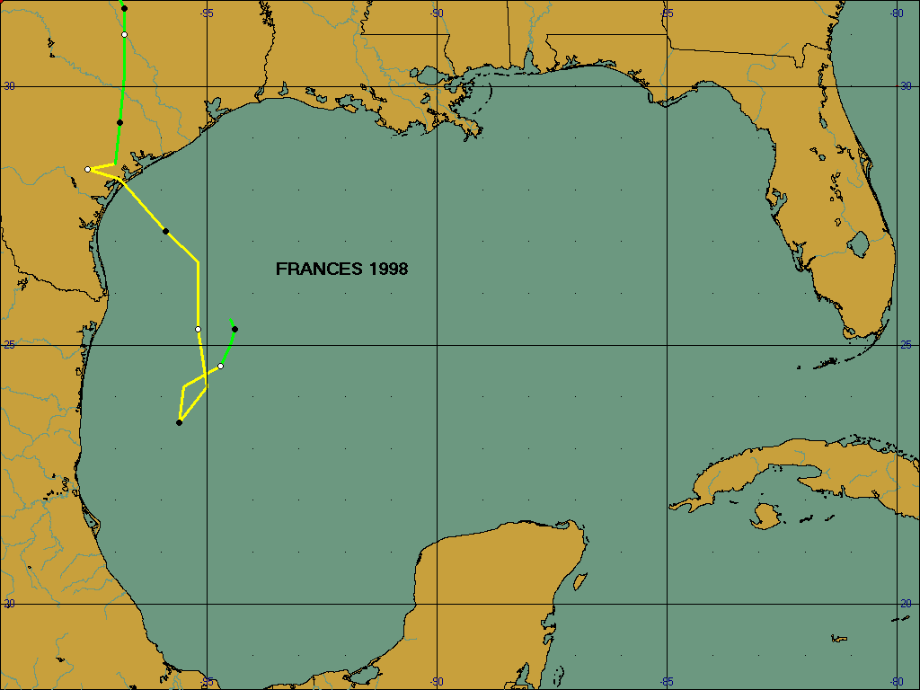
On Monday September 7th (Labor Day), a tropical disturbance in the western Gulf of Mexico was increasing the pressure gradient along the Texas coast. A weak cold front had pushed south to near the Red River by Tuesday evening. At 4PM Tuesday, the disturbance was upgraded to a tropical depression located about 250 miles south of Galveston. The depression drifted southward for about a day. On Wednesday morning the cold front had sagged down to a Lufkin to Dallas line with a 1022mb high pressure system centered over the Ohio Valley. At 4 PM on the 9th, the depression was upgraded to a Tropical Storm and given the name Frances. Winds along the upper Texas coast were from the ENE 20 to 30 mph with gusts nearing 40 mph. The poorly organized tropical storm center of circulation was still located about 250 miles south of Galveston with maximum sustained winds of 40 mph. On Thursday, the storm remained disorganized and was located about 190 miles south of Galveston. On Thursday afternoon the storm had deepened and maximum sustained winds had increased to near 60 mph. The surface ridge of high pressure had now shifted to the southeast centered over Tennessee increasing the pressure gradient and the winds along the upper Texas coast. Frances then moved to the north and to the northwest and on early Friday morning neared the Texas coast near Port O'Connor. Winds along the upper Texas coast continued at 30 to 40 mph sustained winds with gusts near 50 mph at times. Frances moved inland just southwest of Victoria and remained nearly stationary throughout the day on Friday. On Friday evening, Frances began moving to the north northeast. At 7 PM, Frances was downgraded to a tropical depression as it moved to the northeast of Victoria. At 10 PM, the remnants of Frances were located about 65 miles west of Houston and it was longer being tracked by the National Hurricane Center. The remnants of Frances continued northward to the Texas/Oklahoma border north of Dallas and then northward toward Iowa.
...Tides...
Most of the damage along the coastal communities can be attributed to the high tides that persisted for nearly two days. The high tides in Galveston Bay also enhanced the flooding problems experienced further inland by the heavy rains. A Coastal Flood Watch was issued Monday night concerning the possibility of high tides beginning on Tuesday with tides expected to run 3 feet above predicted levels. On Tuesday afternoon the Coastal Flood Watch was updated to extend the watch into Wednesday with tides predicted to be 3 to 4 feet above predicted levels by Wednesday afternoon. At 4PM Tuesday, tropical depression status was reached and a Tropical Storm Warning was issued for the Texas Coast from High Island to Brownsville. The Tropical Storm Warning implies that a Coastal Flood Warning is also in effect. On Wednesday, the tide forecast was updated with a forecast of tides 4 to 5 feet above predicted levels expected on Thursday. On Thursday, the tides were forecasted to increase to levels of 4 to 6 feet above the predicted levels on Friday.
On the beach front at Galveston Pleasure Pier, the tides rose above 4 feet above MLLW on Wednesday afternoon (Sept. 9) and remained above this level until Friday afternoon (Sept. 11). The maximum level was reached on Thursday evening when the gauge read around 7 feet above MLLW or about 4.5 feet above the predicted levels. In Galveston Bay, a similar even took place. At Eagle Point, the tides rose above 4 feet above MLLW on Wednesday evening (Sept. 9) and stayed above this level until after midnight on Sept. 12. The peak height reached was around 5.7 feet above MLLW during the early morning hours of Sept. 10 which is 4.7 feet above the predicted levels.
Similar conditions were found along the entire upper Texas coast from High Island to Matagorda and in the inland bays. Tides were above 4 feet MLLW for 36 to 48 consecutive hours and winds were in excess of 25 mph through the same period which led to the destructive waves along the beach front. These destructive waves resulted in most of the dune systems from High Island to Sargent, Texas being almost completely destroyed.
...Winds and Pressure...
Winds ranged from 25 to 35 knots (29 - 40 mph) for over 24 hours starting around midnight on Sept 10 and continuing until the early morning of Sept 11. The strongest wind recorded was 47 knots (54 mph) at Galveston Scholes Field around 6PM on Sept. 10. Other peak winds recorded around the area included 46 knots (53 mph) at Palacios and 31 knots (36 mph) at Houston Intercontinental Airport. The lowest atmospheric pressure recorded was at Palacios when the barometer read 29.38 inches at 254 PM on Sept. 11. Galveston lowest pressure was 29.48 inches at 529 AM on Sept. 11.
...Rainfall...
Rainfall from Tropical Storm Frances began effecting the coastal areas during the morning on Thursday and conditions slowly spread inland Thursday afternoon and further inland early Friday morning. Over 4 inches of rain fell over all of the Houston/Galveston County Warning area. Over 10 inches of rain was common along the coastal counties of Matagorda, Brazoria, Galveston and Chambers and also over inland counties including Harris, Polk, San Jacinto and Washington. With tides already running 4 to 6 feet above normal, the runoff from the rains was not able to easily runoff into the bays. This led to more widespread flooding of inland creeks and bayous, especially early Friday morning.
...River and Bayou Flooding...
September was an active month across the HSA with Tropical Storm Frances dumping 4 to 6 inches of rain over the region. Large areas received 8 to 10 inches of rain with some areas receiving more than 12 inches. The result was significant flooding in many areas. Flooding was exacerbated in many areas by tides 4 to 6 feet above normal. Significant rises occurred on the San Bernard River in Brazoria County from above Sweeny to the mouth on Sept. 9 with flood stage exceeded on Sept 10. This rise was mainly due to strong tidal influence. Significant rains began on Sept. 10 and continued through the Sept. 12. The majority of the rain occurred during the morning hours of Sept 11as Frances made landfall.
By daybreak Sept. 11, significant flooding was occurring in Harris County and the City of Houston. Homes in Jersey Village and Woodland Trails in northwest Houston along White Oak Bayou were flooding by 6AM. Most subdivisions along White Oak Bayou experienced house flooding. Homes were also flooded on Halls Bayou above I-45, on Brays Bayou at Lawndale near the confluence with the Houston Ship Channel, and on Armand Bayou near Spencer Highway in Pasadena. I-10 between the West Loop and downtown Houston and I-45 near North Main Street were closed by 9 AM due to flooding from Buffalo and White Oak Bayous. State Highway 288 was closed due to flooding from Brays Bayou. Overall, more than 1400 homes and businesses were damaged or destroyed in this event.
In Brazoria County, Chocolate Bayou near Alvin exceeded its banks in the channel above FM 1462 to the mouth at Chocolate Bay. Several minor roads were impacted by this flooding.
Significant flooding occurred on the San Bernard River above U.S. Highway 59 near Kendalton to the mouth. Primary flooding above FM 442 near Boling was due to backwater on the tributaries of Peach and West Bernard Creeks in Wharton County. While no homes were reported flooded, several roads in the El Lobo subdivision were inundated. A combination of strong tidal influence and heavy rain produced the rise in the channel above Sweeny to the mouth. While low lying areas along the river were flooded, the most significant impact was on barge traffic at the Phillips Petroleum Facility.
The Tres Palacios River in Matagorda County began rising at the rate of one foot an hour during the evening hours of Sept. 10 resulting in moderate lowland flooding above State Highway 71 near Midfield to the mouth at Tres Palacios Bay. Significant backwater up Juanita Creek, about one mile upstream from the gaging station FM 456, was also noted. Several farm to market and county roads in Matagorda County were inundated by this flood. There were no reports of homes flooded; however, several areas were isolated due to the flooded roadways.
Flooding on East Mustang Creek near Louise in Wharton County closed FM 647 for several hours on Sept. 12. Secondary and minor roads near the creek were also inundated.
Several small ungaged watersheds in Chambers, Galveston, Brazoria, Matagorda, Fort Bend and Wharton Counties flooded. This resulted in the closing of many farm to market and county roads with several homes and subdivisions threatened. These included Dickinson Bayou in Galveston County, Oyster Creek in Brazoria County and Caney Creek in Matagorda County.
Water had receded on all but the San Bernard and Tres Palacios Rivers by the afternoon of Sept. 12. There were no deaths or serious injuries due to river flooding associated with this event. Galveston, Harris, Brazoria and Matagorda Counties were all declared disaster areas.
There were only 3 deaths that can be attributed to Tropical Storm Frances. A father and daughter drowned on Galveston Island while swimming in the surf during the day Monday. The third death occurred on Wednesday when a surfer drowned on the beaches of Surfside in Brazoria county while surfing the large waves.
...Summary...
Tropical Storm Frances brought home how vulnerable the Texas Coast is to tropical weather systems even if they do not achieve hurricane strength. Since Frances never achieved hurricane strength, the citizens along the upper Texas Coast never realized the damage that could result from just a tropical storm. With a long siege of high tides coupled with Tropical Storm Force Winds it was very similar to having a strong category one hurricane. The rains that accompanied the storm were fairly normal for a slow moving tropical storm, but flooding was aggravated by the high tides that were already in place when the heavy rains began.
A track map of Frances can be found here.
More information on Frances is available in the National Hurricane Center's Tropical Cyclone Report.
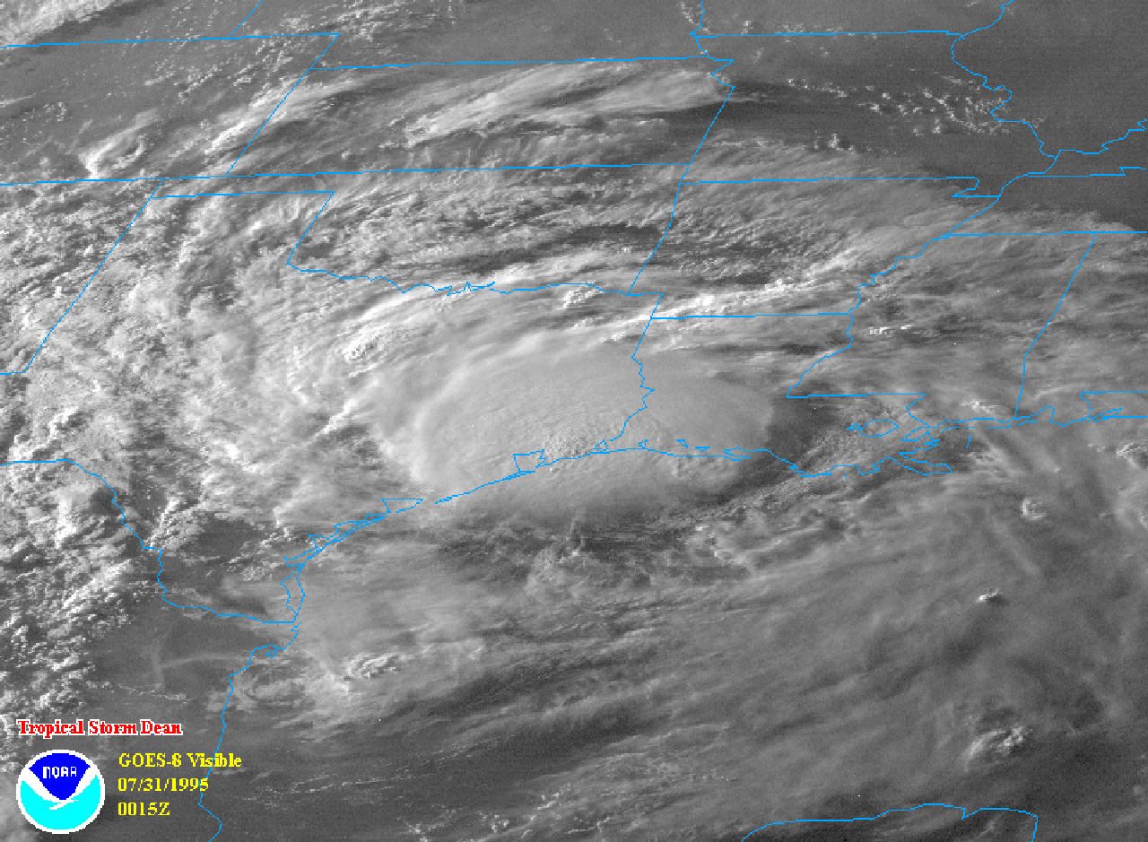
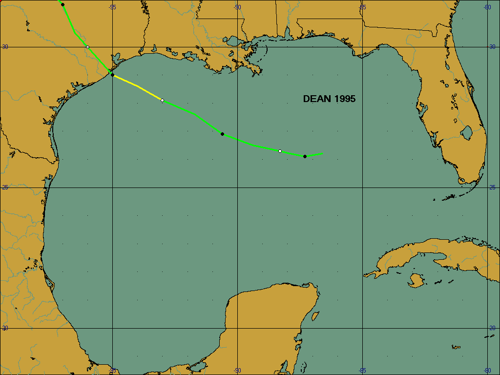
On July 27th, a weak cyclonic circulation with surface pressure falls of 2.5 mb in 24 hours was indicated by buoy reports in the eastern Gulf of Mexico while at the upper levels of the atmosphere, a broad quasi-stationary trough extended from the northeastern Gulf of Mexico through Florida. Based on satellite and surface data, this system was upgraded to tropical depression status about 300 miles southeast of New Orleans on the 28th. The depression moved slowly toward the west-northwest around a well-established high pressure ridge over the central United States. After some intensification, the depression became Tropical Storm Dean during the afternoon on the 30th about 60 miles off the Texas coast. The center of Dean crossed the coast near Freeport, TX a few hours later. Two tornadoes (one at High Island and the other just southeast of Anahuac) briefly touched down causing minor damage as Dean made landfall. Dean weakened to a depression after landfall and continued on a northwestward track through TX. The depression became nearly stationary for about 24 to 36 hours over the northwest portion of the state producing heavy rainfall. Monroe City, TX recorded 16.78 inches, and over 14 inches of rain was recorded near Vernon, TX. Dean dissipated on 8/2 as it merged with a frontal zone.
A recorded peak wind of 51 mph occurred at Galveston Scholes Field. The lowest pressure was 1003.4 mb...also at Scholes field. Tides were 3.0 to 3.5 feet above normal and ranged from 3.3 feet at Morgans Point to 4.8 feet at Pleasure Pier above lower low water. Minor storm surge flooding of Highway 87 was observed. Dean produced very heavy rains across portion of Chambers and Southern Liberty Counties. Based on unofficial rainfall reports east of Anahuac and radar precipitation estimates...15 to 18 inches of rain fell in central Chambers into extreme southern Liberty Counties between High Island and Liberty. The greatest amount actually measured was the previously mentioned 16.78 inches just east of Monroe City in Chambers County. Evacuation of 20 families was necessary in Chambers County due to rainfall flooding. There were no reports of injuries or deaths associated with Dean. Total damage was nearly $500,000.
A track map of Dean can be found here.
More information on Dean is available in the Tropical Prediction Center's Tropical Cyclone Report.


 Follow us on YouTube