| Severe Weather Safety Campaign March 6 - 10, 2017 |
|---|
FORECASTING
 AWIPS (Advanced Weather Interactive Processing System) is the name of the computer system being utilized by the National Weather Service. It enables the forecaster to put several layers of information on one screen, allowing for faster and more accurate weather predictions. AWIPS (Advanced Weather Interactive Processing System) is the name of the computer system being utilized by the National Weather Service. It enables the forecaster to put several layers of information on one screen, allowing for faster and more accurate weather predictions.  Warngen is a tool on AWIPS that allows the meteorologist to create a warning right from the radar screen. The meteorologist can box in the area he feels will be affected by the storm, and a warning is automatically created to cover that set of counties. Warngen allows for faster and more precise warnings from the National Weather Service.
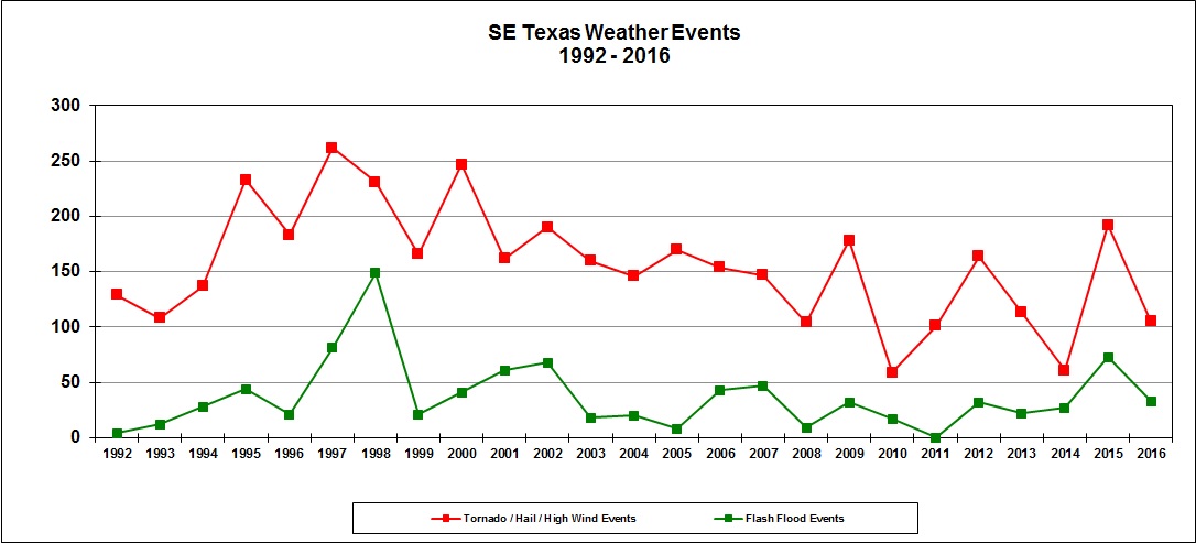
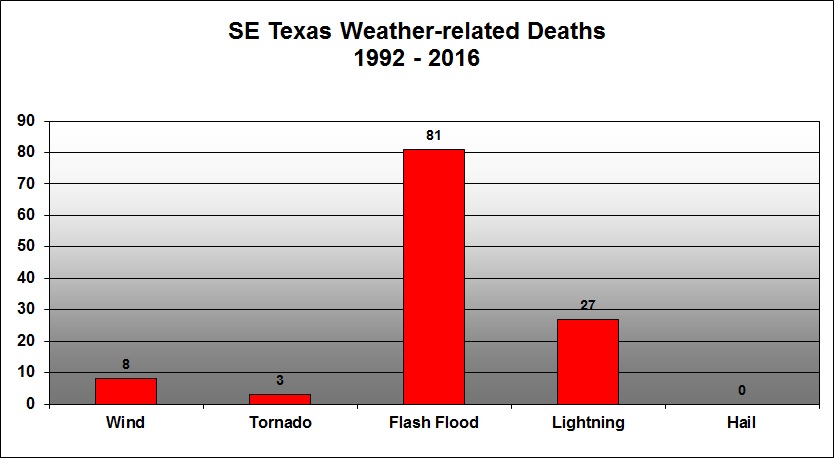
WSR-88D Doppler Radar  Satellite One of the oldest and most reliable tools in severe weather forecasting is the weather satellite. Meteorologists can monitor evolution of storm systems as they approach the area, and compare them to computer model predictions of their strength and movement. When thunderstorms evolve, meteorologists can watch for areas of cooling or warming cloud tops on infrared satellite imagery to tell if the thunderstorms are intensifying or weakening. Visible satellite photos can be used to monitor initiation of convection (developing cumulonimbus clouds) and areas with the highest cloud tops and strongest storms. Day-to-Day Operations at the National Weather Service  At least two meteorologists are on duty twenty-four hours a day, seven days a week at the Houston/Galveston National Weather Service office. One meteorologist serves as the lead, making decisions on the five-day forecast and writing the forecast discussion, a summary of the meteorologist's scientific reasoning behind his or her forecast. One meteorologist serves as the aviation and marine forecaster, and concentrates on those activities. The third meteorologist serves as a technician, answering phones, gathering climate and weather statistics, and monitoring the radar and NOAA Weather Radio. At least two meteorologists are on duty twenty-four hours a day, seven days a week at the Houston/Galveston National Weather Service office. One meteorologist serves as the lead, making decisions on the five-day forecast and writing the forecast discussion, a summary of the meteorologist's scientific reasoning behind his or her forecast. One meteorologist serves as the aviation and marine forecaster, and concentrates on those activities. The third meteorologist serves as a technician, answering phones, gathering climate and weather statistics, and monitoring the radar and NOAA Weather Radio. During times of severe weather, additional meteorologists will be on duty to help with the increased workload. Severe weather duties include radar monitoring, issuing warnings, statements, and short-term forecasts, fielding phone calls from spotters and law enforcement officials, compiling reports of severe weather, disseminating warning information via NOAA Weather Radio, pager, and telephone, and issuing the regular products associated with a shift. Typically, two or three meteorologists will be assigned solely to radar and warning operations during severe weather events with other duties distributed around as necessary. Severe Weather Statistics for Southeast Texas (1992-2016)
   |


 Follow us on YouTube