|
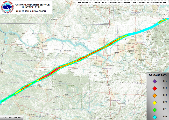
This is updated information concerning cumulative storm survey information of the extensive damage incurred across Franklin (Alabama), Lawrence, Limestone, Madison, and Franklin (Tennessee) counties. This information is the combined effort by the National Weather Service, local emergency management, a storm survey expert from the University of Alabama in Huntsville, and collaboration with a structural engineer and survey expert. Detailed findings have found one complete tornado track from southern Franklin County Alabama to near Huntland in Franklin County Tennessee.
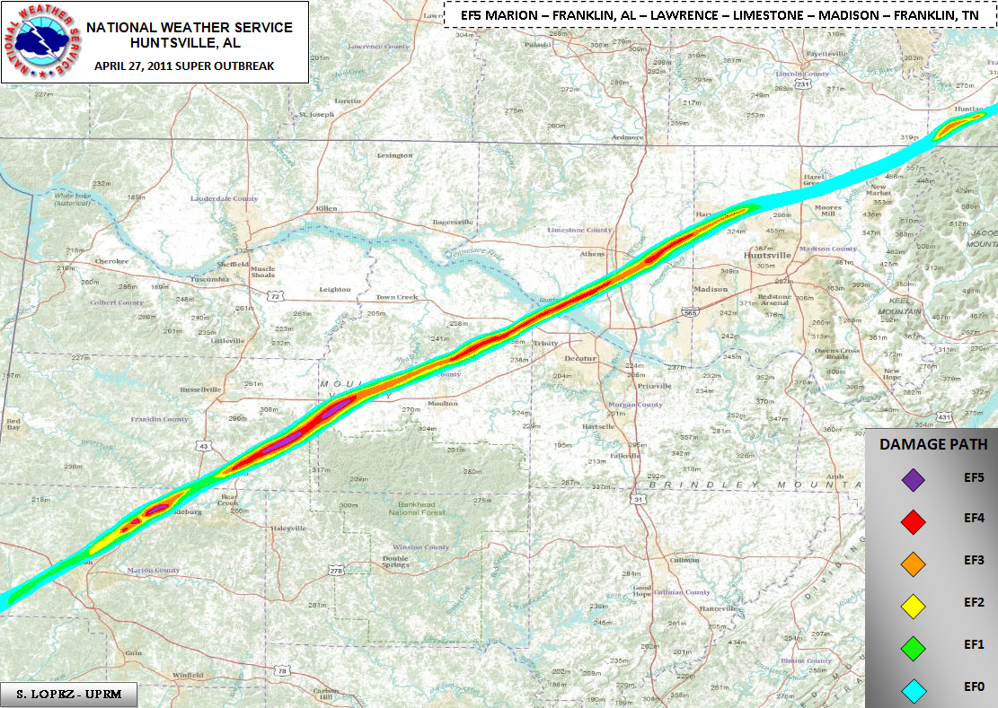
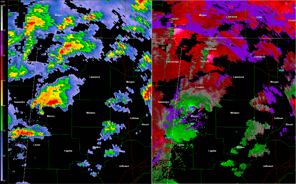
Franklin and Lawrence Counties
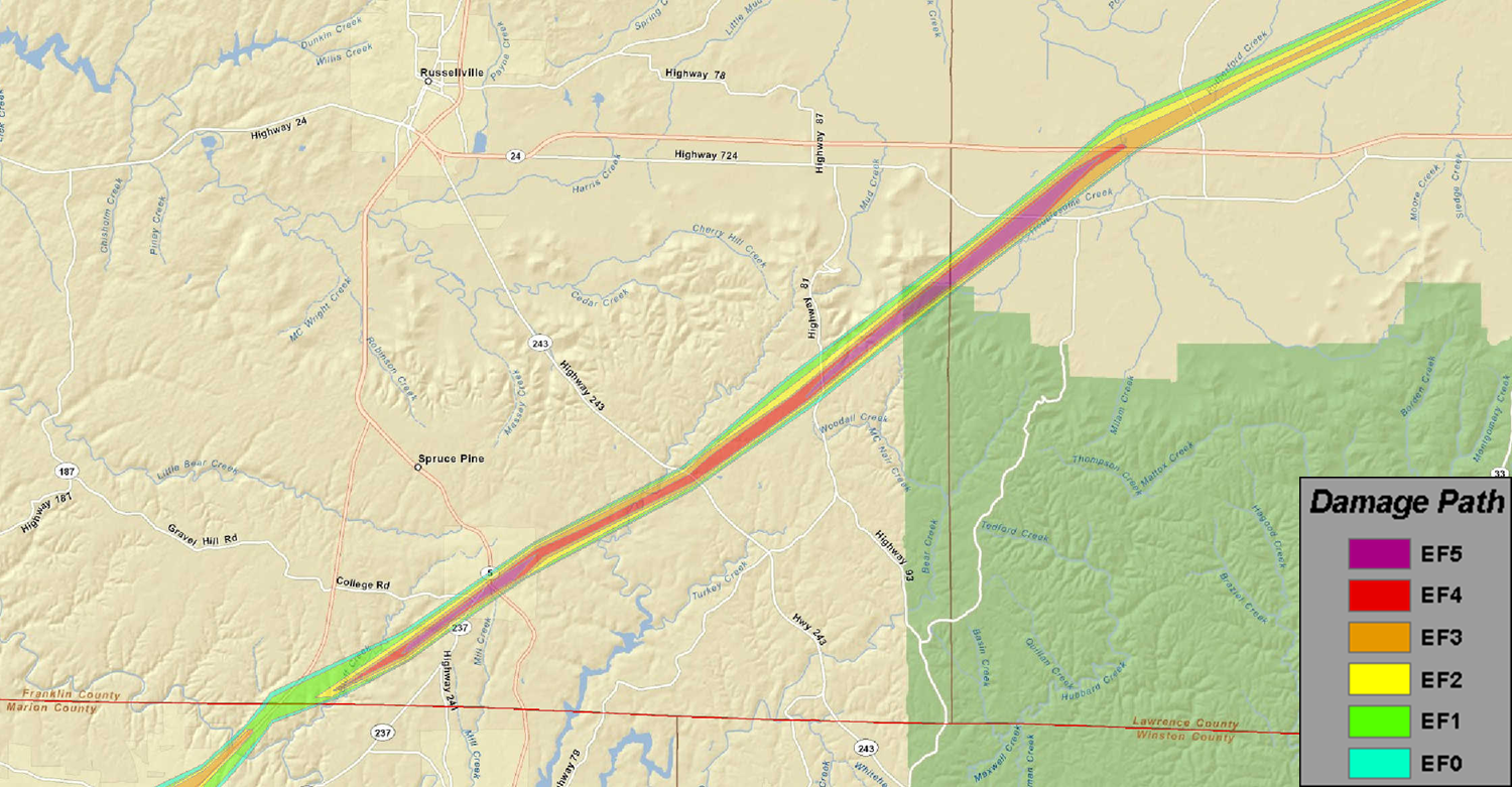
The actual tornado track began in Marion County, AL. The survey for the track damage across Marion county was done by the National Weather Service in Birmingham, AL. The survey conducted by the National Weather Service in Huntsville, AL began at the southern Franklin County/Marion County line north of Hackleburg, AL. The survey team traveled through Phil Campbell and witnessed continuous significant devastation throughout the city.  Prolific damage was noted from the intersection of County Road 51 and Alabama highway 237, to the intersection of County Road 81 and County Road 75. Within a 2 mile corridor either side of the railroad tracks the damage was significant. Within this corridor, several well-constructed houses were destroyed. Along Brown Street, block homes were leveled to the ground. Along Bonner Street, multiple block homes were leveled to the ground with the block foundations destroyed. A 25 foot section of pavement was sucked up and scattered. Chunks of the pavement were found in a home over 1/3 mile down the road. The damage in this area was deemed to be EF-5. In addition, at least 3 churches along the path sustained significant damage. One church in Phil Campbell was completely destroyed with only the slab remaining. Multiple mobile homes throughout the path were completely destroyed, and their mangled frames were tossed 25 to 50 yards. Cars were tossed and destroyed throughout the path of the tornado, with one car wrapped around a debarked tree in Phil Campbell. All along the path length, thousands of hardwood and softwood trees were snapped. Hundreds of trees were also debarked and twisted, and had only stubs of the largest branches remaining. EF-5 damage continued similarly northeast from Phil Campbell, roughly along County Roads 81 and 82 toward the community of Oak Grove. Prolific damage was noted from the intersection of County Road 51 and Alabama highway 237, to the intersection of County Road 81 and County Road 75. Within a 2 mile corridor either side of the railroad tracks the damage was significant. Within this corridor, several well-constructed houses were destroyed. Along Brown Street, block homes were leveled to the ground. Along Bonner Street, multiple block homes were leveled to the ground with the block foundations destroyed. A 25 foot section of pavement was sucked up and scattered. Chunks of the pavement were found in a home over 1/3 mile down the road. The damage in this area was deemed to be EF-5. In addition, at least 3 churches along the path sustained significant damage. One church in Phil Campbell was completely destroyed with only the slab remaining. Multiple mobile homes throughout the path were completely destroyed, and their mangled frames were tossed 25 to 50 yards. Cars were tossed and destroyed throughout the path of the tornado, with one car wrapped around a debarked tree in Phil Campbell. All along the path length, thousands of hardwood and softwood trees were snapped. Hundreds of trees were also debarked and twisted, and had only stubs of the largest branches remaining. EF-5 damage continued similarly northeast from Phil Campbell, roughly along County Roads 81 and 82 toward the community of Oak Grove.
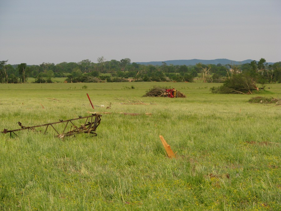
In Oak Grove, the tornado may have reached a relative maximum in intensity well into the EF-5 category as the damage was slightly more intense and the path width was at a maximum of greater than one mile. A large swath of complete devastation was noted in Oak Grove along County Roads 38 and Smith Lane. A large well-constructed home with extensive anchoring was razed with debris carried well away from the site. A Corvette sports car was mangled and thrown 641 feet (measured). Another large vehicle is still missing. A block home next door was also disintegrated. Along Smith Lane a block home was wiped out and the only remains of a nearby chicken house was a small piece of a metal truss. In this same area, the tree damage was complete and a large percentage of trees were stripped bare.
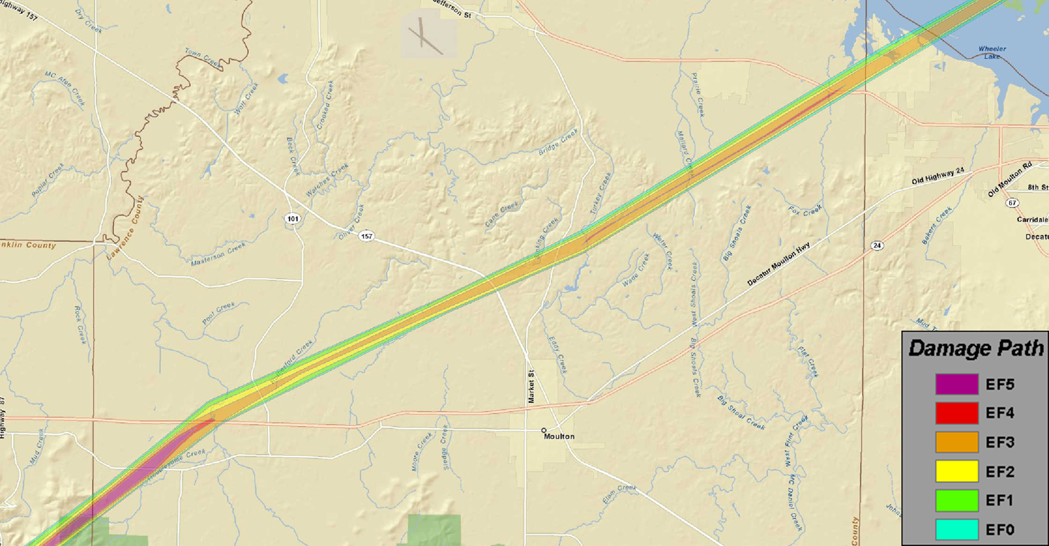
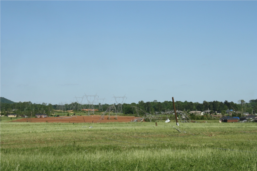
The tornado continued to track northeast into Lawrence County as an EF-5 near the Mt. Hope area where significant devastation was incurred to single family homes and a restaurant. Nothing but the foundation and a pile of debris remained in this area, and a small portion of the restaurant foundation buckled. Thousands of hardwood and softwood trees were snapped, with a significant number of trees twisted and debarked with only stubs of branches remaining. Many mobile homes were also destroyed with the frames mangled, and a single family home was completely destroyed with the walls and contents strewn over a hundred yards. Further northeast the damage was slightly less intense, with more trees snapped and twisted as the tornado reached Highway 24. At this location multiple chicken houses were completely destroyed with much of the debris wrapped around debarked trees. TVA high voltage power line trusses were also destroyed at this location. As the tornado continued northeast more significant damage occurred in and around the Langtown community north of Moulton. On the west side of Alabama Highway 33, several homes sustained significant damage with roofs missing or only interior rooms remaining. A nearby store and gas station also sustained significant damage. The tornado strengthened again to a high end EF-4 as it moved into County Roads 214 and 298, where multiple houses and mobile homes were completely destroyed. Several cars were tossed into fields and wrapped around trees along County Road 291 and 292. One vehicle was tossed into a large hardwood tree that was also debarked. Tree and mobile home damage continued along County Roads 217 and 222, where a handful of large high tension TVA power poles were destroyed. Sustained EF-4 damage continued northeast towards Alabama Highway 20, where a restaurant was completely destroyed and two single family houses were significantly damaged. Tree damage continued into extreme northwestern Morgan County.
|
|
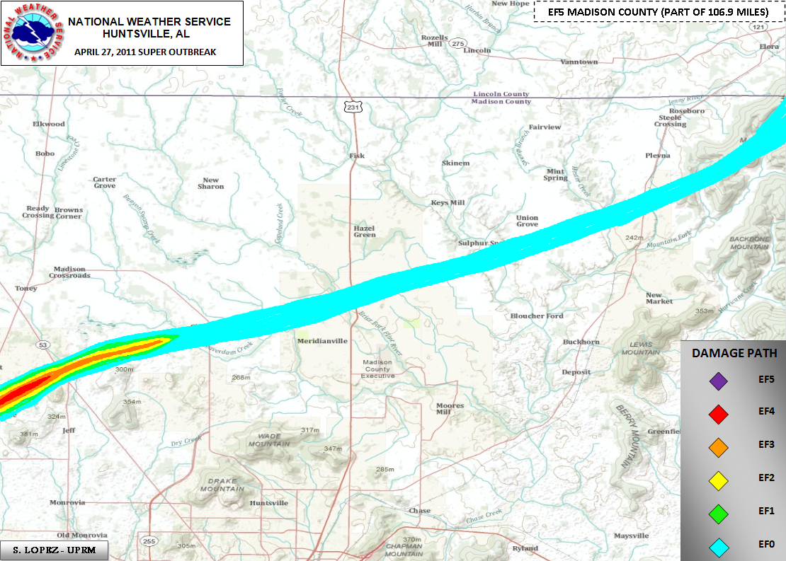
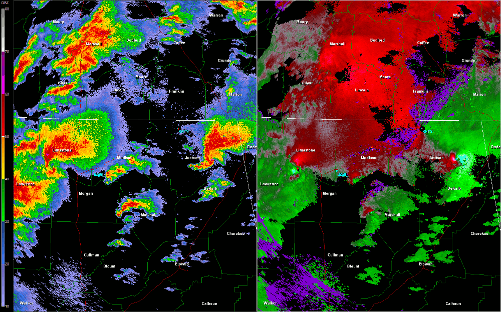
Limestone and Madison Counties
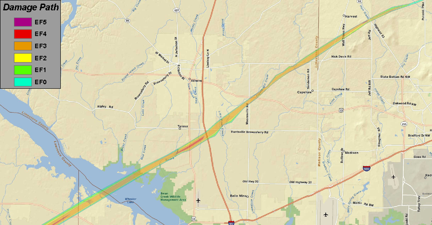
An initial aerial survey was conducted on Thursday morning from the Tennessee River along the Lawrence/Limestone county line northeast through Tanner and into Madison County beyond the Anderson Hills subdivision. Several areas of intense damage were noted along a solid track with the most intense damage noted near the community of Tanner and near Anderson Hills in Madison county. Homes were completely obliterated along a wide swath in both of these areas. Nearly a dozen high tension power lines were snapped or taken to the ground in Limestone County. Concrete power poles were also snapped off at their base. A subsequent ground team, aided by a storm survey expert from the University of Alabama in Huntsville, surveyed the most intense damage in Limestone County. High end EF-3 damage was noted over a large area in eastern Limestone County along and north of the East Limestone High School. The intensity was maximized in Limestone County in the community of Tanner, with a large swath of EF-4 damage and a narrow corridor of high end EF-4 to near EF-5 damage. Several well-constructed homes with anchor bolting were completely wiped clean. One home had the debris lofted over 300 hundred yards with large items carried completely away. Intense ground scarring was noted in this area. In addition, a large cargo container was picked up and blown approximately 600 yards and several cars were carried airborne for hundreds of yards. In all, hundreds of homes received moderate to major damage along the path with many of these being total losses. The tornado crossed into Madison County east of the Limestone County prison, along Orvil Smith Road with a path width of 1/2 mile. The tornado maintained an EF-3 strength with winds of 140 to 160 mph and a path width of 1/4 to 1/2 mile for much of its track east-northeast across Old Railroad Bed Road and Ford Chapel Road, before narrowing to around 300 yards in Anderson Hills. Dozens of well-constructed homes were destroyed, in some cases with all exterior walls collapsing in both single and two story homes. At least 3-5 mobile homes were either destroyed or swept completely away. At least 2 other well-constructed homes had complete wall collapse in Anderson Hills and were shifted off their foundation. This damage was once again consistent with low end EF-4 wind speeds of around 170 mph. Numerous tall pines and other hardwood trees were snapped, uprooted and debarked along the entire path. The path width widened once again to up to 1/2 mile as the tornado tracked through residential areas along Bald Eagle Lane, Old Eli Road, and Ginnery Row. Several of these homes had complete wall collapse, but these structures had foundation straps and nails in lieu of bolts. At least one fatality was confirmed at one of these residences. This damage was consistent with high end EF-3 wind speeds of 140 to 160 mph. The tornado lifted just south of Patterson Lane after twisting irrigation equipment and snapping additional trees. An EF-0 tornado with peak wind speeds of 70 mph redeveloped along Grimwood Road and Walker Lane south of Hazel Green, uprooting or snapping a few trees. The tornado weakened or may have lifted very briefly across northeast Madison County before strengthening again as it entered Franklin County Tennessee.
During much of the lifecycle of this tornado across north Alabama, there was evidence of possible satellite vortices which caused points of more severe damage as compared to adjacent residences. There were also several trees knocked down just outside the periphery of the tornadic circulation which were likely due to mesocyclone winds which were convergent toward the tornado.
|
|
Franklin County Tennessee
More storm damage was surveyed by National Weather Service personal on Friday and Saturday (April 29th and 30th) across southwest Franklin County Tennessee. The long track tornado that affected parts of northern Alabama created more damage south of Huntland. Isolated and minor EF-0 tree damage was noted at the intersection of John Hunter Highway (State Route 122) and Limestone Road near the Lincoln/Franklin county line.
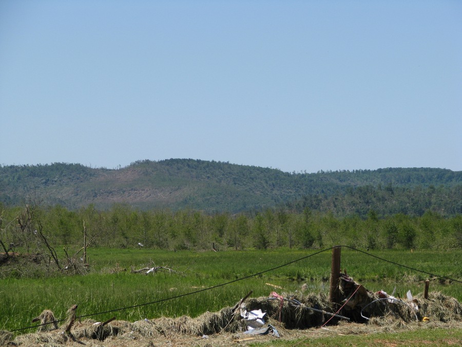
More significant damage was noted, starting about 1.4 miles south southwest of Huntland. A cinder block building suffered damage to its flat adobe roof, with some of blocks near the roof (around 20 feet off of the ground) pushed out, resulting in EF-2 damage. Surveyors could not directly examine the roof given this building was on the highest ground in the vicinity. Nearby, a single family home of cinder block construction had its roof totally removed, with another home about 1000 feet away having significant roof damage, with over one half of its roof removed, and some shifting off of its foundation. Damage with the latter was consistent with high end EF-2 damage. A chicken building with metal girding, nearby the second home, was completely flattened, consistent with EF-2 damage. A farm complex south of Hickory Grove Road had damage to a number of structures there. The home and the main car garage had part of their roofs removed. A barn that was protecting bales of hay was destroyed, with a few bales blown approximately 100-200 feet from their original location. The worst damage was noted with lower end EF-3 damage to a cinder block utility building about 200 feet south of the primary residence. Most of its roof was removed, with over half of its downwind wall pushed outward. An older barn nearby suffered lesser EF-0 damage to its roof, while the top half of a silo near that barn was missing. Another barn structure was completely destroyed northwest of the primary home. The width at this point was approximately 1/4 mile. Other damage was noted near the intersection of Hickory Grove Road and Sugar Cove Road, with EF-1 damage to some heavy farm equipment and EF-0 roof damage to a nearby barn. Scattered trees were downed to the northeast, with 8 inch fence posts, anchored 18 inches deep, pulled up near Hickory Grove and Buncombe Road. There was evidence the tornado continued toward the mountains a few miles further east, with some trees damaged along the ridge.
Complete Tornado Track Map (Click on the map for a larger version.)
Radar Data
|


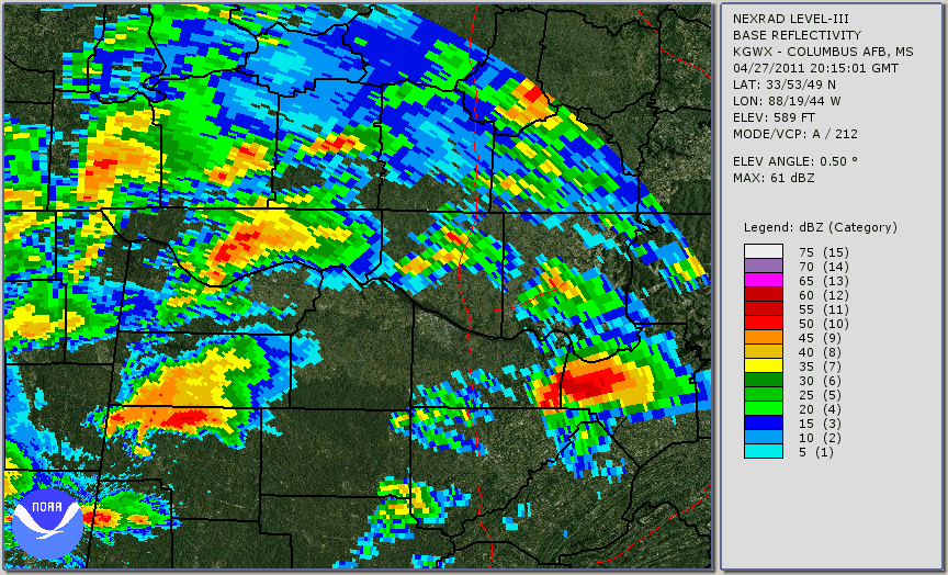
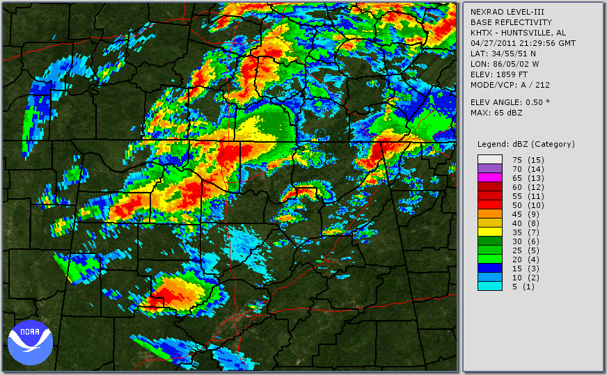


 Local Radar
 Weather Map
 Follow us on YouTube