|
|
||
|
Dual Polarization (or "dual-pol") technology adds an additional 14 products to the suite of data already available to NWS forecasters. These tools will assist forecasters in the warning and forecast process.
Why upgrade to Dual Polarization Radar? By comparing the power and timing of energy returned to the radar from both horizontal and vertical pulses, we can glean information such as the size, shape, and composition of precipitation particles.
What are the Potential Benefits of Dual-Pol? |
||
|
||
|
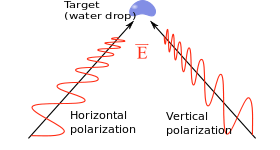
What is polarization? A radio wave is a set of oscillating electric and magnetic fields, oriented 90 degrees to each other. Polarization of the wave is the direction, or orientation, of the electric field. Horizontal Polarization The electric field is oriented horizontally, along the x-axis.
Vertical Polarization The electric field is oriented vertically, along the y-axis.
|
||
|
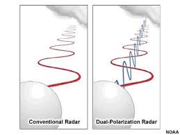
"Old" NWS Doppler Radar (horizontally-polarized only) versus "Dual Polarized" Radar The old Doppler radar capability transmits and receives only horizontally polarized radio wave pulses. Therefore, they measure only the horizontal dimension of cloud and precipitation particles. New dual-pol capability will allow the transmit and receipt of both horizontally and vertically polarized radio wave pulses. Therefore, they measure both the horizontal and vertical dimension of cloud and precipitation particles.
More Information |


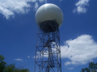
 Local Radar
 Weather Map
 Follow us on YouTube