|
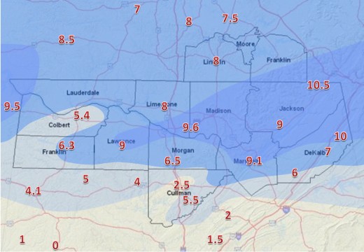
A snow/sleet accumulation map from January 6-8, 1988. Accumulation reports are plotted on the map. The contours delineate areas that received less than 3", 3"-6", 6"-9", and greater than 9". Click on the map for a higher resolution version of this image.
On January 6-8, 1988, a significant winter storm brought snow, sleet, and freezing rain to much of the Southern Plains, Southeastern, and Mid Atlantic states. Multiple intrusions of Arctic air over the first several days of the year brought well below average temperatures to the Tennessee Valley. A low pressure system developed over the northwestern Gulf of Mexico on January 6th and tracked across the northern Gulf over the next few days. The system spread moisture over the shallow cold air mass, setting the stage for a historic winter weather event over north Alabama and southern middle Tennessee. As of this writing, the 9.6" inches of snow that fell at Huntsville stands as the city's second-highest storm total accumulation.
Weather Synopsis

|
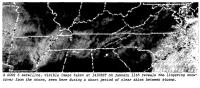
| An infrared satellite image taken by GOES-7 around 7 AM on January 7, 1988. The brighter radiances over the Southeastern U.S. show the colder cloudtops associated with wintry precipitation spreading across the area. Click to view the full image. (Courtesy NCDC) |
The upper level pattern in early January 1988 featured a series of longwave troughs developing and deepening over the central and eastern continental United States and a sustained blocking ridge along the Pacific coast of North America. The first longwave trough of the new year affected the eastern United States on the 1st and 2nd of the month. An associated cold front brought a polar airmass into the Southeast, with temperatures falling to around 5 degrees below normal across the Tennessee Valley as the front moved through on the evening of Friday, January 1. A deeper trough (500 millibar heights over the Great Lakes region on the order of 15-20 decameters lower than with the previous system) developed and moved over the Plains and eastern United States from Sunday, January 3rd through the Tuesday, January 5th. The surface front associated with this upper wave brought the proverbial mother lode of arctic air deep into the southeastern United States. The front moved across the Tennessee Valley during the day Monday, January 4th, with temperatures falling through the day across the area. Once the temperature went below freezing around sunset that evening in Huntsville, it stayed below freezing until the afternoon hours on Thursday, January 7th - almost 72 consecutive hours of sub-freezing temperatures.
Behind this trough, the upper level pattern became more zonal over the southeastern United States, and that pattern continued through the remainder of the week. A shortwave trough developed and tracked across the four corners region on Wednesday, January 6th. As the shortwave moved across the southern Plains states on the evening of the 6th, it forced surface cyclogenesis in the favored baroclinic zone along the Texas Gulf Coast. Though the minimum pressure of the surface cyclone over the Gulf of Mexico was only around 1016-1020 millibars (mb), the system showed a healthy vertical tilt and was producing a broad area of isentropic ascent downstream of an 850 mb low centered over the Red River Valley. Clouds and precipitation developed in association with this area of lift and spread across the Southern Plains and southeastern United States. At the surface, temperatures remained below freezing over the Tennessee Valley as the shallow arctic air mass held strong.
 |
| A surface weather map from the morning of January 7th shows the storm tracking along the northern Gulf of Mexico, with wintry precipitation occurring the Tennessee Valley. (Courtesy NOAA Central Library Data Imaging Project) |
By the afternoon hours of the Thursday, January 7th, the shortwave trough and a 500 mb vorticity maximum were moving across the lower and middle Mississippi River Valley, and the 850 mb low was centered near Memphis, Tennessee. The surface low had advanced to near Mobile, Alabama, and had shown no real change in strength. An inverted trough now extended northward from the surface low across Alabama and into eastern Tennessee. Weak warm advection continued ahead of the system, and surface temperatures over north Alabama had warmed to around the freezing mark. High pressure was firmly entrenched over the upper Midwestern states extending into the New England states. The pressure gradient between this and the low over the Gulf of Mexico lead to gusty winds over the Tennessee Valley. In addition, cold air damming was taking place on the eastern side of the Appalachian Mountains due to the orientation of the surface high pressure system. This setup brought much drier air into northern Georgia, which kept temperatures below freezing in the Atlanta area through the duration of the event, via dynamical cooling associated with evaporation. While it appears the effects of cold air damming were minimal over northeast Alabama, it is possible that it did help prevent surface temperatures from rising much above freezing.
The shortwave and associated vorticity max tracked along the Atlantic seaboard on Friday, January 8th. The surface low strengthened significantly along the East Coast and brought substantial snowfall to parts of the Mid Atlantic states and New England. Surface high pressure became reestablished over the Southeast by Saturday, January 9th. After briefly eclipsing the freezing mark on Thursday, temperatures stayed below freezing in Huntsville for nearly three straight days before barely surpassing 32°F on Sunday the 10th.
Event Summary
 |
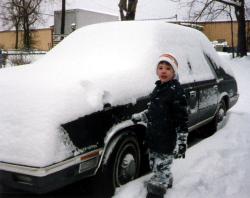
| Christopher Arthur of Russellville stops playing in the snow for a picture on the morning of January 7th. Click to view the full image.(Courtesy Lilly Claude Rooks/Christopher Arthur) |
As early as the beginning of the week, National Weather Service forecasts began to point to some type of frozen precipitation for North Alabama and South Tennessee. As the event got closer, forecasters were able to further refine the details of the forecast. By Wednesday morning, a Winter Storm Watch was posted for the Tennessee Valley. This was upgraded to a Heavy Snow Warning for North Alabama by Thursday morning.
Precipitation began to spread northward across north Alabama and southern middle Tennessee late Wednesday night (the 6th) and early Thursday morning (the 7th). It began as all snow for the far northern part of Alabama, including the Huntsville and Shoals areas. The ground had already begun to turn white by midnight in Huntsville. Farther south, in Cullman County and along the I-20 corridor in the Birmingham area, precipitation began as sleet due to a warm layer in the lower levels of the atmosphere.
During the early morning hours Thursday, the snow/sleet line edged northward, with a changeover from snow to sleet occurring in Huntsville shortly after daybreak. As the day wore on, the temperatures in the lower part of the atmosphere warmed to a point that caused the ice to completely melt before reaching the ground. But with surface temperatures still below freezing across much of the area, this meant it was still freezing as soon as it hit the ground, creating an icy mess on top of the snow and sleet that had already fallen.

|
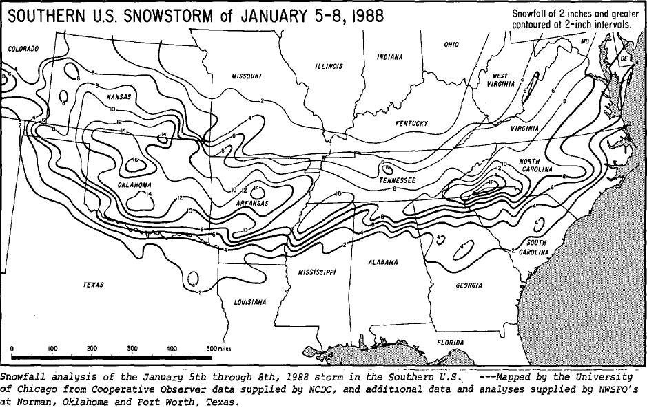
| The storm dumped snow from the southern Rockies all the way across to the mid Atlantic coast. This map shows snowfall totals from the system. (Courtesy NCDC/Storm Data) |
Off and on sleet and freezing rain continued in the Huntsville area into the afternoon hours. Farther north over southern middle Tennessee, most of the precipitation continued to be sleet. Farther south, temperatures warmed enough for the precipitation to change over to rain. In Birmingham, this happened before noon. Temperatures even briefly warmed to 33°F at the Huntsville airport by the early evening hours, but precipitation was light and intermittent at that point. Since the temperature quickly fell back below freezing a few hours later, very little melting took place. The precipitation turned back to all snow for most areas during the late evening hours. Snow showers tapered off overnight Thursday and early Friday morning. Isolated snow showers affected the Tennessee Valley during the day Friday, but there were no additional significant accumulations. Strong winds caused blowing and drifting of snow that was already on the ground.
The majority of the snow and sleet fell overnight Wednesday into Thursday morning. Storm total accumulations ranged from around 2 inches in the Smith Lake area of southern Cullman County to over 10 inches in the far northeast corner of Alabama, with the majority of the area seeing over a half a foot. Parts of Cullman County and far southern Lawrence County saw lesser accumulations due to the majority of the precipitation falling as sleet or freezing rain. Lesser accumulations were reported in Colbert and Franklin counties, where less precipitation fell overall. The highest accumulations took place from the Moulton - Decatur area eastward along the Highway 72 corridor and over northern parts of Sand Mountain and Lookout Mountain. The highest total reported in the NWS Huntsville County
 |
| GOES-6 is shows snow cover over the Tennessee Valley on the morning of January 11th. Click to view the full image. (Courtesy NCDC/Storm Data) |
Warning Area was 10.5" at Bridgeport. Long-time cooperative observer Mr. Crow of Valley Head reported an even 10". Other accumulation reports across the area were: 9.6" at Huntsville Airport, 9.1" at Guntersville, 9" at Moulton and Scottsboro, 8" at Athens and Fayetteville, 7" at Fort Payne, 6.5" at Falkville, 6.3" at Russellville, 6" on Sand Mountain at Crossville, 5.5" at Hanceville, 5" at the Muscle Shoals Airport, and 2.5" in Cullman.
A prolonged period of sub-freezing temperatures after the event allowed snow to stay on the ground across north Alabama and southern Tennessee for several days. At least a trace of snow remained on the ground in Huntsville for nine days after the snow began, with at least a half a foot of snow remaining on the ground for four days. In Fayetteville there was still snow on the ground ten days after the event, and at Valley Head snow was still on the ground after 13 days!
Storm Effects
|
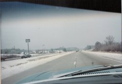
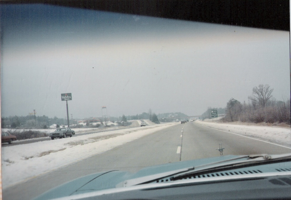
| It was a snowy trip along I-65 in Cullman County. This picture was taken near the Good Hope exit. (Courtesy Mike Wilhelm) |
As is often the case when winter weather is experienced in this area, the snow, sleet, and freezing rain virtually paralyzed the Tennessee Valley. Almost all area roads were closed or too hazardous to travel on. Even some major highways stayed closed for a few days. I-65 was closed from the Tennessee River bridge near Decatur to the Tennessee state line from Thursday until late Saturday. It took crews longer to get to secondary and local roads, and some of those roads were closed or impassable for nearly a week - especially in the higher elevations of Northeast Alabama. The following Tuesday (5 days after the snowfall), some roads on Sand Mountain and in the Paint Rock Valley still hadn't been touched by road crews. Even with moderating temperatures the following week, considerable problems arose across the area as snow that melted during the day would refreeze on roads at night.
|
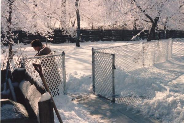
| Residents of northeast Huntsville awoke to a winter wonderland on January 7th. (Courtesy Mike Wilhelm) |
During the event, most flights were delayed or canceled at Huntsville International Airport. Even the usually unstoppable postal service faced a considerable amount of difficulty delivering mail, especially in the more rural areas where roads remained hazardous for several days. Most city and county school systems were closed for at least three school days. Some were closed or delayed for up to five days.
Around a million chickens were killed when the houses they were in collapsed due to snow and ice accumulations. Around a quarter million birds survived, but were not economically salvageable. Damage to poultry houses were estimated to be over $15 million in Cullman, Morgan, Marshall, DeKalb, and Lawrence counties. This prompted Governor Guy Hunt to declare a state of emergency for north Alabama.
Scattered power outages were reported across north Alabama and southern middle Tennessee, but in most places power was quickly restored. Outages were a bigger problem in areas farther south that saw predominately sleet and freezing rain. In some of those areas, power outages lasted for several days.
Additional Pictures
Click on the thumbnail images to see full images.
 |
 |
 |
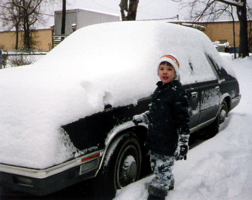
| Snow covers a car in Russellville on the morning of January 7th . (Courtesy Lilly Claude Rooks/Christopher Arthur) |
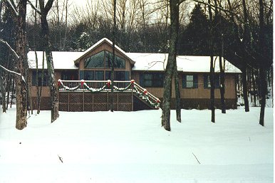
Snow on Monte Sano Mountain in Huntsville. (Courtesy HD Bagley) |
Snow on Monte Sano Mountain in Huntsville. (Courtesy HD Bagley) |
 |
 |
 |
| Snow on Monte Sano Mountain in Huntsville. (Courtesy HD Bagley) |
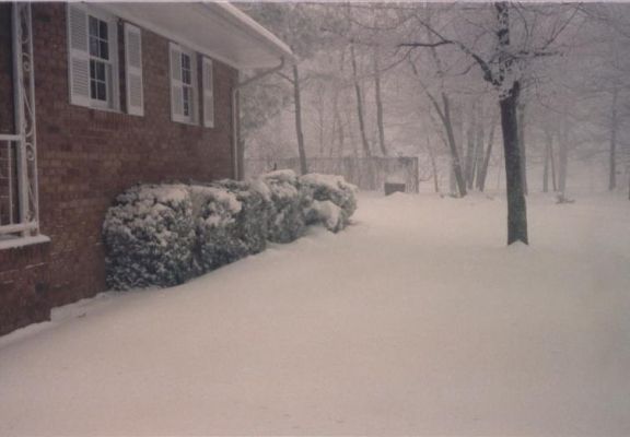
The snow made for a beautiful scene at this home in the Big Cove community east of Huntsville on the morning of January 7th. (Courtesy Rick and Janeil Hill) |
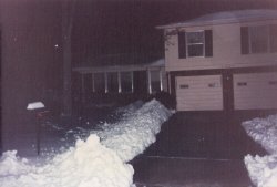
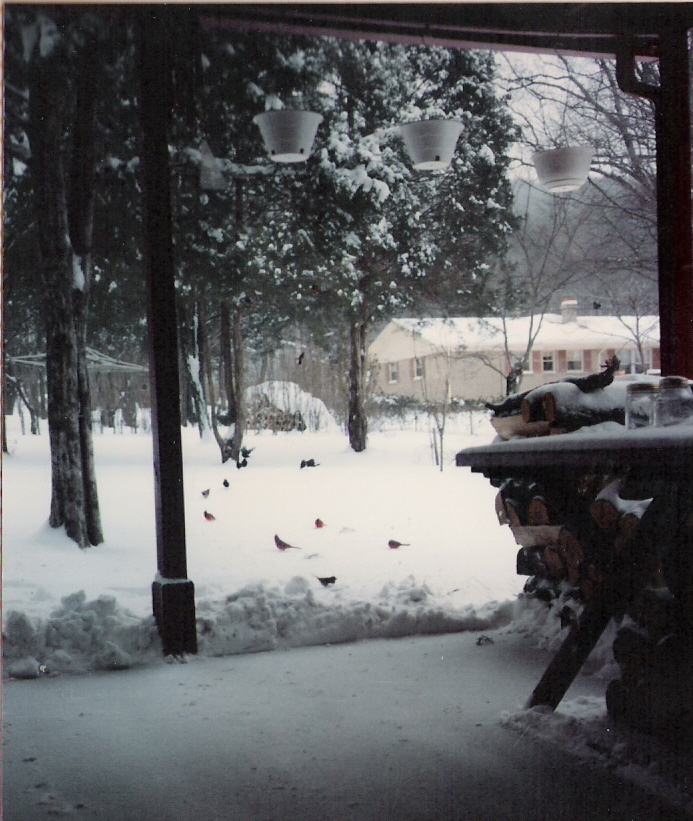
Snow was piled up in this northeast Huntsville yard. (Courtesy Mike Wilhelm) |
 |
 |
|
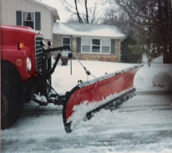
| Huntsville City officials worked to clear snow-covered roadways. (Courtesy Mike Wilhelm) |
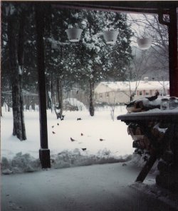
A snow-covered yard in northeast Huntsville. (Courtesy Mike Wilhelm) |
|
Weather Observations
The following are weather observations at the Huntsville International Airport.
| Date |
Time |
Sky Condition/Weather |
Temp (°F) |
Dewpoint (°F) |
Wind (mph) |
Visibility (mi.) |
| 6th |
Midnight |
Broken |
23 |
7 |
N @ 13 |
15 |
| 6th |
1am |
Broken |
22 |
6 |
N @ 12 |
15 |
| 6th |
2am |
Overcast |
22 |
6 |
N @ 14 |
15 |
| 6th |
3am |
Broken |
20 |
7 |
NNE @ 16 |
15 |
| 6th |
4am |
Overcast |
20 |
4 |
NNE @ 14 |
15 |
| 6th |
5am |
Broken |
20 |
4 |
N @ 15 |
15 |
| 6th |
6am |
Overcast |
19 |
4 |
N @ 17 |
15 |
| 6th |
7am |
Overcast |
19 |
4 |
NNE @ 14 |
15 |
| 6th |
8am |
Overcast |
19 |
2 |
N @ 15 |
15 |
| 6th |
9am |
Overcast |
19 |
3 |
NNE @ 13 |
15 |
| 6th |
10am |
Overcast |
20 |
4 |
NNE @ 14 |
15 |
| 6th |
11am |
Overcast |
22 |
4 |
NNE @ 12 |
15 |
| 6th |
Noon |
Overcast |
24 |
3 |
NE @ 10 |
15 |
| 6th |
1pm |
Overcast |
25 |
1 |
NNE @ 14 |
15 |
| 6th |
2pm |
Overcast |
26 |
2 |
N @ 9 |
15 |
| 6th |
3pm |
Overcast |
26 |
1 |
N @ 13 |
15 |
| 6th |
4pm |
Overcast |
27 |
0 |
N @ 12 |
15 |
| 6th |
5pm |
Overcast |
26 |
0 |
NE @ 13 |
15 |
| 6th |
6pm |
Overcast |
26 |
2 |
NNE @ 15 |
15 |
| 6th |
7pm |
Overcast |
26 |
3 |
NE @ 15 |
15 |
| 6th |
8pm |
Overcast |
26 |
4 |
NE @ 14 |
15 |
| 6th |
9pm |
Overcast |
25 |
6 |
NE @ 12 |
15 |
| 6th |
9:35pm |
Overcast/Light Snow |
|
|
NE @ 15 |
3 |
| 6th |
9:57pm |
Overcast/Snow |
|
|
NNE @ 12 |
1/2 |
| 6th |
10pm |
Overcast/Light Snow |
23 |
15 |
N @ 10 |
1 |
| 6th |
10:24pm |
Overcast/Heavy Snow |
|
|
NE @ 15 |
1/4 |
| 6th |
11pm |
Overcast/Heavy Snow |
21 |
20 |
N @ 10 |
1/4 |
| 6th |
11:40pm |
Overcast/Snow |
|
|
NE @ 10 |
1/4 |
| 7th |
Midnight |
Overcast/Heavy Snow |
21 |
19 |
NNE @ 12 |
1/4 |
| 7th |
12:28am |
Overcast/Heavy Snow/Sleet |
|
|
N @ 7 |
1/2 |
| 7th |
1am |
Overcast/Heavy Snow/Sleet |
21 |
19 |
NNE @ 8 |
1/2 |
| 7th |
1:20am |
Overcast/Heavy Snow |
|
|
NE @ 8 |
1/4 |
| 7th |
2am |
Overcast/Heavy Snow |
21 |
20 |
N @ 7 |
1/4 |
| 7th |
2:23am |
Overcast/Light Snow |
|
|
ENE @ 12 |
1 |
| 7th |
3am |
Overcast/Snow |
21 |
20 |
ESE @ 8 |
1/2 |
| 7th |
3:20am |
Overcast/Heavy Snow |
|
|
Calm |
1/4 |
| 7th |
3:40am |
Overcast/Snow |
|
|
ESE @ 12 |
1/2 |
| 7th |
4am |
Overcast/Snow |
23 |
22 |
ESE @ 16 |
1/2 |
| 7th |
4:01am |
Overcast/Light Snow |
|
|
E @ 16 |
1 |
| 7th |
4:39am |
Overcast/Light Snow/Light Blowing Snow |
|
|
E @ 17 |
3/4 |
| 7th |
5am |
Overcast/Light Snow/Light Blowing Snow |
24 |
23 |
E @ 18 |
3/4 |
| 7th |
5:08am |
Overcast/Light Snow/Light Blowing Snow |
|
|
E @ 13 |
1 |
| 7th |
5:30am |
Overcast/Light Snow |
|
|
E @ 15 |
1 1/2 |
| 7th |
6am |
Overcast/Light Snow |
25 |
24 |
E @ 17 |
1 1/2 |
| 7th |
6:15am |
Overcast/Snow |
|
|
ESE @ 16 |
1/2 |
| 7th |
6:39am |
Overcast/Heavy Snow |
|
|
ESE @ 18 |
1/4 |
| 7th |
7am |
Overcast/Heavy Snow |
25 |
24 |
E @ 18 |
1/4 |
| 7th |
7:32am |
Overcast/Snow/Light Blowing Snow |
|
|
E @ 16 |
1/2 |
| 7th |
7:57am |
Overcast/Light Snow/Sleet/Light Blowing Snow |
|
|
E @ 17 |
2 |
| 7th |
8am |
Overcast/Light Snow/Light Blowing Snow |
26 |
25 |
E @ 21 |
3/4 |
| 7th |
8:10am |
Overcast/Light Freezing Rain/Snow/Sleet |
|
|
E @ 18 |
6 |
| 7th |
9am |
Overcast/Light Freezing Rain/Sleet/Fog |
29 |
27 |
E @ 7 |
3 |
| 7th |
10am |
Overcast/Light Freezing Rain/Sleet/Fog |
29 |
27 |
ESE @ 15 |
4 |
| 7th |
11am |
Overcast |
30 |
28 |
E @ 7 |
7 |
| 7th |
Noon |
Overcast |
31 |
28 |
ENE @ 12 |
7 |
| 7th |
12:12pm |
Overcast/Light Freezing Rain |
|
|
ENE @ 10 |
6 |
| 7th |
1pm |
Overcast/Light Freezing Drizzle |
31 |
30 |
N @ 5 |
6 |
| 7th |
1:30pm |
Overcast/Light Freezing Rain/Fog |
|
|
NNE @ 6 |
1 |
| 7th |
2pm |
Overcast/Light Freezing Rain/Fog |
31 |
30 |
NE @ 6 |
1 |
| 7th |
3pm |
Overcast/Light Freezing Rain/Fog |
32 |
31 |
E @ 9 |
1 1/2 |
| 7th |
3:35pm |
Overcast/Light Freezing Rain/Fog |
|
|
NE @ 7 |
1 1/2 |
| 7th |
4pm |
Overcast/Light Freezing Drizzle/Fog |
32 |
32 |
N @ 8 |
1 1/2 |
| 7th |
4:22pm |
Overcast/Light Drizzle/Fog |
|
|
NNE @ 6 |
1 1/2 |
| 7th |
5pm |
Overcast/Light Drizzle/Fog |
32 |
32 |
NE @ 7 |
1 1/2 |
| 7th |
5:07pm |
Overcast/Light Drizzle/Fog |
|
|
NE @ 8 |
1 |
| 7th |
6pm |
Overcast/Light Drizzle/Fog |
33 |
32 |
ENE @ 8 |
1 |
| 7th |
6:17pm |
Overcast/Fog |
|
|
E @ 9 |
1 |
| 7th |
7pm |
Overcast/Light Snow/Fog |
32 |
32 |
E @ 7 |
1 |
| 7th |
7:22pm |
Overcast/Fog |
|
|
E @ 15 |
1 |
| 7th |
7:35pm |
Overcast/Fog |
|
|
ESE @ 12 |
3 |
| 7th |
8pm |
Overcast/Fog |
31 |
30 |
ESE @ 13 |
3 |
| 7th |
9pm |
Overcast/Fog |
31 |
28 |
ESE @ 12 |
3 |
| 7th |
10pm |
Overcast/Light Freezing Drizzle/Fog |
30 |
28 |
E @ 8 |
2 |
| 7th |
11pm |
Overcast/Light Freezing Drizzle/Fog |
29 |
27 |
ESE @ 9 |
2 |
| 7th |
11:26pm |
Overcast/Fog |
|
|
ESE @ 8 |
2 |
| 7th |
11:36pm |
Overcast/Light Snow/Fog |
|
|
ESE @ 9 |
2 |
| 8th |
Midnight |
Overcast/Light Snow/Fog |
29 |
27 |
ESE @ 8 |
2 |
| 8th |
12:40am |
Overcast/Light Freezing Drizzle/Snow/Fog |
|
|
E @ 6 |
2 |
| 8th |
1am |
Overcast/Fog |
29 |
27 |
E @ 6 |
4 |
| 8th |
2am |
Overcast/Fog |
29 |
27 |
ESE @ 6 |
5 |
| 8th |
3am |
Overcast/Fog |
29 |
27 |
Calm |
5 |
| 8th |
3:09am |
Overcast/Fog |
|
|
E @ 4 |
5 |
| 8th |
4am |
Overcast/Fog |
27 |
25 |
NNW @ 4 |
4 |
| 8th |
5am |
Overcast/Fog |
27 |
25 |
NNW @ 6 |
3 |
| 8th |
5:38am |
Overcast/Fog |
|
|
NW @ 9 |
2 |
| 8th |
6am |
Overcast/Fog |
25 |
24 |
NW @ 9 |
2 |
| 8th |
6:32am |
Overcast/Fog |
|
|
NNW @ 12 |
1 1/2 |
| 8th |
7am |
Overcast/Fog |
25 |
23 |
NW @ 9 |
1 1/2 |
| 8th |
7:32am |
Overcast/Fog |
|
|
NNW @ 13 |
1 1/2 |
| 8th |
8am |
Overcast/Fog |
24 |
22 |
NW @ 12 |
1 1/2 |
| 8th |
8:37am |
Overcast/Fog |
|
|
NNW @ 12 |
3/4 |
| 8th |
9am |
Overcast/Fog |
24 |
22 |
NNW @ 12 |
3/4 |
| 8th |
10am |
Overcast/Fog |
24 |
21 |
NW @ 12 |
3/4 |
| |
|
|
|
|
|
|
Feedback
Do you have memories from the 1988 winter storm? If you have stories or photos from the winter storm that you're willing to share with us, we'd love to hear from you! For more information on how to contact us, visit this page.
|


 Local Radar
 Weather Map
 Follow us on YouTube