|
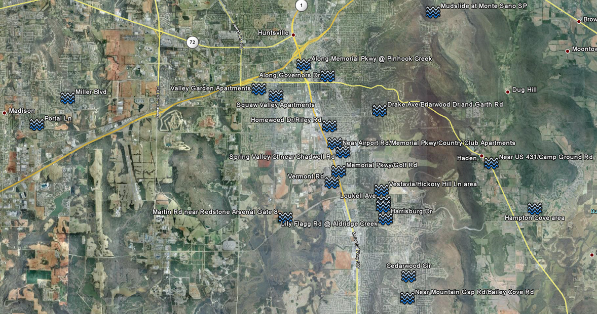
Map of locations where flooding or flash flooding was reported in Madison County on the morning of June 28, 1999. Click for higher resolution image. The early morning hours of June 28, 1999 were very memorable for many residents of south Huntsville. Heavy rain began falling shortly after midnight, and continued for several hours as a line of thunderstorms trained over the same area. Flash flooding began as early as 1:20am, with water submerging cars across central and southern parts of the city. Some residents were trapped in or on their vehicles and had to be rescued. Eventually, water began to enter homes, forcing residents to evacuate. Flooding continued through the early morning hours until rainfall finally tapered off before daybreak. During the event, one person died and one other person was injured. Major flooding occurred along Memorial Parkway from the Clinton Avenue area south to around Byrd Spring Lake. Most notably, a 29 year old woman drowned when her car was overcome by flood waters on Vermont Road. As she tried to escape from the car, she was washed away. Significant problems also occurred along Memorial Parkway at Airport Road. There, major flooding occurred in the vicinity of the Taco Bell and the Firestone Auto Care store. Water poured into several lower-level units at the Country Club Apartments. Though all of the apartment residents were able to escape the rising water, a few of them were shocked as flood waters made contact with electronics in their dwellings. Only one person required medical attention for electrical shock. In the same area, a television reporter was caught in flood waters when he stepped into a ditch. A woman spotted him, and he was rescued by Huntsville firefighters. Perhaps the hardest hit area in Huntsville was the Aldridge Creek flood plain in the southeast part of the city. As runoff poured into the small creek, it was quickly overwhelmed and water poured out of its banks. As a result, several adjacent roads, homes, and businesses were flooded. Areas along the creek as far north as Drake Avenue were affected. There, major asphault damage occurred on Drake Avenue at Briarwood Drive and at Garth Road. Farther downstream in Jones Valley, water damaged parts of the Mayfair Church of Christ. Numerous homes were flooded along Hickory Hill Lane, including homes on Vestavia Circle. Homes were also flooded along Loukell Avenue, Harrisburg Drive, and Lily Flagg Road. Even farther downstream in far southeast Huntsville, water approached homes on Cedarwood Circle, and flooded residences near the intersection of Mountain Gap Road and Bailey Cove Road. Additional flooding was reported elsewhere around the county. In Madison, watered covered a few roads, and even entered one house along Portal Lane. In Owens Cross Roads, a man had to be rescued from his truck when it became submerged in water. Also, a mudslide covered portion of a park road on Monte Sano Mountain. Flooding was also reported in the Big Cove and Hampton Cove areas east of Huntsville. In total around 300 homes and businesses were flooded in the Huntsville area, resulting in around $7 million worth of damage. It was the worst flooding in the city since March of 1973. As a result, a major flood mitigation project ensued. Aldridge Creek was widened in several areas, and homes were removed from the creek’s flood plain.
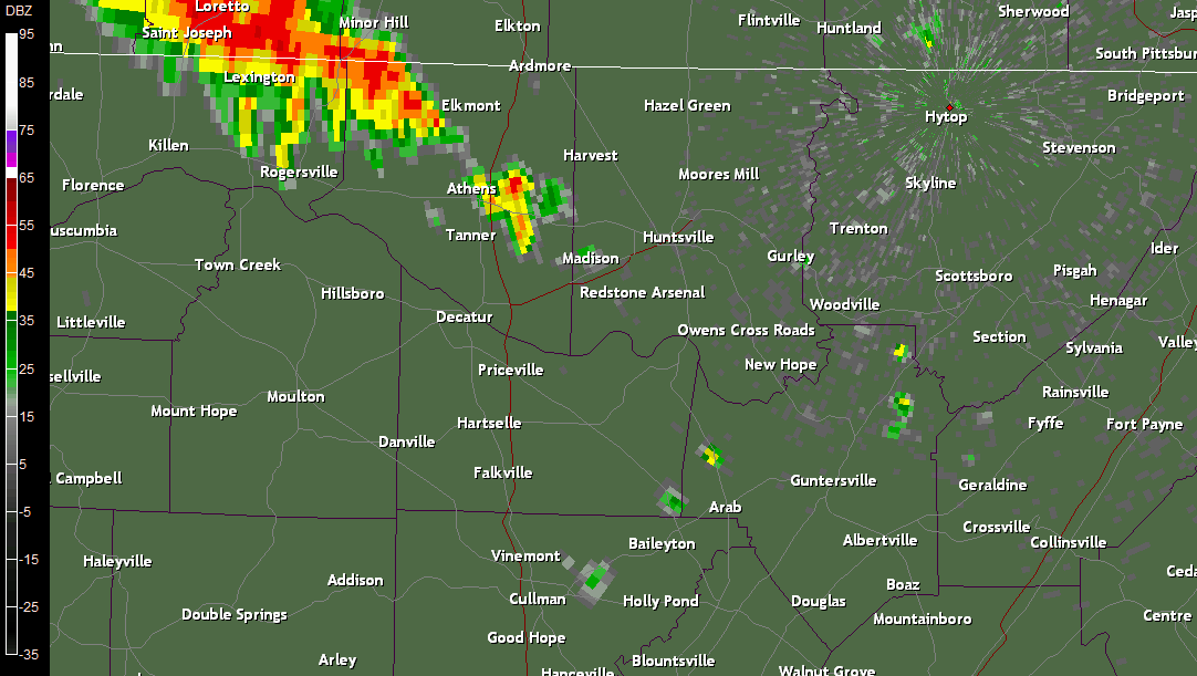
This National Weather Service radar image from around 2am on June 28, 1999 shows heavy rain affecting areas from eastern Lauderdale County through southern Madison County. Click on this image for a radar animation between 12:30am and 5:15am, when the heaviest rain was occurring in south Huntsville.
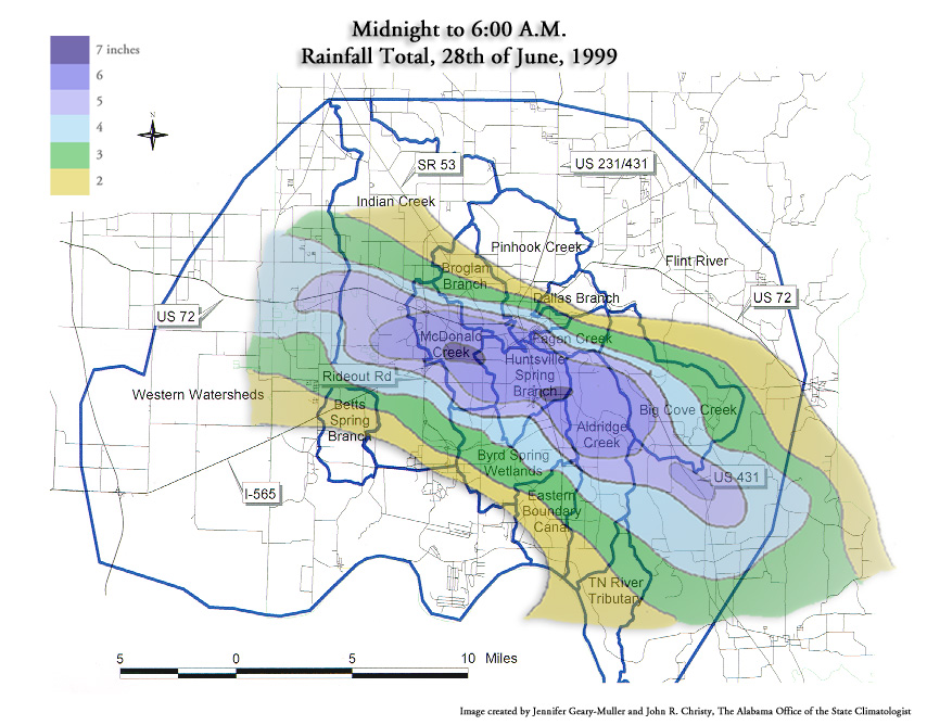
Area Rainfall Totals Below is a listing of rainfall totals from June 28, 1999. Note the high discrepancy in rainfall accumulations between gauges in south Huntsville and gauges in north Huntsville. Many of these rainfall totals are courtesy of Alabama State Climatologist Dr. John Christy. Note: Two automated gauges located in the area of heaviest rainfall (along Aldridge Creek near Farley and along McDonald Creek at Patton Road) were damaged by flood waters and flood debris, thus reliable rainfall data is unavailable from these locations.
Rainfall accumulation amounts for the Huntsville area between midnight and 6 am on June 28th 1999. Amounts based on a combination of ground-truth observations and modified radar accumulation estimates. Map created by Alabama Climatologist Dr. John Christy and Jennifer Geary-Muller of the Alabama Office of the State Climatologist. Click image for full size.
Huntsville wasn’t the only area affected by flash flooding that morning. Heavy rain in the Shoals lead to flash flooding in Lauderdale and Colbert counties. In Greenhill, a few automobiles were washed off the roadway by flood waters. Thankfully, no one was injured. Flooding also occurred along Shoal Creek in Lauderdale County. And in Muscle Shoals, several roads and businesses were flooded. Meanwhile on Sand Mountain, heavy rains flooded small creeks and streams in the Boaz area. Some roads had to be temporarily closed due to flood waters. Minor flooding was also reported in Franklin County, Tennessee.
Do you have memories from the flash floods of June 1999? If you have stories or photos from the flood that you're willing to share with us, we'd love to hear from you! For more information on how to contact us, visit this page. |


 Local Radar
 Weather Map
 Follow us on YouTube