|
Early on December 16, 2000, forecasters were trying to determining the impact an approaching cold front would have on the southeastern U.S. The biggest threat was expected over Alabama and Mississippi, in vicinity of a mid-level dry slot rounding base of a trough over the Mississippi River Valley. At 10:00 a.m., the Storm Prediction Center issued a tornado watch for western, central, and northern Alabama and eastern Mississippi, effective until 4:00 p.m. that afternoon. This watch area came to the Tennessee line, putting extreme southern middle Tennessee on notice for the potential for severe weather as well. The specific area was 95 statute miles east and west of a line extending from 65 miles southeast of Laurel, MS to 25 miles northeast of Muscle Shoals, AL. Again, the impact of a speed maximum over central Texas moving eastward into the area during the day was highlighted, along with expectations of "deep layer shear, on the order of 55 knots." As expected, the greatest magnitude of severe weather on December 16 occurred south of Tennessee, including a deadly and unusually strong cold season tornado (F4) at Tuscaloosa, AL. |
||||
|
||||
|
Limestone and Lawrence County Tornadoes |
||||
|
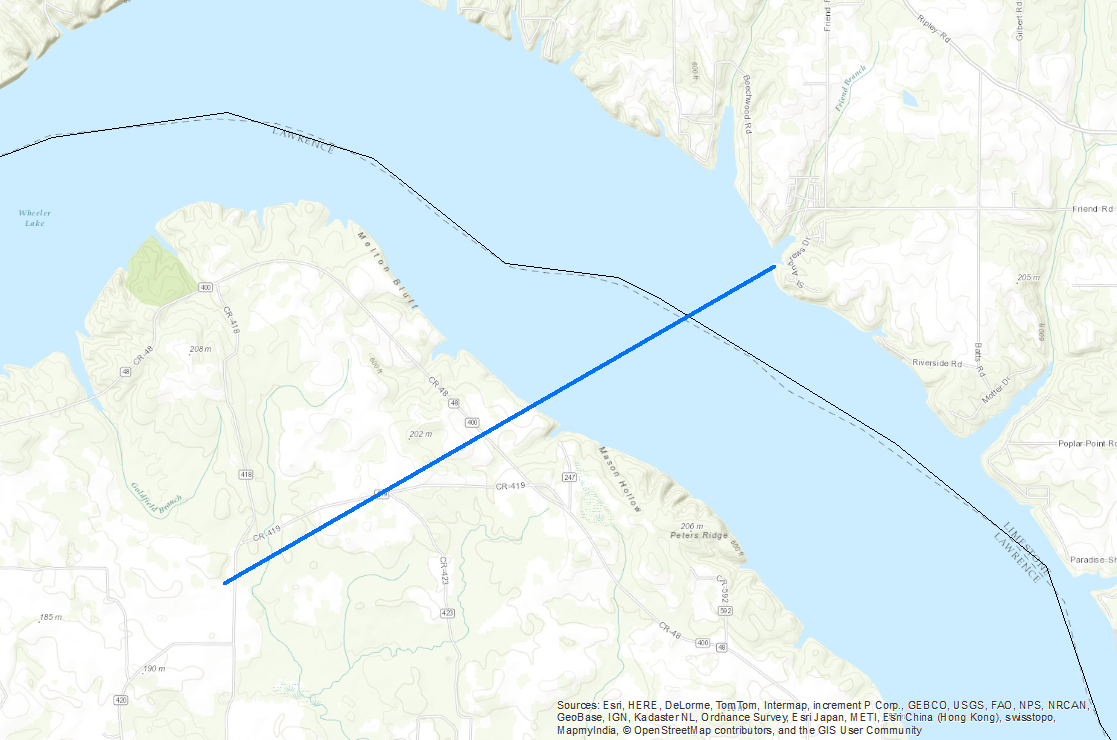
Meteorologists from the National Weather Service office in Birmingham conducted a storm survey in Lawrence and Limestone Counties and identified two tornado tracks in Limestone county. Damage in Lawrence was initially believed to be caused by strong straight wind with thunderstorms on the 16th, but later was found to be associated with the tornado track crossing the Tennessee River near Wheeler Dam. COUNTY TORNADO NEAR COXEY The first tornado in Limestone County touched down in northeastern Lawrence county before crossing the Tennessee River and touching down on the northern bank of the river about 2.9 miles south of Coxey in southwest Limestone County. The tornado travelled approximately a half mile before dissipating rapidly. One house lost a portion of a roof, two other homes sustained damage from falling trees, several boat houses and out-buildings were destroyed, and numerous large trees were downed. The tornado occurred at 12:30 PM and ended by 12:31 PM and was rated an F1 on the Fujita Scale for tornado classification. No injuries were reported with this tornado whose track was half a mile long and about 40 yards wide. Click on map in Figure 2 below to see the a zoomed track of this tornado. |
||||
|
||||
|
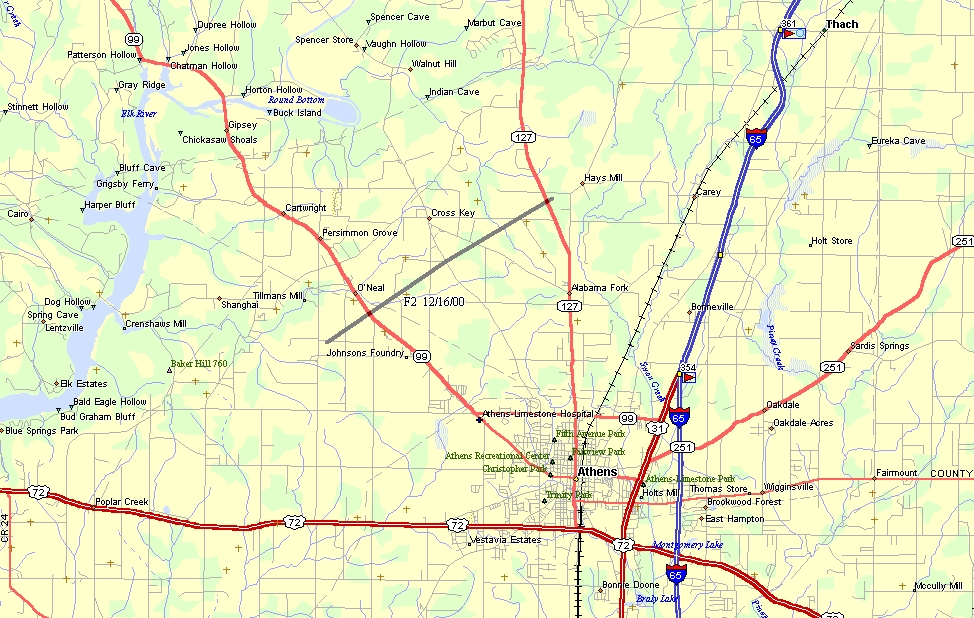
ATHENS TORNADO The second tornado began 5.1 miles west-northwest of Athens just south of O'Neal. The tornado travelled in a northeasterly direction crossing SR 99 where several houses were damaged heavily. Continuing northeast the tornado crossed CR 63 and damaged several houses and destroyed three mobile homes just south of cross key. The tornado then crossed CR 26 and SR 127 before dissipating about 5.0 miles north of Athens. The tornado that moved out of northern Alabama into southern middle Tennessee early in the afternoon was weakening rapidly. However, damage did occur in Limestone County, AL before the tornado moved into Lincoln County, TN. The track for this tornado can be seen below. |
||||
|
||||
|
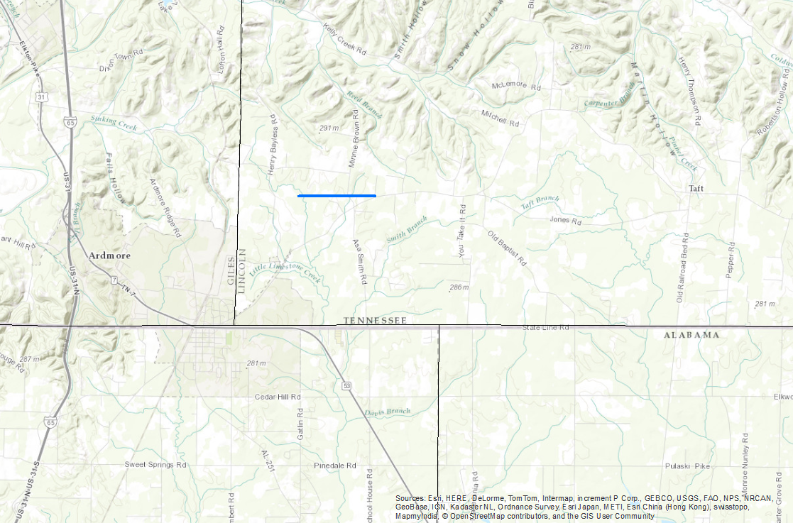
Warnings issued by the Birmingham WFO and numerous ham/spotter reports gave outstanding ground truth to the radar images. As this storm continued to move northeast into Lawrence County, TN, Skywarn Spotters relayed several reports of another tornado touchdown with this storm. The Middle Tennessee Skywarn Net provided outstanding spotter reports. The Doppler radar in northeast Alabama provided excellent coverage of this storm while in Limestone County, and the WFO in Birmingham significantly aided in the warning process when they called Nashville to report a "confirmed tornado on the ground," headed toward southern middle Tennessee. LINCOLN COUNTY, TN TORNADO A tornado warning was issued for southeastern Giles County and western Lincoln County, in southern middle Tennessee, at 12:42 p.m., while the tornado was still 15 to 20 minutes away. A call was placed to the Lincoln County sheriff's office at the same time to alert them that a confirmed tornado would be crossing over Interstate 65, near Ardmore, shortly. In addition, the communities of Dell Rose, Elkton, and Cash Point were mentioned in the text of the tornado warning as being in the path of the storm. The actual track can be seen below. |
||||
|
||||
|
Damage was reported just into Lincoln County north of Cash Point and State Highway 110 at approximately 1:05 p.m. Warning lead time for this tornado was close to 25 minutes. A small mobile home was damaged extensively near the initial touchdown location. (See Figure 4) Other roof damage occurred within a quarter mile of the mobile home. A few trees were uprooted near the mobile home. The tornado appeared to lift and move to the northeast just over one mile. Some tree damage occurred over that mile but seemed to be only in the crowns of the trees. At the one mile mark a small outbuilding was destroyed along with several large limbs broken out of trees. The tornado skipped over an elementary school (location of a warning siren), and then caused more roof damage. The tornado tore several shingles off a fairly new house. Just over a tenth of a mile further, the tornado picked up the roof of a cinder block garage and turned it approximately 90 degrees before setting it back down. (See Figure 5) |
||||
|


 Local Radar
 Weather Map
 Follow us on YouTube