| Storm surveys have been completed examining storm damage that occurred on Thursday, May 8th. Information found in these surveys is described below. All tornado ratings are using the Enhanced Fujita Scale. |
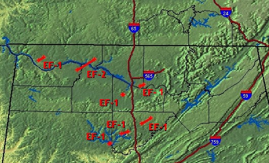 |
| Lauderdale (Oakland; EF-1) |
Colbert/Lawrence/Lauderdale (EF-2) |
| Limestone/Madison (EF-) |
Cullman (EF-1's) |
| Morgan (EF-1) |
|
|
| |
| Southeastern Limestone/Southwestern Madison County |
| Rating |
EF-1 |
Peak Wind |
100 mph |
| Path Length |
2.6 miles |
Peak Path Width |
250 yards |
|
|
Sporadic minor tree and crop damage was observed in the vicinity of County Line Road just north of the Tennessee River, with the most significant damage was observed north of the Blackwell Swamp area within the Wheeler Wildlife Refuge. Grass and wheat patterns suggested a small area of convergent rotation in extreme southeastern Limestone County near New Hope Road. A larger area of grass and wheat was flattened along County Line Road, where minor tree damage and roof damage to one residence was also noted. On the north end of the Blackwell Swamp east of County Line Road, there were larger areas of tree damage, with many pine trees snapped or uprooted.
|
 |
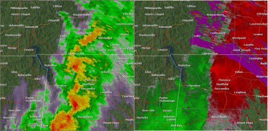
| This National Weather Service radar image from 2:31pm shows strong rotation just southeast of Mooresville in Southeastern Limestone County. The base reflectivity product in the left panel shows rainfall intensity. The storm relative velocity product in the right panel shows winds toward (in green) and away (in red) from the radar in Hytop, AL. |
 |
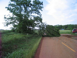 |
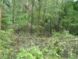
| The tornado caused minor tree damage near County Line Road in Madison County. |
Minor tree damage caused by the tornado near Triana. |
 |
 |
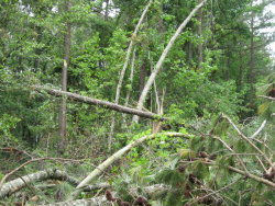
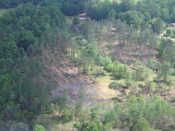
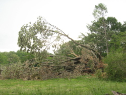
| Damage to pine trees within the Wheeler Wildlife Refuge near Blackwell Swamp was extensive. |
A large area of tree damage on the north end of the Blackwell Swamp. |
|
| |
| Central Lauderdale County |
| Rating |
EF-1 |
Peak Wind |
90 mph |
| Path Length |
5.6 miles |
Peak Path Width |
200 yards |
|
|
A tornado touched down near County Road 189 west of Oakland. EF-1 damage was observed at the intersection of County Roads 14 and 16, about 2 miles northwest of Oakland, extending northeast to the Central Heights area. The tornado produced moderate damage to five homes and uprooted several trees in its path. The path of the tornado began 2 miles northwest of Oakland and lifted in the Central Heights area.
|
 |
| This National Weather Service radar image from noon shows strong rotation northwest of Florence near Central Heights. The base reflectivity product in the left panel shows rainfall intensity. The storm relative velocity product in the right panel shows winds toward (in green) and away (in red) from the radar at Columbus Air Force Base, MS. |
 |
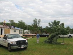 |
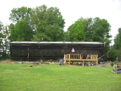
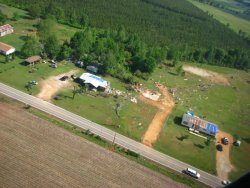
| This mobile home was flipped by the tornado that moved through the Oakland/Central Heights area. |
The tornado caused mostly minor damage to a few homes and downed some large trees. |
|
| |
| Northeast Colbert/Eastern Lauderdale/Extreme Northeast Lawrence |
| Rating |
EF-2 |
Peak Wind |
125 mph |
| Path Length |
9.6 miles |
Peak Path Width |
250 yards |
|
|
The tornado path began in the Leighton community. Shortly after its touchdown, the tornado was captured on a surveillance camera from an equipment company northeast of Leighton captured a tornado picking up at least 2 cars and throwing them nearly 40 feet. The tornado continued northeast snapping and uprooting large trees near Fosters Mill, along County Road 40. Just to the northeast of Fosters Mill, significant structural damage occurred at the Doublehead Resort and Lodge. A two-story house was completely lifted off its foundation and moved nearly 20 feet. The entire west facing side of this house was ripped off and significant roof damage occured. Additional sporadic damage occurred to a garage and other large trees from Joe Wheeler State Park to Rogersville, where the tornado lifted.
|
 |
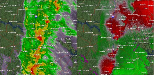
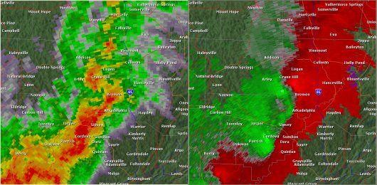
| This National Weather Service radar image from 12:46pm shows strong rotation over northeastern Colbert County between Leighton and Rogersville. This was the approximate time the tornado was at EF-2 strength. The base reflectivity product in the left panel shows rainfall intensity. The storm relative velocity product in the right panel shows winds toward (in green) and away (in red) from the radar at Columbus Air Force Base, MS. |
 |
 |
| Shortly after touching down, the tornado passed near this equipment company. Surveillance equipment captured dramatic footage of the tornado tossing cars around this parking lot. |
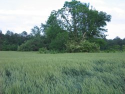
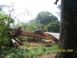
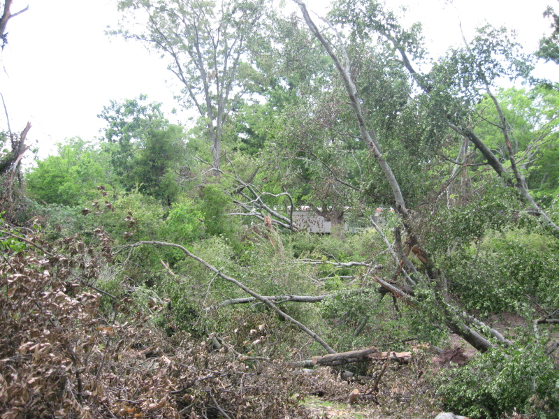
Several large trees were downed along the path of the tornado. |
 |
 |
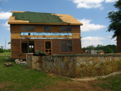
| This home at the Doublehead Resort in northwestern Lawrence County was pushed off its foundation. An entire wall on the side of the house was removed by the tornado. |
This tornado continued to produce sporadic damage after crossing the Tennessee River into Lauderdale County near Rogersville. |
|
| |
| Cullman County |
| Rating |
EF-1 |
Peak Wind |
100 mph |
| |
|
Peak Path Width |
100 yards |
|
|
There were three distinct tornado tracks that were non-continous and developed from the same parent thunderstorm. Each tornado was found to be an EF-1 with path widths of 100 yards.
The first tornado affected locations 3 miles in and around Smith Lake. The second tornado occured from 7 miles from Sulpher Springs to Trimble. The third tornado track occured 5 miles from east of Cullman to Simcoe.
Predominantly tree damage was observed, with many trees snapped and uprooted, including several large old oak trees just to the east of the city of Cullman. The most severe damage occurred northeast of Cullman at a pair of chicken houses. One chicken house completely collapsed and the central portion of the structure was twisted and gnarled. It also had its metal roofing torn and twisted in the fields nearby. In addition, pockets of straight line wind damage were noted south of the tornado tracks, including within southern portions of the city of Cullman.
|
 |
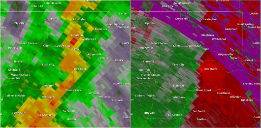
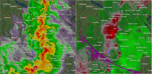
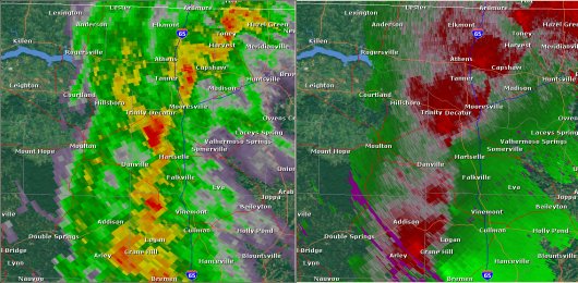
| This National Weather Service radar image from 2:14pm shows strong rotation over western Cullman County just south of Crane Hill. This was around the time the second tornado touched down. The base reflectivity product in the left panel shows rainfall intensity. The storm relative velocity product in the right panel shows winds toward (in green) and away (in red) from the radar in Shelby County, AL. |
 |
| This National Weather Service radar image from 2:50pm shows strong rotation over northeastern Cullman County between Cullman and Baileyton. This was around the time the third tornado touched down. The base reflectivity product in the left panel shows rainfall intensity. The storm relative velocity product in the right panel shows winds toward (in green) and away (in red) from the radar in Hytop, AL. |
 |
 |
| The first of the three tornadoes crossed into Cullman County from Walker County. In this image, you can see several trees downed near Smith Lake. |
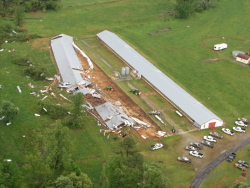
These chicken houses in northeastern Cullman County were destroyed by the tornado. The one on the left was blown apart. Though the one on the right may appear to be in tact, it was actually found to be structurally unsound. Image courtesy Cullman County EMA. |
 |
 |
| A tree fell on the roof of this apartment complex, nearly splitting it in half. Image courtesy Cullman County EMA. |
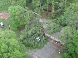
Extensive tree damage occurred across Cullman County with all three of the tornadoes. |
|
| |
| West-Central Morgan County |
| Rating |
EF-1 |
Peak Wind |
95 mph |
| Path Length |
0.86 miles |
Peak Path Width |
50 yards |
|
|
A tornado touched down in the vicinity of Norris Mill Road, northwest of Hartselle, where extensive tree damage was observed over a relatively short distance and width. Multiple medium to large trees were uprooted, including a 4-foot diameter tree, and several smaller trees and large branches were snapped.
|
 |
| This National Weather Service radar image shows a broad area of rotation northwest of Hartselle. The base reflectivity product in the left panel shows rainfall intensity. The storm relative velocity product in the right panel shows winds toward (in green) and away (in red) from the radar at Hytop, Alabama. |
 |
 |
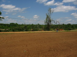
| The most extensive tree damage was observed off Macabee Drive, where many trees fell in a convergent pattern. |
The tornado toppled a 4-foot diameter tree off Goose Pond Road and snapped off several medium to large branches. |
| |


 Local Radar
 Weather Map
 Follow us on YouTube