|
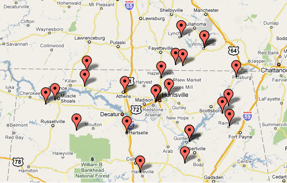
Widespread wind damage occurred across Northern Alabama and Southern Middle Tennesseee. Below is a plot of these damage reports.
|
|
Recap of Event |
|
On Thursday morning (December 24, 2009), a complex and potent weather system was developing across eastern Texas, northwestern Lousisana, and southwestern Arkansas. A 996 mb low pressure system had developed along a cold front which extended southward from the Minessota and North Dakota border through western Missouri. A warm front extended southeast from this low through northern Louisiana and Mississippi. Below is a surface analysis from 6 am on Thursday morning.
|
|
The strongest moisture transport and forcing through much of the day existed in the vicinity of these frontal boundaries. This was facilitated by the development of a 40 kt to 50 kt (46 mph to 58 mph) 850 mb jet streak over eastern Texas and Louisana, as seen here. This produced heavy rainfall across Arkansas, Missouri, and Mississippi. A dry air mass was in place across northern Alabama and portions of southern middle Tennessee at 7 am, with dewpoints in the lower to mid 30s. This was due to the strong high pressure system in place over Virginia and North Carolina. This dry air is depicted by the separation of temperature and dewpoint lines found on the 12Z sounding from BMX shown below.
|
|
As the day progressed, the low pressure system pushed further north northeast into western Arkansas while deepening to less than 992 mb. The eastward progression of this developing cyclone was being impeded by high pressure to the northeast of the system. This created a pressure gradient which produced sustained winds between 25 and 35 mph with gusts to around 45 mph by the mid to late morning hours across northern Alabama. The suface high remained in place over Virginia intensifying the strength of the low level wind field on Christmas Eve. The 850 jet streak(wind speed maximum) shifted eastward over northern Alabama and increased to between 60 and 70 kts (69 mph to 81 mph) by 6 pm on Christmas Eve. This can be seen in the image below and is denoted by the area enclosed by the orange line.
This produced gusts over 50 mph during the late afternoon and evening hours. The winds blew down numerous trees across northern Alabama. Some roofs of homes were damaged by these wind gusts. The storm system and it's associated cold front pushed rapidly northeast into southeastern Iowa by 6 am on Christmas morning (while deepening significantly to 987 mb).
This brought an end to the extremely high winds as the jet streak pushed north and east of the area. |
|
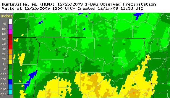
Rainfall Across the Huntsville Forecast area Moderate to heavy rainfall was reported ahead of this cold front in northern Alabama. This resulted in accumulations between 0.75 and 1.5 inches across much of northern Alabama. Even heavier rain occurred in Cullman county where between 1.5 and 2.5 inches fell. Below is an image of the accumulated precipitation from 7 am on the 24th through 7 am on the 25th.
|


 Local Radar
 Weather Map
 Follow us on YouTube