|
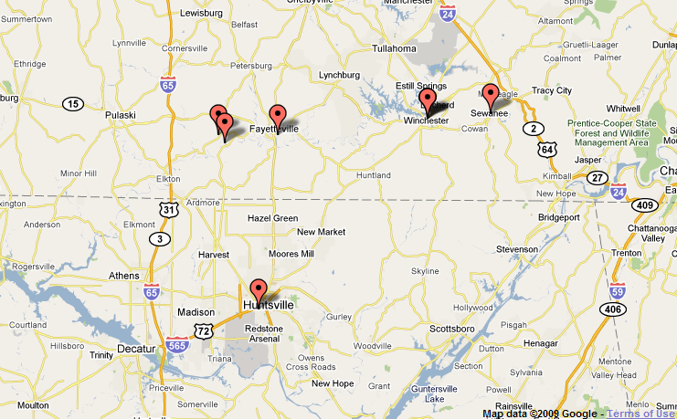
Event Summary During the early afternoon hours of Thursday, January 21, 2010, scattered showers and thunderstorms developed across portions of north Alabama and southern middle Tennessee. By the late afternoon and early evening hours, a few of the storms began to strengthen to severe thresholds, especially over middle Tennessee. Large hail was reported across Lincoln and Franklin counties, with hail as large as baseballs being reported in the city of Fayetteville. Around 5pm, a thunderstorm in Franklin County, Tennessee produced an EF-1 tornado just east of the town of Sewanee. Around the same time, a strong thunderstorm producing heavy rainfall and small hail was moving across southwest Madison County over the city of Madison and western portions of Huntsville. As the storm began to move across the city of Huntsville, a rotating wall cloud developed over southwestern Madison County. At 5:17pm, a tornado touched down over the northern part of Redstone Arsenal. The tornado nearly paralleled I-565 to the south, passing over Memorial Parkway, northern sections of downtown Huntsville, and Five Points before dissipating as it moved up Chapman Mountain. For more details about this severe weather event, including storm survey information, radar images, pictures, and videos, visit the sections below. |
||||
|
||||
|
Storm Reports
|
||||
..TIME...   ...EVENT...      ...CITY LOCATION...     ...LAT.LON...
..DATE...   ....MAG....      ..COUNTY LOCATION..ST.. ...SOURCE....
            ..REMARKS..

0415 PM     HAIL             10 W FAYETTEVILLE       35.15N 86.74W
01/21/2010  E1.00 INCH       LINCOLN            TN   PUBLIC

            QUARTER HAIL.

0419 PM     HAIL             9 W FAYETTEVILLE        35.13N 86.72W
01/21/2010  M1.75 INCH       LINCOLN            TN   EMERGENCY MNGR

            GOLF BALL HAIL

0436 PM     HAIL             WINCHESTER              35.19N 86.11W
01/21/2010  E1.00 INCH       FRANKLIN           TN   EMERGENCY MNGR

            QUARTER HAIL MIXED WITH PEAS

0436 PM     HAIL             FAYETTEVILLE            35.15N 86.56W
01/21/2010  E2.75 INCH       LINCOLN            TN   PUBLIC

            BASEBALL HAIL MIXED IN WITH GOLF BALLS.

0443 PM     HAIL             WINCHESTER              35.19N 86.11W
01/21/2010  E1.00 INCH       FRANKLIN           TN   PUBLIC

            QUARTER HAIL

0445 PM     HAIL             WINCHESTER              35.19N 86.11W
01/21/2010  E0.88 INCH       FRANKLIN           TN   PUBLIC

            DIME AND NICKEL HAIL COVERING GROUND

0500 PM     TORNADO          2 ENE SEWANEE           35.21N 85.89W
01/21/2010  F1               FRANKLIN           TN   NWS STORM SURVEY

            TORNADO TOUCHED DOWN NEAR THE SEWANEE AIRPORT SNAPPING
            AND UPROOTING TREES. MINOR DAMAGE TO HOMES WAS OBSERVED
            ALONG LEAKY POND LANE. ALONG OTTER FALLS LANE IN THE
            MIDWAY COMMUNITY...A HOME SUSTAINED SIGNIFICANT DAMAGE
            WHEN THE CARPORT WAS DESTROYED AND THE CHIMNEY WAS
            DESTROYED BY FLYING DEBRIS. THE TORNADO CONTINUED TO MOVE
            NORTHEAST PRODUCING MINOR DAMAGE TO HOMES ALONG WITH
            SPORADIC TREE DAMAGE BEFORE MOVING INTO MARION COUNTY.

0517 PM     TORNADO          HUNTSVILLE              34.73N 86.59W
01/21/2010  F2               MADISON            AL   NWS STORM SURVEY

            *** 3 INJ *** AN EF-2 TORNADO TOUCHED DOWN OVER REDSTONE
            ARSENAL...LIFTED...THEN TOUCHED DOWN AGAIN NEAR THE
            INTERSECTION OF TRIANA BLVD AND 9TH AVE...AND TRACKED
            4.4 MILES NORTHEAST BEFORE LIFTING NEAR THE INTERSECTION
            OF GABOURY LN AND ROSALIE RIDGE RD. BOTH SOFT AND
            HARDWOOD TREES WERE SNAPPED...AS WERE WOODEN UTILITY
            POLES. MULTIPLE HOMES SUSTAINED SUBSTANTIAL ROOF DAMAGE
            BOTH FROM FALLING TREES AND TORNADIC WINDS.
|


 Local Radar
 Weather Map
 Follow us on YouTube