A cold front moved across the eastern Carolinas on March 11, 2017, replacing what been several days of temperatures in the 70s with much colder Canadian air. Low pressure developed along the front offshore, throwing moisture back over the top of the cold air. This led to rain developing early in the morning of March 12th, which changed to snow where temperatures were cold enough. Snow fell as far south as Carolina Beach, Bolivia, and Whiteville, NC, and on westward to Columbia, SC. Although the most impressive snowfall totals occurred from Monroe and Charlotte up into the mountains, totals of 1.5 to 2 inches were reported in Lumberton and Castle Hayne, NC.
|
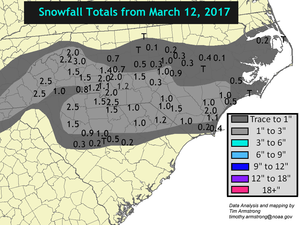
Map of snowfall totals from the March 12, 2017 snowstorm across North and South Carolina. This was the first measurable March snow in Wilmington since March 25, 1983. |
The low pressure system that produced this snow was very weak with a central pressure dropping only to 1016 millibars or 30.00 inches of Mercury. The low developed along the Florida east coast near Jacksonville and moved directly east into the open Atlantic. A strong jet stream extending from Virginia to off the New England coast helped lift the air across the Carolinas.
|
GOES-13 infrared satellite loop of the storm system that brought snow to the Carolinas on March 12, 2017. Colder, thicker clouds are colored blue; warmer, lower clouds are gray. |
Composite radar loop showing precipitation that fell across the Carolinas on March 12, 2017. Precipitation was all-rain south of Wilmington, NC; Conway, SC; and Florence, SC. |
Why did snow fall only across North Carolina and parts of South Carolina? The answer has to do with how far the below-freezing air was able to move southward. Shown below is a cross-section (from the ARW-WRF model) of how temperatures in the atmosphere appeared during the morning of March 12th along a line from New Bern, NC on the left to Charleston, SC on the right. A layer of above-freezing air as much as 7,000 feet thick covered most of coastal South Carolina, while across coastal North Carolina the entire atmospheric column was below freezing. Snowflakes forming in the very cold and humid air 2 to 4 miles up were able to survive the trip down to the ground across Wilmington and New Bern, but as they fell over coastal South Carolina they melted shortly after encountering that thick layer of warm air.
|
|
Local Photos
|
Daffodils covered in snow in Wilmington on March 12, 2017 |
A Ruby-throated Hummingbird was still able to feed on this snow-covered feeder in Wilmington on March 12, 2017. |
|
A snow measurement taken around noon on March 12th in the Kings Grant neighborhood in Wilmington revealed around one inch had fallen. |
Very warm weather in January and February meant many trees and bushes were blooming two weeks or more earlier than normal. This peach tree wasn't affected by the snow, but was damaged by a hard freeze just a few nights after this picture was taken. |
Research & Page Author: Tim Armstrong
Page Created: December 20, 2017
Last Updated: December 20, 2017


 Coastal Flood
  Follow us on YouTube