An arctic blast brought the earliest snow flurries on record to portions of the eastern Carolinas on November 10, 2025. Snow was observed falling during the evening hours in numerous locations including Pembroke, Bladenboro, Elizabethtown, Whiteville, Lake Waccamaw, Marion, Dillon, Leland, Myrtle Beach, and Wilmington.
A CoCoRaHS observer located 9 miles southeast of Lumberton, NC reported a snowfall measurement of 0.1 inches. Public reports received via social media revealed small accumulations of snow also occurred in Lumberton, Cerro Gordo, and Fairmont, NC.
|
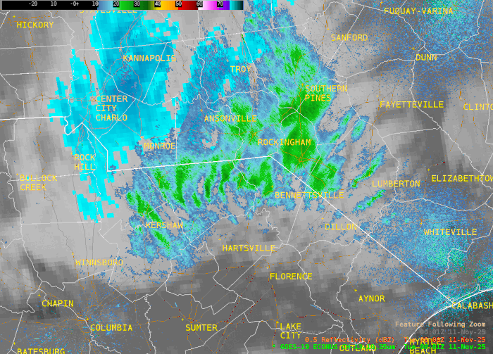
Radar and satellite animation of snow falling across the eastern Carolinas during the evening of November 10, 2025 |
The southernmost report of snow flurries was received from a retired NWS employee in the Burgess community several miles west of Garden City, SC.
Unusually cold weather accompanied the snow with low temperatures in the upper 20s to around 30 degrees reported across the area. Sub-freezing temperatures occurred all the way down to the beaches, accompanied by winds occasionally gusting to 30 mph.
Some videos of the snow shared on social media:
|
Lake Waccamaw, NC from Trish Arthur |
Lumberton, NC from Leslie Lowery |
|
Marion, SC from Karen Coleman |
Bladenboro, NC from Tabitha Dowless |
|
Leland, NC from Carrie Lynn |
Wrightsville Beach, NC from WECT TV News |
Whiteville, NC from WECT TV News |
This snow was the result of a very strong upper level trough moving across the Carolinas. This disturbance originated over the southern tip of Hudson Bay, Canada on November 8 and moved southward across the Great Lakes on November 9 before sweeping eastward across the Carolinas on November 10. Weather systems like this aren't uncommon during mid-winter, but are very rare this early in the cool season.
Air temperatures measured by a weather balloon about 10,000 feet above Greensboro during the evening of November 10 (00z Nov 11) revealed a 700 millibar air temperature of -18°C, the coldest measured so early in the season at Greensboro according to the SPC Sounding Climatology resource. A common forecasting rule-of-thumb is that snow crystals will most easily form when air temperatures are between -12° and -18°C, a region known as the dendritic growth zone. Meager moisture carried southward along with the disturbance from Canada was efficiently converted to snow by these very cold temperatures aloft.
|
500 millibar hourly analysis showed a very strong upper level trough passing across the Carolinas during the evening of November 10, 2025. A narrow zone of ascent just ahead of the trough axis pushed across the area between 8 pm and midnight (01z to 04z Nov 11) which supported snow. |
Snowfall amounts over 5 inches were reported from Mitchell County in the mountains of North Carolina with light trace amounts extending eastward across the Piedmont region including Charlotte.
In Wilmington, this was the earliest snow has ever been observed since local weather records began in April 1871. Trace of amounts of snow had been recorded only a few times in mid-November in Wilmington's history including Nov 12-13, 2013; Nov 14, 1976; and Nov 14, 1934. The earliest measurable snow in Wilmington's history remains 1.5 inches which fell on Nov 20, 1879.
In Lumberton, NC, the 0.1 inches that fell appears to have been the earliest measurable snow on record, beating the previous snow that occurred on November 25, 1950.
Additional local snowfall history and climatology is available on our Wilmington Snowfall Database and Lumberton Snowfall Database pages.
Research and Page Author: Tim Armstrong
Last Updated: November 11, 2025


 Coastal Flood