National Weather Service United States Department of Commerce

Overview

On April 19, 1996, Illinois experienced its largest tornado outbreak on record. A total of 39 tornadoes were observed across the state.

One particular supercell in central Illinois was responsible for producing 10 tornadoes. It included an F2 strength tornado in Jacksonville, as well as F3 strength tornadoes in Decatur, Champaign/Urbana, and Ogden. Decatur had also been struck by a tornado the evening before. Overall, there were 74 injuries in central Illinois, with one fatality, and damage estimates were in excess of $100 million. 

This particular page reviews the 19 tornadoes that occurred in the area covered by the Lincoln NWS.  

Tornado reports between 7 am April 19 and 7 am April 20
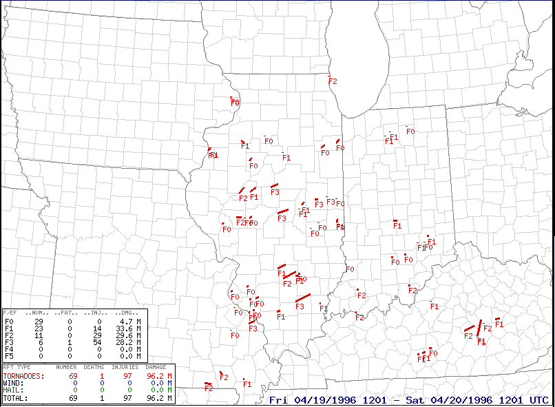
Tornado reports from 7 am April 19 to 7 am April 20

Tornadoes:

A total of 19 tornadoes occurred in the area covered by the Lincoln NWS

Track maps show the approximate path. 

Tornado #1 - 3 miles north of Mattoon
Coles County

Date 4/19/1996
Time (Local) 4:20 pm
F Rating F0
Est. Peak Winds N/A
Path Length 0.1 mile
Max Width 100 yards
Injuries/Deaths None

Summary:

Brief touchdown in an open field 2.5 miles north of Mattoon.

Track Map

Mattoon tornado track 


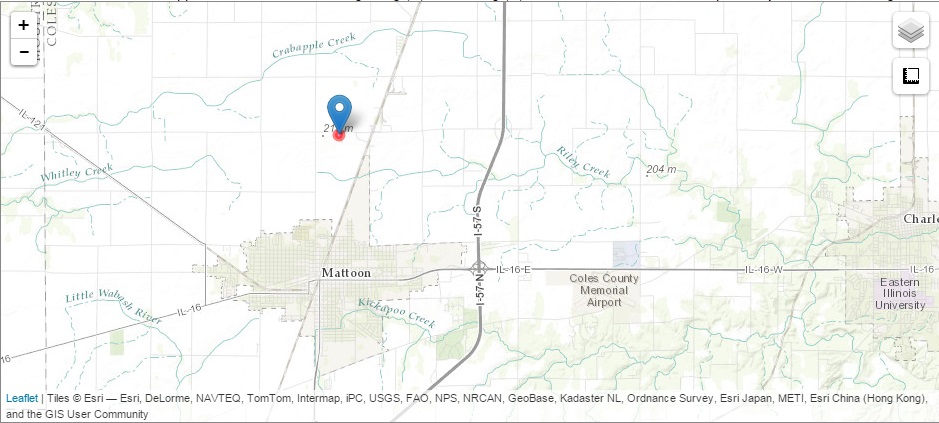
Tornado #2 - 3 miles north of Fairgrange
Coles County

Date 4/19/1996
Time (Local) 4:35 pm
F Rating F0
Est. Peak Winds N/A
Path Length 0.1 mile
Max Width 100 yards
Injuries/Deaths None

Summary:

Brief touchdown in an open field 3 miles north of Fairgrange.

Track Map

Fairgrange tornado track 


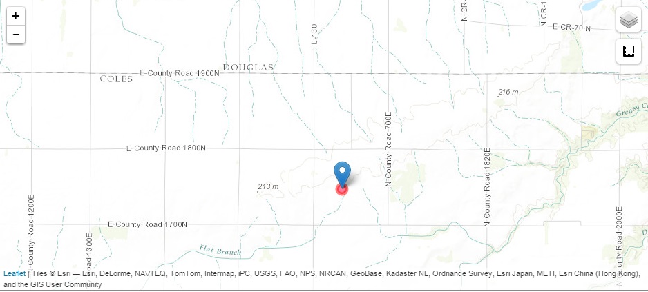
Tornado #3 - 3 miles northwest of Paris to 3 miles north of Paris
Edgar County

Date 4/19/1996
Time (Local) 5:10 pm - 5:16 pm
F Rating F1
Est. Peak Winds N/A
Path Length 2 miles
Max Width 440 yards
Injuries/Deaths None

Summary:

Touched down 3 miles northwest of Paris, destroying a barn. It continued east-northeast and damaged 6 farms in the area, including the destruction of several machine sheds, a couple barns, and grain bins. One residence had moderate roof damage and another had broken windows caused by baseball-size hail. The tornado lifted after crossing Highway 1 three miles north of Paris.

Track Map

Track of 1st Paris tornado 


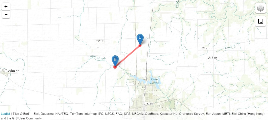
Tornado #4 - 2 miles north-northwest of Paris to 2 miles north of Paris
Edgar County

Date 4/19/1996
Time (Local) 5:12 pm - 5:16 pm
F Rating F0
Est. Peak Winds N/A
Path Length 1 mile
Max Width 220 yards
Injuries/Deaths None

Summary:

Touched down 1.5 miles north-northwest of Paris, near Cherry Point Road and County Road 200W, destroying a machine shed. It lifted briefly and touched down again at the intersection of Steidle Rd and Tucker Beach Rd, damaging a 3-car garage. It continued east-northeast and damaged another machine shed, numerous trees, and a baseball field. At Twin Lakes Park, several benches, trees and a small shed were damaged. It traveled across the lake and flipped a boat lift, before dissipating.  

Track Map

Track map of 2nd Paris tornado 


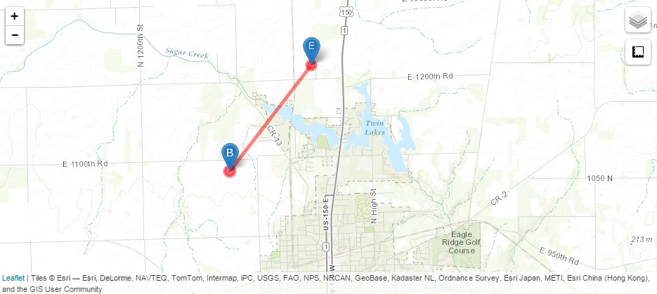
Tornado #5 - 5 miles west-southwest of Winchester to 3 miles west-southwest of Winchester
Scott County

Date 4/19/1996
Time (Local) 5:44 pm - 5:46 pm
F Rating F0
Est. Peak Winds N/A
Path Length 2 miles
Max Width 100 yards
Injuries/Deaths None

Summary:

Touched down 5 miles west-southwest of Winchester and traveled east-northeast. Just before it lifted (3 miles west-southwest of Winchester), it split off part of a tree which landed on a car, causing some damage.

Track Map

Winchester tornado track 


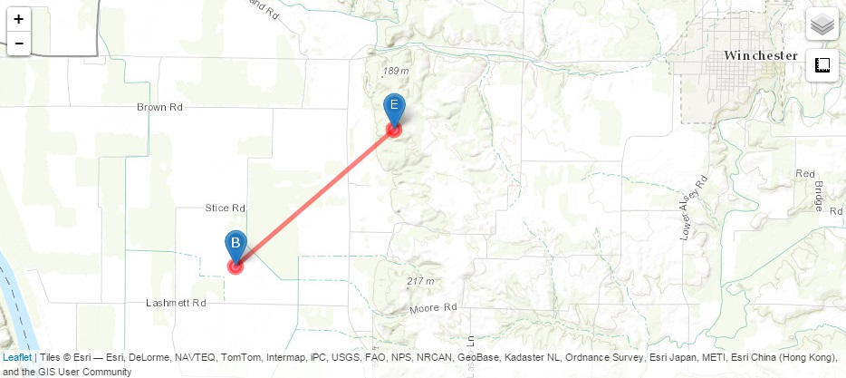
Tornado #6 - Bath to 1 mile east of Havana
Mason County

Date 4/19/1996
Time (Local) 6:07 pm to 6:17 pm
F Rating F2
Est. Peak Winds N/A
Path Length 9 miles
Max Width 250 yards
Injuries/Deaths 1 injury, 0 fatalities

Summary:

Caused major damage to one home in Bath and minor damage to 11 others. Two trailers destroyed, with 1 injury. The tornado continued northeast, destroying and uprooting numerous trees in the Bath Cemetery, blowing down numerous power lines, destroying numerous farm buildings, and blowing a semi-truck into a nearby field. 

Track Map

Bath to Havana tornado track 


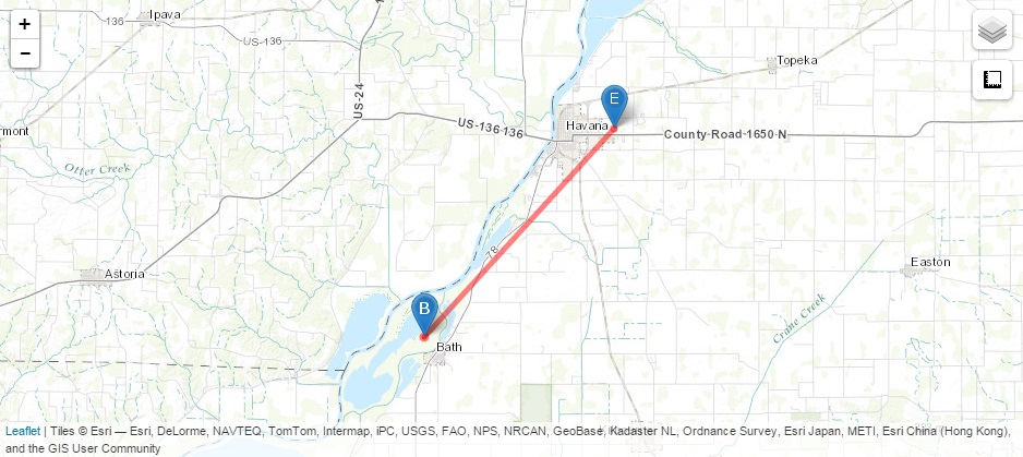
Tornado #7 - 1 mile southwest of Brimfield to 3 miles northeast of Brimfield
Peoria County

Date 4/19/1996
Time (Local) 6:10 pm - 6:16 pm
F Rating F0
Est. Peak Winds N/A
Path Length 4 miles
Max Width 100 yards
Injuries/Deaths None

Summary:

Touched down 1 mile southwest of Brimfield, and caused minor damage on the south side of town.

Track Map

Brimfield tornado track 


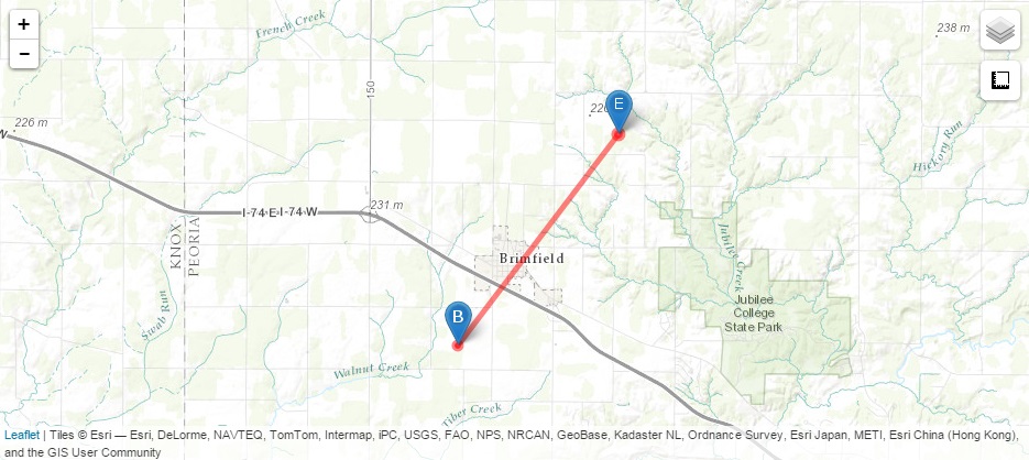
Tornado #8 - 2 miles west-southwest of Easton to 7 miles northeast of Easton
Mason County

Date 4/19/1996
Time (Local) 6:17 pm to 6:30 pm
F Rating F1
Est. Peak Winds N/A
Path Length 9 miles
Max Width 250 yards
Injuries/Deaths None

Summary:

Touched down 2 miles west-southwest of Easton and moved northeast. One home was destroyed on the northwest side of Easton. It lifted 3.5 miles northeast of Easton, then touched down again a mile later and remained on the ground for 3 more miles. Two homes were destroyed, 5 sustained major damage, and the roof was lifted up on the high school. 

Track Map

Easton tornado track 


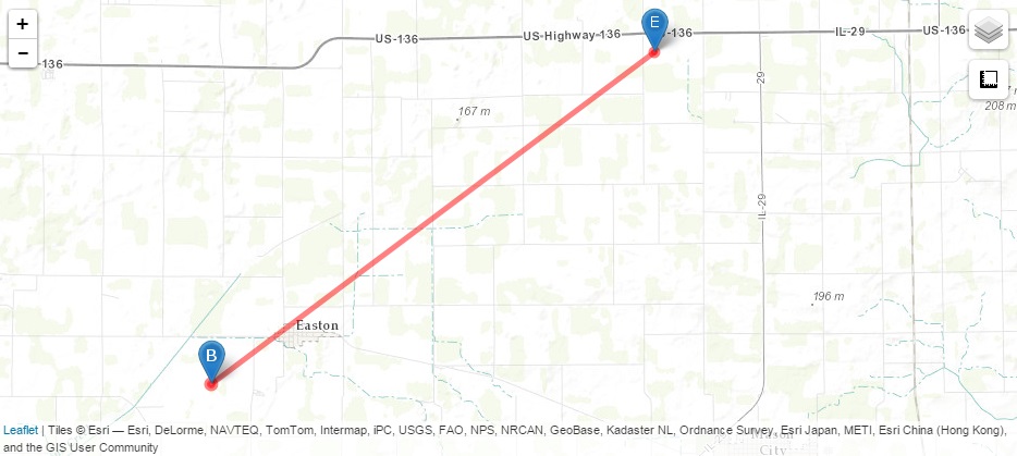
Tornado #9 - 2 miles east of Jacksonville to 1 mile north of Orleans
Morgan County

Date 4/19/1996
Time (Local) 6:18 pm to 6:28 pm
F Rating F2
Est. Peak Winds N/A
Path Length 6 miles
Max Width 880 yards
Injuries/Deaths 1 injured, 0 fatalities

Summary:

Touched down at the Mobil Chemical Plant 2 miles east of Jacksonville, and crossed part of the Jacksonville Correctional Facility. It lifted for 2 miles before touching down again and traveling 2 more miles before lifting 1 mile north of Orleans. Two railroad cars were overturned at the plant, and two guard towers, a greenhouse and a fence were damaged at the prison. One home east of the prison was destroyed, and 3 others had major damage. There was 1 minor injury at the prison.

Track Map

Track Map of Jacksonville F2 tornado 


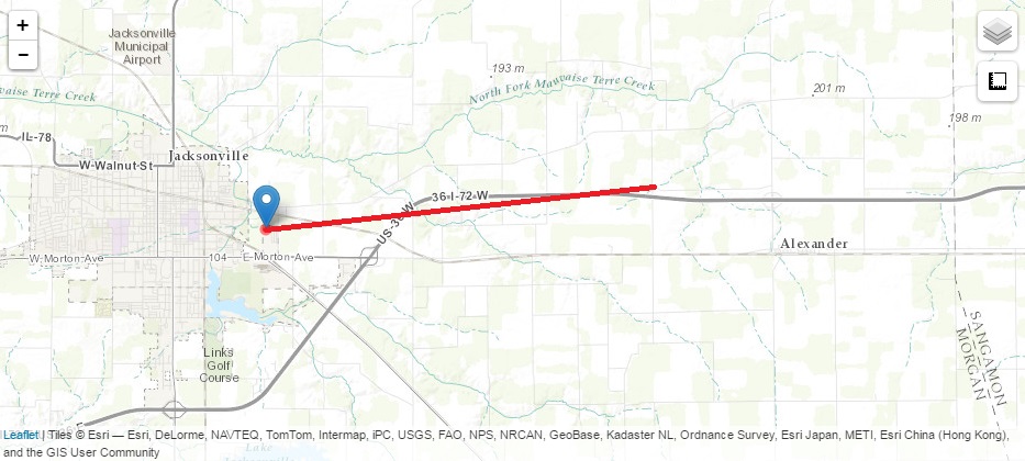
Tornado #10 - 2 miles east of Alexander
Morgan County

Date 4/19/1996
Time (Local) 6:31 pm
F Rating F0
Est. Peak Winds N/A
Path Length 0.1 mile
Max Width 100 yards
Injuries/Deaths None

Summary:

Brief touchdown 2 miles east of Alexander.

Track Map

Alexander tornado track 


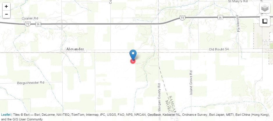
Tornado #11 - 2 miles east of New Berlin to 5 miles east-northeast of New Berlin
Sangamon County

Date 4/19/1996
Time (Local) 6:32 pm to 6:41 pm
F Rating F0
Est. Peak Winds N/A
Path Length 4 miles
Max Width 330 yards
Injuries/Deaths None

Summary:

Briefly touched down 2 miles east of New Berlin, then lifted and touched down again 5 miles east-northeast of New Berlin. Major damage to a home, barn, and machine shed. Two semis were blown over on I-72.

Track Map

New Berlin track map 


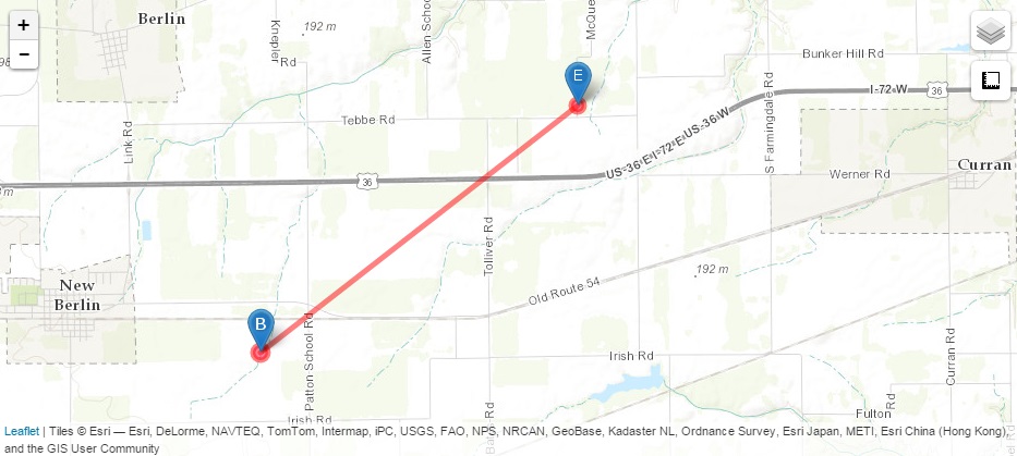
Tornado #12 - 3 miles north-northeast of Union to 4 miles west of Funks Grove
Logan, Tazewell, and McLean Counties

Date 4/19/1996
Time (Local) 6:58 pm to 7:19 pm
F Rating F3
Est. Peak Winds N/A
Path Length 9.4 miles
Max Width 880 yards
Injuries/Deaths None

Summary:

Touched down just south of the Logan/Tazewell County line along county road 1350E, causing minor damage to 3 homes. It crossed into Tazewell Couty and destroyed one home on the south side of Armington, and caused major damage to two others. It then moved into southwest McLean County and destroyed a church and one home. 

Track Map

Armington track map 


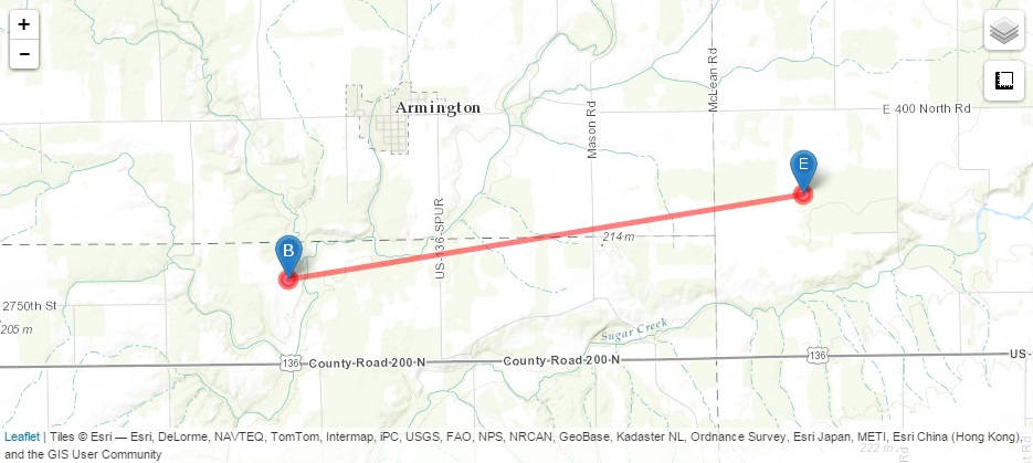
Tornado #13 - 2 miles south-southwest of Niantic to 3 miles northeast of Decatur
Macon County

Date 4/19/1996
Time (Local) 7:22 pm to 7:45 pm
F Rating F3
Est. Peak Winds N/A
Path Length 14.5 miles
Max Width 440 yards
Injuries/Deaths 29 injured, 0 fatalities

Summary:

Touched down 2 miles south-southwest of Niantic and traveled east-northeast. Moved into Old Harristown at 7:27 pm, destroying 5 homes and damaging the remainder of the homes and the old grade school gymnasium. It moved into the west side of Decatur near the intersection of Wyckles and Center Roads after crossing I-72, destroying a church. It demolished a house near Ravina Park Road, and caused damage in a 1.5 to 2 block wide area. It crossed Oakland Ave. and destroyed the Sims Lumber Company. After lifting briefly, it touched down again at Bloomington Rd. and Pythan Ave., then lifted again just east of Morgan St. It touched down once more near 27th and Pershing, damaging several roofs at a manufacturing plant. Total damage in the area was $9 million.

Track Map

Niantic to Decatur Track Map 


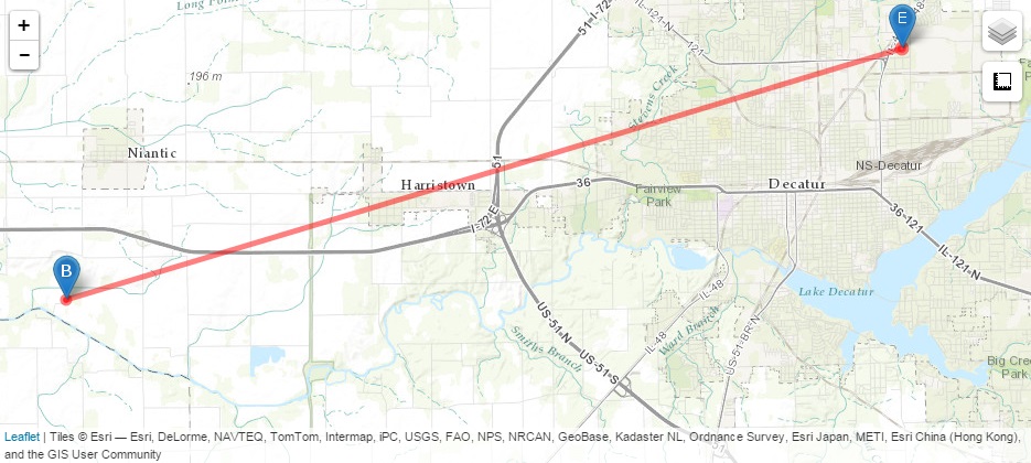
Tornado #14 - Milmine
Piatt County

Date 4/19/1996
Time (Local) 7:55 pm to 7:57 pm
F Rating F1
Est. Peak Winds N/A
Path Length 0.3 miles
Max Width 50 yards
Injuries/Deaths None

Summary:

Brief touchdown in Milmine, destroying a grain bin, throwing an auger across the railroad tracks, and causing minor damage to some homes.

Track Map

Milmine Track Map 


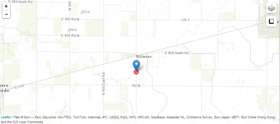
Tornado #15 - 3 miles south of Monticello to 2 miles southeast of Monticello
Piatt County

Date 4/19/1996
Time (Local) 8:00 pm to 8:10 pm
F Rating F1
Est. Peak Winds N/A
Path Length 2 miles
Max Width 300 yards
Injuries/Deaths 1 injury, 0 fatalities

Summary:

Touched down in the Breezy Meadows subdivision, destroying two homes and causing major damage to a church. It lifted and traveled northeast before touching down again near the Monticello Airport. It destroyed 3 single engine planes, 2 gliders and a hangar, before dissipating. Damage was estimated around $1 million.

Track Map

Monticello Track Map 


Tornado #16 - 11 miles east of Salem to 3 miles north-northwest of Xenia
Marion and Clay Counties

Date 4/19/1996
Time (Local) 8:05 pm - 8:14 pm
F Rating F1
Est. Peak Winds N/A
Path Length 5 miles
Max Width 50 yards
Injuries/Deaths None

Summary:

Touched down in extreme eastern Marion County, destroying a farmhouse before crossing the Clay County line. It downed some trees in Clay County before lifting 2.5 miles north-northwest of Xenia.

Track Map

Track Map of Xenia tornado 


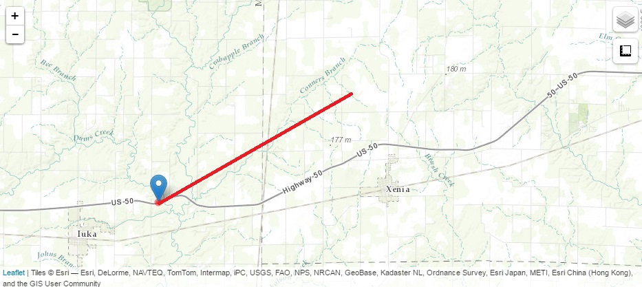
Tornado #17 - Savoy to Urbana
Champaign County

Date 4/19/1996
Time (Local) 8:34 pm to 8:47 pm
F Rating F3
Est. Peak Winds N/A
Path Length 4 miles
Max Width 220 yards
Injuries/Deaths 12 injuries, 0 fatalities

Summary:

Briefly touched down 1 mile north of Savoy, near US-45 and Curtis Rd., destroying 3 homes under construction. It lifted before touching down again 1 mile south of Urbana. It destroyed 30 homes, and caused moderate damage to 29 others. Five businesses were also damaged. Damage was estimated between $7 million and $11 million.

Track Map

Urbana Track Map 


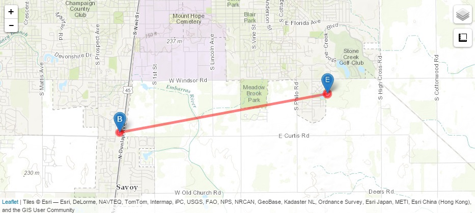
Tornado #18 - 1 mile southwest of Ogden to 1 mile north-northeast of Ogden
Champaign County

Date 4/19/1996
Time (Local) 8:55 pm to 8:58 pm
F Rating F3
Est. Peak Winds N/A
Path Length 2 miles
Max Width 1,500 yards
Injuries/Deaths 13 injuries, 1 fatality

Summary:

Passed northeast directly through the middle of Ogden, destroying 68 homes, 12 businesses, 3 churches, the library, and the grade school. East of town, it killed a woman in a semi as the tornado crossed I-74. It appeared there were multiple circulations within the parent tornado.

Track Map

Ogden Track Map 


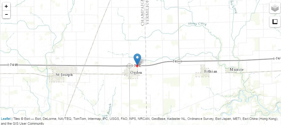
Tornado #19 - 1 mile northwest of Catlin
Vermilion County

Date 4/19/1996
Time (Local) 9:08 pm
F Rating F0
Est. Peak Winds N/A
Path Length 0.1 mile
Max Width 100 yards
Injuries/Deaths None

Summary:

Brief touchdown in an open field.

Track Map

Catlin Track Map 


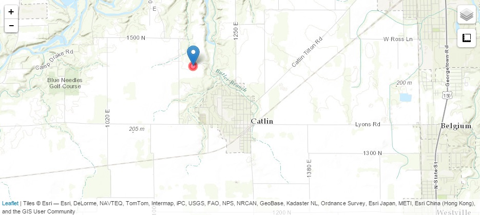
The original Fujita Scale was in use during the time of this event. It classified tornadoes into the following categories:

F0
Light

40-72 mph
F1
Moderate
73-112 mph
F2
Significant
113-157 mph
F3
Severe
158-206 mph
F4
Devastating
207-260 mph
F5
Incredible
261-318 mph
ef-scale

Radar:

The Doppler radar at Lincoln had only been in operation for about a year at the time of this event, and was officially commissioned in January of that year. 

Radar image from 6:20 pm
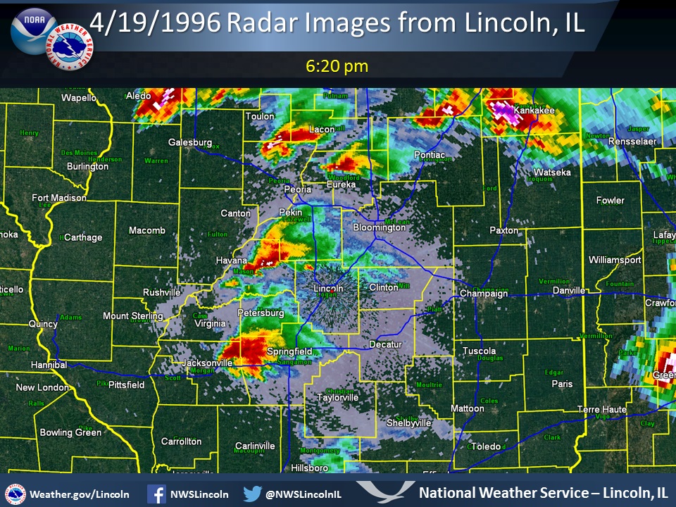
Radar image from 6:20 pm, showing 4 separate supercells over central Illinois

Click here for animated radar loop (3.0 MB).


Radar Image from 5:45 pm Radar Image from 5:57 pm

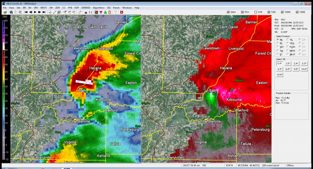
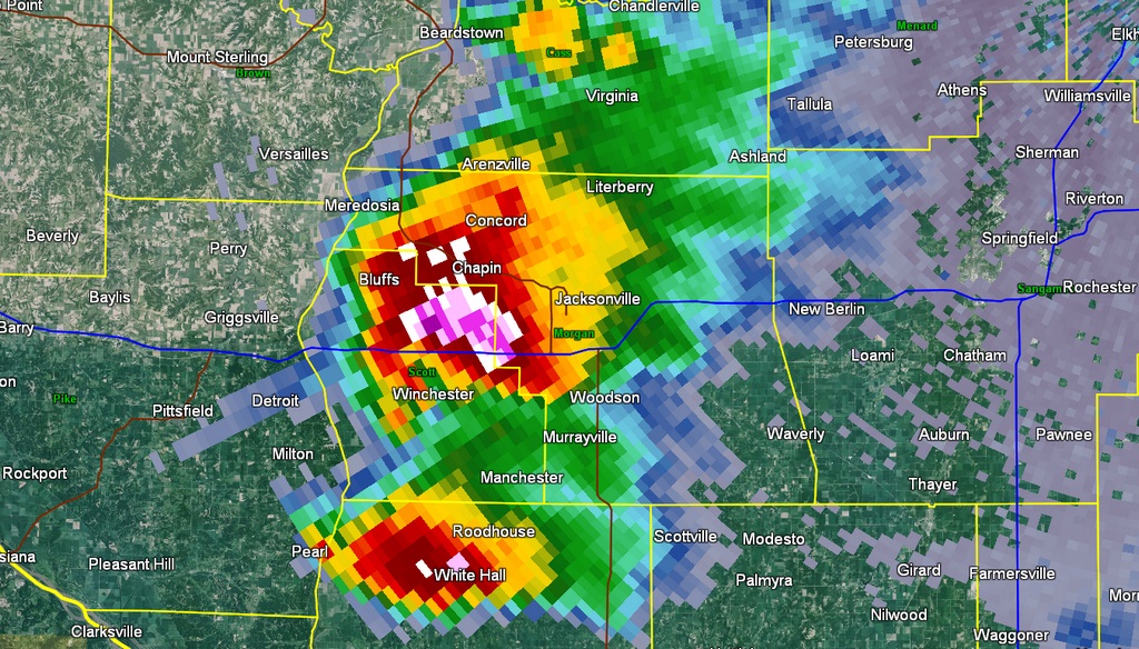
Left:  Radar image from 5:45 pm, with the storm north of Winchester. A hail spike is shown by the light reflectivities extending southwest through Detroit to just south of Pittsfield, indicating large hail.

Right:  Dual-panel image from 5:57 pm of reflectivity (left) and storm relative motion (right) products with the tornado near Bath.  A strong circulation is shown on the right panel, indicated by the pink and light blue/green shades coming together.

Radar Image from 6:09 pm Radar Image from 6:09 pm

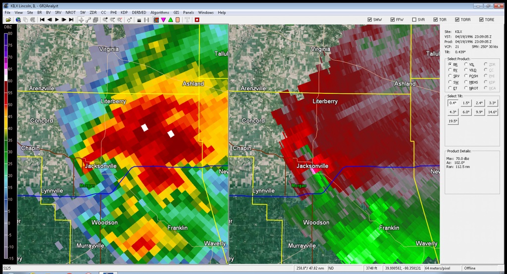
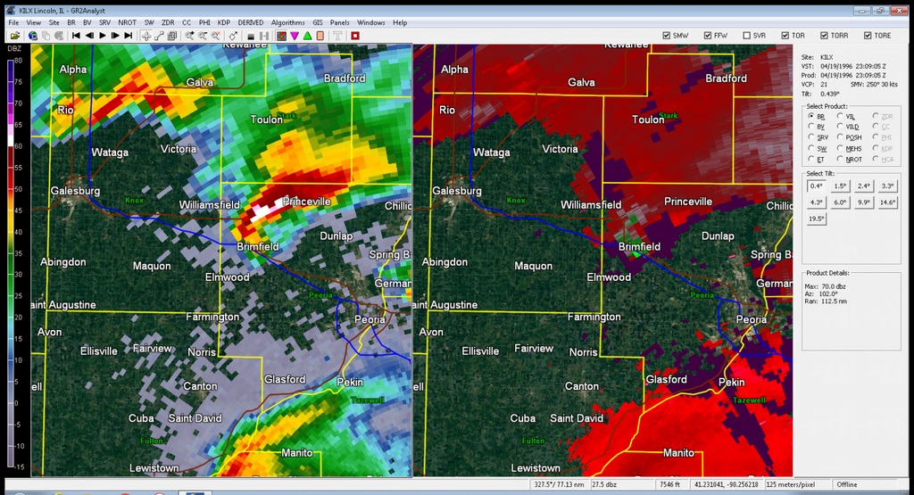
Left:  Dual-panel image from 6:09 pm of reflectivity (left) and storm relative motion (right) products of the supercell near Brimfield, shortly before it produced a tornado.

Right:  Also at 6:09 pm, the supercell near Jacksonville was showing signs of rotation (right panel, green shades against red/pink areas).  A tornado would touch down about 9 minutes later.

Radar Image from 6:20 pm Radar Image from 7:13 pm

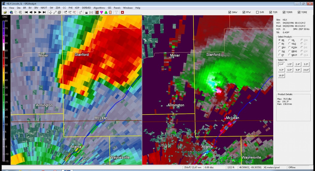
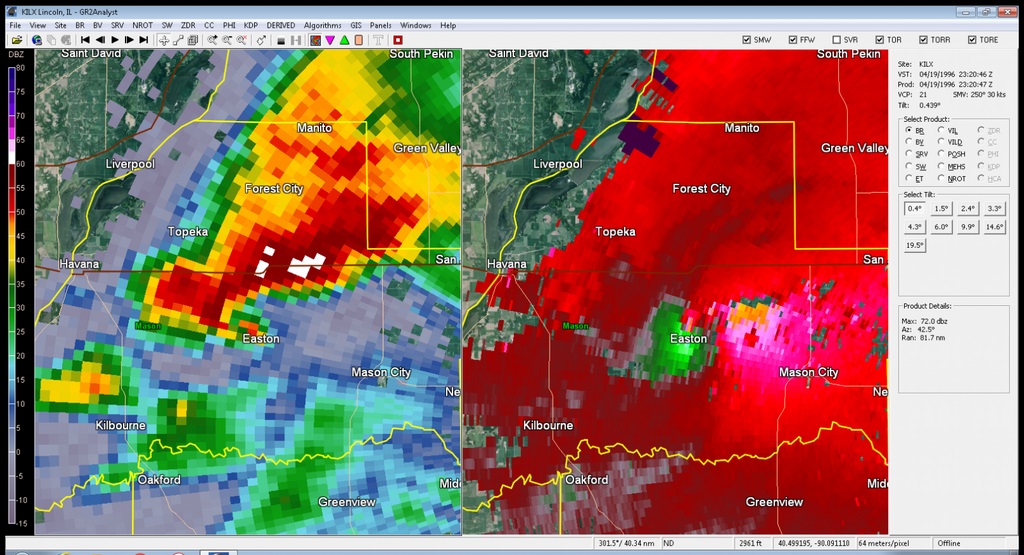
Left:  Dual-panel image from 6:20 pm of reflectivity (left) and storm relative motion (right) products of the Easton tornado. The hook echo over Easton (left panel) and strong circulation (right panel) are clearly visible. 

Right:  From 7:13 pm, the tornado in southwest McLean County is shown by the strong circulation in the right panel (pink shades against green/blue shades).

Radar Image from 7:25 pm Radar Image from 8:58 pm

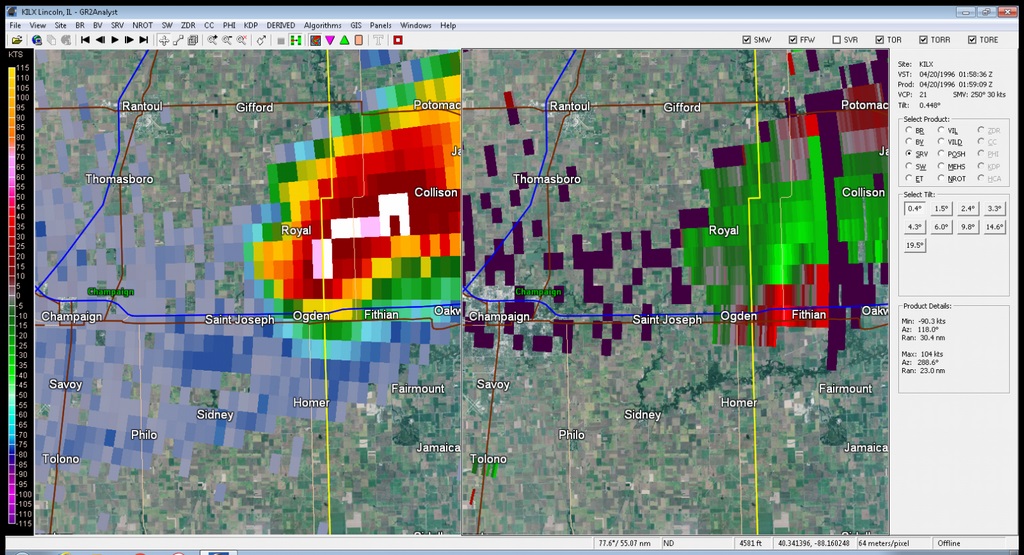
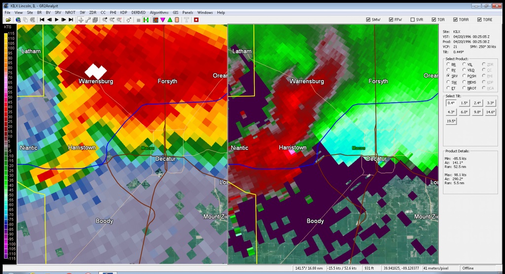
Left:  At 7:25 pm, a tornado was moving through the Harristown area, having touched down a few minutes prior. 

Right:  Radar image from 8:58 pm, shortly after a tornado exited Ogden. Due to the distance from the radar, the lowest level circulation is not visible, but rotation is still quite evident at the height of the radar beam (6200 feet), seen by the red and green shades together just northwest of Fithian. 


Additional Information

Other Reports

Large hail and strong winds accompanied these supercells.  Some of the other reports received as a result of these storms:

Time Location Report
4:47 pm Newman (Douglas Co.) 2 inch diameter hail
4:58 pm Brocton (Edgar Co.) Several windows blown out of a home
5:04 pm Toluca (Marshall Co.) Marble to golf ball size hail fell for over 30 minutes
5:10 pm Paris (Edgar Co.) Golf ball size hail
5:20 pm 5 miles north of Paris (Edgar Co.) Several windows blown out of a home
5:25 pm Astoria (Fulton Co.) Golf ball size hail
5:30 pm 4 miles south of Knoxville (Knox Co.) Golf ball size hail
5:47 pm 1 mile north of Winchester (Scott Co.) Power pole snapped in half
5:48 pm Winchester (Scott Co.) Golf ball size hail
6:38 pm Delavan (Tazewell Co.) Golf ball size hail, and numerous power lines blown down
7:17 pm Illiopolis (Sangamon Co.) Semi-trailer blown over on I-72 due to strong winds
8:26 pm Flora (Clay Co.) Several trees and power lines blown down
8:30 pm Champaign (Champaign Co.) Golf ball size hail
8:34 pm Savoy, Willard Airport (Champaign Co.) 75 mph wind gust
8:58 pm 3 miles northwest of Olney (Richland Co.) Strong winds blew apart a trailer
8:58 pm Teutopolis (Effingham Co.) Strong winds blew down a tree onto a car, causing 1 injury


How have things changed since 1996?

Item How it was done in 1996 How it is done now
Issuing severe weather warnings Radar data was analyzed on two large monitors, using a tablet and mouse. When a warning was needed, the forecaster went to a separate workstation to create the warning. The computer program filled in some of the warning, but large parts of it had to be manually inserted. Radar data is analyzed on the same workstation that is used to review other weather data. When a warning is needed, the warning creation software (which is also on the same workstation) is used to "draw" the area in danger. A few mouse clicks are used to select the hazards (e.g. 70 mph winds, golf ball size hail, etc.). With this, a fully formatted warning is assembled in a minute or less.
NOAA Weather Radio NWS staff manually recorded each message, using 8-track tapes. As there were 3 separate stations, updates could be delayed as separate messages had to be created for each station. Up to 8 messages could be included in each broadcast. A computer automatically processes forecasts, weather bulletins, and observations, and uses a synthesized voice to create broadcasts for all 9 stations operated by the office, with room to expand. There is no limit to the number of messages included in each broadcast.

Summaries from other NWS Offices


nws logo Media use of NWS Web News Stories is encouraged!
Please acknowledge the NWS as the source of any news information accessed from this site.
nws logo