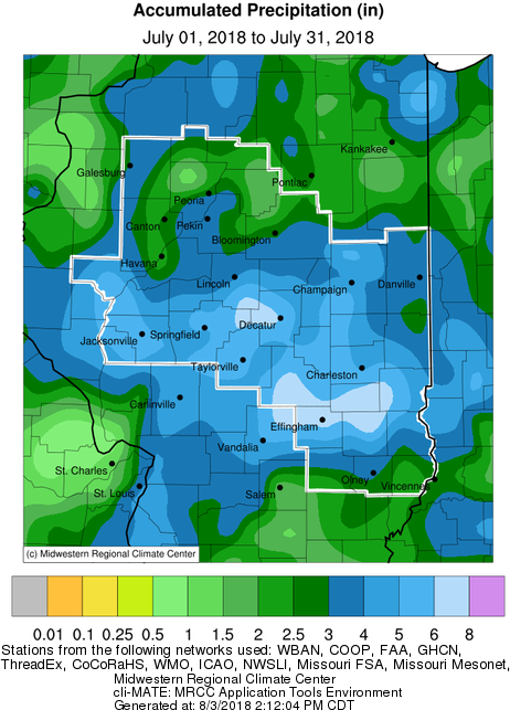
July Precipitation Highlights:
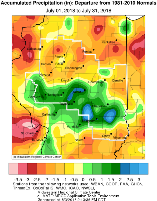
- Rainfall was an inch or two below normal for much of central and southeast Illinois.
- A corridor from Jacksonville to Decatur, southeast to Effingham and Newton, saw above normal rainfall. This was the result of heavy rains which fell at the end of the month.
- Severe weather was isolated during the month. However, heavy rain was observed at the beginning and end of the month...
- July 1st - The air mass ahead of an approaching cold front became highly unstable during the afternoon of July 1st. Storms began to form west of the Illinois River then progressed eastward to the I-55 corridor by late afternoon. Outflow boundaries created by individual cells merged in a few spots, creating weak rotation and enhanced wind gusts. Severe weather reports included a large tree blown down in Waynesville in Dewitt County and two power poles leaning near Boody in Macon County. In addition, where the storms were able to organize into more concentrated clusters, pockets of torrential rain occurred. The most notable area of heavy rain occurred across the southern half of Macon County into northern Christian County where 2 to 3 inches of rain fell.
- July 29-30 - A deep upper trough brought a fall-like pattern to the region, and produced widespread cloud cover and showers which kept temperatures well below normal. A couple periods of localized heavy rainfall occurred. The first impacted locations from Winchester and Jacksonville southeast to around Effingham on the 29th, while another materialized across portions of Sangamon, Logan, and DeWitt counties and in a swath from Shelbyville to Paris during the early morning hours of July 30th. Some impressive rainfall totals were reported, with the highest in Neoga in Cumberland County with 5.70". Despite a large portion of central Illinois picking up 1 to 3 inches of rain, there were plenty of areas that were largely missed. For example, locations along and north of a Macomb to Bloomington line, and along and south of a Salem to Robinson line saw little or no rain.
 |
 |
| July Precipitation |
July Precipitation Departure from Normal |
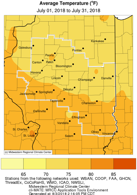
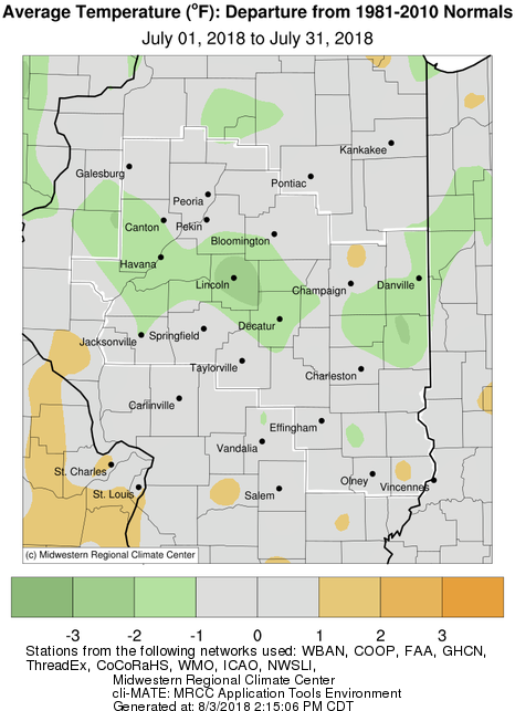
July Temperature Highlights:
- After above normal temperatures for most of the first half of the month, most of the second half of July saw below normal temperatures. This resulted in readings within a degree of normal for much of the area, though a small corridor across the central part of the state averaged 1-3 degrees below normal.
- As a result of widespread cloud cover and rainfall associated with an upper level low pressure system, several locations experienced daily record cool high temperatures in the upper 60s and lower 70s on Sunday, July 29th.
 |
 |
| July Mean Temperature |
July Temperature Departure from Normal |
July Climate Data:
|
Site
|
Precipitation
|
Departure from Normal |
Average Temperature
|
Departure from Normal |
|
Charleston
|
4.43" |
-0.04" |
76.3 |
+0.1 |
| Danville |
4.93"
|
+0.26" |
74.3 |
-0.8 |
| Decatur |
6.94"
|
+2.96" |
74.7 |
-1.8 |
| Effingham |
5.84" |
+1.41" |
77.0 |
+0.6 |
|
Flora
|
2.10" |
-2.01" |
77.3 |
+0.2 |
| Galesburg |
2.41"
|
-1.97" |
74.7 |
+0.1 |
|
Havana
|
1.90" |
-2.14" |
N/A |
N/A |
|
Jacksonville
|
5.35" |
+1.49" |
76.0 |
-1.1 |
| Lincoln |
3.86" |
-1.21" |
71.9 |
-3.1 |
|
Normal
|
1.61"
|
-2.55" |
73.4 |
-1.0 |
|
Olney
|
3.15" |
-1.18" |
76.5 |
+0.1 |
|
Paris
|
4.04" |
-0.39" |
73.1 |
-2.4 |
| Peoria |
4.46"
|
+0.61" |
75.4 |
-0.1 |
| Springfield |
6.34"
|
+2.40" |
76.1 |
+0.3 |
|
Tuscola
|
5.03" |
+0.27" |
74.4 |
-1.1 |
| Urbana |
4.14"
|
-0.56" |
74.3 |
-0.6 |
The following links are the monthly and seasonal climate summaries for area cities. Only the summaries for Peoria, Springfield, and Lincoln are considered "official", meaning they are the station of record for their respective locations. The other summaries are "supplemental", meaning another location in the area is the official climate station for the city.
Climate data for other cities is available at http://w2.weather.gov/climate/xmacis.php?wfo=ilx


 Follow us on YouTube