Overview
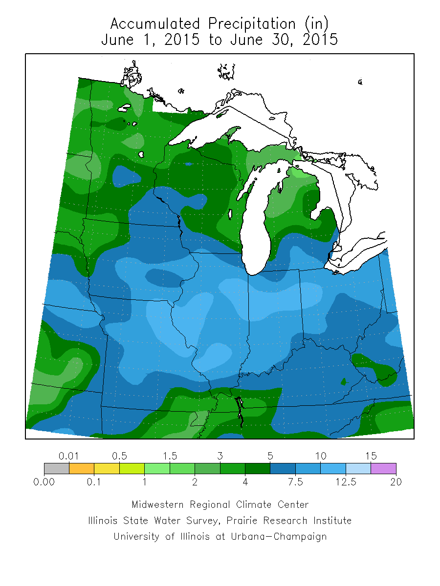
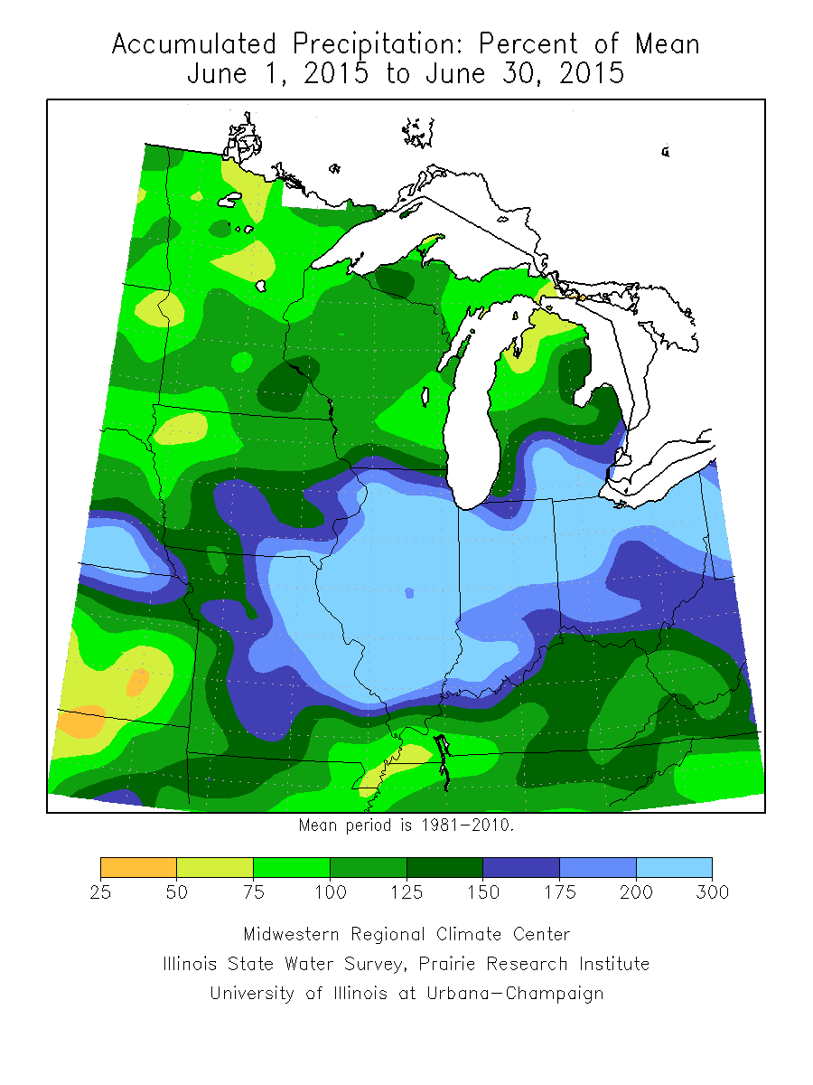
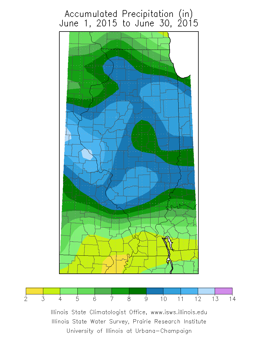
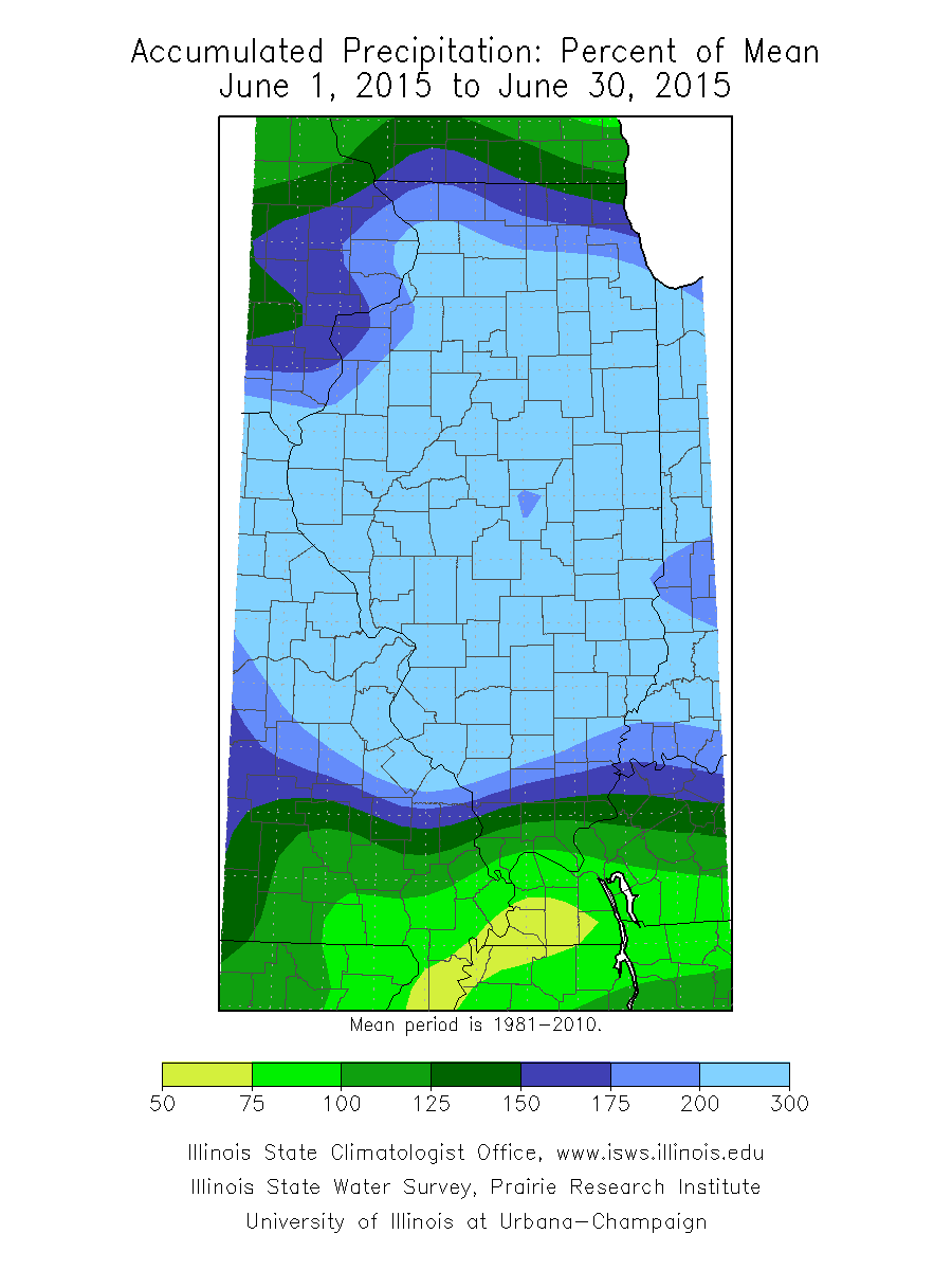
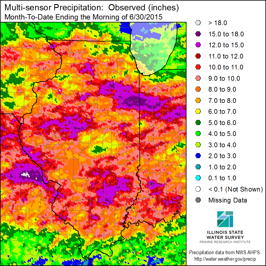
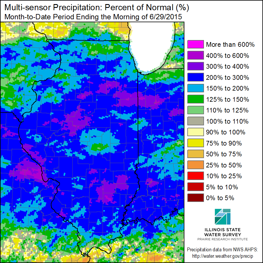
June 2015 was an extremely wet month for central and southeast Illinois, and was the wettest June on record for Illinois (statewide average) with 9.53". This puts June 2015 as the second wettest month all-time, behind September 1926 (9.62"). This wet period started with a nearly stationary frontal boundary, which wavered across the region June 7th-18th, and a very moist atmosphere which has brought high humidity into the Midwest. An active jet stream brought numerous upper level disturbance and low pressure systems through the area, enhancing rain amounts. The remnants of tropical storm Bill moved into the area on June 18-19, bringing more heavy rain of 2 to 5 inches to the southern half of Illinois. Then, for the 20th through the end of the month, numerous frontal boundaries and upper level disturbances tracked across the area, bringing more heavy rain. This put most reporting sites into their top 10 wettest June on record. Cities that had their wettest June include: Canton, Chenoa, Danville, Flora, Havana, Lacon, Mackinaw, Olney, Petersburg, Rushville, and Sullivan. June rainfall maps below show how the highest amounts were observed over a large area from Missouri, east across Illinois and into Indiana. This amount of rain caused many area rivers to go above flood stage with major flooding along the Illinois river from Havana to Beardstown and areas downstream. Keep updated on river stages and forecasts through our AHPS page.
Rainfall Maps (click to enlarge)
 |
 |
|
Midwest June Rainfall
|
Midwest % of Normal June Rainfall |
 |
 |
|
Illinois June Rainfall
|
Illinois % of Normal June Rainfall
|
 |
 |
|
Multi-sensor June Rainfall
|
Multi-sensor % of Normal June Rainfall |
Preliminary Rain Totals (from NWS Cooperative observers and Airport ASOS - updated July 1)
| Location | June 2015 Rainfall | June Normal Rainfall | June Rainfall Rank (since records began) |
| Altona | 9.16" | 4.38" | 2nd wettest June since 2005 |
| Arthur 1W | 9.46" | N/A | |
| Athens 4SW | 6.91" | 4.22" | |
| Beecher City | 10.73" | 4.28" | 2nd wettest June since 1974 |
| Bloomington 5W | 11.13" | 3.92" | Wettest June since 2000 |
| Bloomington Waterworks | 8.74" | 4.09" | Wettest June since 1948 |
| Bloomington AWSS | 8.77" | N/A | |
| Buffalo | 7.61" | N/A | |
| Canton | 13.71" | 4.67" | Wettest June since 1940 |
| Casey | 8.25" | 4.42" | 7th wettest June since 1893 |
| Champaign ASOS | 8.35" | 4.17 | |
| Charleston | 8.01" | 4.35" | 9th wettest June since 1896 |
| Chenoa #2 | 11.83" | 3.71" | Wettest June since 1944 |
| Cisco | 6.64" | N/A | |
| Clay City 6SSE | 8.98" | 4.01" | 2nd wettest June since 1947 |
| Clinton 1SSW | 7.16" | 4.27" | 15th wettest since 1910 |
| Congerville 2NW | 9.83" | 3.93" | Wettest June since 1991 |
| Dahinda 1NE | 8.93" | N/A | |
| Danville | 13.05" | 4.55" | Wettest June since 1895 |
| Danville STP | 14.51" | 4.34" | Wettest June since 1948 |
| Decatur WTP | 5.75" | 4.50" | 27th wettest June since 1894 |
| Decatur ASOS | 5.19" | 4.35" | |
| Effingham 3SW | 11.07" | 4.10" | 3rd wettest June since 1893 |
| Effingham SE | 13.51" | 4.23" | Wettest June since 2000 |
| Eureka | 10.18" | N/A | Wettest June since 2000 |
| Fisher | 10.72" | N/A | 2nd wettest June since 1997 |
| Farmer City | 7.41" | 4.29" | 7th wettest June since 1963 |
| Flora | 14.63" | 4.18" | Wettest June & 2nd wettest month since 1893 |
| Galesburg | 6.88" | 4.30" | 15th wettest June since 1927 |
| Havana | 13.75" | 4.36" | Wettest June since 1917 |
| Hoopeston | 7.64" | 4.38" | 10th wettest June since 1902 |
| Hutsonville | 7.21" | 4.20" | 8th wettest June since 1946 |
| Jacksonville 2E | 9.87" | 7th wettest June since 1895 | |
| Jacksonville #2 | 10.49" | 4.48" | |
| Kincaid 3W | 8.46" | 4.47" | 3rd wettest June since 1973 |
| Knoxville | 6.24" | 4.51" | 7th wettest June since 2000 |
| Lacon 1N | 12.78" | 3.86" | Wettest June since 1950 |
| Lake Springfield | 7.27" | 4.35" | 4th wettest June since 2000 |
| Lawrenceville ASOS | 9.02" | 3.98" | |
| Lincoln | 9.67" | 4.32" | 3rd wettest June since 1906 |
| Lovington | 6.94" | 4.46" | 5th wettest June since 2000 |
| Mackinaw 1N | 11.89" | 3.74" | Wettest June since 1940 |
| Mattoon | 6.59" | 4.11" | 10th wettest June since 1948 |
| Mattoon ASOS | 9.30" | 4.24" | |
| Minonk | 7.52" | 3.77" | 8th wettest June since 1895 |
| Morton | 11.13" | 3.93" | Wettest June since 1997 |
| Mount Pulaski | 6.13" | 4.05" | 19th wettest June since 1942 |
| Mowequa 2S | 7.75" | 4.56" | 4th wettest June since 1963 |
| Neoga 4NW | 10.20" | 4.66" | Wettest June since 2006 |
| Newton | 12.14" | N/A | 2nd wettest June since 1911 |
| Normal 4NE | 8.39" | 3.91" | 4th wettest June since 1893 |
| Ogden | 12.12" | 4.68" | Wettest June since 2002 |
| Olney 2S | 11.12" | 4.19" | Wettest June since 1890 |
| Pana | 8.39" | 4.51" | 8th wettest June since 1890 |
| Paris | 8.48" | 4.35" | 10th wettest June since 1893 |
| Peoria 5NW | 10.16" | N/A | |
| Peoria ASOS | 11.60" | 3.53" | 2nd wettest June since 1883 |
| Petersburg 1N | 11.31" | 4.09" | Wettest June since 1940 |
| Philo | 9.29" | 4.67" | 2nd wettest June since 2003 |
| Rantoul | 9.92" | N/A | Wettest June since 1965 |
| Roanoke | 9.12" | 3.85" | Wettest June since 2001 |
| Rushville 4NE | 13.75" | 4.57" | Wettest June since 1890 |
| Shelbyville Dam | 7.17" | 3.85" | 5th wettest June since 1997 |
| Sherman 1ESE | 9.97" | 4.55" | 2nd wettest June since 2000 |
| Sidell 5NW | 8.67" | 3.78" | 5th wettest June since 1913 |
| Springfield #2 | 9.22" | 4.57" | 2nd wettest June since 2003 |
| Springfield ASOS | 9.14" | 4.46" | 5th wettest since 1879 |
| Sullivan 3S | 11.93" | 4.44" | Wettest June since 1899 |
| Taylorville 2SW | 8.14" | N/A | 5th wettest June since 1941 |
| Trimble 1E | 5.00" | N/A | |
| Tuscola | 8.95" | 4.44" | 4th wettest June since 1893 |
| Urbana | 9.16" | 4.34" | 3rd wettest June since 1888 |
| Virginia | 9.77" | 4.29" | 3rd wettest June since 1963 |
| Windsor | 9.29" | 4.09" | 5th wettest since 1904 |
| Illinois | 9.53" | 4.20" | Wettest June since 1895 |
Links below are the monthly climate summaries for area cities. Only the summaries for Peoria, Springfield and Lincoln are considered "official", meaning they are the station of record for their respective locations. The other summaries are "supplemental", meaning another location in the area is the official climate station for that city.
Climate data for other area cities is available at http://www.nws.noaa.gov/climate/xmacis.php?wfo=ilx


 Follow us on YouTube