Overview
|
Severe thunderstorms rapidly developed from the Illinois River Valley into east central Illinois early in the afternoon on Sunday June 10, 2018. The thunderstorms started to produce wind damage in southern Tazewell County between Noon and 1 pm CDT. After 1 pm CDT, a line of thunderstorms began to form which produced wind damage in a large part of central Illinois from Bloomington through Clinton to Champaign /Urbana. Several areas of rotation on the leading edge of the line of storms developed from Bloomington/Normal to Champaign/Urbana. One of these produced two brief tornado touchdowns on the southwest edge of Champaign that damaged house roofs, and knocked down trees and power poles. Several rounds of thunderstorms produced damage in Vermilion County, The line of storms continued to produce damage from west of Decatur toward Paris before exiting the region around 4 pm. Click here for a link to the NWS Public Information Statement regarding the tornado damage survey |
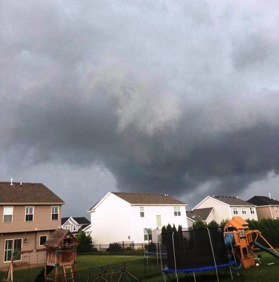 Photo by Melinda Emmerd Wall cloud/rotation approaching Champaign |
Tornadoes:
|
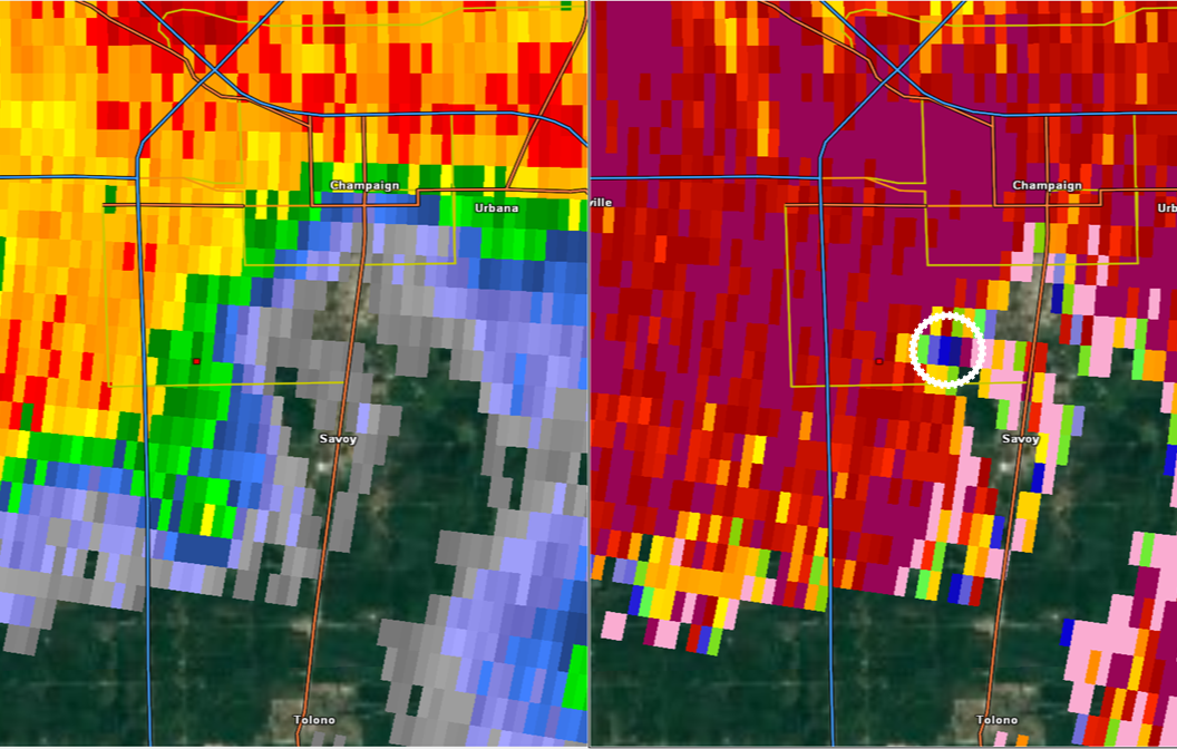
Tornado - Champaign (Copper Ridge Rd)
Track Map 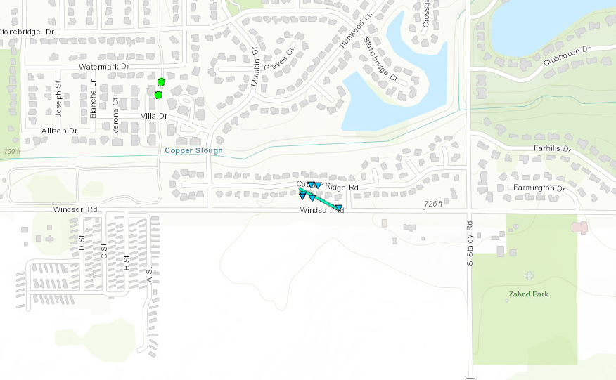 
Downloadable KMZ File |
||||||||||||||||
|
Tornado-Champaign (Rolling Acres Dr.)
Track Map 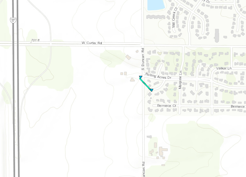
Downloadable KMZ File |
||||||||||||||||
The Enhanced Fujita (EF) Scale classifies tornadoes into the following categories:
| EF0 Weak 65-85 mph |
EF1 Moderate 86-110 mph |
EF2 Significant 111-135 mph |
EF3 Severe 136-165 mph |
EF4 Extreme 166-200 mph |
EF5 Catastrophic 200+ mph |
 |
|||||
Wind Damage:
Widespread wind damage was reported across a large part of central and east central Illinois between Noon and 4:00 pm on Sunday June 10th. Numerous trees, power poles, buildings and crops were damaged from wind gusts estimated to be 60 to 80 mph. See the "STORM REPORTS" tab of this web page for details.
 |
 |
 |
 |
|
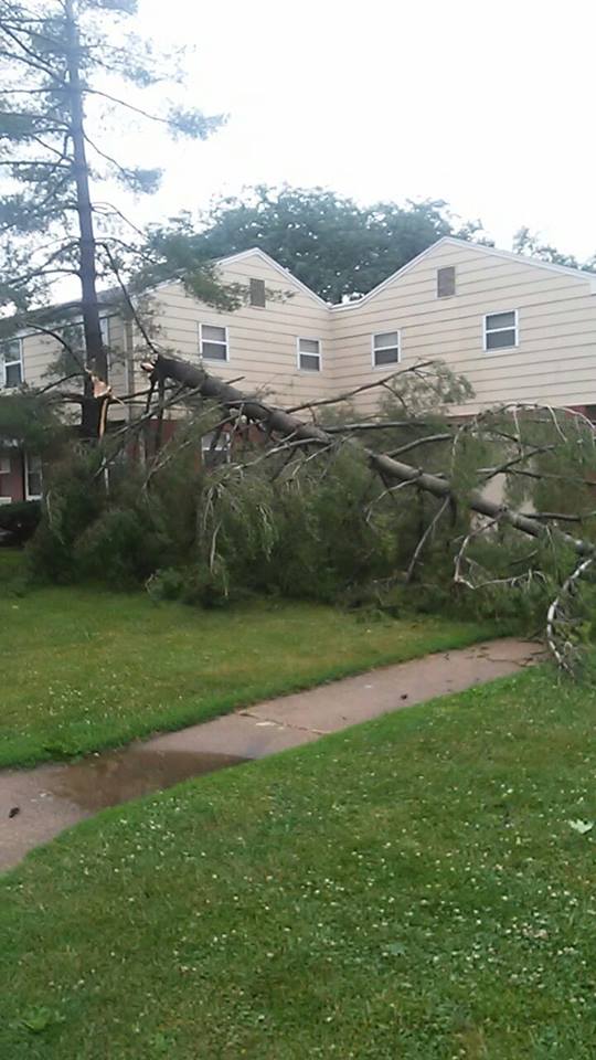
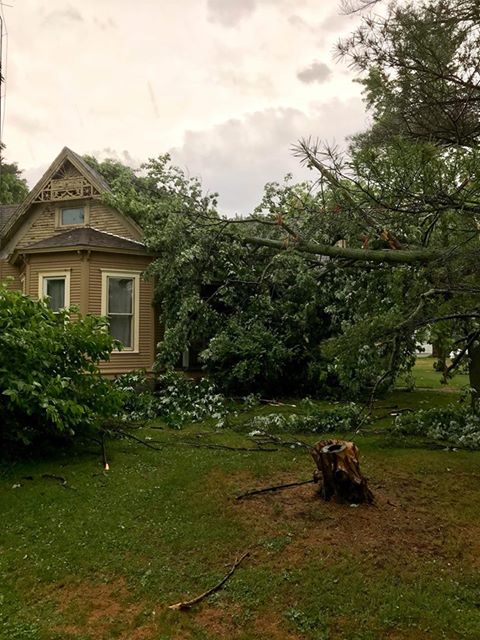
Photo by DeWitt Co EMA Wind Damage in Clinton |
Photo by Thomas Pruitt Wind Damage in Rantoul |
Photo by Vermilion Co EMA Tree on home near Georgetown |
Cumberland County Tree on home in Toledo, IL |
Tornado Damage Photos:
 |
 |
 |
 |
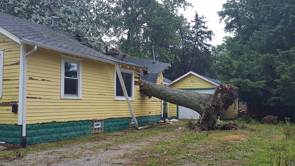
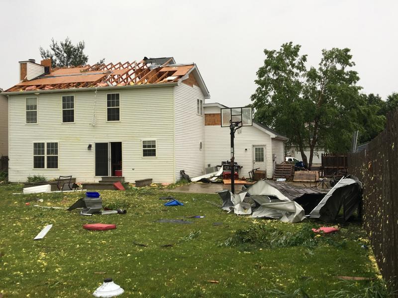
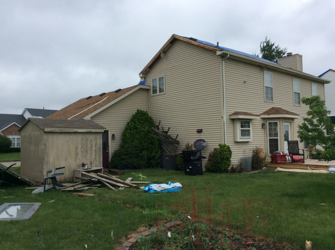
| Roof Damage to home on Copper Ridge Road Photo from City of Champaign |
Damage to a home on Copper Ridge Road Photo by NWS Lincoln |
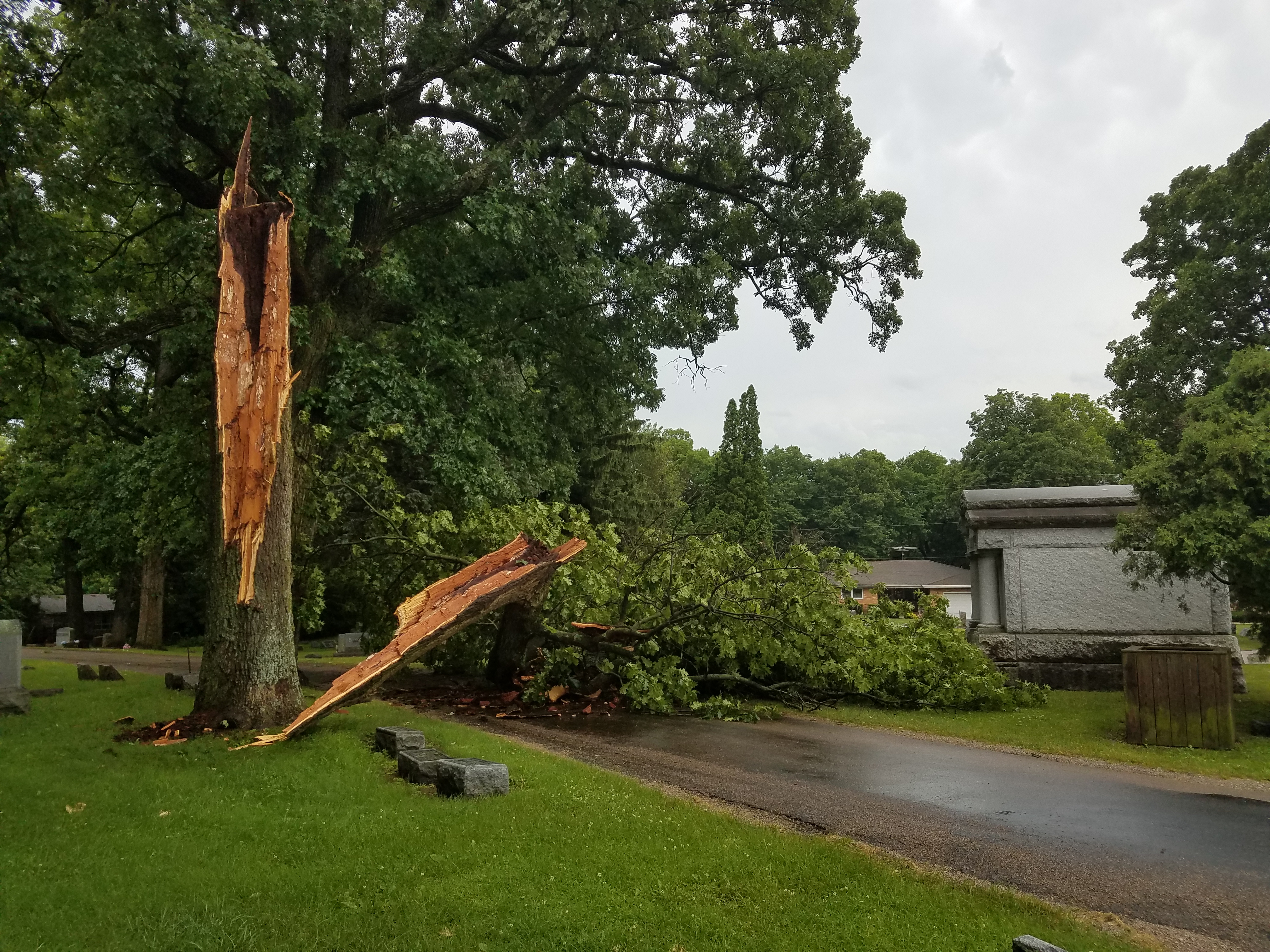
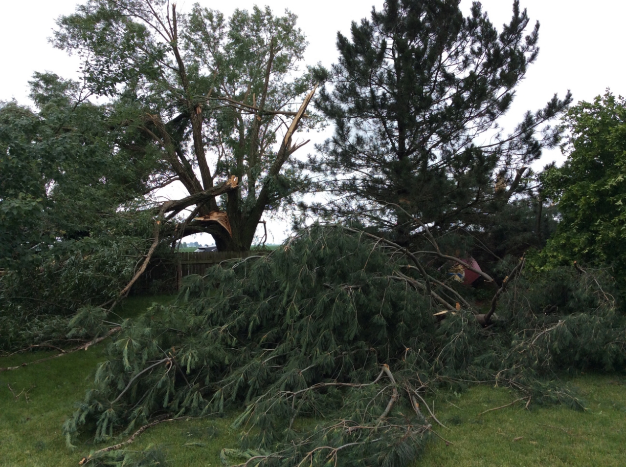
Tree Damage on Copper Ridge Road Photo by NWS Lincoln |
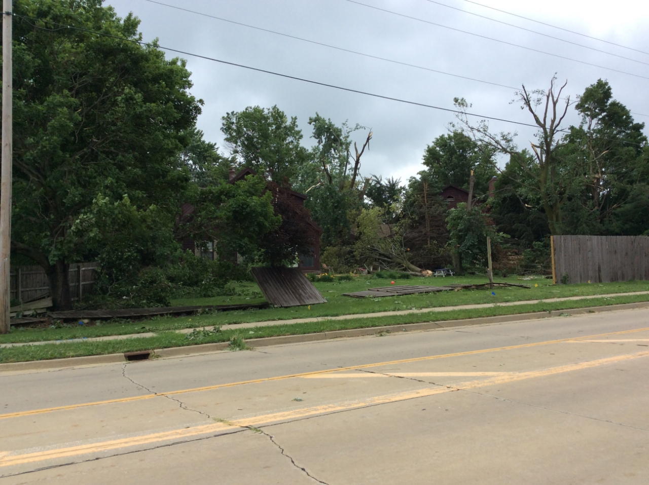
Damage to trees and fence on Rolling Acres Dr. Photo by NWS Lincoln |
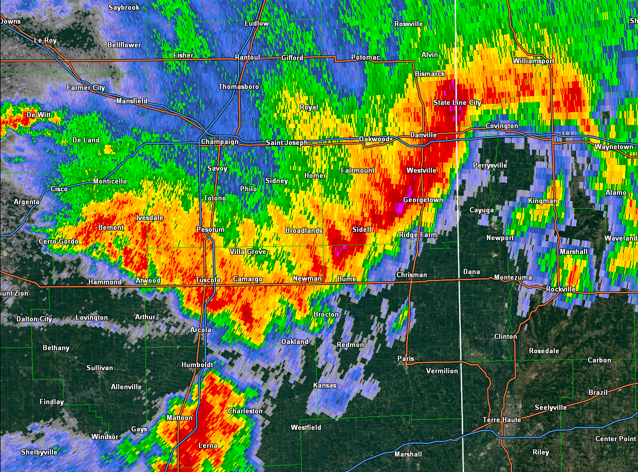
Radar:
 |
 |
 |
|
Lincoln Doppler Radar |
Lincoln Doppler Radar |
Lincoln Doppler Radar Reflectivity showing the line of severe thunderstorms approaching southeast Vermilion Co. and the town of Georgetown, IL |
Storm Reports
PRELIMINARY LOCAL STORM REPORT...SUMMARY
NATIONAL WEATHER SERVICE LINCOLN IL
414 PM CDT MON JUN 11 2018
..TIME... ...EVENT... ...CITY LOCATION... ...LAT.LON...
..DATE... ....MAG.... ..COUNTY LOCATION..ST.. ...SOURCE....
..REMARKS..
1211 PM TSTM WND GST DELAVAN 40.37N 89.54W
06/10/2018 M56.00 MPH TAZEWELL IL BROADCAST MEDIA
DELAYED REPORT.
0117 PM TSTM WND DMG 1 N DELAVAN 40.39N 89.54W
06/10/2018 TAZEWELL IL PUBLIC
REPORT OF PINE TREES SNAPPED.
0120 PM TSTM WND GST DELAVAN 40.37N 89.54W
06/10/2018 E60.00 MPH TAZEWELL IL PUBLIC
0120 PM TSTM WND DMG 2 SW BLOOMINGTON 40.46N 89.00W
06/10/2018 MCLEAN IL NWS EMPLOYEE
LARGE TREE LIMBS BLOWN DOWN.
0122 PM TSTM WND DMG 1 ESE BLOOMINGTON 40.47N 88.96W
06/10/2018 MCLEAN IL NWS EMPLOYEE
NUMEROUS LARGE TREE LIMBS DOWN. LARGE LIMB DAMAGED A CAR.
0147 PM TSTM WND DMG DANVILLE 40.14N 87.62W
06/10/2018 VERMILION IL EMERGENCY MNGR
REPORT OF A TREE DOWN ON POWER LINES ON NORTH KIMBALL
STREET. TREE ALSO FELL ONTO A GARAGE CAUSING SIGNIFICANT
DAMAGE.
0151 PM TSTM WND DMG CLINTON 40.15N 88.96W
06/10/2018 DE WITT IL EMERGENCY MNGR
DAMAGE TO A SHED ROOF NEAR ADAMS AND PORTLAND. ALSO CABLE
WIRES DOWN ON ISABELLA. TIME ESTIMATED BY RADAR.
0200 PM TSTM WND DMG LE ROY 40.34N 88.76W
06/10/2018 MCLEAN IL EMERGENCY MNGR
REPORT OF A TREE BLOCKING THE ROADWAY IN EMPIRE TOWNSHIP.
0205 PM TSTM WND DMG MANSFIELD 40.21N 88.51W
06/10/2018 PIATT IL PUBLIC
NUMEROUS TREES REPORTED DOWN.
0207 PM TSTM WND DMG 4 NW FARMER CITY 40.29N 88.69W
06/10/2018 MCLEAN IL EMERGENCY MNGR
REPORT OF TREE LIMB DOWN ON OLD PRINCIPAL ROAD...HAS
SINCE BEEN REMOVED.
0207 PM TSTM WND DMG 1 W FARMER CITY 40.24N 88.66W
06/10/2018 DE WITT IL EMERGENCY MNGR
REPORT OF TREE DOWN ON POWER LINES AND A HOUSE.
0210 PM TSTM WND GST MAHOMET 40.19N 88.40W
06/10/2018 E60.00 MPH CHAMPAIGN IL EMERGENCY MNGR
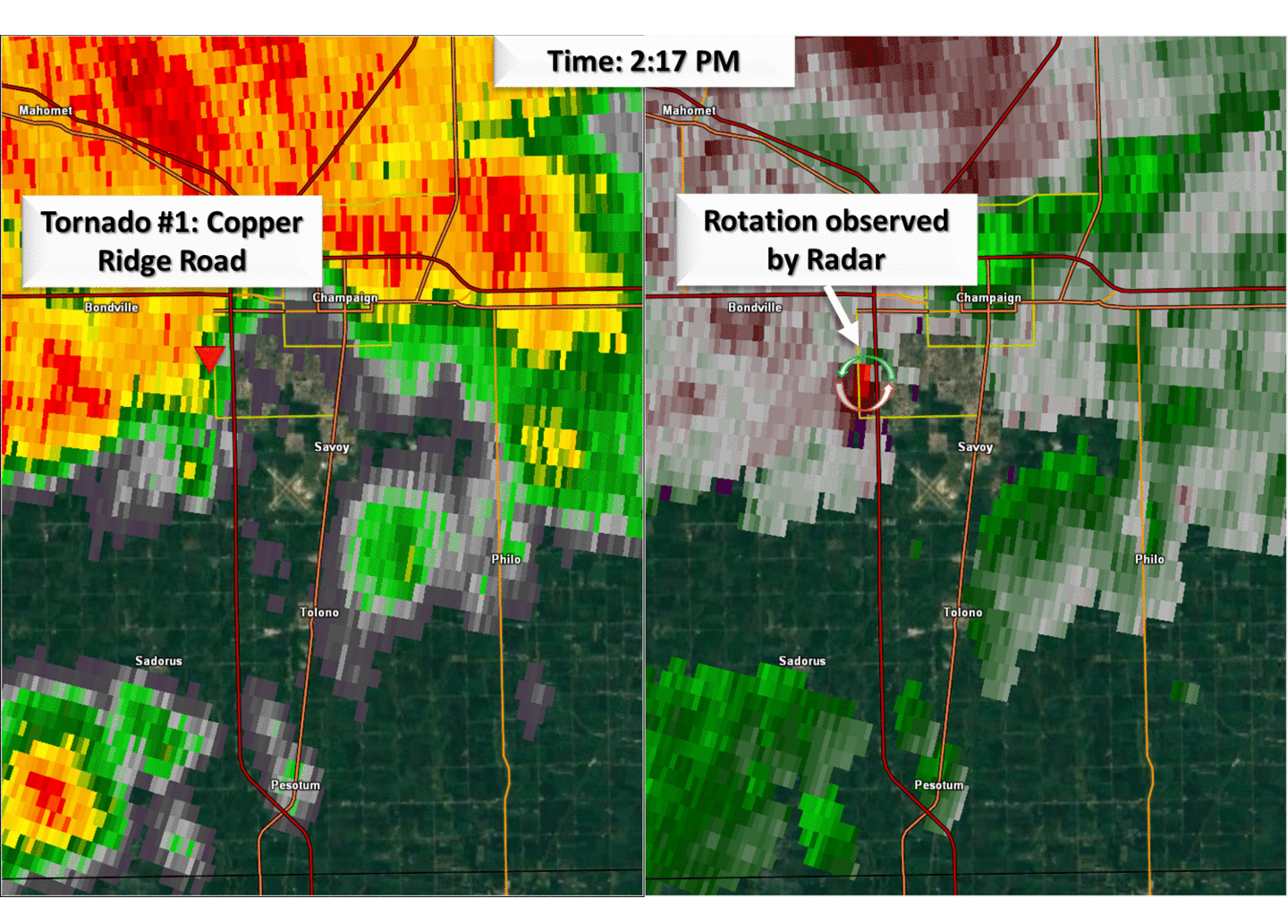
0216 PM TORNADO 3 SW CHAMPAIGN 40.08N 88.32W
06/10/2018 CHAMPAIGN IL NWS STORM SURVEY
SURVEY DETERMINED AN EF0 TORNADO DEVELOPED NEAR COPPER
RIDGE ROAD, ON THE SOUTHWEST SIDE OF CHAMPAIGN. THE
TORNADO DAMAGED ROOFS, A SHED, FENCING AND TREES. IT
DISSIPATED AFTER 0.1 OF A MILE.
0219 PM TORNADO 4 SSW CHAMPAIGN 40.07N 88.30W
06/10/2018 CHAMPAIGN IL NWS STORM SURVEY
DAMAGE SURVEY INDICATED AN EF0 TORNADO WAS ON THE GROUND
FOR ABOUT 0.1 MILE ON THE SSW EDGE OF CHAMPAIGN. THE
TORNADO TOUCHED DOWN NEAR DUNCAN RD AND ROLLING ACRES DR
DAMAGING TREES.
0220 PM TSTM WND DMG THOMASBORO 40.24N 88.19W
06/10/2018 CHAMPAIGN IL TRAINED SPOTTER
LARGE TREE LIMBS BLOWN DOWN
0220 PM TSTM WND DMG SW CHAMPAIGN 40.11N 88.26W
06/10/2018 CHAMPAIGN IL BROADCAST MEDIA
POWER POLES AND LINES DOWN NORTH OF DUNCAN AND CURTIS
ROADS. TIME ESTIMATED BY RADAR.
0223 PM TSTM WND DMG 1 SE SAVOY 40.05N 88.24W
06/10/2018 CHAMPAIGN IL EMERGENCY MNGR
13 POWER POLES BLOWN DOWN AT THE INTERSECTION OF COUNTY
ROAD 1200E AND 1100N. FROM COUNTY EMA.
0225 PM TSTM WND DMG 3 SW CHAMPAIGN 40.08N 88.32W
06/10/2018 CHAMPAIGN IL EMERGENCY MNGR
REPORTS OF NUMEROUS TREES AND POWER LINES DOWNED. AS WELL
AS SOME DAMAGE TO HOUSES.
0230 PM TSTM WND DMG PHILO 40.00N 88.16W
06/10/2018 CHAMPAIGN IL EMERGENCY MNGR
REPORT OF TREE DAMAGE AT JEFFERSON AND ADAMS.
0230 PM TSTM WND DMG PHILO 40.00N 88.16W
06/10/2018 CHAMPAIGN IL CO-OP OBSERVER
A 24INCH DIAMETER 40FOOT TALL TREE FELL ON 3 CARS.
0233 PM TSTM WND DMG 2 WNW PHILO 40.01N 88.20W
06/10/2018 CHAMPAIGN IL EMERGENCY MNGR
REPORT OF POWER LINES DOWN, AS WELL AS DAMAGE TO CORN
CROPS. TIME ESTIMATED BY RADAR.
0233 PM TSTM WND DMG 3 ESE PHILO 39.98N 88.11W
06/10/2018 CHAMPAIGN IL EMERGENCY MNGR
TREES REPORTED DOWN. AS WELL AS DAMAGE TO A GRAIN BIN AND
CROPS. TIME ESTIMATED BY RADAR.
0240 PM TSTM WND DMG 2 N VILLA GROVE 39.89N 88.16W
06/10/2018 CHAMPAIGN IL EMERGENCY MNGR
REPORT OF NUMEROUS TREES WITH TOPS SHEARED OFF AT COUNTY
ROAD 100 AND 130.
0249 PM HAIL JAMAICA 39.98N 87.80W
06/10/2018 E0.88 INCH VERMILION IL EMERGENCY MNGR
0253 PM TSTM WND DMG GEORGETOWN 39.98N 87.64W
06/10/2018 VERMILION IL EMERGENCY MNGR
REPORT OF A TREE DOWN ON A HOUSE...MAJOR DAMAGE TO HOUSE.
TIME ESTIMATED BY RADAR.
0258 PM TSTM WND GST 2 N ARCOLA 39.71N 88.30W
06/10/2018 E60.00 MPH DOUGLAS IL TRAINED SPOTTER
0300 PM TSTM WND DMG 2 SW DANVILLE 40.12N 87.65W
06/10/2018 VERMILION IL EMERGENCY MNGR
NUMEROUS REPORTS OF TREES AND POWER POLES DOWNED FROM
SOUTHWEST OF DANVILLE TO GEORGETOWN.
0300 PM TSTM WND DMG 2 N GEORGETOWN 40.01N 87.64W
06/10/2018 VERMILION IL EMERGENCY MNGR
REPORTS OF POWER POLES AND LINES DOWN.
0305 PM TSTM WND DMG BROADLANDS 39.91N 88.00W
06/10/2018 CHAMPAIGN IL EMERGENCY MNGR
LARGE TREE LIMBS...10 TO 12 INCHES IN DIAMETER...REPORTED
DOWNED AT 2ND AND 3RD STREETS.
0309 PM TSTM WND DMG TOLEDO 39.27N 88.24W
06/10/2018 CUMBERLAND IL TRAINED SPOTTER
LARGE TREE UPROOTED ON EAST JACKSON STREET.
0310 PM TSTM WND DMG 1 S HARRISTOWN 39.83N 89.06W
06/10/2018 MACON IL LAW ENFORCEMENT
POWER LINES BLOWN DOWN ON MERIDIAN STREET NORTH OF OLD
ROUTE 36. FROM COUNTY SHERIFF.
0323 PM TSTM WND GST DECATUR AIRPORT 39.83N 88.87W
06/10/2018 M53.00 MPH MACON IL ASOS
0327 PM TSTM WND DMG 9 SE PARIS 39.52N 87.57W
06/10/2018 EDGAR IL BROADCAST MEDIA
LARGE TREE LIMBS BLOWN DOWN
0337 PM TSTM WND DMG SIDNEY 40.02N 88.07W
06/10/2018 CHAMPAIGN IL EMERGENCY MNGR
THREE INCH DIAMETER BRANCHES THROUGHOUT CITY. GRAIN BIN
BLOWN DOWN AT 1876 COUNTY ROAD 700N. POWER LINE DOWN AND
TREE DAMAGE AT 1725 COUNTY ROAD 900N. FROM COUNTY
EMERGENCY MANAGER.
0442 PM HAIL BEARDSTOWN 40.01N 90.43W
06/10/2018 M1.75 INCH CASS IL BROADCAST MEDIA
PUBLIC REPORT OF GOLFBALL SIZED HAIL RELAYED THROUGH
BROADCAST MEDIA.
 |
Media use of NWS Web News Stories is encouraged! Please acknowledge the NWS as the source of any news information accessed from this site. |
|


 Follow us on YouTube