|
|
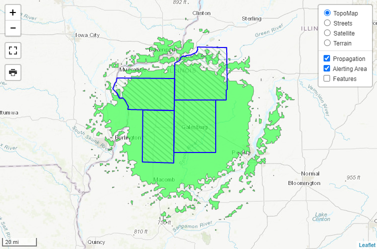
KZZ-66 serves 4 counties in west central Illinois:
Numbers in parentheses are used for the Specific Area Message Encoder (SAME), utilized by many NOAA Weather Radio receivers. The approximate coverage area is shown at left. This is based on computer projections, and may vary due to placement of your radio, direction of the transmitting antenna on the broadcast tower, and environmental issues. Click here for more details. Listeners in Henry County can also receive severe weather warnings on station WXJ-73 in Rock Island, and WXL-22 in Princeton. Knox County warnings also air on WXJ-71 in Peoria, and WXJ-92 in Macomb. Mercer County warnings also air on WXJ-73 in Rock Island, and WXN-83 in Burlington, IA. |
Routine Programming:
During adverse weather conditions, some normal programming is suspended. This is done to broadcast more important information frequently.
During severe thunderstorm and tornado watches, and flood warnings, the following will NOT air: Regional Weather Synopsis, Climate Summary.
Most normal programming is eliminated during severe thunderstorm and tornado warnings. Broadcast cycles are limited to severe weather watches and warnings, flood warnings, and Hourly Weather Roundup (local conditions only).
When a severe weather watch or warning is issued, it is preceded by special alarm signals, which activate specially designed weather radios. These radios will alert you to the warning broadcast, through use of a siren or other means of notification. Radios that have the alarm feature and a battery backup are highly recommended. The cost of these radios range around $20 and upward. Click here for more information about weather radio receivers.
The alarm features will be used for the following messages:
This alarm feature is tested on Wednesdays between 10 AM and 1 PM. If severe weather is a threat, the test will be held the first available good-weather day.
Local | Statewide Info | National | NWR-SAME | Receivers | Report Outage


 Follow us on YouTube