December 1, 2018
An historic tornado outbreak occurred across Illinois on December 1st, with a total of 29 tornadoes touching down across the central part of the state. Within the National Weather Service Lincoln County Warning Area (CWA), 20 tornadoes touched down...with the most significant being an EF-3 tornado that tore through the city of Taylorville in Christian County. Despite several communities being directly impacted and experiencing major damage, there were no fatalities reported.
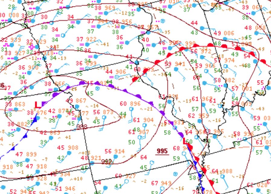
Surface analysis from 18z/12pm December 1st showed a 986mb low over northeast Kansas...with an occluded front arcing E/SE across eastern Missouri and a warm front lifting northward through central Illinois. The airmass north of the warm front remained cool and damp, as evidenced by widespread fog and midday temperatures in the lower 40s along and north of a Macomb to Minonk line. Further south into the warm sector, S/SE winds had helped boost temperatures into the upper 50s and lower 60s across the remainder of central and southeast Illinois. Dewpoints were unseasonably high as well, with readings climbing into the middle 50s.
SURFACE WEATHER MAP 18Z/12PM CST DECEMBER 1
While low clouds remained locked in place across much of the region, partial clearing occurred in southwest Illinois from the St. Louis metro northward to around Jacksonville. Based on mesoanalysis and high-resolution model data, it became apparent this area would be the focus for convective initiation by mid-afternoon. In order to better sample the destabilizing atmosphere, NWS Lincoln conducted a special 18z balloon launch. The upper air sounding revealed steep mid-level lapse rates of around 7C/km and Convective Available Potential Energy (CAPE) values of 500J/kg. In addition, ample 0-3km shear was present...due to winds shifting from SE at 15kt at the surface to S at 40kt about 1500ft aloft. In this case, both directional and speed shear were indicated. Note the turning of wind direction with height in the image below:
18Z DECEMBER 1 UPPER AIR SOUNDING FROM LINCOLN, IL

At 1:48PM CST, the Storm Prediction Center (SPC) issued a Mesoscale Convective Discussion (MCD) for the western half of central Illinois. They noted an increasing cumulus field over eastern Missouri ahead of the slowly approaching occluded front and suggested these newly forming cells would have sufficient instability and shear to work with to warrant a threat for hail, damaging winds, and tornadoes primarily after 21z/3pm. The main mitigating factor for widespread severe weather at this point was somewhat weak instability...with warm sector CAPEs of around 500J/kg. They felt these values would increase sufficiently for severe storm development over the next couple of hours.
1948Z MESOSCALE CONVECTIVE DISCUSSION (MCD)

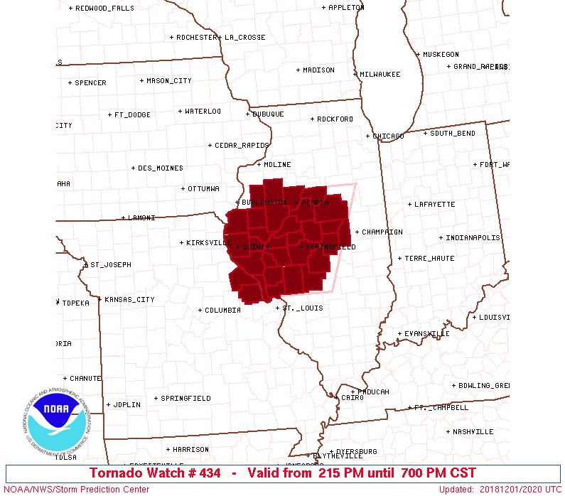
Shortly after the MCD was issued, SPC conducted a conference call with NWS Lincoln, St. Louis, Chicago, and Quad Cities. After collaborating with each local office and discussing the evolving situation, the decision was made to issue a TORNADO WATCH for a good portion of west-central Illinois. There was some doubt as to exactly how far north any thunderstorm cells could maintain severity, as a significant snow cover was still in place north of a Macomb to Minonk line. Despite the snow cover, it was decided to err on the side of caution and to include the northernmost counties of Knox and Warren in the watch. The watch was issued at 2:15 PM CST valid until 7:00 PM CST.
TORNADO WATCH #434
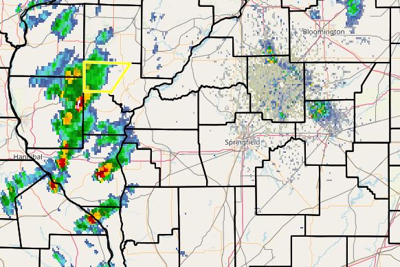
With cells rapidly developing between St. Louis and Quincy, the first WARNING issued by NWS Lincoln went out at 2:21 PM CST for western Schuyler County.
2:20PM CST RADAR IMAGE
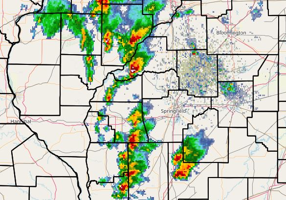
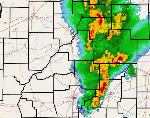
The initially warned storm tracked northward over the snow cover and eventually weakened in McDonough County. Meanwhile the cells further southwest began rotating as they skirted along the Illinois River from Pittsfield to just southwest of Pekin. Numerous warnings were issued for these cyclic supercells over the next couple of hours...with tornadoes touching down on the southeast side of Beardstown, just south of Lewistown in Fulton County, and between Easton and Forest City in Mason County. As the afternoon progressed, additional severe cells forming east of St. Louis began tracking northeastward toward Sangamon and Christian counties.
4:30PM CST RADAR IMAGE
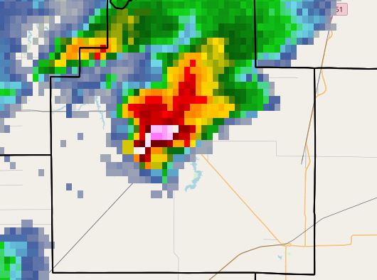
Two supercells over Montgomery County tracked into southern Christian County between 4:45pm CST and 5:00pm CST. The southernmost cell became the dominant storm and produced an EF-0 tornado southeast of Morrisonville. As this particular supercell cycled down and the first tornado dissipated, a second tornado touched down just east of Morrisonville at 5:01pm CST. With a spotter-confirmed tornado on the ground and heading toward Taylorville, NWS Lincoln decided to upgrade the previous tornado warning to a TORNADO EMERGENCY. Shortly afterwards, an EF-3 tornado tracked across the southern and western parts of Taylorville, creating severe damage. Below is a reflectivity image from 5:15PM CST. Note the well-defined hook echo just south of Taylorville.
5:15PM CST RADAR IMAGE
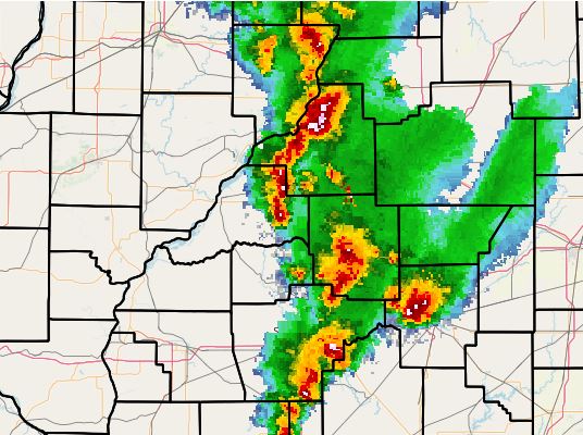
The parent supercell associated with the Taylorville tornado continued to track northeastward...periodically producing tornado touchdowns along its path across western Macon County, western DeWitt County into eastern McLean County. The radar imagery from 6:10pm CST below shows the storm passing west of Decatur.
6:10PM CST RADAR IMAGE
By 7:10pm CST, the storm had reached southeast McLean County and had just produced a brief tornado near Leroy.
After that, the cyclic supercell continued on a path across eastern McLean County...producing brief tornadoes near Moraine View State Park, southwest of Ellsworth, and west of Colfax before dissipating around 8:00PM CST.


 Follow us on YouTube