February 12-14, 2007 Snow Storm
A heavy snow event struck central Indiana on February 12th through the 14th, 2007. The snow began during the evening of February 12th, moving from the southwest to northeast across Central Indiana. The snow continued at Indianapolis for nearly 30 hours, and when it was all done, during the early morning hours of February 14th, Indianapolis had received 8.5 inches of snow.
Blowing and drifting of snow became problematic during the evening of February 13th and during the early morning hours of February 14th. Snow drifts caused the most problems in the areas that received the most snow, mainly north of Interstate 70.
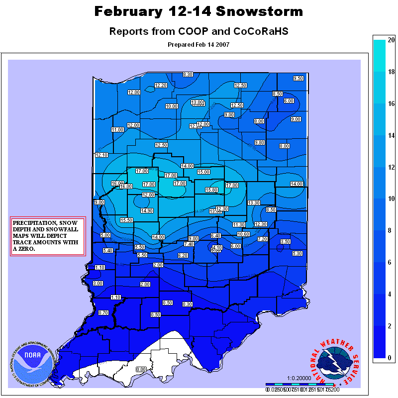
The low pressure system that produced the storm tracked along and south of the Ohio River across Kentucky which is an ideal storm track for heavy snow in central Indiana. Snow amounts with the storm were heaviest along a Lafayette to Muncie line. Many cities along this line received over a foot of snow. The largest amount of snow was measured in Lafayette, where 17 inches was measured by meteorologists at a television station. This ranks a tie for the second largest snowfall over a three day period in Lafayette. The largest snowfall in Lafayette was 20.5 inches on December 19-20, 1929.
A full map of snowfall reports from can be found here
Snowfall Reports:
|
Inches of Snow
|
Location
|
County
|
Time of Report
|
| 17.0 | Lafayette (WLFI-TV) | Tippecanoe | 445 AM |
|
15.0
|
Alexandria
|
Madison
|
952 PM
|
|
14.5
|
10 E Lafayette
|
Tippecanoe
|
800 PM
|
|
14.0
|
Attica
|
Fountain
|
800 PM
|
|
14.0
|
Frankfort
|
Clinton
|
800 PM
|
|
13.0
|
1 N Winchester
|
Randolph
|
342 PM
|
|
12.0
|
Kokomo
|
Howard
|
458 PM
|
|
11.8
|
2.9 NNE Muncie
|
Delaware
|
700 AM
|
|
11.0
|
Muncie
|
Delaware
|
126 PM
|
|
11.0
|
0.5 SSE Lebanon
|
Boone
|
600 AM
|
|
11.0
|
0.4 WNW Covington
|
Fountain
|
700 AM
|
|
10.0
|
4.6 SE New Castle
|
Henry
|
700 AM
|
|
10.0
|
4.5 NNE Lizton
|
Boone
|
700 AM
|
|
9.9
|
3.0 NE Lafayette
|
Tippecanoe
|
700 AM
|
|
9.0
|
4.0 ENE Kokomo
|
Howard
|
700 AM
|
|
9.8
|
Carmel
|
Hamilton
|
945 PM
|
|
9.3
|
4.6 S Brownsburg
|
Hendricks
|
700 AM
|
|
8.9
|
3.8 SE Beech Grove
|
Marion
|
700 AM
|
| 8.8 | Castleton | Marion | 1000 AM |
|
8.5
|
5 E Brownsburg
|
Marion
|
636 PM
|
|
8.5
|
5 NNW Indianapolis
|
Marion
|
538 PM
|
|
8.2
|
1.6 ESE Martinsville
|
Morgan
|
700 AM
|
|
8.0
|
3.2 E Indianapolis
|
Marion
|
700 AM
|
|
7.5
|
0.8 SW Shelbyville
|
Shelby
|
700 AM
|
|
7.0
|
5.2 E Greenwood
|
Johnson
|
700 AM
|
|
6.0
|
New Whiteland
|
Johnson
|
1030 PM
|
|
2.5
|
3.0 N Columbus
|
Bartholomew
|
700 AM
|
|
2.5
|
1.9 S Bloomington
|
Monroe
|
700 AM
|
|
1.7
|
0.3 WSW Sullivan
|
Sullivan
|
700 AM
|
|
0.8
|
0.4 NW Vincennes
|
Knox
|
700 AM
|
|
0.6
|
1.5 NW Washington
|
Daviess
|
700 AM
|
|
0.5
|
0.6 E Newberry
|
Greene
|
700 AM
|
|
0.4
|
4.8 ENE Mitchell
|
Lawrence
|
700 AM
|
|
T
|
3.4 NW Crothersville
|
Jackson
|
700 AM
|


 Follow us on YouTube