
Brandon/Rankin County Tornado
|
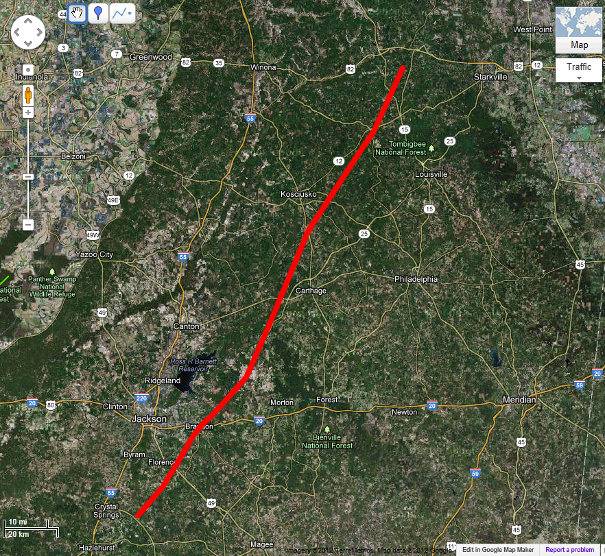
Event Summary The tornado first touched down in northeast Copiah County 1 mile north of Hopewell and moved northeast across extreme northwest Simpson County. At 11:37 pm the tornado moved into Rankin County, passing 1 mile southeast of Florence. The tornado moved through the southwest city limits of Brandon at 11:53 pm and continued northeast exiting the county 7 miles east of Sand Hill at 12:19 am. Then it moved into extreme northwest Scott County and into Leake County just north of Ludlow at 12:27 am. It continued across Leake County passing 6 miles west of Carthage and exited the county 1 1/2 miles north of Barnes at 12:56 am. It then continued through Attala County passing 10 miles east of Kosciusko and exited the county 2 miles east of McCool at 1:25 am. The tornado continued across Choctaw County passing through the town of Weir at 1:32 am, and began to slow its forward speed before dissipating 4 miles southwest of Mathiston at 2:01 am. |
|
||||||||||||||
| As the tornado moved across Copiah, Simpson, and extreme southwest Rankin County, it blew down many trees. The tornado then moved through a mobile home park in the south side of Florence. There it destroyed several mobile homes and damaged several other residences. Two people were killed in one of the mobile homes in Florence. The tornado then moved toward Brandon shortly before midnight. It struck another mobile home park where it destroyed 30 mobile homes and killed 4 people and injured many more. As the tornado moved through the south and east sides of Brandon it damaged or destroyed many more homes and mobile homes. It completely leveled a large, well built, brick home in the Easthaven subdivision and killed 4 people. In Rankin County a total of 60 homes were destroyed, over 500 homes were damaged, 10 people were killed, and 98 were injured. In Scott County most of the damage was to trees and power lines. There were several houses damaged around Ludlow. In Leake County the tornado destroyed 3 homes and damaged 9 others. it also destroyed 26 chicken houses and several farm buildings. One death occurred in Leake County in a mobile home in the Pine Tree community west of Carthage. In Attala County 36 homes were destroyed or severely damaged. Twelve people were injured. In Choctaw County 101 homes were damaged or destroyed. One person was killed in a mobile home in Weir and 12 others were injured. In all these counties timber damage was extensive. The tornado appeared to reach its maximum strength in Brandon where it was rated F4, but it had much F3 damage all along the path. | |||||||||||||||
Radar Imagery
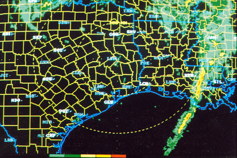
This regional radar image from 11:30 pm shows the storm as the tornado was passing from near Hopewell in Copiah County to the Old Pearl area of northwestern Simpson County. Radar image courtesy WSI. Click on the thumbnail below for a higher resolution image.
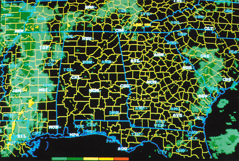
This regional radar image from midnight shows the storm as the tornado was passing through the city of Brandon in Rankin County. Radar image courtesy WSI. Click on the thumbnail below for a higher resolution image.
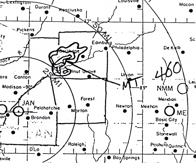
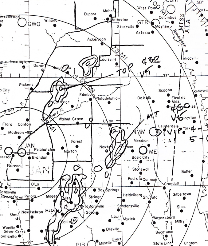
This is a radar overlay tracing from the Jackson WSR-57 radar at 12:30 am. This tracing shows the storm as the tornado was passing through southwestern Leake County. Click on the thumbnail below for a higher resolution image.
This is a radar overlay tracing from the Jackson WSR-57 radar at 1:25 am. At this time, the tornado is moving from eastern Attala County into Choctaw County. Click on the thumbnail below for a higher resolution image.


 Follow us on YouTube