Damage to the Jackson Metro Area |
||||
|
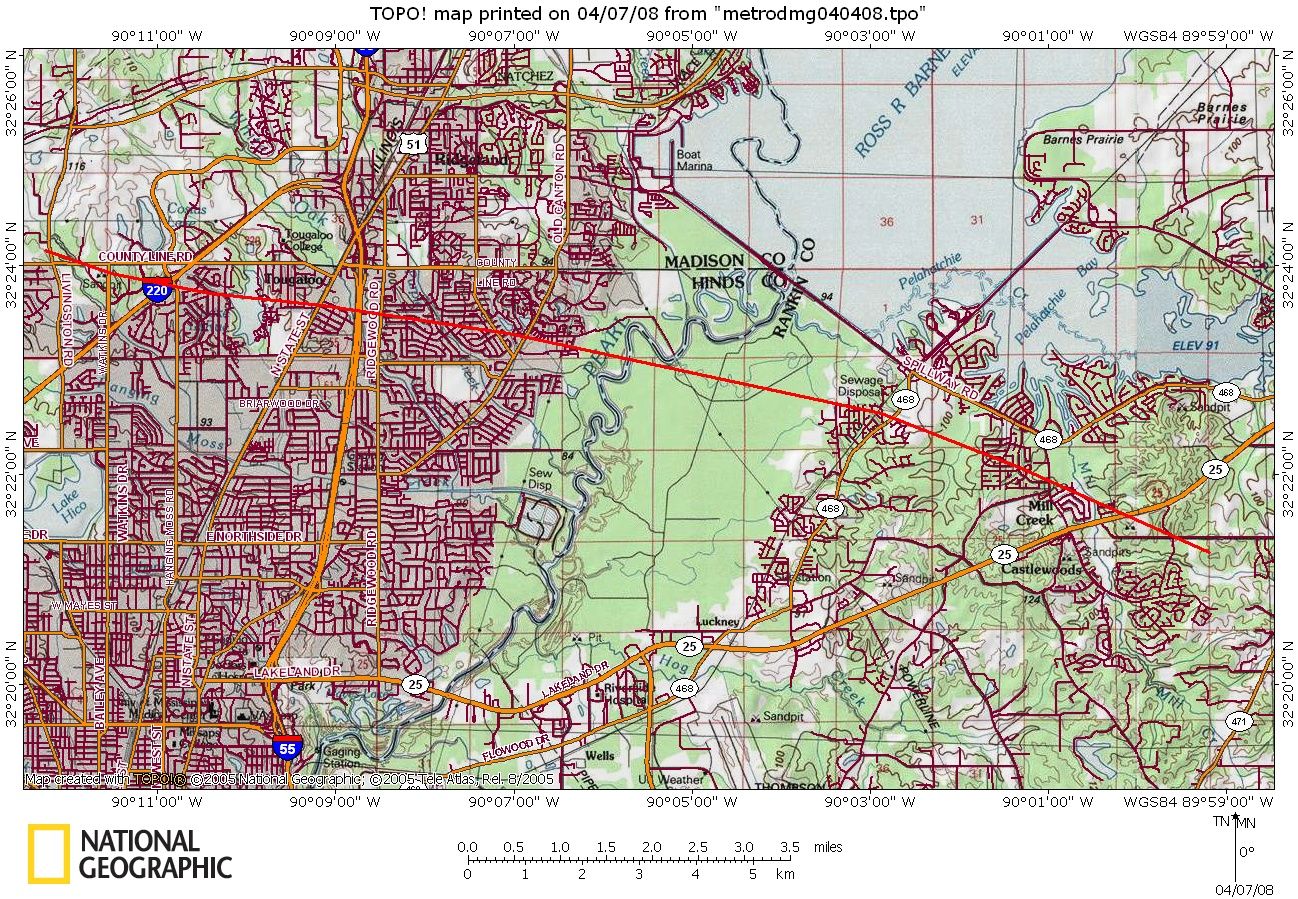
The NWS in Jackson conducted a survey of damage in the Jackson Metropolitan area today. While extensive straight line damage was found across parts of Hinds, Madison, and Rankin Counties, a strong tornado path was also found that ran from extreme southern Madison, across extreme northeast Hinds, and into northwestern Rankin Counties.
Beginning Point: near the intersection of Livingston and County Line Roads in extreme southern Madison county at 1229 PM CDT 4/4/08 Summary of Damage: The damage started with snapped trees, power lines and power poles across Livingston and County Line Roads and Watkins Drive. The tornado moved east-southeast, crossing Interstate 220 and downing numerous large trees, some on homes, as it moved through residential areas off Hanging Moss Road. Most of the damage in this area was EF-1 in nature with maximum winds between 90 and 105 mph. The damage became somewhat more intense as it moved through the Tougaloo area, with dozens of large trees snapped and uprooted, many on homes, causing serious damage. The tornado crossed State Street, and then crossed Interstate 55 where it caused roof damage to two hotels, and damaged a car dealership, snapping light poles, blowing the windows out of dozens of cars, and causing roof and awning damage. It also damaged the roof of a large medical building. As the tornado crossed Ridgewood Road, it blew out the back wall of a large restaurant building, and continued damaging roofs of buildings and knocking down numerous trees. The damage in the Interstate 55 area was rated as EF-1 with maximum winds between 95 and 105 mph. Once the tornado crossed Ridgewood Road, it moved back into residential areas of northeast Jackson. The tornado reached its maximum intensity as it approached and crossed Old Canton Road. Hundreds of large trees were snapped and uprooted in these areas, causing major damage to numerous homes. On the east side of Old Canton, it caused extensive roof and facade damage to several commercial buildings, blew the walls out of the second story of a large warehouse type building, and caused extensive damage to the roofs of apartment complex buildings and a couple of residential homes. This area along the path from just west of Pear Orchard Road to the area on the east side of Old Canton Road was the maximum rated damage at EF-2 with maximum estimated winds of 115 mph. While not accessible via ground survey, it is assumed based on radar data that the tornado continued on the ground across the Pearl River. Damage was again observed in northwest Rankin County in the subdivisions off of Old Fannin Road. Numerous trees were downed, a number on houses, and many homes had shingle damage. The most intense damage was where the tornado crossed Old Fannin Road in the Avalon and Barnett Bend subdivisions. Numerous large trees were snapped and uprooted, several causing major damage to some homes, and power poles were snapped off. Maximum winds here were estimated to be up to 105 mph, which is at the high end of EF-1 on the Enhanced Fujita scale. Damage was somewhat less as it moved through the subdivisions east of Hugh Ward Parkway, but intensified again as it moved along Manship Road and into Mill Creek subdivision. A number of large trees were snapped and uprooted in these areas. The tornado crossed Lakeland Drive, continuing to down trees, and moved across the Northwest Rankin Attendance Center complex, blowing down trees, a fence at the baseball field, and blowing out an awning. The tornado crossed Vine Drive and caused extensive shingle and roof damage to a number of apartment buildings. The tornado dissipated shortly after this damage, causing sporadic tree damage at the edge of Castlewoods subdivision. Maximum winds in the area from Hugh Ward Parkway to prior to dissipation were estimated to generally be between 90 and 100 mph, which is EF-1 on the Enhanced Fujita scale. It should be noted that extensive straight line wind damage was also observed by the survey team, particularly just to the south of the path of tornadic damage.
|
Damage Across the Metro Area |
|||
 |
 |
||
 |
 |
||
 |
 |
||
 |
 |
||
-->


 Follow us on YouTube