The second week of January 2008 was quite active with respect to severe weather. Two events impacted the region in a span of 3 days which produced several tornadoes, large hail and wind damage across the area.
On January 10th a vigorous storm system developed over the southern portions of the Midwest and moved northeast towards the Ohio valley. A strong cold front swept across the area during the late morning into the afternoon hours and strong to severe thunderstorms developed out ahead of it. All of the ingredients for tornadic development came into place as warm Gulf moisture pushed northward into the area out ahead of the front. The thunderstorms developed in eastern Louisiana and quickly moved across central Mississippi during the late morning and afternoon hours. As the storms progressed eastward, good instability combined with very strong wind shear for supercell development east of the Mississippi River, with the storms reaching maximum intensity along and east of the interstate 55 corridor.
Teams of National Weather Service meteorologists, with assistance from state and local emergency management officials, have been working to record and analyze storm damage across the area. After surveying the tracks of several severe storms across the area, the NWS has determined that eight tornadoes were produced across the central third of Mississippi by those storms.
By far, the most damage was produced by a single "supercell" thunderstorm that moved from north of Vicksburg through north central and northeast Mississippi during the late morning and early afternoon hours. This single storm produced three strong tornadoes, all of which were rated as EF3 on the Enhanced Fujita tornado damage scale. The most significant damage occurred in Caledonia in Lowndes County, where a school gymnasium was destroyed along with a number of school buses and vehicles in the area. Even though the school complex had 1900 people in it at the time of the tornado, only three minor injuries were reported at that location. A tornado warning was issued for this area by the NWS in Jackson about 39 minutes before the tornado developed to the southwest of Caledonia, and approximately 41 minutes before the damage occurred at the school in Caledonia.
The longest track tornado from this event occurred in eastern Attala and Choctaw Counties. A tornado tracked for 24 miles from just west of the Ethel community in Attala County to about two miles south of Ackerman in Choctaw County. This was the tornado responsible for heavy damage to a dairy complex south of the Weir community. This is the longest track for a tornado in the central Mississippi region since the tornado outbreak of November 24, 2001.
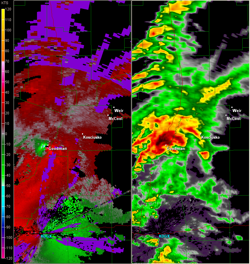
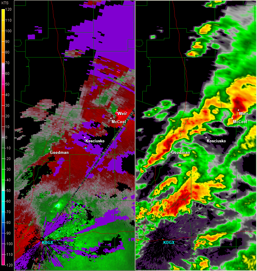
The low-level circulation associated with this first supercell intensified as it approached Goodman in Holmes County, and it was apparent that a strong tornado had formed (KDGX radar image at 11:56AM). This intense circulation remained apparent in western Attala County near Sallis (KDGX radar image at 12:05PM), and in northeast Attala County from near McCool along the Natchez Trace Parkway into Choctaw County (KDGX radar image at 12:48PM).
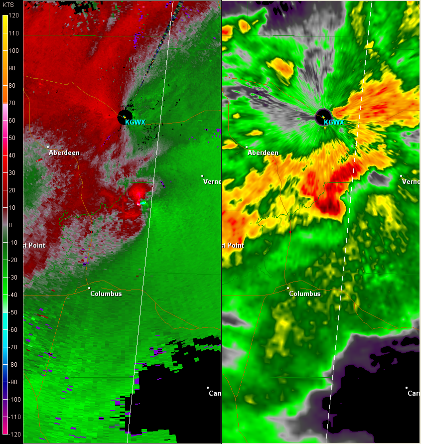
The low-level circulation reintensified upon entering northern Lowndes County in the Columbus AFB vicinity (KGWX radar image at 2:07PM) where severe wind gusts greater than 60 mph were observed. A strong tornado touched down near Caledonia (KGWX radar image at 2:16PM) before moving east into Alabama.
A second supercell that organized near the Mississippi River in southwest Mississippi before midday tracked from Claiborne County, through the northern Jackson Metropolitan Area, and finally into Noxubee county in northeast Mississippi by mid afternoon. This storm was responsible for 5 different tornado touchdowns along its path, as well as many reports of high winds and hail. National Weather Service storm survey teams rated these tornadoes as EF0s and EF1s and a majority of the relatively minor structural damage associated with them occurred just southwest of the Pearl River Resort in Neshoba County.
The National Weather Service would like to thank officials from MEMA and the affected counties` Emergency Management Directors for their assistance in performing these damage surveys.
*NOTE: All radar images are 0.5 degree, Storm Relative Velocity and Reflectivity.
Damage Reports


 Follow us on YouTube