
Event Summary
A potent storm system combined with abundant moisture over the ArkLaMiss region to bring nearly 24 hours of showers and thunderstorms, beginning during the day March 8th and continuing through the early morning hours of March 9th. With rich moisture flowing north from the Gulf of Mexico, many of the storms were efficient rain producers, bringing the risk of flash flooding and river flooding. Many locations along and southeast of the Natchez Trace Parkway corridor had already seen as much as 3 to 4 inches of rain just 3 to 4 days prior to this event. Along with the flooding, ample wind shear and strong forcing from an upper disturbance and approaching cold front brought a risk for severe thunderstorms. The primary hazards from these thunderstorms would be from damaging winds and tornadoes. The best combination of shear and instability would be south of Interstate 20.
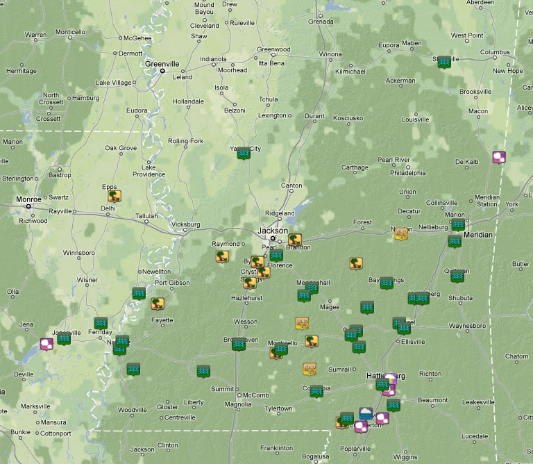
Showers began to affect the ArkLaMiss region during the morning of the 8th. These showers increased in coverage and intensity during the afternoon and evening hours. Thunderstorms moved repeatedly over the same locations, which allowed rainfall amounts to add up quickly. Numerous flash flood warnings were issued and reports of water covering roadways, along with water rescues were receieved by NWS Jackson. This additional rainfall rose water levels on area rivers, causing several to go above flood stage and many others expected to go into flood over the next several days. As the upper disturbance moved closer to the region, some storms became severe with a few storms exhibiting small, tight rotation on radar. Reports of trees and powerlines down, along with some structural damage occurred in Hinds County around Terry. The image below depicts some of the storm reports received.
Local Storm Reports
Survey Information -

Click on the Location in the Table for additional Details
| Location | Start/ End Time |
Event Type | Fatalities/ Injuries |
Path Length | Path Width |
| Hinds County 3 miles NW Terry to 5 miles NNW Terry |
Wed 3/9/2011 1:34 am - 1:37 am |
EF-2 115 mph |
0 | 3 miles | 150 yds |
| Hinds County 1 mile NNE Utica to 1 mile W Learned |
Wed 3/9/2011 1:08 am - 1:14 am |
EF-1 95 mph |
0 | 6 miles | 250 yds |
| Jones County (Click here for Flooding Pictures) | Tues 3/8/2011 | Flooding | 0 |
Rainfall Totals
Storm-total rainfall amounts were quite high as storms moved repeatedly over the same locations. Amounts as high as 7 to 7.5 inches were reported south of Meridian and in Quitman.


 Follow us on YouTube