
Scott and Newton County Tornado
Click on the map above for a detailed, interactive track map and damage pictures.
|
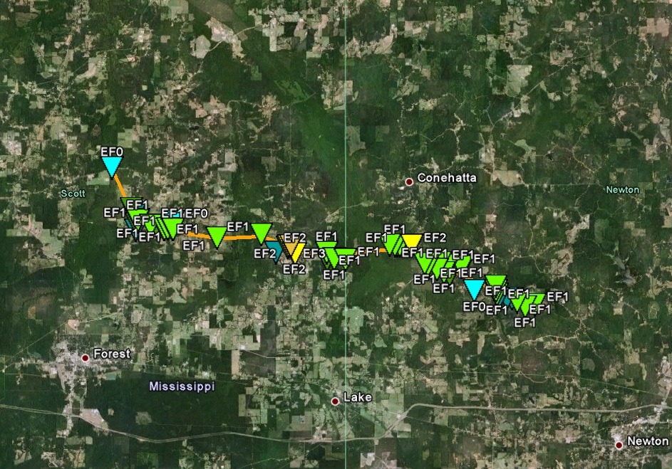
Event Summary This tornado began along Old Jackson Road east of Hillsboro. Initially the tornado tracked southeast downing multiple trees as it crossed Harrison Road and MS Highway 21. There were also a few homes with roof damage in this area and outbuildings damaged by fallen trees. The tornado then began a more easterly course along Greer Road and began to snap and uproot several additional trees as it crossed Ephesus Road, Langsmill Road, and Russell Community Road. Along Russell Community Road multiple trees fell on structures, including one that fell through a home causing an injury. The tornado continued eastward, downing additional trees and caused minor roof damage at a residence on George Road. |
|
||||||||||||||
|
As the tornado reached the Lewis Road area, there was a notable increase in the number of hardwood trees that were snapped along the path. Along the northern end of the track...part of the roof of a small barn was removed. Extensive tree damage continued to the Salem Road area, where the tornado reached its peak intensity of around 140 mph. At this location three large steel transmission towers were bent toward the ground between Salem Road and Jim Owens Road. Along Jim Owens Road, a large shed and a travel trailer were demolished. Farther east the tornado blew a mobile home into the roadway at Conehatta Road. The roof and walls were separated from the undercarriage and the contents of the home were scattered in the area. There were two occupants in the home at the time, and both escaped without significant injury. Along Stroud Road portions of the roof of an outbuilding were removed and a small silo was blown over before the tornado crossed into Newton County. |
|||||||||||||||


 Follow us on YouTube