April 2-3, 2017 Severe Weather and Flood Event
Event Summary
A large storm system brought a large encompassing severe weather and flooding event across a large portion of the ArkLaMiss region. A fast moving trough moved down into the desert southwest into west Texas by Sunday morning. This helped a warm front gradually lift back to the north through the afternoon. This brought increasing moisture and instability across our western areas by early to mid Sunday afternoon. A strongly unstable and sheared atmosphere supported severe weather, including large hail, damaging winds and tornadoes. A total of 5 tornadoes developed across portions of northeast Louisiana during the afternoon hours, with 3 EF1s and 2 EF2 (strong) tornadoes across northeast Louisiana. Three injuries occurred throughout the afternoon hours but thankfully no fatalities occurred. A squall line continued into the northwest Delta by mid-late afternoon, leading to a 69mph wind gust at the Greenville Airport. As the upper trough quickly moved northeast, the low pressure slowly became stronger over central Plains, leading to the cold front moving towards the area by late Sunday night to early Monday morning. This brought another round of severe weather across the region, with many severe storms, including damaging winds and another tornado (EF1) occurring just after midnight in south-central Mississippi.
In addition, anomalous amounts of moisture in the atmosphere were being brought in advance of the cold front, leading to extremely torrential rainfall. Training of rain over the region led to widespread rainfall totals of 3-10 inches, with up to 6-10 inches in the Interstate 20 corridor by Monday morning. This led to massive flash flooding in Warren County near Vicksburg, portions of Hinds County and especially Rankin and Scott County. In Rankin County, many locations flooded, including Laurel Park Apartments, Castlewoods subdivision, Mill Creek area, and Williams Road in Florence. This led to many widespread evacuations and water rescues across the Interstate 20 corridor. Sadly, one fatality occurred just off of Highway 469 in Florence where a car was swept off the road into a creek. All of the rain and storms moved out of the region by mid-morning before the cold front moved through by mid-afternoon.
Tornado Track Map
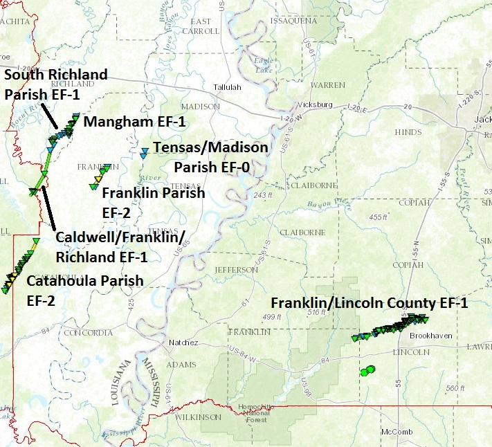
Northeast Louisiana Tornado Track Map
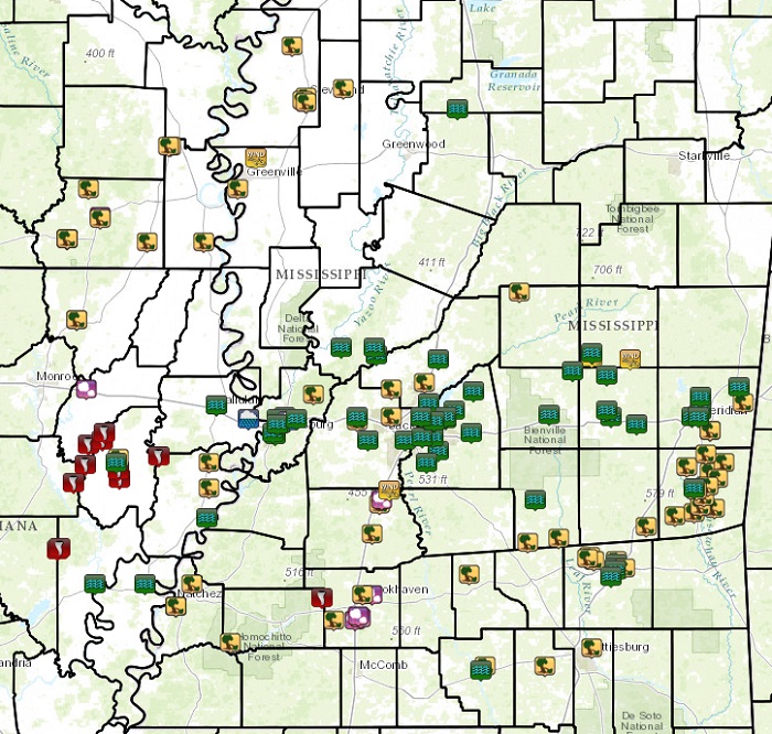
Local Storm Reports
Click on the map for additional details.

Precipitation Summary
Rainfall Across the Region: April 2-3, 2017
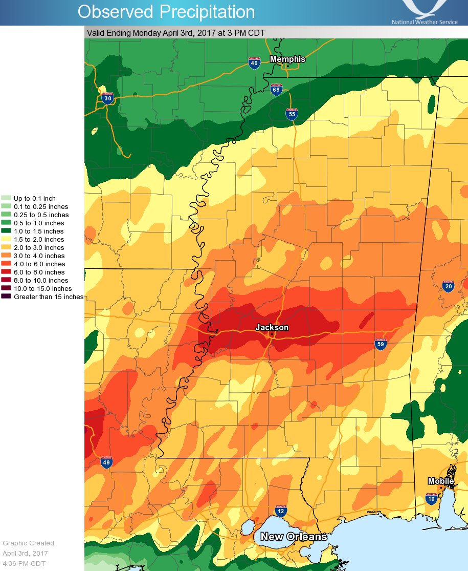
Rainfall Totals
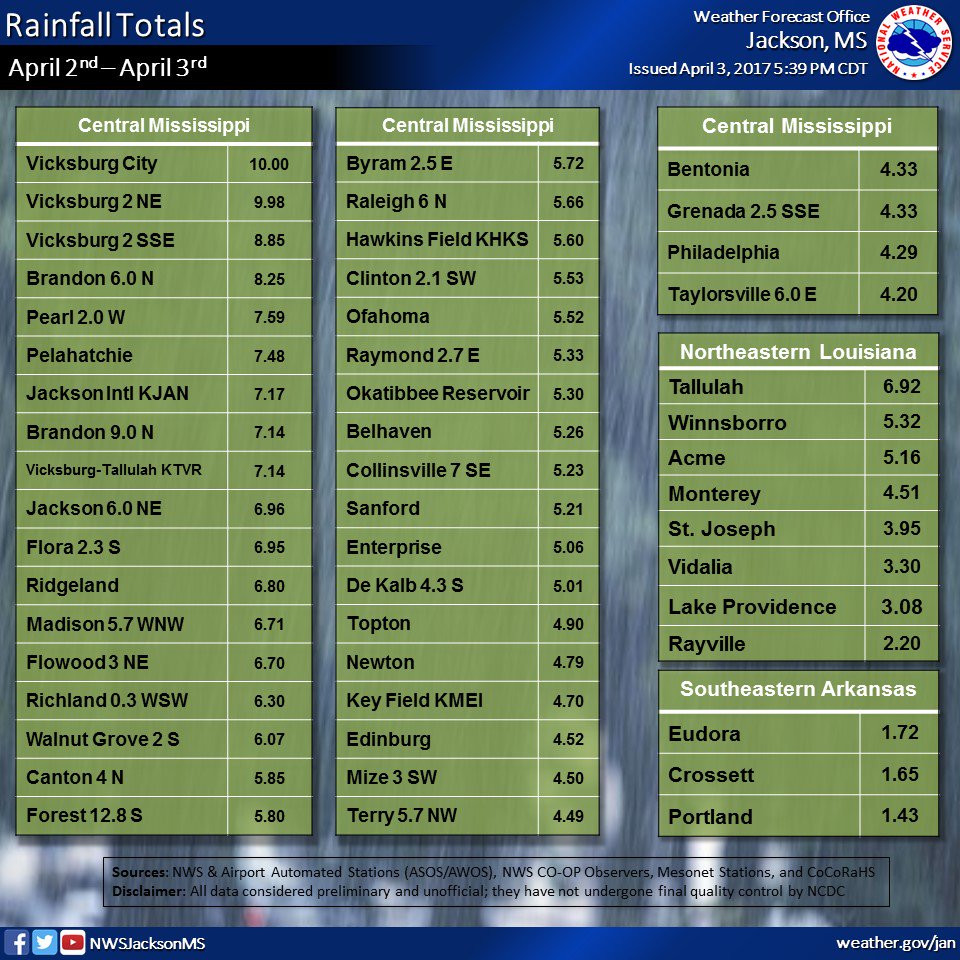
Click on the location in the table for additional maps and details below.
| Location | Start/ End Time |
Event Type | Fatalities/ Injuries |
Path Length | Path Width |
| Caldwell/Franklin/Richland parishes 8 ESE Columbia to 6 WSW Baskin |
4:17 PM - 4:46 PM |
EF-1 Tornado 110 mph |
none | 13.23 miles | 7/10 mile |
| La Salle/Catahoula parishes 6 NE Jena to 10 NNW Harrisburg |
4:28 PM - 4:42 PM |
EF-2 Tornado 115 mph |
Injuries: 1 | 13.79 miles | 1/2 mile |
| Richland Parish 6 SW Mangham to 3 SSW Mangham |
4:48 PM - 4:53 PM |
EF-1 Tornado 105 mph |
none | 3.69 miles | 300 yards |
| Richland Parish 2 W Baskin to 2 NE Mangham |
4:49 PM - 4:59 PM |
EF-1 Tornado 105 mph |
none | 4.86 miles | 1/2 mile |
| Franklin Parish 3 NW Gilbert to 5 E Winnsboro |
5:09 PM - 5:22 PM |
EF-2 Tornado 115 mph |
Injuries: 2 | 5.83 miles | 0.35 mile |
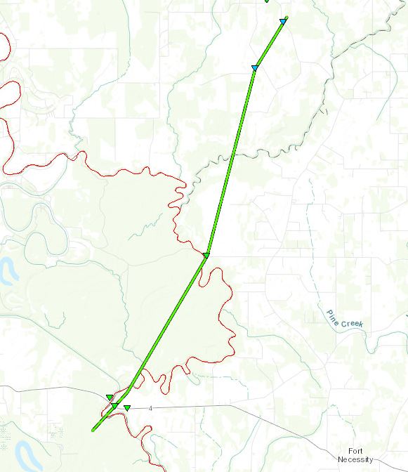
| Tensas and Madison parishes 13 NE Gilbert to 14 ENE Winnsboro |
5:41 PM - 5:44 PM |
EF-0 Tornado 80 mph |
none | 1.4 miles | 100 yards |
| Franklin and Lincoln counties 11 W Brookhaven to 4 SSE Wesson |
12:57 AM - 1:22 AM |
EF-1 Tornado 110 mph |
none | 17.48 miles | 0.6 mile |
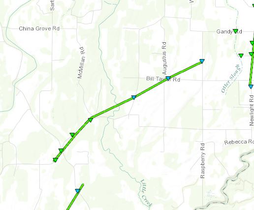
Franklin/Richland Parish EF-1 Tornado
Click on map above to see entire damage point notation and damage pictures at select points.
|
Track Summary This tornado touched down just to the west in Caldwell Parish before crossing into western Franklin Parish. A tornadic debris signature (TDS) was noted from the KULM radar. The tornado was quite wide at this point, nearly 1200 yards or three-quarters of a mile. It crossed Highway 4, snapping numerous trees in the path and tearing tin off the roof of a home. The tornado continued north-northeast back into Caldwell Parish. Wooded area prevented further access to this region but damage was seen through the distance. The TDS was still noted from the KULM radar through this area. The tornado continued north-northeast, moving back into Richland Parish, crossing LR Hatton Road, before crossing into a wooded area and the Franklin-Richland Parish line. The tornado continued north-northeast over Maple Ridge Road, Sligo Road and Goldmine Road. Numerous large trees were snapped and uprooted all through this area. The tornado then crossed LA Highway 135, where a couple of trees were snapped, before lifting shortly after crossing the road. |
|
Radar Imagery
These images from the Monroe radar, courtesy of the University of Louisiana-Monroe, show the storm at 4:27 pm as it crossed into far western Franklin Parish. The image on the left shows 0.7° base reflectivity data, and the image on the right shows 0.7° storm relative velocity data. Click on the thumbnail below for a higher resolution image.
La Salle/Catahoula Parish EF-2 Tornado
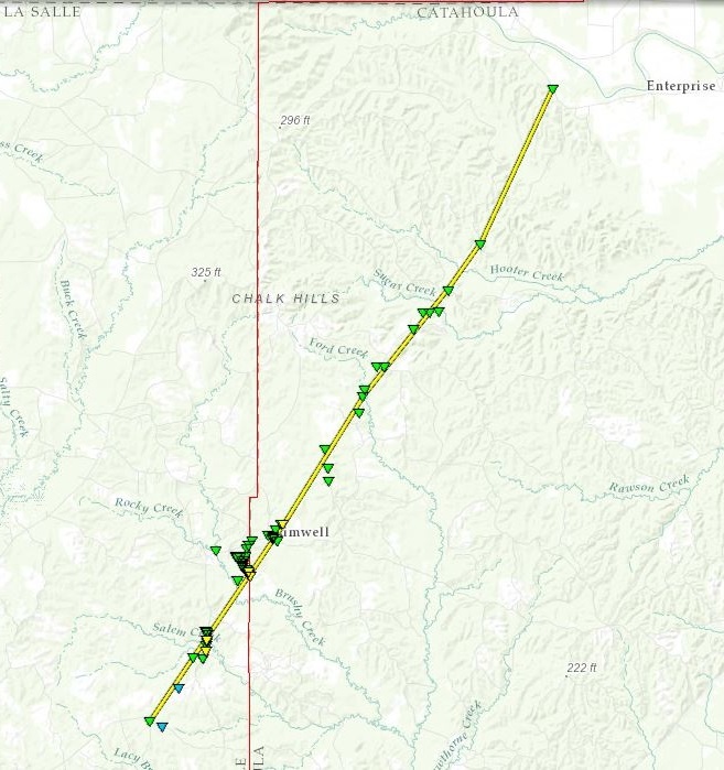
Click on map above to see entire damage point notation and damage pictures at select points.
|
Track Summary |
|
Radar Imagery
These images from the Fort Polk, LA Doppler radar show the storm at 4:33 pm as the tornado moved between Aimwell and Enterprise. The image on the left shows 0.5° base reflectivity data, and the image on the right shows 0.5° storm relative velocity data. Click on the thumbnail below for a higher resolution image.

Southern Richland Parish EF-1 Tornado
Click on map above to see entire damage point notation and damage pictures at select points.
|
Track Summary |
|
Radar Imagery
These images from the Monroe radar, courtesy of the University of Louisiana-Monroe, show the storm at 4:49 pm as it tracked southwest of Mangham. The image on the left shows 0.7° base reflectivity data, and the image on the right shows 0.7° storm relative velocity data. Click on the thumbnail below for a higher resolution image.

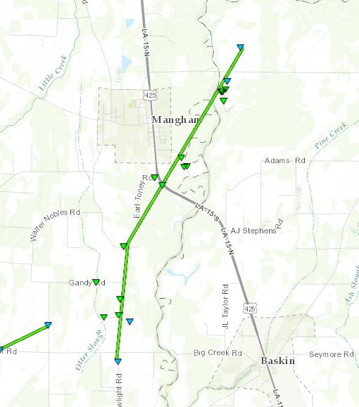
Click on map above to see entire damage point notation and damage pictures at select points.
|
Track Summary |
|
Radar Imagery
These images from the Monroe radar, courtesy of the University of Louisiana-Monroe, show the storm at 4:53 pm as the tornado approached US Highway 425 just south of Mangham. The image on the left shows 0.7° base reflectivity data, and the image on the right shows 0.7° storm relative velocity data. Click on the thumbnail below for a higher resolution image.

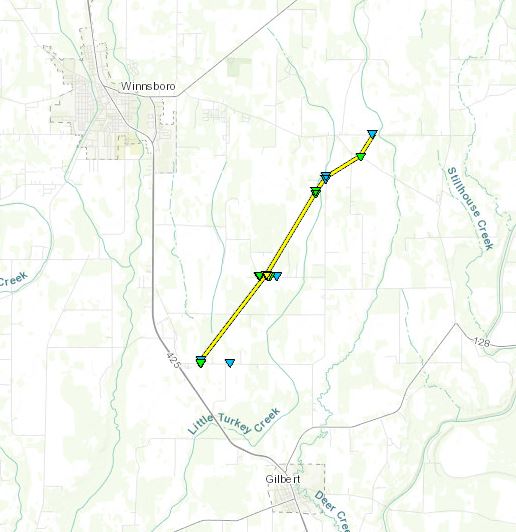
Click on map above to see entire damage point notation and damage pictures at select points.
|
Track Summary |
|
Radar Imagery
These images from the Monroe radar, courtesy of the University of Louisiana-Monroe, show the storm at 5:19 pm as the tornado passed between Winnsboro and Gilbert, east of the Chase community. The image on the left shows 0.7° base reflectivity data, and the image on the right shows 0.7° storm relative velocity data. Click on the thumbnail below for a higher resolution image.

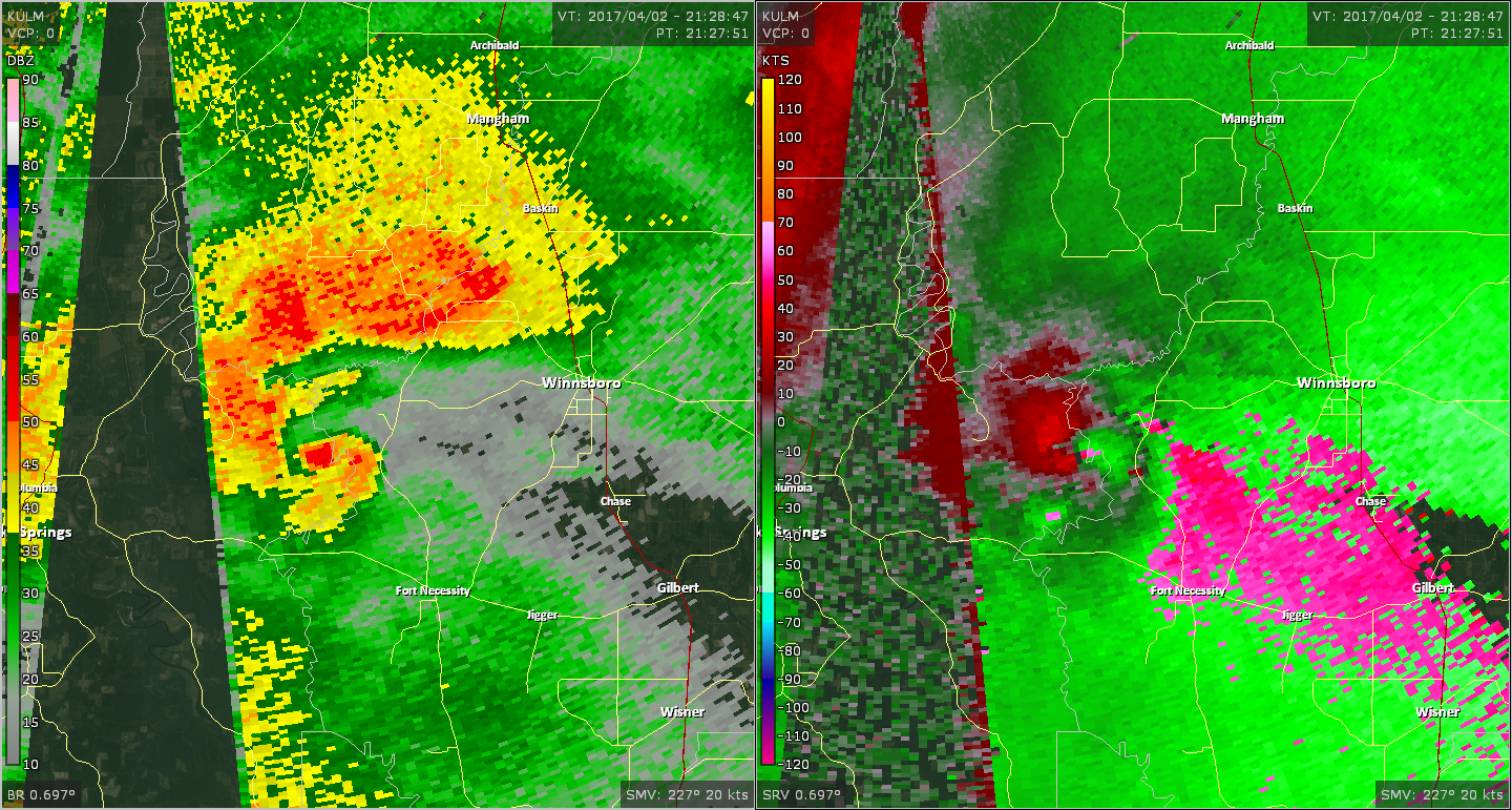
NW Tensas/SW Madison Parish EF-0 Tornado
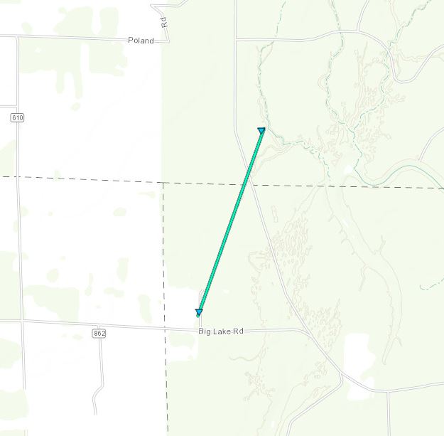
Click on map above to see entire damage point notation and damage pictures at select points.
|
Track Summary |
|
Radar Imagery
These images from the Monroe radar, courtesy of the University of Louisiana-Monroe, show the storm at 5:43 pm as the tornado moved into far southwest Madison Parish. The image on the left shows 0.7° base reflectivity data, and the image on the right shows 0.7° storm relative velocity data. Click on the thumbnail below for a higher resolution image.

E Franklin/N Lincoln County EF-1 Tornado
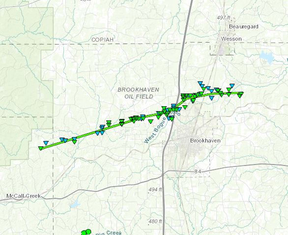
Click on map above to see entire damage point notation and damage pictures at select points.
|
Track Summary |
|
Radar Imagery
These images from the Brandon, MS Doppler radar show the storm at 1:13 am as the tornado moved north of Brookhaven. The image on the left shows 0.5° base reflectivity data, and the image on the right shows 0.5° storm relative velocity data. Click on the thumbnail below for a higher resolution image.


 Follow us on YouTube