April 13th &14th, 2018 Severe Weather Event
Event Summary
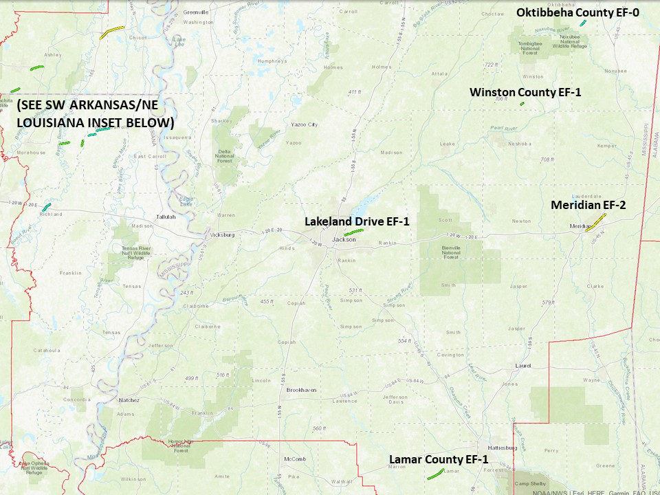
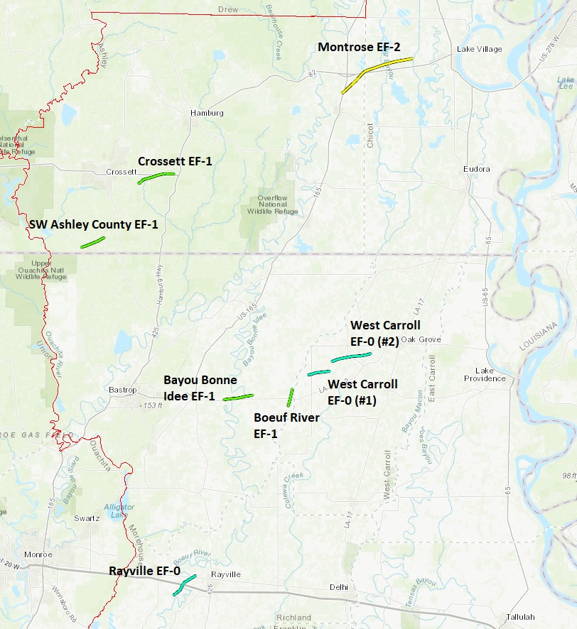
During the evening hours of Friday, April 13th, scattered supercells developed across northeast Louisiana within the broad warm sector of a strong surface cyclone centered near the Kansas/Nebraska border. These storms exhibited rotation almost immediately, and began producing tornadoes across northern Louisiana. Two tornadoes occurred in the NWS Jackson forecast area in association with a cell that tracked from near Rayville, LA north northeastward along the Boeuf River. These storms also produced strong wind as they continued into southeast Arkansas. Overnight, as the cold front associated with the storm system began to advance eastward, a quasi-linear convective system developed over the ArkLaTex and advanced eastward. These storms reached the western portion of the NWS Jackson forecast area after 2:30 am on Saturday, April 14th. Six tornadoes occurred during the early morning hours across southeast Arkansas and northeast Louisiana in association with this line of storms. The storms continued to produce damaging straight-line winds, knocking down trees and power lines in many areas, through the morning hours as it continued eastward into Mississippi. A few additional tornadoes also developed along the line, including one in Flowood, one near Noxapater, one in western Lamar County, and an EF2 tornado in Meridian.
Tornado Damage Map
Local Storm Reports
Click on the map for additional details.

| Location | Start/ End Time |
Event Type | Fatalities/ Injuries |
Path Length | Path Width |
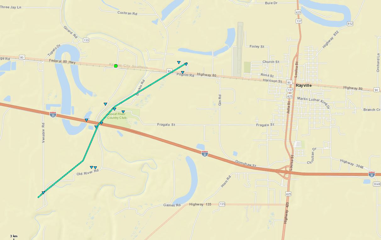
| Richland Parish 4 WSW Rayville to 2 WNW Rayville |
9:00 PM - 9:06 PM |
EF-0 Tornado 75 mph |
none | 3.28 miles | 400 yards |
| Morehouse/West Carroll Parish 10 W Pioneer to 10 WNW Pioneer |
9:46 PM - 9:50 PM |
EF-1 Tornado 95 mph |
none | 1.9 miles | 200 yards |
| Southwest Ashley County 8 SSW Crossett to 7 S Crossett |
2:42 AM - 2:47 AM |
EF-1 Tornado 100 mph |
none | 2.73 miles | 600 yards |
| West Central Ashley County 4 E Crossett to 6 SSW Hamburg |
2:53 AM - 2:58 AM |
EF-1 Tornado 100 mph |
none | 4.16 miles | 300 yards |
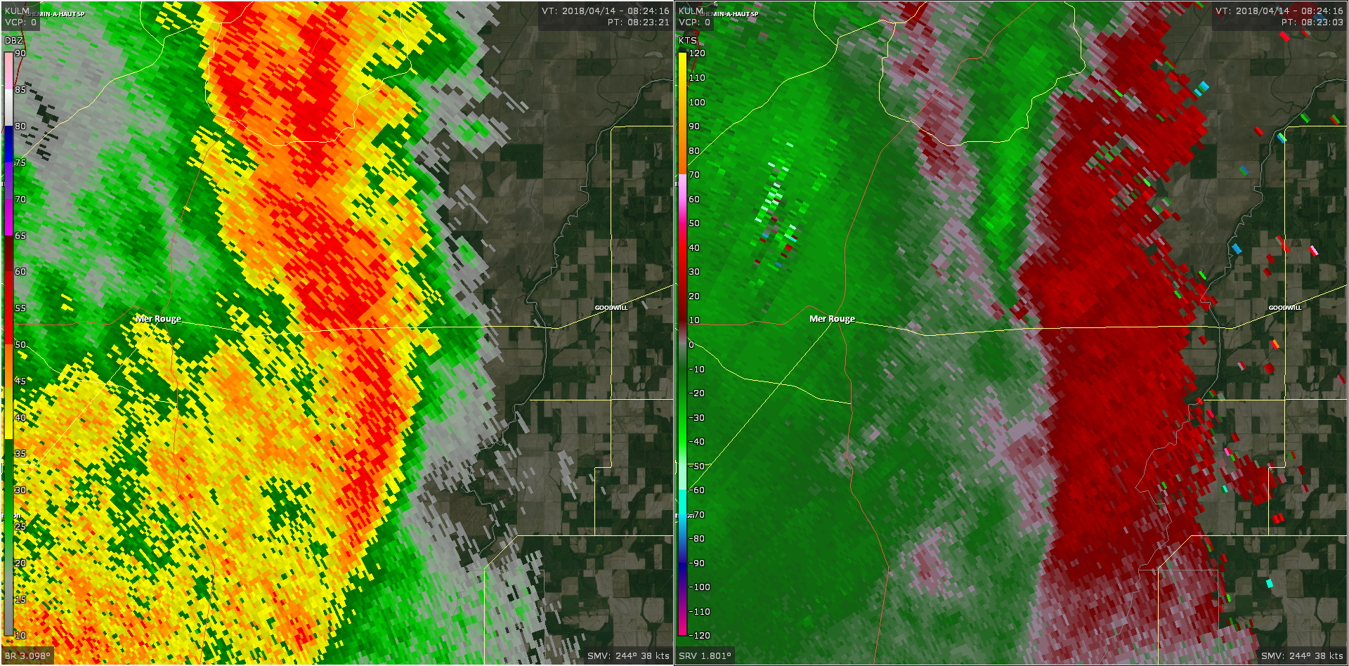
| Morehouse Parish 4 E Mer Rouge to 7 E Mer Rouge |
3:21 AM - 3:25 AM |
EF-1 Tornado 95 mph |
none | 3.19 miles | 200 yards |
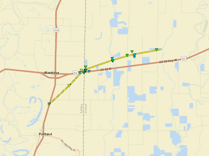
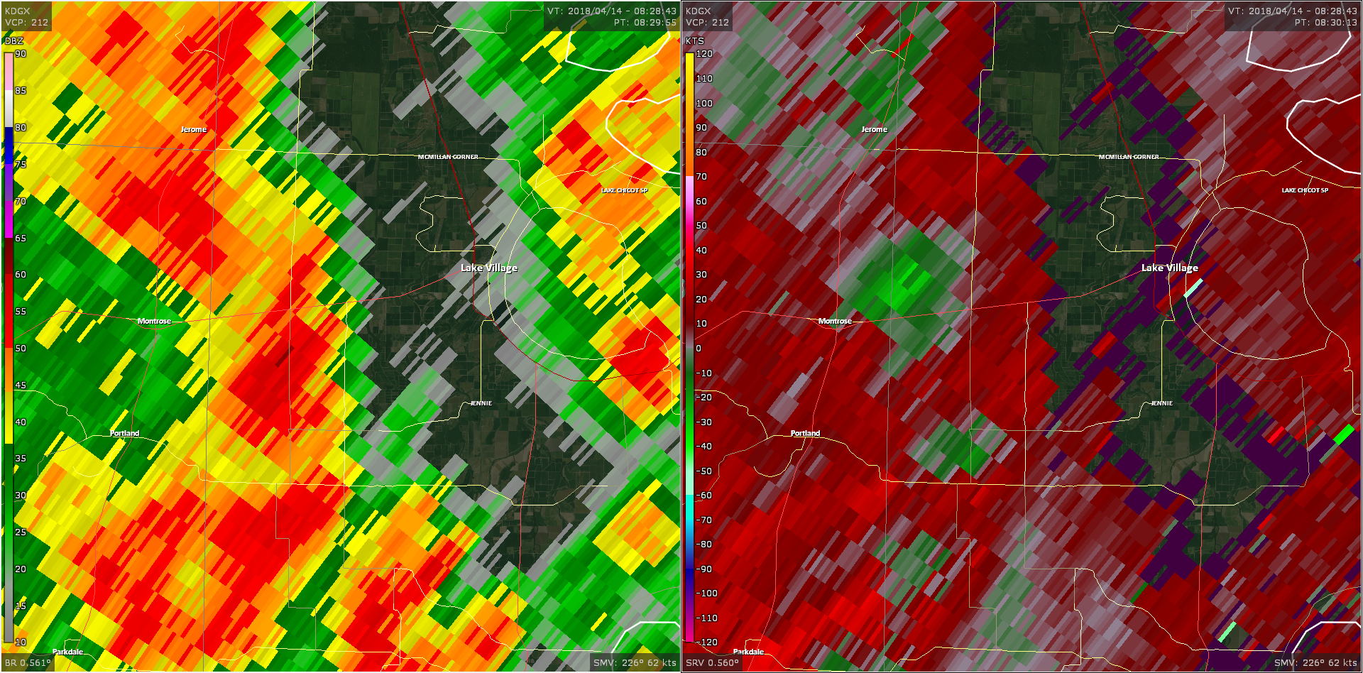
| Ashley/Chicot County 2 NNE Portland to 5 W Lake Village |
3:22 AM - 3:34 AM |
EF-2 Tornado 115 mph |
none | 8.93 miles | 700 yards |
| West Carroll Parish 9 WNW Pioneer to 7 WNW Forest |
3:33 AM - 3:36 AM |
EF-0 Tornado 85 mph |
none | 2.39 miles | 200 yards |
| West Carroll Parish 7 WNW Pioneer to 4 WSW Oak Grove |
3:36 AM - 3:42 AM |
EF-0 Tornado 85 mph |
none | 4.38 miles | 200 yards |
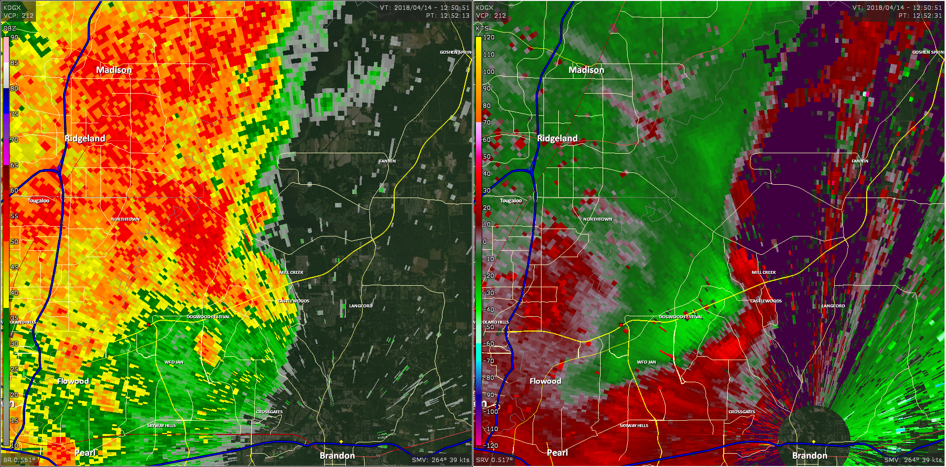
| Rankin County 1 N Flowood to 5 N Brandon |
7:44 AM - 7:55 AM |
EF-1 Tornado 90 mph |
none | 6.15 miles | 50 yards |
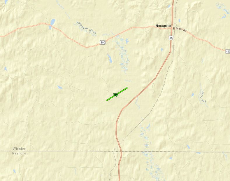
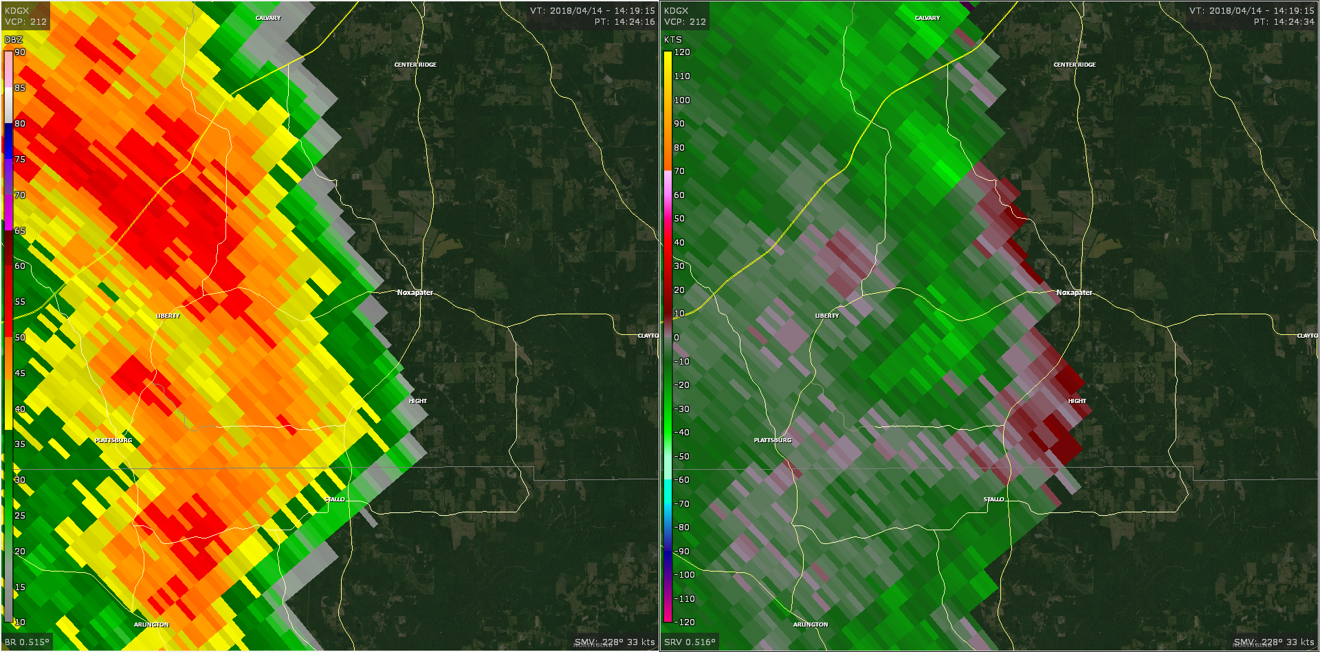
| Winston County 3 SW Noxapater |
9:23 AM - 9:25 AM |
EF-1 Tornado 105 mph |
none | 0.8 miles | 150 yards |
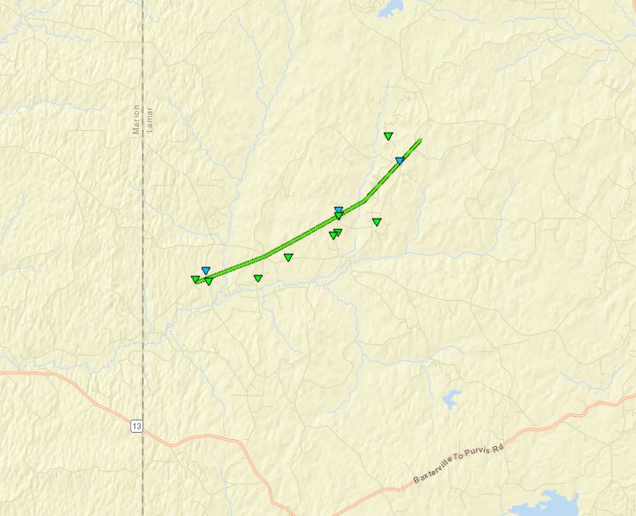
| Lamar County 13 ESE Columbia to 9 WNW Purvis |
10:07 AM - 10:15 AM |
EF-1 Tornado 95 mph |
none | 6.19 miles | 200 yards |
| Oktibbeha County 8 WNW Crawford to 7 SW Artesia |
10:08 AM - 10:10 AM |
EF-0 Tornado 85 mph |
none | 2.18 miles | 200 yards |
| Lauderdale County 2 SSW Meridian to 2 ENE Meridian |
10:43 AM - 10:53 AM |
EF-2 Tornado 115 mph |
2 injuries | 8.55 miles | 780 yards |
| Lowndes County 2 WNW Columbus to 2 NW Columbus |
10:44 AM - 10:45 AM |
Straight-line Wind 65 mph |
none | 1.3 miles | 600 yards |
Click on map above to see entire damage point notation and damage pictures at select points.
|
Track Summary This weak tornado began along Venable Road near Old River Road causing mostly minor tree damage. It continued northeast crossing I-20 at the Bouef River, snapping several large tree branches at the Bouef River Country Club. The tornado lifted as it crossed US 80 just west of Rayville, again snapping several large tree branches along Lewis Road and Insurance Road. |
|
Radar Imagery
These images from the University of Louisiana Monroe Doppler radar show the storm at 9:00 pm as the tornado began. The image on the left shows 1.8° base reflectivity data, and the image on the right shows 1.8° storm relative velocity data. Click on the thumbnail below for a higher resolution image.
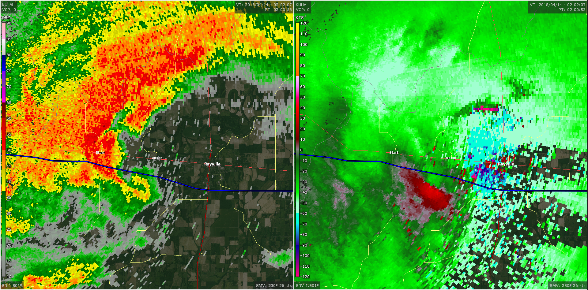
Morehouse/West Carroll Parish/Boeuf River EF-1 Tornado
Click on map above to see entire damage point notation and damage pictures at select points.
|
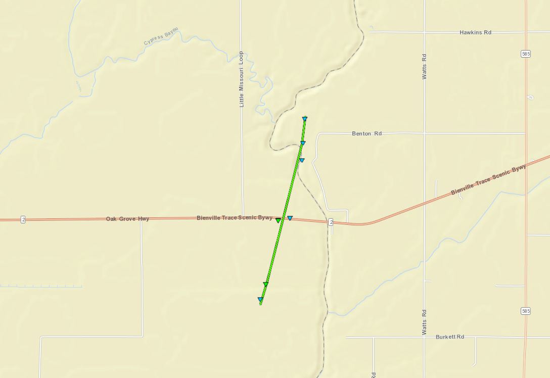
Track Summary This tornado began in open fields just west of the Bouef River and tracked northward across LA Highway 2, where it removed portions of the metal roof of an unoccupied building. The tornado continued northward along the Beouf River on the Morehouse and West Carroll Parish line just west of Benton Rd before ending shortly thereafter. Multiple trees were uprooted and trees and large tree branches were snapped along the path. |
|
Radar Imagery
These images from the University of Louisiana Monroe Doppler radar show the storm at 9:49 pm as the tornado moved north of LA Highway 2 along the Boeuf River. The image on the left shows 3° base reflectivity data, and the image on the right shows 1.8° storm relative velocity data. Click on the thumbnail below for a higher resolution image.
Southwest Ashley County EF-1 Tornado
Click on map above to see entire damage point notation and damage pictures at select points.
|
Track Summary This tornado originated in a flooded lowland over the Casey Jones Wildlife Management Area. The beginning point is estimated due to a lack of road access. The tornado tracked eastward across Ashley County roads 211, 703, 205, 3, 201, 202, and 2. Along its path, the tornado produced prolific tree damage, with many large uprooted and some snapped trees. A few homes were damaged by falling trees, some significantly, and a few also sustained shingle damage. The tornado ended in a wooded area north of Ashley Co Rd 2 and south of Ashley Co Rd 229. |
|
Radar Imagery
These images from the University of Louisiana Monroe Doppler radar show the storm at 2:44 am as the tornado moved across southwest Ashley County. The image on the left shows 3° base reflectivity data, and the image on the right shows 3° storm relative velocity data. Click on the thumbnail below for a higher resolution image.
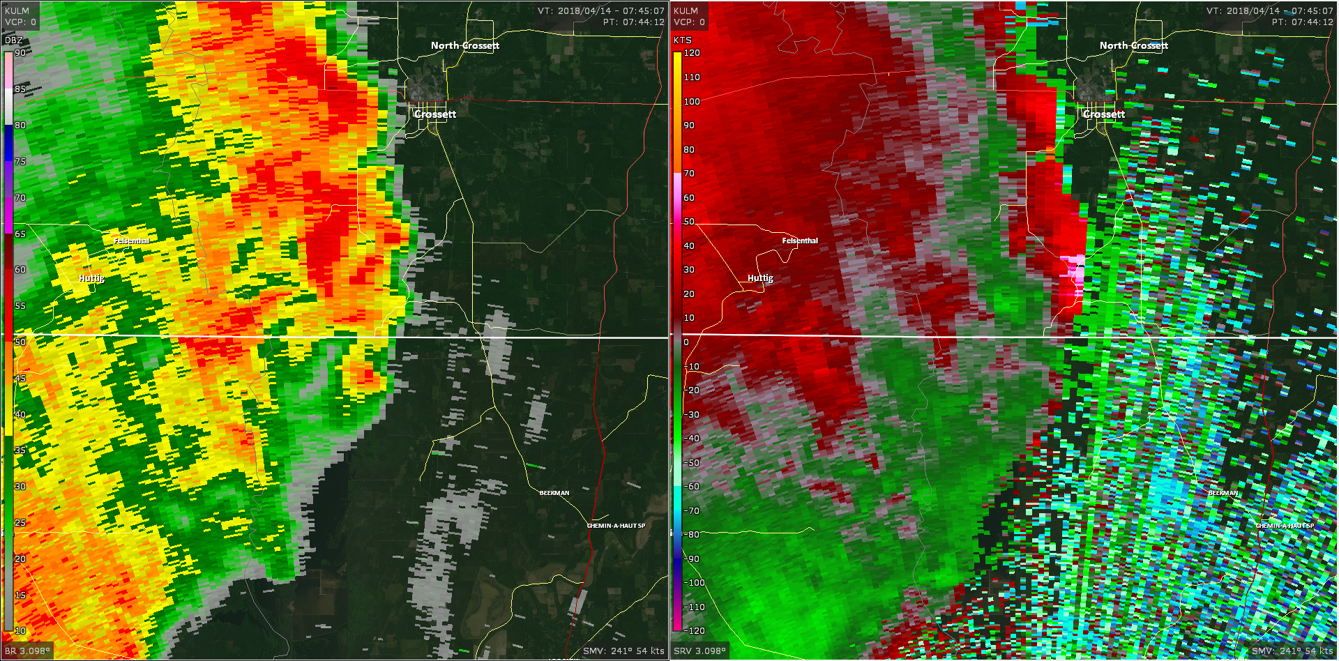
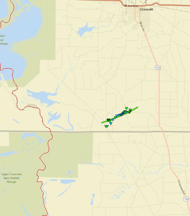
Central Ashley County/East Crossett EF-1 Tornado
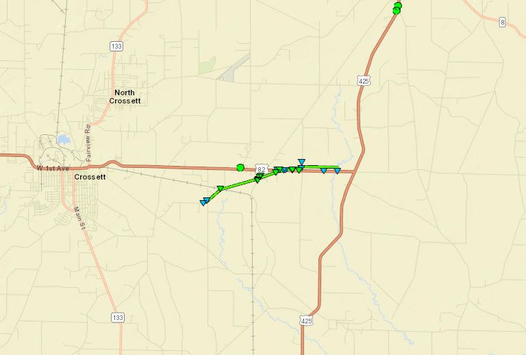
Click on map above to see entire damage point notation and damage pictures at select points.
|
Track Summary The tornado began near the intersection of Ashley Co Rd 7 E and Ashley Co Rd 7 S and tracked east northeastward. It reached peak intensity as it moved across Ashley Co Rd 23, where a significant number of trees were uprooted and a few were snapped. The tornado then began to roughly parallel US 82 from Ashley Co Rd 149 eastward to Ashley Co Rd 24. It lifted near Hanks Creek just north of US 82 before reaching US 425. There was also some structural damage to small sheds along the path. |
|
Radar Imagery
These images from the University of Louisiana Monroe Doppler radar show the storm at 2:54 am as the tornado moved along Highway 82. The image on the left shows 3° base reflectivity data, and the image on the right shows 1.8° storm relative velocity data. Click on the thumbnail below for a higher resolution image.
Click on map above to see entire damage point notation and damage pictures at select points.
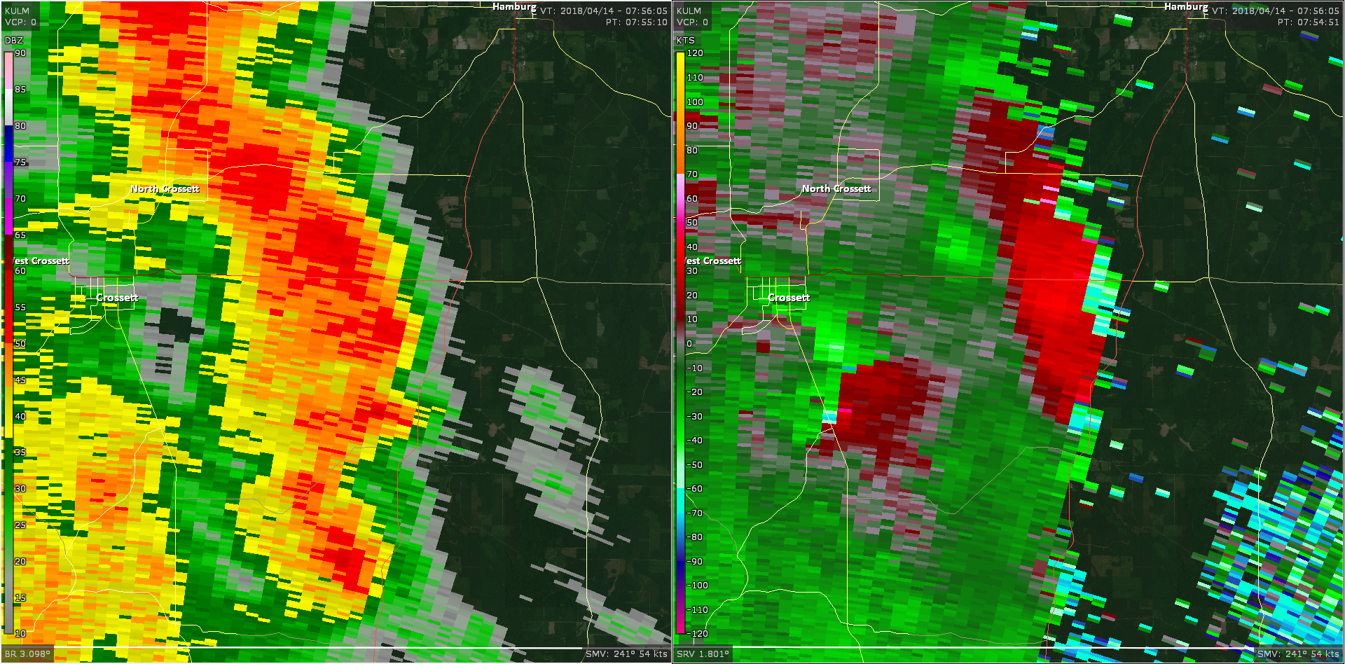
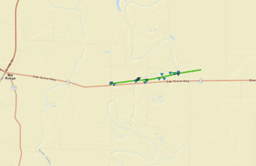
|
Track Summary This tornado began along Atwell Ln just north of LA Highway 2, blowing down a fence and blowing a small shed across the road. Large tree branches were also downed in this area. The tornado continued eastward parallel and just north of Highway 2, crossing Johnson School Rd and Rush Harrison Rd at Bayou Bonne Idee. On Johnson School Rd, a mobile home sustained roof and skirting damage and a small shed was destroyed. On Rush Harrison Rd, the front of a farm outbuilding was pushed in and there was substantial loss of roof panels. Larger trees were snapped and uprooted in this area as well. Additional trees were snapped or uprooted between Rush Harrison Rd and Highway 2, then the tornado crossed Merton Bowe Rd. Here, a couple of homes sustained roof damage and a shed was damaged. The tornado lifted over open fields north of Highway 2. |
|
Radar Imagery
These images from the Monroe, LA Doppler radar show the storm at 3:23 am as the tornado moved east of Mer Rouge. The image on the left shows 0.5° base reflectivity data, and the image on the right shows 0.5° storm relative velocity data. Click on the thumbnail below for a higher resolution image.
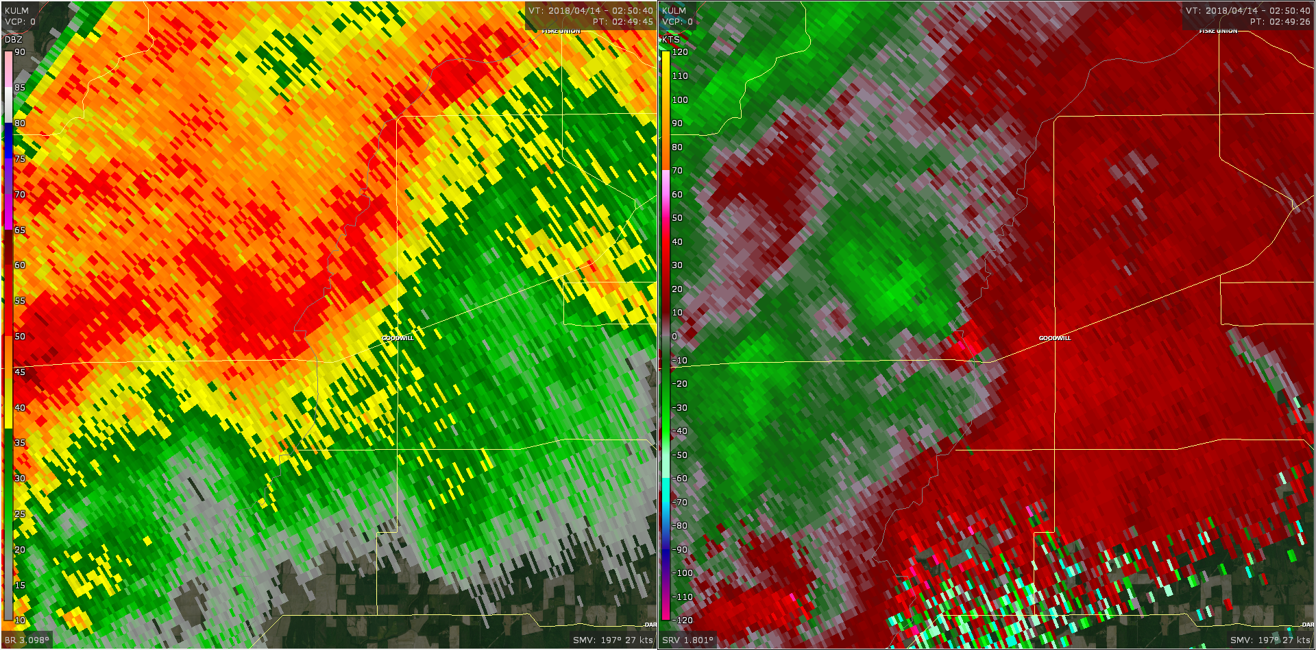
Ashley and Chicot County/Montrose EF-2 Tornado
Click on map above to see entire damage point notation and damage pictures at select points.
|
Track Summary The tornado began along US 165 between Portland and Montrose, where a few older utility poles were damaged and moved northwest across open fields, damaging additional utility poles along Ashley Co Rd 54. The tornado crossed US 82 near the Ashley/Chicot Co line. At this location, the top of a silo was removed and the structure was bent, two homes sustained exterior damage with one losing a large amount of roofing material, a travel trailer was destroyed, and a couple business sustained relatively minor structural damage. The tornado reached its peak intensity near this location, where two sets of wooden transmission poles were snapped. There was also considerable tree damage in the area. The tornado continued across Shelton Turner Rd, where a home and mobile home sustained damage. The tornado crossed AR Highway 293, Slaughter Rd, Beavers Rd, and Lingo Rd before lifting in west central Chicot County. |
|
Radar Imagery
These images from the Brandon, MS Doppler radar show the storm at 3:30 am as the tornado moved across western Chicot County. The image on the left shows 0.5° base reflectivity data, and the image on the right shows 0.5° storm relative velocity data. Click on the thumbnail below for a higher resolution image.
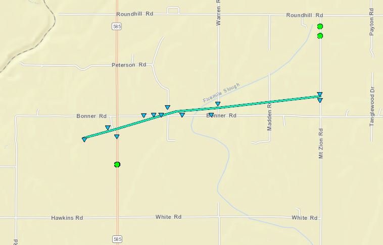
West Carroll Parish EF-0 Tornado #2
Click on map above to see entire damage point notation and damage pictures at select points.
|
Track Summary The tornado began west of LA Highway 585 south of Bonner Rd, where the roof of a barn was damaged and multiple trees were damaged. It continued eastward, roughly paralleling Bonner Rd and reached its peak intensity near the Bonner Rd and Peterson Rd intersection, where it destroyed a storage shed and scattered pieces of it over 1/3 mile downwind to Warren Rd. Another small storage shed was turned on its side and leaned against a mobile home at this location. The tornado then lifted along Mt Zion Rd just north of Bonner Rd. |
|
Radar Imagery
These images from the Monroe, LA Doppler radar show the storm at 3:35 am as the tornado moved across Warren Rd. The image on the left shows 0.5° base reflectivity data, and the image on the right shows 0.5° storm relative velocity data. Click on the thumbnail below for a higher resolution image.
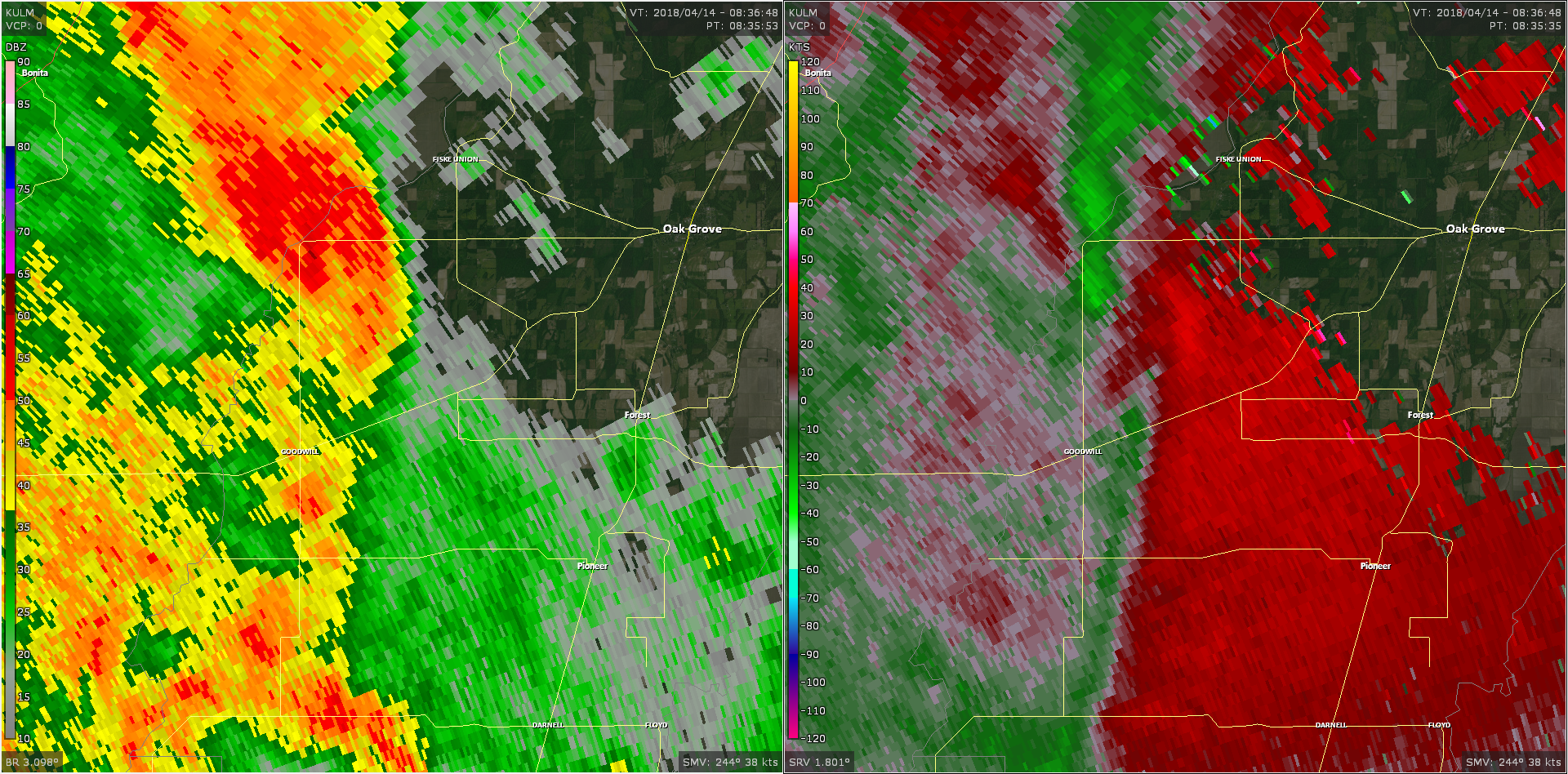
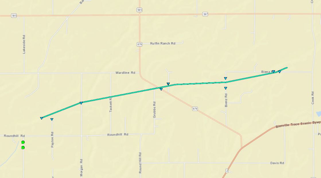
West Carroll Parish EF-0 Tornado #3
Click on map above to see entire damage point notation and damage pictures at select points.
|
Track Summary The tornado began north of Roundhill Rd, snapping and uprooting multiple trees. It continued eastward across Morgan Rd and Tackett Rd, damaging additional trees. It then crossed LA Highway 878 at the intersection with Grubbs Rd and Walters Rd, where a mobile home sustained roof damage. It then crossed Bienz Rd twice, lifting in a wooded area just north of the road. |
|
Radar Imagery
These images from the Monroe, LA Doppler radar show the storm at 3:38 am as the tornado moved across LA Highway 878. The image on the left shows 0.5° base reflectivity data, and the image on the right shows 0.5° storm relative velocity data. Click on the thumbnail below for a higher resolution image.
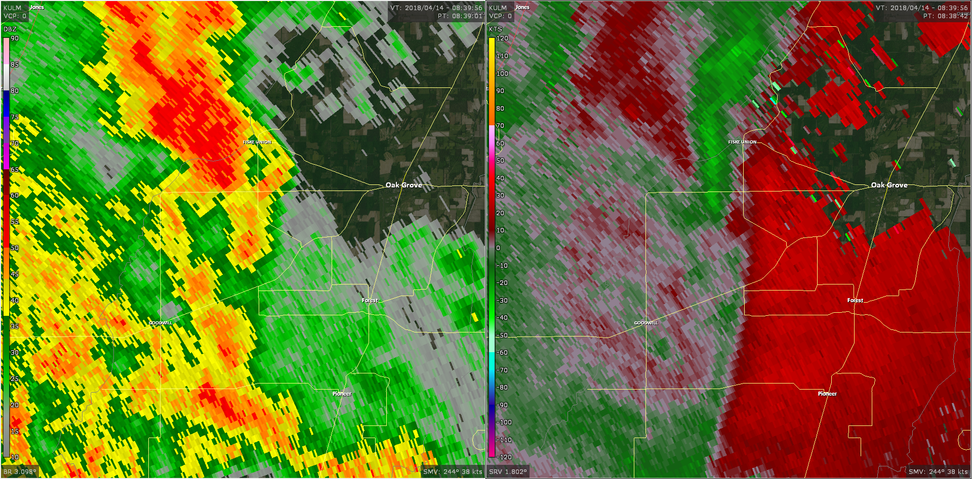
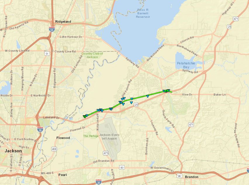
Rankin County/Flowood EF-1 Tornado
Click on map above to see entire damage point notation and damage pictures at select points.
|
Track Summary This tornado began near Jackson Preparatory School along Lakeland Drive and subsequently tracked east-northeast just north of the Lakeland Drive on its roughly 6 mile path length through west-central and into central Rankin County. Most of the damage was limited to trees with the most significant tree damage involving snapped and uprooted hardwood trees, yielding a low end EF-1 designation. There was scattered minor structural damage, mainly to roofs, as large limbs and trees fell upon residences. A few businesses also sustained minor structural damage due directly to winds near the intersection of Grants Ferry Road and Lakeland Drive. Along a portion of the tornado`s path through Flowood and Millcreek communities the track showed evidence of skipping and producing very limited damage. A driver on Lakeland Drive captured video of the tornado at the intersection with Vine Drive shortly before it lifted. |
|
Radar Imagery
These images from the Brandon, MS Doppler radar show the storm at 7:52 am as the tornado moved along Lakeland Drive in Flowood. The image on the left shows 0.5° base reflectivity data, and the image on the right shows 0.5° storm relative velocity data. Click on the thumbnail below for a higher resolution image.
Southern Winston County EF-1 Tornado
Click on map above to see entire damage point notation and damage pictures at select points.
|
Track Summary The tornado began southwest of Roberts Rd and traveled northeast. Along its path, some tin was ripped off of a large shed and several trees were snapped or uprooted. As the tornado crossed Roberts Rd, it ripped off part of the roof of a home. Several more large trees were uprooted or snapped in this area. The tornado continued northeast into a wooded area where the end point had to be estimated. |
|
Radar Imagery
These images from the Brandon, MS Doppler radar show the storm at 9:24 am as the tornado moved through southern Winston County. The image on the left shows 0.5° base reflectivity data, and the image on the right shows 0.5° storm relative velocity data. Click on the thumbnail below for a higher resolution image.
Click on map above to see entire damage point notation and damage pictures at select points.
|
Track Summary The tornado began near Johnson Road and Luther Saucier Road, snapping a few softwood trees and uprooting some hardwood trees. It then continued northeast, causing tree damage across Caney Church Road and Purvis to Columbia Road. It then crossed near the south and east side of Big Bay Lake, once again causing sporadic tree damage. The tornado lifted near Purvis Oloh Road. |
|
Radar Imagery
These images from the Brandon, MS Doppler radar show the storm at 10:10 am as the tornado moved through western Lamar County. The image on the left shows 0.5° base reflectivity data, and the image on the right shows 0.5° storm relative velocity data. Click on the thumbnail below for a higher resolution image.

Click on map above to see entire damage point notation and damage pictures at select points.
|
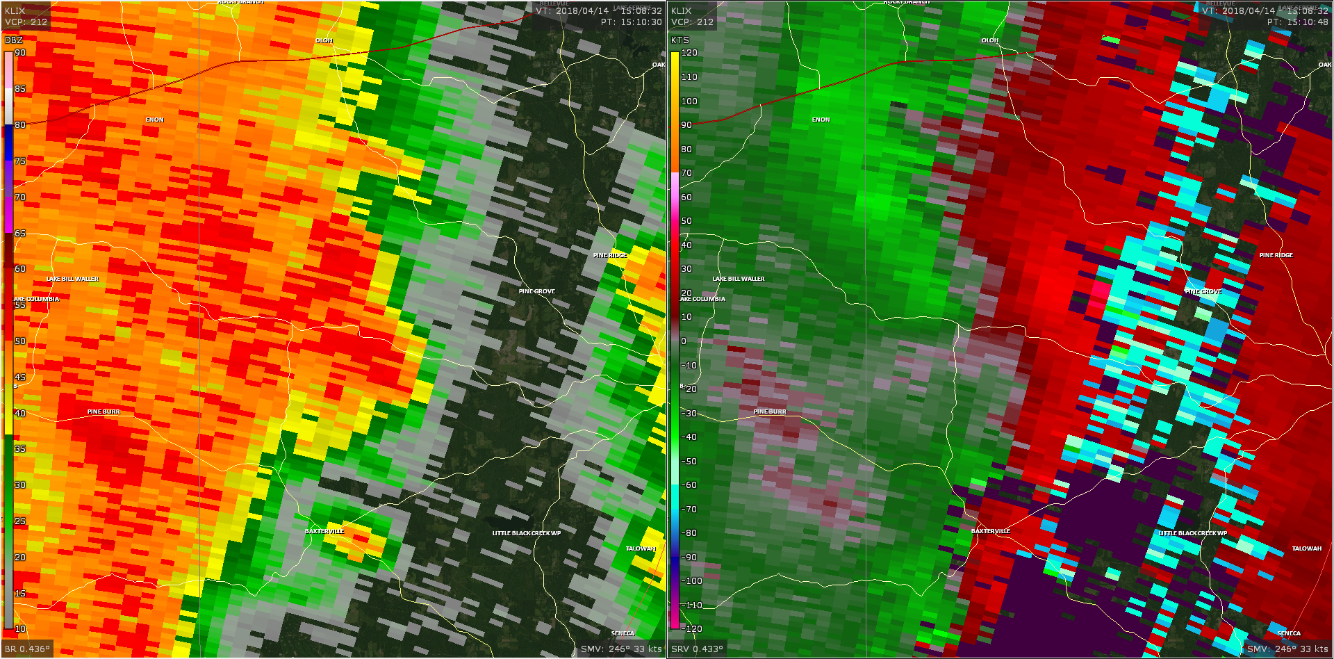
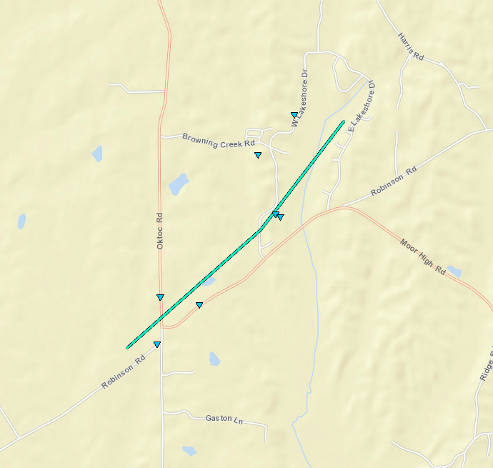
Track Summary This tornado began near Robinson Road and Oktoc Road. It continued to the northeast, mainly uprooting trees. It then crossed into the Browning Creek subdivision where it did damage to a metal awning at a marina and tossed some boats into the water. It also downed a couple of trees, with one falling onto a house. The tornado lifted shortly after moving through this area, near Lakeshore Drive. |
|
Radar Imagery
These images from the Brandon, MS Doppler radar show the storm at 10:09 am as the tornado moved into the Browning Creek subdivision. The image on the left shows 0.5° base reflectivity data, and the image on the right shows 0.5° storm relative velocity data. Click on the thumbnail below for a higher resolution image.

Click on map above to see entire damage point notation and damage pictures at select points.
|
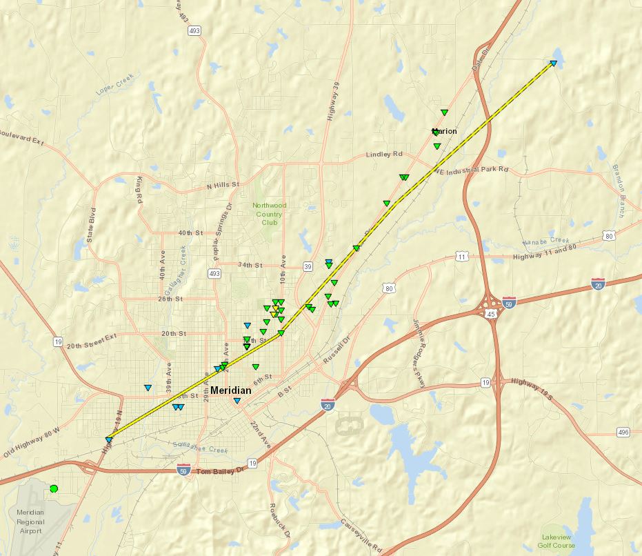
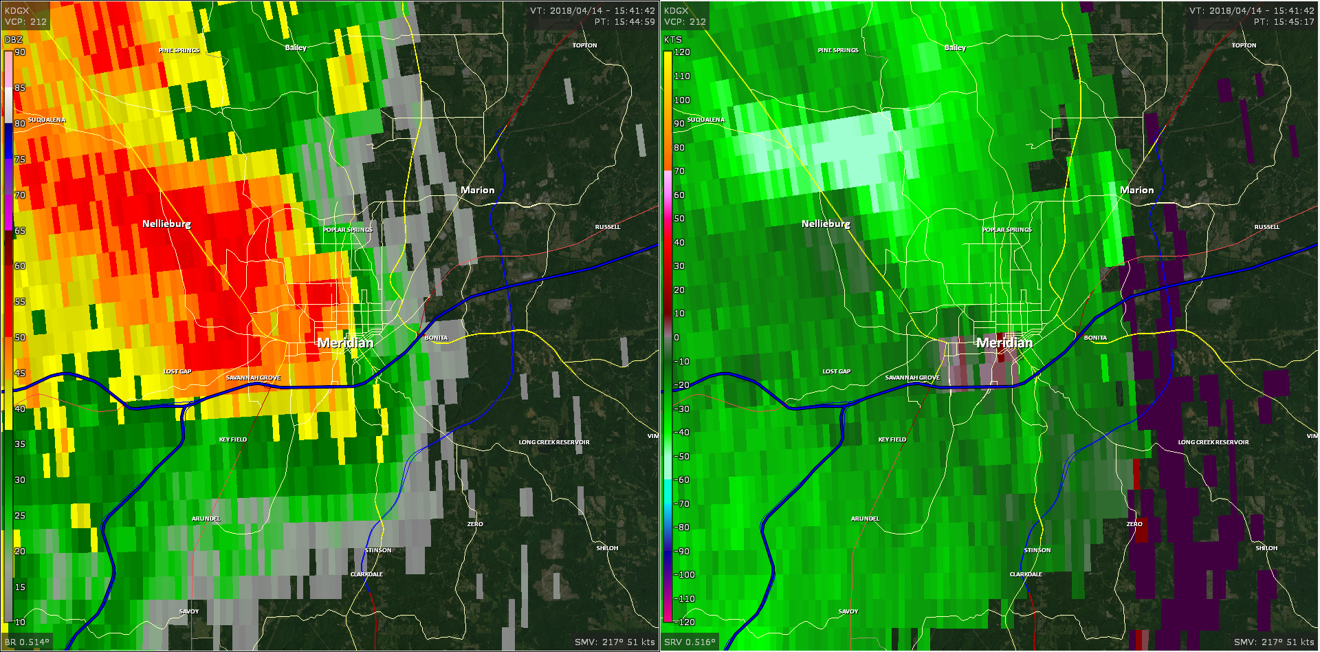
Track Summary This tornado developed just to the north of I-20 along Highway 19 N. It crossed through downtown Meridian, causing tree damage to much of the area. It caused structural damage to a few buildings along 14th Street, including roof and facade damage. The tornado reached its strongest intensity of EF2 strength as it neared 23rd Street. Here it snapped a couple of power poles, along with multiple hardwood and softwood trees. In addition, it tore the roof off of an apartment building and a portion of a building at Magnolia Middle School. Video evidence also indicated the tornado tore the roof off of a home near Grandview Avenue along with the loss of some exterior walls. The tornado continued to track northeast and generally followed Highway 45. Damage mainly consisted of trees being snapped or uprooted. Some of these trees fell onto homes. The tornado lifted near Willowlake Road. |
|
Radar Imagery
These images from the Brandon, MS Doppler radar show the storm at 10:44 am as the tornado moved through downtown Meridian. The image on the left shows 0.5° base reflectivity data, and the image on the right shows 0.5° storm relative velocity data. Click on the thumbnail below for a higher resolution image.
Columbus Straight-Line Wind Damage
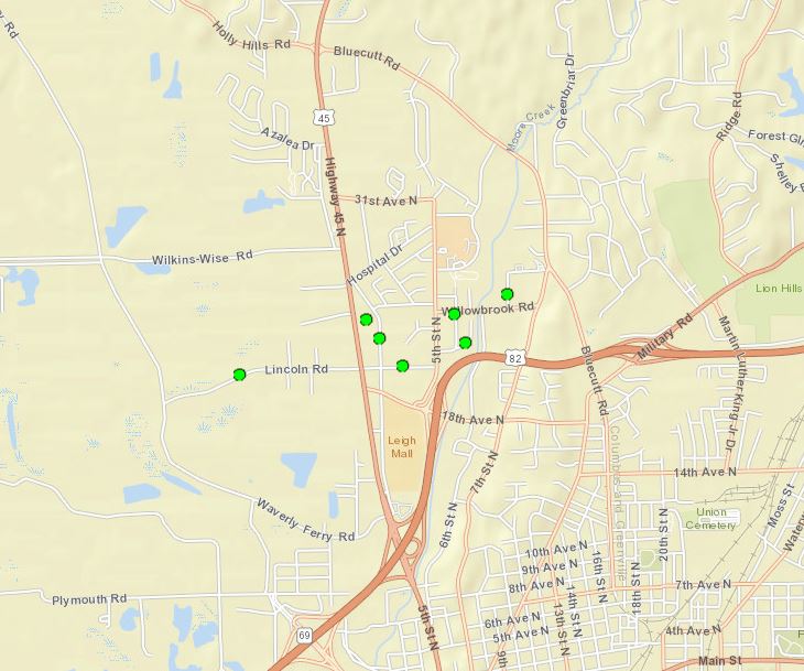

Click on map above to see entire damage point notation and damage pictures at select points.
|
Track Summary Several trees were snapped or uprooted across northern portions of the city of Columbus in a corridor extending from along Lincoln Road, across US Highway 82 to along Willowbrook Road just north of US Highway 82. Some homes and other buildings were damaged by fallen trees, and some businesses sustained minor damage, particularly to signs. The NWS survey team was unable to find sufficient conclusive evidence that this damage was the result of a tornado. |
|
Radar Imagery
These images from the Columbus, MS Doppler radar show the storm at 10:44 am as the storm moved through north Columbus. The image on the left shows 0.5° base reflectivity data, and the image on the right shows 0.5° storm relative velocity data. Click on the thumbnail below for a higher resolution image.


 Follow us on YouTube