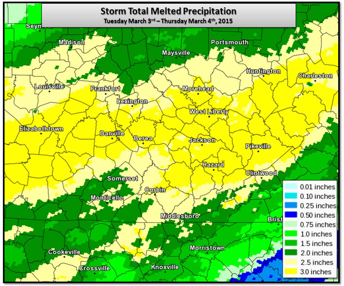
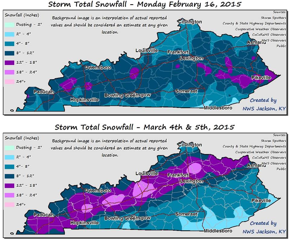
Another major late winter storm affected the state of Kentucky from late in the day on Tuesday March 3rd through the morning of Thursday March 5th, 2015. Rain overspread east Kentucky from late Tuesday March 3rd into the day of Wednesday March 4th, falling heavily at times. The rain then changed to sleet, some freezing rain and then snow from north to south Wednesday night into early Thursday morning March 5th and the snow fell heavily before diminishing late Thursday morning.
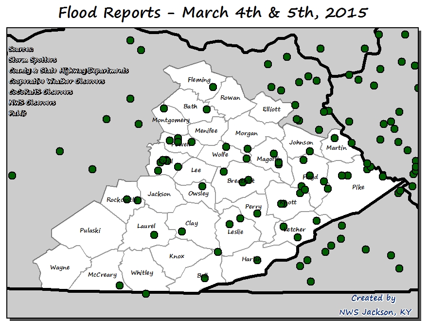
Heavy Rainfall & Flooding
The rain, coupled with a melting high elevation snow pack containing considerable water content, caused extensive runoff and produced widespread flooding of small creeks and streams and poor draining areas during the day on Wednesday. Some of the hardest hit areas on Wednesday were in Harlan and Bell Counties, where runoff quickly pushed the creeks and streams there over their banks.
River Flooding
The flooding then progressed into our rivers resulting in some of the worst river flooding in over a decade. In fact, on the Big Sandy, several locations experienced the highest water since 1984. The most noteworthy crest occured on the Cumberland River at Pineville, which based on preliminary information recorded the 3rd highest crest on record.
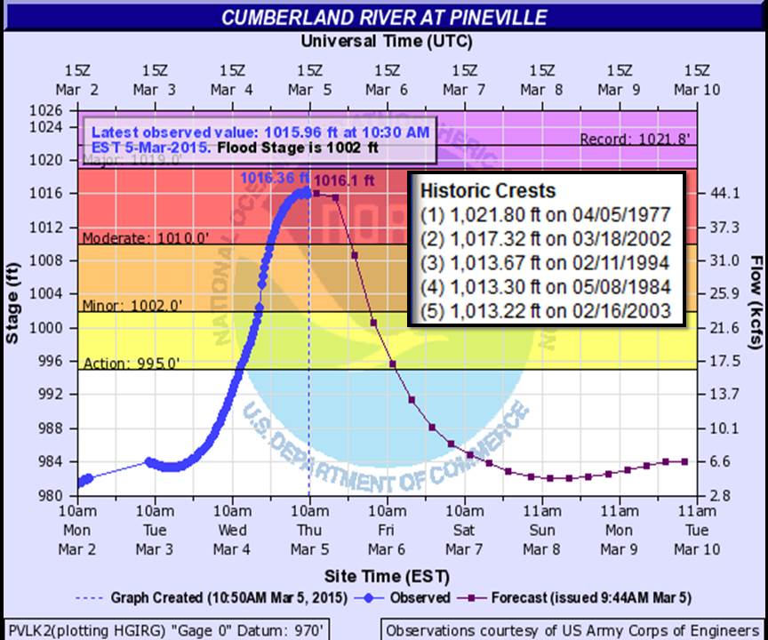
Some other noteworthy preliminary crests include:
Levisa Fork
Red River
Cumberland River
Kentucky River
Winter Storm
As area rivers where rising, the precipitation changed to sleet and then snow Wednesday night. An especially heavy band of snow set up from western Kentucky northeastward through central Kentucky into northeast Kentucky. By midday Thursday, over a foot of snow had fallen in this band mainly along and north of I-64 in east Kentucky. The snowfall amounts dropped significantly to the south with generally 2 to 4" having fallen near the Tennessee border.
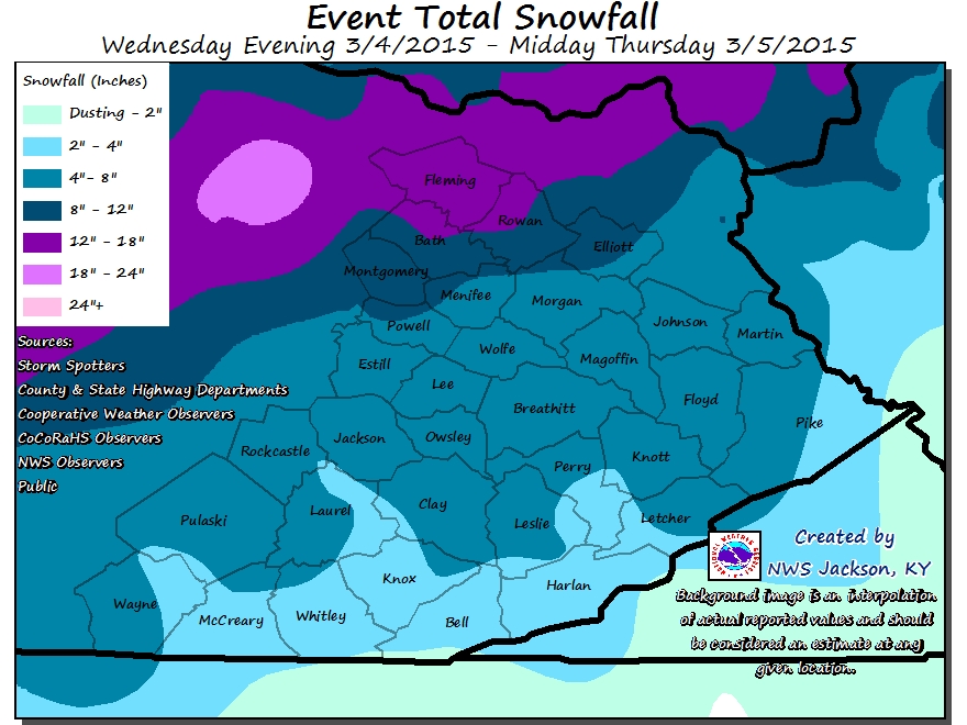
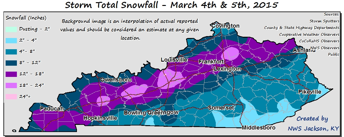
Below are some of the most significant snowfall reports received in the NWS Jackson, KY forecast area...
...BATH COUNTY...
OWINGSVILLE                  12.0 IN   1045 AM 03/05

...ELLIOTT COUNTY...
SANDY HOOK                   9.0 IN    1045 AM 03/05
GIMLET                       9.0 IN    0833 AM 03/05

...ESTILL COUNTY...
CRESSY                       7.3 IN    0833 AM 03/05

...FLEMING COUNTY...
FLEMINGSBURG                 15.8 IN   0125 PM 03/05
2 NW MOUNT CARMEL            14.0 IN   0300 PM 03/05

...MENIFEE COUNTY...
FRENCHBURG                   8.0 IN    1045 AM 03/05

...MONTGOMERY COUNTY...
JEFFERSONVILLE               11.5 IN   1152 AM 03/05
MOUNT STERLING               9.0 IN    1045 AM 03/05

...POWELL COUNTY...
4 ESE STANTON                7.0 IN    1113 AM 03/05
STANTON                      6.0 IN    0630 AM 03/05

...ROWAN COUNTY...
HILDA                        13.3 IN   0220 PM 03/05
MOREHEAD                     12.0 IN   0850 AM 03/05

OBSERVATIONS ARE COLLECTED FROM A VARIETY OF SOURCES WITH VARYING
EQUIPMENT AND EXPOSURE. NOT ALL DATA LISTED ARE CONSIDERED OFFICIAL.
For most of the state, this was the second major snow storm in three weeks...
Record Breaking Cold
Following the snow, bitter cold temperatures invaded the state. A new all time state record for March with respect to low temperature was established Friday morning March 6th at Hillsboro, which is a National Weather Service cooperative station located in Fleming County, where the temperature fell to -16F. The previous record low temperature for March for the state of Kentucky was -14F at Bonnieville on March 6th, 1960.
Below is a sampling of the coldest observed temperatures in the NWS Jackson, KY forecast area for the morning of March 6th...
LOCATION TEMP TIME/DATE
HILLSBORO (COOP) -16 F 0800 AM 03/06
5 N MOUNT STERLING (COOP) -12 F 0700 AM 03/06
MONTICELLO APT -11 F 0656 AM 03/06
MOUNT STERLING APT -9 F 0715 AM 03/06
4 S OWINGSVILLE -9 F 0635 AM 03/06
CLOVER BOTTOM 1 WSW -8 F 0700 AM 03/06
4 NE MOREHEAD -7 F 0635 AM 03/06
SANDY HOOK 1 NE -7 F 0800 AM 03/06
4 W PAINTSVILLE -6 F 0635 AM 03/06
2 SW WEST LIBERTY -4 F 0605 AM 03/06
CRESSY (COOP) -4 F 0800 AM 03/06
BOONEVILLE 12SW -4 F 0800 AM 03/06
3 N FARMERS -3 F 0635 AM 03/06
5 S MCKEE -3 F 0630 AM 03/06
CAVE RUN LAKE (COOP) -2 F 0700 AM 03/06
MOUNT VERNON (COOP) -1 F 0800 AM 03/06
WELLINGTON -1 F 0700 AM 03/06
3 SE BARBOURVILLE -1 F 0720 AM 03/06
13 S PIKEVILLE -1 F 0635 AM 03/06
OBSERVATIONS ARE COLLECTED FROM A VARIETY OF SOURCES WITH VARYING EQUIPMENT AND EXPOSURE. NOT ALL DATA LISTED ARE CONSIDERED OFFICIAL.


 Follow us on YouTube