National Weather Service United States Department of Commerce
June 4, 2007 Severe Weather
Northern Vermilion Parish Flooding & Historic Lake Charles hailstorm

by Sam Shamburger, Journeyman Forecaster

Monday, June 4th 2007, had conditions again appear favorable for severe weather to develop across the region, despite the widespread severe weather that had affected much of Southeast Texas and Southwest Louisiana the previous day.  One mid-level jet streak moved eastward across southern Louisiana during the morning hours, while another stronger mid-level jet streak, unusual for June, moved southeastward from Texas into Louisiana later in the day.  A very warm and unstable airmass was in place all across the region, with temperatures expected to warm into the upper 80s and lower 90s with dewpoints in the 60s and 70s.  The complex of thunderstorms that had pushed across the area on Sunday, June 3rd, left an outflow boundary that stretched from around Woodville, Texas to Lake Charles, Louisiana and eastward to around New Iberia, Louisiana.  This boundary separated somewhat drier air to the north from more moist air to the south.

NORTHERN VERMILION PARISH FLOODING
Showers and thunderstorms began developing early in the morning across Acadiana south of Lafayette along the outflow boundary.  This boundary moved slowly northward into northern Vermilion Parish, southern Lafayette Parish, and northern Iberia Parish by early afternoon, before stalling between the cities of Kaplan and Maurice.  Showers and thunderstorms, some even reaching severe levels, continued to regenerate along this boundary near Gueydan and moved eastward throughout the afternoon, leading to torrential rainfall in a narrow corridor across northern Vermilion Parish.  By Monday evening, radar had estimated that 10 to 14 inches of rain had fallen about 2 miles southwest of Maurice.  This led to widespread flooding of homes in the area, some of which had reportedly never flooded before.  Many roadways in the area were also submerged, including major thoroughfares such as Highway 167.  Media reports indicate around 50 homes received flood damage.

6/4/07 Storm Total Rainfall
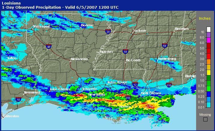
June 4th, 2007 Storm Total Rainfall for Louisiana
showing the small area of extreme rainfall in northern Vermilion Parish


LAKE CHARLES HAILSTORM
Further to the west, an isolated severe thunderstorm developed near Corrigan, Texas, along the outflow boundary left from the complex of thunderstorms that affected the region on June 3rd.  This storm moved southeastward along the boundary into Tyler County during the afternoon.  As it approached the Colmesneil and Woodward areas, large hail and damaging winds began to be reported.  Radar showed this storm to be an outflow-dominant multicell/occasional supercell thunderstorm, a type of severe thunderstorm which produces mainly damaging winds and large hail instead of tornadoes.  The storm continued southeastward at 35 to 40 mph across Jasper and Newton Counties, and continued to produce large hail and wind damage reports as it moved into Southwest Louisiana.  

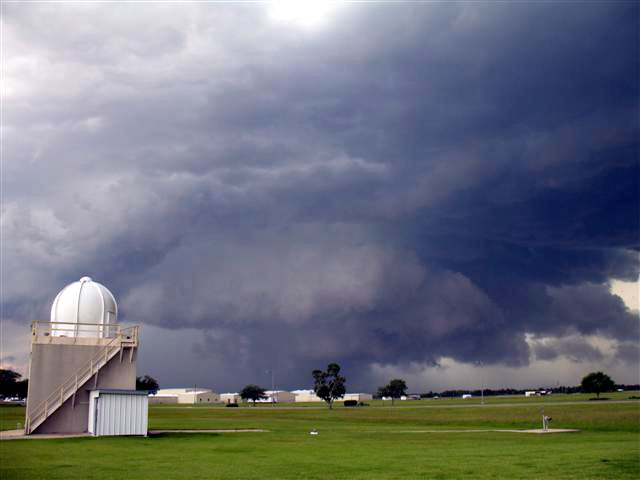
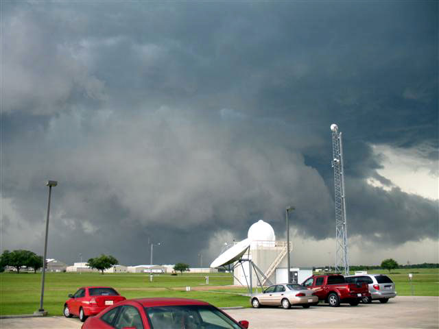
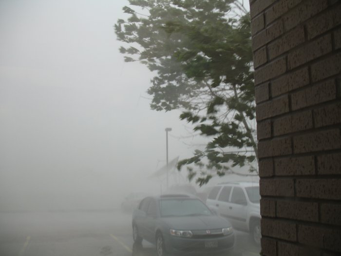
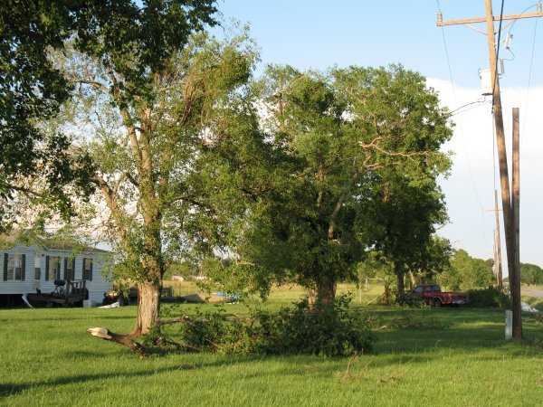
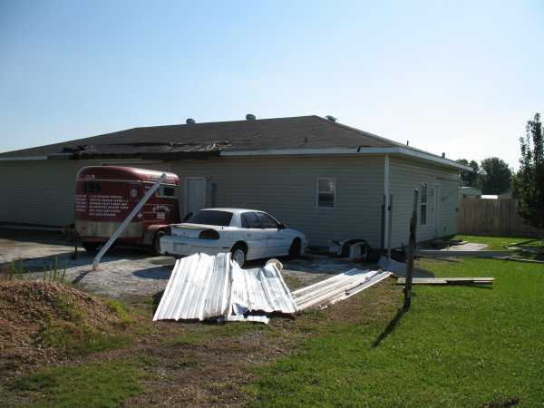
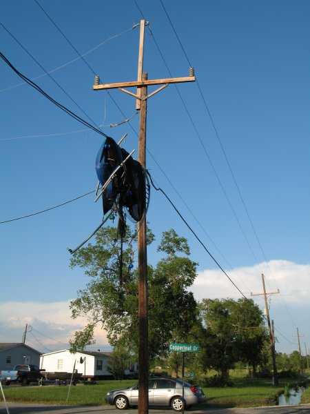
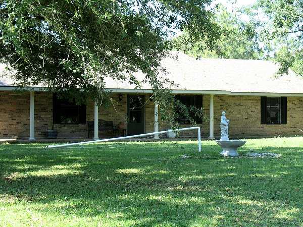
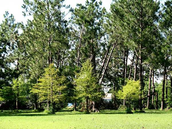
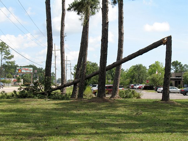
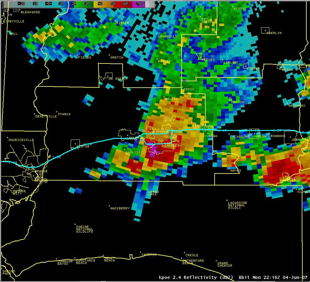
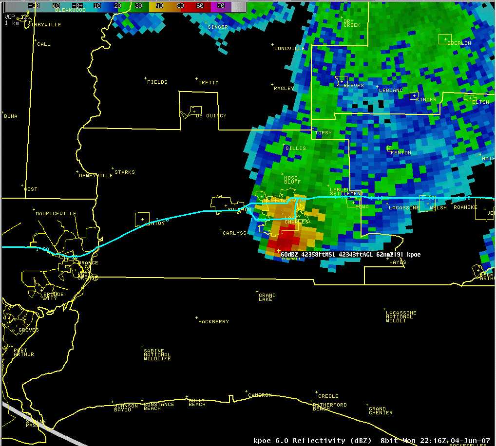
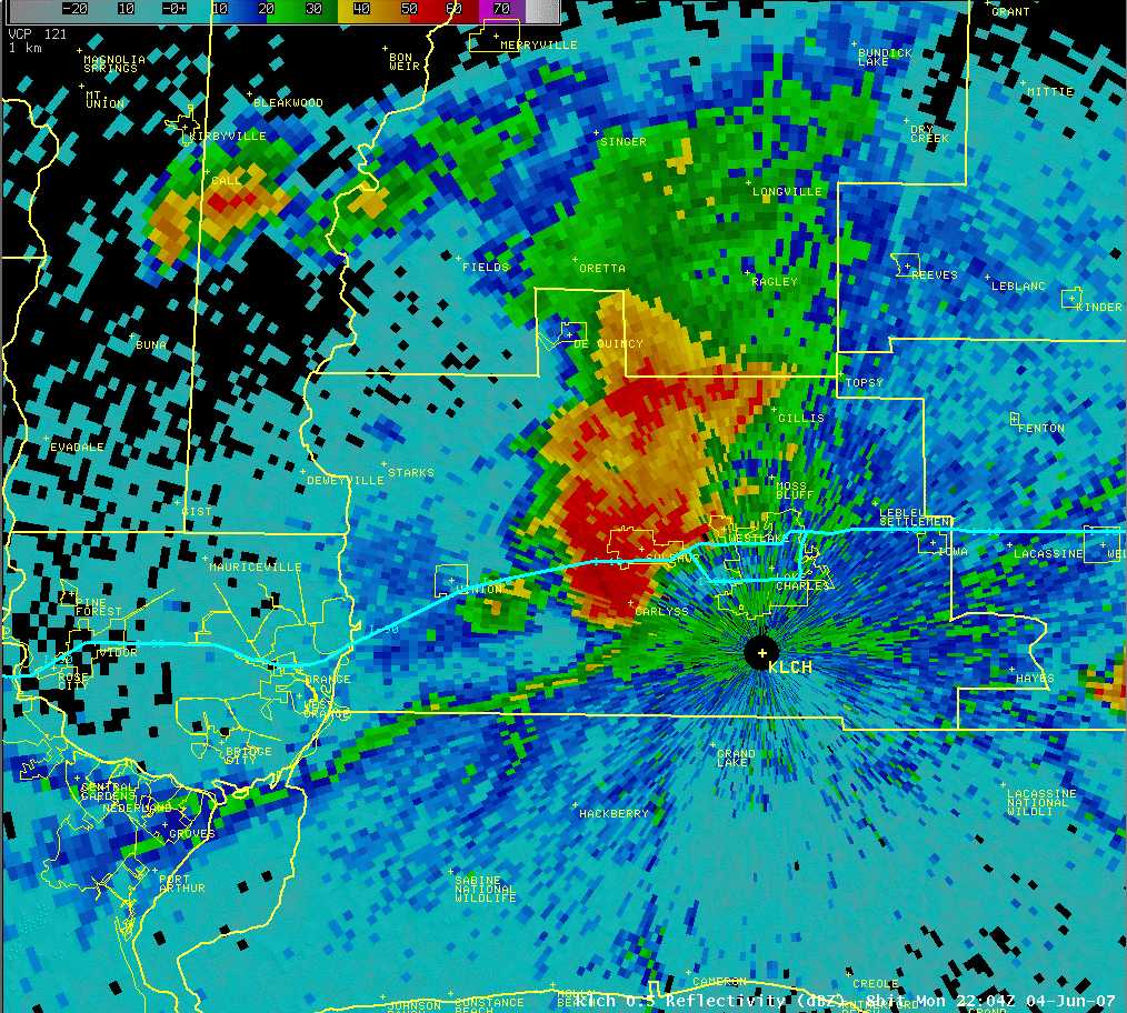
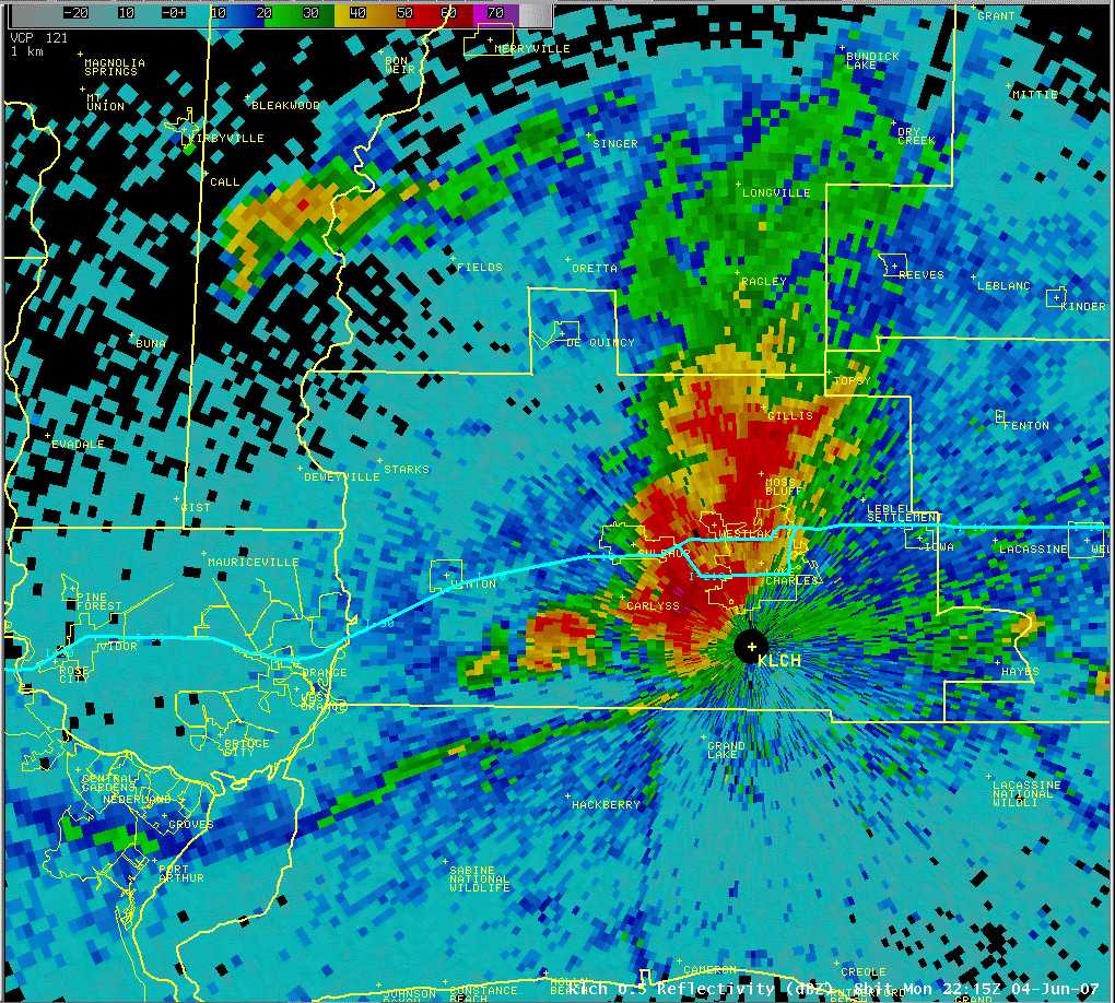
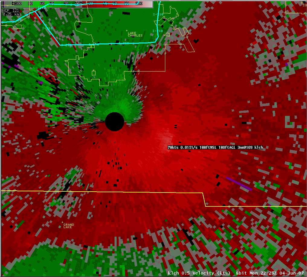
As the storm entered southwestern Beauregard and Calcasieu parishes, radar began showing a large area of 50 to 70 mph winds heading towards the Lake Charles metropolitan area.  The thunderstorm began intensifying even further as it reached the Carlyss area, with radar-indicated winds up to 80 mph and a strong likelihood of large hail.  As the storm moved into Lake Charles, numerous reports of high winds and hail up to golfball size covering the ground were received, mainly in southern Lake Charles south of the I-210 corridor.  When the storm reached the NWS Lake Charles office (located at the Lake Charles Regional Airport), several winds gusts over 55 mph were recorded, with the peak gust reaching 75 mph (equivalent to a Category 1 Hurricane).  The storm continued to intensify as it moved southeast of Lake Charles into southeastern Calcasieu Parish, with radar indicating winds up to 90 mph and a substantial area of large hail.  However, no reports of damage were received in this area.  The storm began to weaken as it moved into southern Jefferson Davis, northeastern Cameron, and western Vermilion parishes - due to the rain-cooled air from the numerous thunderstorms across Acadiana - and finally dissipated along the coast after its 150 mile journey. 

A quick look at historical records shows that there have been 31 reports of golfball size (1.75" diameter) or larger hail somewhere in Calcasieu Parish since 1960, with May the peak month for 1.75" or larger hail and June a close second.  However, there have been no recorded major damaging hailstorms in the parish.  The June 4th event severely damaged 11 homes (mainly due to falling trees), and there were widespread reports of broken windows, trees blown onto homes, and vehicles damaged.  Damage amounts in dollars from this storm are conservatively estimated at around $500,000.  All of this data indicates the June 4th event was one of the most damaging hailstorms in Lake Charles' history - a truly historic event!

LAKE CHARLES HAILSTORM - PHOTOS
south lake charles hail 01
south lake charles hail 02
south lake charles hail 03
Hail completely covers the ground in south Lake Charles
photo by Stephen Carboni, Forecaster
High winds create hail drifts in south Lake Charles
photo by Stephen Carboni, Forecaster
Just one of the many large hailstones
photo by Stephen Carboni, Forecaster
view from nws office 01
view from nws office 02
view from nws office 03
Spectacular severe thunderstorm approaches the Lake Charles Regional Airport
photo by Sam Shamburger, Forecaster
Severe thunderstorm approaches NWS Lake Charles office
photo by Sam Shamburger, Forecaster
75 mph winds and quarter-size hail blast the NWS office
photo by Sam Shamburger, Forecaster
After the storm Tank Farm Road Wind Damage 01
Tank Farm Road Wind Damage 02
Visually impressive mammatus clouds were seen as the severe thunderstorm exited Lake Charles
photo by Sam Shamburger, Forecaster
Numerous large tree limbs were blown down on Tank Farm Road
photo by Sam Shamburger, Forecaster
Siding and roof damage was done to this building on Tank Farm Road
photo by Sam Shamburger, Forecaster
Tank Farm Road Damage 03 Tank Farm Road Damage 04 trampoline in power lines
Siding and fences were blown down on Tank Farm Road
photo by Sam Shamburger, Forecaster
Numerous large tree limbs were blown down on Tank Farm Road
photo by Sam Shamburger, Forecaster
Trampoline blown onto and wrapped around power lines
photo by Sam Shamburger, Forecaster
Southeast Lake Charles Damage 01 Southeast Lake Charles Wind Damage 02
Southeast Lake Charles Wind Damage 02
Siding was blown off this home in southeast Lake Charles
photo by Sam Shamburger, Forecaster
A flag pole was blown down in southeast Lake Charles
photo by Sam Shamburger, Forecaster
Numerous trees were blown down in southeast Lake Charles
photo by Sam Shamburger, Forecaster
Southeast Lake Charles Damage 04 Tree blown down on Nelson Road in Lake Charles
Rental Car Trailer Flipped Over at Lake Charles Regional Airport
Numerous large tree limbs were blown down in southeast Lake Charles
photo by Sam Shamburger, Forecaster
Numerous trees were blown down in south Lake Charles, such as this one on Nelson Road
photo by Sam Shamburger, Forecaster
A rental car trailer was flipped over at the Lake Charles Regional Airport
photo by Sam Shamburger, Forecaster
 
LAKE CHARLES HAILSTORM - RADAR IMAGERY
classic hail spike
Fort Polk Radar reflectivity image at 516pm showed a classic hail spike signature over Lake Charles.  A hail spike is a false radar signature caused by the radar beam bouncing off large hailstones aloft.
43000 foot reflectivity core at 2216
Fort Polk Radar reflectivity image at 516pm indicated a 60dbz core of reflectivity up to 43000 feet above southern Lake Charles.  This is highly suggestive of a severe thunderstorm containing large hail.
reflectivity image at 2204
Lake Charles Radar reflectivity image at 504pm showing the severe thunderstorm moving into Sulphur & Carlyss
close up velocity image at 2204 Lake Charles Radar velocity image at 504pm showing winds up to 61 knots (70 mph) moving into Sulphur & Carlyss
reflectivity image at 2215
Lake Charles Radar reflectivity image at 515pm showing the severe thunderstorm just west of the radar & NWS office
close up velocity image at 2215 Lake Charles Radar velocity image at 515pm showing winds up to 68 knots (78 mph) moving across south Lake Charles towards the regional airport and NWS office
reflectivity image at 2225
Lake Charles Radar reflectivity image at 525pm showing the severe storm moving away from the NWS office.  Note the hook echo just east of the radar.
close up velocity image at 2225 Lake Charles Radar velocity image at 525pm showing even stronger winds up to 78 knots (90 mph) moving across southeastern Calcasieu Parish
reflectivity image at 2231
Lake Charles Radar reflectivity image at 531pm showing the severe thunderstorm moving away from the NWS office.  Note the hook echo southeast of the radar.
close up velocity image at 2231 Lake Charles Radar velocity image at 531pm showing winds up to 72 knots (83 mph) moving across southeastern Calcasieu Parish
 
SELECTED HAILSTORMS IN LAKE CHARLES AREA SINCE 1995
LOCATION
DATE
HAIL SIZE
DAMAGE IN $
Lake Charles/Carlyss LA 6/04/2007 1.75" (GOLFBALL) estimated $500,000
Sulphur LA 5/29/2005 1.75" (GOLFBALL) none reported
Sulphur LA 6/03/2003 1.75" (GOLFBALL) none reported
Gillis LA 6/03/2003 1.75" (GOLFBALL) none reported
Lake Charles LA 7/24/2002 1.75" (GOLFBALL) none reported
Westlake LA 1/02/1999 0.75" (PENNY) $50,000
Sulphur LA 3/06/1995 1.75" (GOLFBALL) none reported
 
SELECTED PEAK WIND GUSTS IN LAKE CHARLES AREA SINCE 1950
LOCATION
DATE
PEAK WIND GUST
NOTES
NWS Lake Charles 6/04/2007 75 MPH Accompanied by Quarter-size Hail
Lake Charles Regional Airport 5/14/2007 66 MPH Localized downburst around airport area
NWS Lake Charles 9/24/2005 96 MPH Hurricane Rita
Lake Charles Regional Airport 11/16/1987 69 MPH F1 Tornado passed near the airport
NWS Lake Charles 8/05/1964 78 MPH Highest known wind gust during a thunderstorm
NWS Lake Charles 6/27/1957 97 MPH Hurricane Audrey
NWS Lake Charles 4/29/1953 75 MPH F0 Tornado passed near the office


ALL LOCAL STORM REPORTS FOR JUNE 4, 2007
PRELIMINARY LOCAL STORM REPORT...SUMMARY
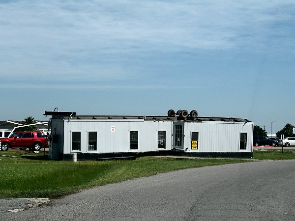
NATIONAL WEATHER SERVICE LAKE CHARLES LA
356 PM CDT TUE JUN 05 2007

..TIME...   ...EVENT...      ...CITY LOCATION...     ...LAT.LON...
..DATE...   ....MAG....      ..COUNTY LOCATION..ST.. ...SOURCE....
            ..REMARKS..

1200 PM     HAIL             AVERY ISLAND            29.90N 91.91W
06/04/2007  E0.25 INCH       IBERIA             LA   PUBLIC

1230 PM     TSTM WND DMG     4 SW ABBEVILLE          29.93N 92.17W
06/04/2007                   VERMILION          LA   LAW ENFORCEMENT

            TREE FELL ACROSS THE ROADWAY NEAR HWY 693 AND DETRAZ RD.

0305 PM     HAIL             COLMESNEIL              30.91N 94.42W
06/04/2007  E0.75 INCH       TYLER              TX   LAW ENFORCEMENT

            REPORTED BY TYLER COUNTY SHERIFFS OFFICE

0310 PM     HAIL             3 N WOODVILLE           30.82N 94.42W
06/04/2007  E1.00 INCH       TYLER              TX   LAW ENFORCEMENT

            REPORTED IN DOUCETTE BY TYLER COUNTY SHERIFF OFFICE

0335 PM     HAIL             MAURICE                 30.11N 92.12W
06/04/2007  M0.75 INCH       VERMILION          LA   LAW ENFORCEMENT

            REPORTED BY OFFICER AT YOUNGSVILLE PD WHO LIVES IN
            MAURICE.

0335 PM     TSTM WND DMG     1 W SPURGER             30.69N 94.19W
06/04/2007                   TYLER              TX   LAW ENFORCEMENT

            ENTERGY POWER STATION DAMAGED WITH NUMEROUS TREES AND
            POWER LINES BLOWN DOWN. POWER OUT IN SPURGER.

0336 PM     HAIL             SPURGER                 30.69N 94.18W
06/04/2007  E0.75 INCH       TYLER              TX   PUBLIC

0345 PM     TSTM WND DMG     1 W SPURGER             30.69N 94.19W
06/04/2007                   TYLER              TX   LAW ENFORCEMENT

            8 INCH DIAMETER TREE BLOWN DOWN ON FM 1013

0350 PM     TSTM WND DMG     FRED                    30.58N 94.18W
06/04/2007                   TYLER              TX   EMERGENCY MNGR

            POWER LINES BLOWN DOWN

0400 PM     TSTM WND DMG     BUNA                    30.44N 93.96W
06/04/2007                   JASPER             TX   LAW ENFORCEMENT

            A FEW TREES AND POWER LINES BLOWN DOWN AROUND BUNA. ALSO
            HAIL FELL BUT UNKNOWN SIZE.

0405 PM     TSTM WND DMG     CALL                    30.61N 93.87W
06/04/2007                   NEWTON             TX   UTILITY COMPANY

            POWER LINES BLOWN DOWN

0420 PM     FLASH FLOOD      MAURICE                 30.11N 92.12W
06/04/2007                   VERMILION          LA   BROADCAST MEDIA

            NUMEROUS ROADS UNDERWATER IN THE MAURICE AND INDIAN BAYOU
            AREAS INCLUDING HIGHWAY 167 AND HIGHWAY 699

0440 PM     TSTM WND DMG     4 WSW DEQUINCY          30.42N 93.50W
06/04/2007                   BEAUREGARD         LA   NWS EMPLOYEE

            NWS EMPLOYEE REPORTS TREES DOWN ALONG HIGHWAY 12

0500 PM     HAIL             SULPHUR                 30.23N 93.36W
06/04/2007  E0.75 INCH       CALCASIEU          LA   PUBLIC

            TREE BRANCHES BLOWN ACROSS I-10 WITH PENNY SIZE HAIL AT
            DEQUINCY EXIT IN SULPHUR

0505 PM     HAIL             3 NW CARLYSS            30.21N 93.41W
06/04/2007  E1.75 INCH       CALCASIEU          LA   EMERGENCY MNGR

            REPORTED BY EMERGENCY MANAGEMENT OFFICIAL

0510 PM     HAIL             CARLYSS                 30.18N 93.37W
06/04/2007  E0.75 INCH       CALCASIEU          LA   PUBLIC

            PENNY SIZE HAIL AND VERY HIGH WINDS REPORTED

0520 PM     HAIL             3 SSW LAKE CHARLES      30.17N 93.22W
06/04/2007  M1.00 INCH       CALCASIEU          LA   NWS EMPLOYEE

            QUARTER-SIZED HAIL AND ESTIMATED 45 TO 50 MPH WINDS IN
            SOUTH LAKE CHARLES NEAR INTERSECTION OF LAKE STREET AND
            SALE ROAD

0520 PM     HAIL             3 SW LAKE CHARLES       30.18N 93.24W
06/04/2007  E1.75 INCH       CALCASIEU          LA   EMERGENCY MNGR

            REPORTED AT NELSON ROAD AND MCNEESE ROAD INTERSECTION

0520 PM     TSTM WND DMG     6 SW LAKE CHARLES       30.15N 93.27W
06/04/2007                   CALCASIEU          LA   NWS EMPLOYEE

            NWS EMPLOYEE REPORTS GOLF BALL SIZE HAIL AND SIDING BLOWN
            OFF NEIGHBORS HOUSE

0520 PM     HAIL             3 SSW LAKE CHARLES      30.17N 93.22W
06/04/2007  M0.88 INCH       CALCASIEU          LA   NWS EMPLOYEE

            LAKE STREET AND MCNEESE ROAD

0520 PM     TSTM WND DMG     3 SW LAKE CHARLES       30.18N 93.24W
06/04/2007                   CALCASIEU          LA   NWS EMPLOYEE

            TREE BLOWN DOWN AT NELSON ROAD AND COUNTRY CLUB ROAD

0521 PM     HAIL             4 S LAKE CHARLES        30.15N 93.20W
06/04/2007  E1.75 INCH       CALCASIEU          LA   NWS EMPLOYEE

            ALL SKYLIGHTS BROKEN IN HOUSE

0521 PM     HAIL             4 S LAKE CHARLES        30.15N 93.20W
06/04/2007  E1.75 INCH       CALCASIEU          LA   NWS EMPLOYEE

            PENNY TO GOLFBALL SIZE HAIL COMPLETELY COVERED THE GROUND
            AT LAKE STREET AND CADE BOULEVARD. TREE BLOWN DOWN.

0521 PM     TSTM WND DMG     4 S LAKE CHARLES        30.15N 93.20W
06/04/2007                   CALCASIEU          LA   NWS EMPLOYEE

            LARGE TREE LIMBS AND FENCES BLOWN DOWN AT HAM REID ROAD
            AND LAKE STREET

0522 PM     TSTM WND GST     6 S LAKE CHARLES        30.12N 93.20W
06/04/2007  M75.00 MPH       CALCASIEU          LA   OFFICIAL NWS OBS

            MEASURED AT NWS LAKE CHARLES OFFICE

0522 PM     TSTM WND GST     6 S LAKE CHARLES        30.12N 93.22W
06/04/2007  M71.00 MPH       CALCASIEU          LA   ASOS

            MEASURED AT LAKE CHARLES REGIONAL AIRPORT

0522 PM     TSTM WND GST     5 S LAKE CHARLES        30.14N 93.20W
06/04/2007  M72.00 MPH       CALCASIEU          LA   MESONET

            MEASURED AT LAKE CHARLES AG RESEARCH STATION

0522 PM     TSTM WND DMG     6 S LAKE CHARLES        30.12N 93.20W
06/04/2007                   CALCASIEU          LA   NWS EMPLOYEE

            SEVERAL LARGE TREE LIMBS AND POWER LINES DOWN AS VIEWED
            FROM NWS OFFICE.

0523 PM     TSTM WND DMG     6 SSE LAKE CHARLES      30.13N 93.16W
06/04/2007                   CALCASIEU          LA   NWS EMPLOYEE

            NWS EMPLOYEE REPORTS ONE HOME HAD PART OF ROOF RIPPED OFF
            ON TANK FARM ROAD. ALSO OUTBUILDING WRAPPED AROUND TREE.

0525 PM     TSTM WND DMG     6 S LAKE CHARLES        30.12N 93.20W
06/04/2007                   CALCASIEU          LA   BROADCAST MEDIA

            WIDESPREAD DAMAGE AT LAKE CHARLES REGIONAL AIRPORT
            REPORTED BY KPLC-TV. PLANE FLIPPED OVER AND DESTROYED.
            TRAILER TURNED UPSIDE DOWN. PART OF AIRPORT OFFICE ROOF
            BLOWN OFF.

0525 PM     HAIL             4 SSE LAKE CHARLES      30.16N 93.18W
06/04/2007  M1.75 INCH       CALCASIEU          LA   NWS EMPLOYEE

            MEASURED ON TOM HEBERT ROAD BY NWS EMPLOYEE

0525 PM     HAIL             6 S LAKE CHARLES        30.12N 93.20W
06/04/2007  M1.00 INCH       CALCASIEU          LA   NWS EMPLOYEE

            MEASURED AT NWS LAKE CHARLES OFFICE

0545 PM     TSTM WND DMG     4 SE HAYES              30.07N 92.87W
06/04/2007                   JEFFERSON DAVIS    LA   LAW ENFORCEMENT

            2 TREES DOWN NEAR THE LACASSINE BRIDGE ALONG HIGHWAY 14.
            REPORTED TO JEFFERSON DAVIS SHERIFF OFFICE.

0546 PM     TSTM WND GST     2 ENE LACASSINE NATIONA 30.00N 92.89W
06/04/2007  M48.00 MPH       CAMERON            LA   MESONET

            MEASURED BY RAWS STATION LACL1

0600 PM     HAIL             2 N LAKE ARTHUR         30.11N 92.68W
06/04/2007  E0.75 INCH       JEFFERSON DAVIS    LA   PUBLIC

            PENNY SIZE HAIL AND ESTIMATED 50 MPH WINDS.

0615 PM     HAIL             BRANCH                  30.35N 92.27W
06/04/2007  E1.00 INCH       ACADIA             LA   PUBLIC

            QUARTER SIZE HAIL AND 50 MPH WINDS

0700 PM     FLASH FLOOD      2 S MAURICE             30.08N 92.12W
06/04/2007                   VERMILION          LA   BROADCAST MEDIA

            SEVERAL HOMES FLOODED WITH NUMEROUS ROADWAYS UNDERWATER