June 27, 2014
Flash Flood and Severe Weather Event
Robert Deal
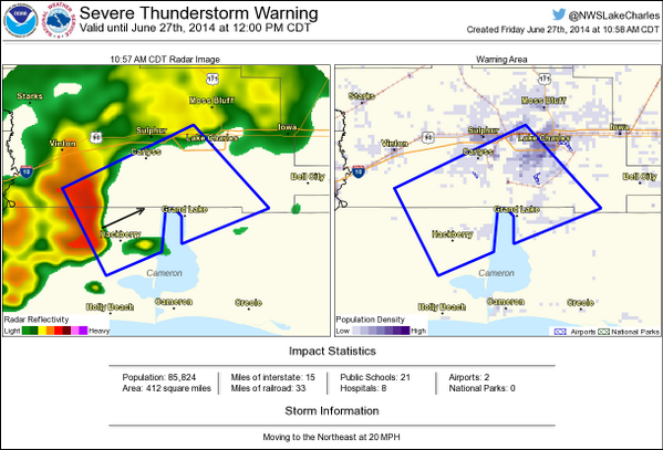
The morning quickly started with a storm moving on shore over Cameron parish producing a weak short lived tornado. This storm continued into Calcasieu parish where a Severe Thunderstorm Warning was issued for Calcasieu parish at 10:58 am. That storm produced locally heavy rainfall and the NWS issued a Flood Advisory at 11:23am with warning that 1-3 inches of rain could fall through 1pm along with a warning to never drive your vehicle into areas where the water covered the road.
At 11:39am the National Weather Service advised on social media that as the heavy rain continued local street flooding could occur in Lake Charles and Moss Bluff.
Street flooding could begin to occur shortly across parts of Lake Charles and Moss Bluff as very heavy rainfall continues.
— NWS Lake Charles (@NWSLakeCharles) June 27, 2014
At 11:53am the NWS issued a new Severe Thunderstorm Warning for the same storm moving into eastern Calcasieu parish.
At 12:57pm, the NWS issued a Flash Flood Warning for Eastern Calcasieu Parish shown in the figure below.

At 1:18 pm enough rain had fallen and more was forecasted that the NWS issued a Flash Flood Watch for Calcasieu Parish and the surrounding parishes westward through 12:00am. At 2:45pm a Tornado Warning was issued for eastern Calcasieu Parish and continued moving into Jefferson Davis Parish.

Here is a video of the radar during the tornado.
At 3:26 pm, the NWS issued another Flash Flood Warning for Eastern Calcasieu parish including Iowa and Hayes explaining that 1-3 inches of rain had already fallen with the potential of 2-4 more inches through 5:00pm.
At 4:55pm those Flash Flood Warnings were transitioned into Flood Warnings that said 3-7 inches of rainfall had fallen, but stream gauges were indicating that water levels had crested and were beginning to fall slightly but that there were still many roads flooded across the warned area. At 9:45pm, River Flood Warnings were issued for both Old Town Bay and the Salt Water Barrier for minor flooding to be expected. As of 10:58pm the flood warning was expired as local law enforcement reported that most of the flooded roadways were now passable.
A total rainfall map for Calcasieu Parish follows below:


 Follow us on YouTube