Hurricane Humberto
Rainfall
|
HURRICANE HUMBERTO
Official Storm Total Rainfall from 12am 9/12/07 to 12am 9/14/07
|
|
LOCATION
|
STORM TOTAL RAINFALL (inches)
|
| Beaumont/Port Arthur SE TX Regional Airport |
6.23 |
| Alexandria Int'l Airport LA |
3.48 |
| Alexandria Esler Field LA |
3.20 |
| Lafayette Regional Airport LA |
3.09 |
| Lake Charles Regional Airport LA |
3.08 |
| New Iberia Acadiana Regional Airport LA |
2.27 |
| Salt Point LA |
1.27 |
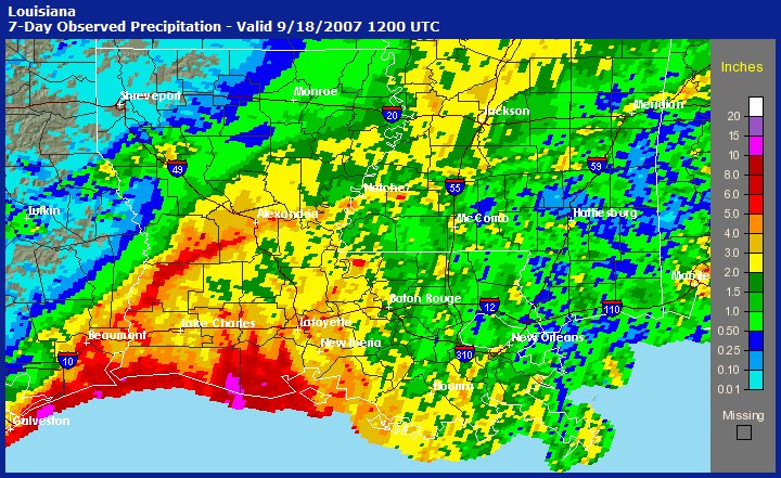 |
Storm Total Precipitation
for Southeast Texas and Louisiana
for Hurricane Humberto
(click on image for larger version)
|
|
|
|
|
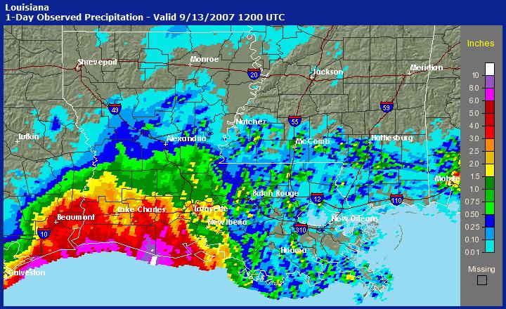
24-hour Total Precipitation
for Southeast Texas and Louisiana
from 7am on 9/12/07 to 7am on 9/13/07
(click on image for larger version)
|
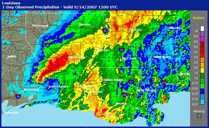
24-hour Total Precipitation
for Southeast Texas and Louisiana
from 7am on 9/13/07 to 7am on 9/14/07
(click on image for larger version)
|
|
HURRICANE HUMBERTO
COOP Storm Total Rainfall from 7am 9/11/07 to 7am 9/14/07
|
|
LOCATION
|
STORM TOTAL RAINFALL (inches)
|
| De Ridder LA |
8.25 |
| Beaumont TX |
6.58 |
| Abbeville LA |
5.70 |
| Lake Arthur 10 SW LA |
5.47 |
| Orange 9 N TX |
5.24 |
| Elmer 2 SW LA |
4.76 |
| Jennings LA |
4.63 |
| Boyce 7 SW LA |
4.43 |
| Jeanerette LA |
4.00 |
| Rosepine Research Station LA |
3.99 |
| Crowley 2 NE LA |
3.73 |
| Moss Bluff LA |
3.53 |
| Lake Charles 7 NW LA |
3.45 |
| Lumberton TX |
3.32 |
| Alexandria LSU Dean Lee LA |
3.31 |
| Alexandria Power Plant LA |
3.30 |
| Port of Lake Charles LA |
3.24 |
| Franklin 3 NW LA |
3.09 |
| Alexandria 5 SSE LA |
3.03 |
| Lafayette LA |
3.01 |
| Eunice LA |
2.91 |
| St. Martinville 3 SW LA |
2.82 |
| Lake Charles 2 N LA |
2.68 |
| Bunkie LA |
2.67 |
| Leesville LA |
2.65 |
| Grand Coteau LA |
2.62 |
| Boyce 3 WNW LA |
2.42 |
| Oberlin Fire Tower LA |
2.36 |
| Opelousas LA |
2.18 |
| Silsbee 4 N TX |
2.15 |
| Carencro LA |
2.02 |
| Red River Lock #2 LA |
2.01 |
| Morgan City LA |
1.40 |
| Wildwood TX |
0.22 |
|
HURRICANE HUMBERTO
Jefferson County Drainage District #6 Rain Gages
Storm Total Rainfall from 9/12/07 to 9/13/07
|
|
LOCATION
|
STORM TOTAL RAINFALL (inches)
|
| 5250 Winnie Wetlands at Mayhaw bayou TX |
10.71 |
| 5600 State Highway 124 at North Fork Taylor Bayou |
9.18 |
| 7200 Mayhaw bayou at Englin Road TX |
9.02 |
| 7300 Keith Lake at Highway 87 at Junior's TX |
8.74 |
| 6700 Cattle Walk at Ditch 550 TX |
8.62 |
| 7600 Marsh Unit at Highway 87 at Park Road 69 TX |
8.54 |
| 3200 Green Acres/LNVA Cheek Canal at Ditch 407 TX |
8.39 |
| 8000 Gulf Intracoastal Waterway at Chevron Duck Camp TX |
8.35 |
| 6500 Sabine Ranch at Ditch 550 TX |
8.27 |
| 7100 Mayhaw Bayou at Brush Island Road TX |
8.19 |
| 7800 Clam Lake Road at Ten Mile Cut Bridge TX |
8.07 |
| 2400 MHMR South 8th at Washington Blvd at Ditch 110 TX |
7.96 |
| 2300 State Highway 124 at Hillebrandt Bayou TX |
7.75 |
| 7900 Star Lake at Gulf Intracoastal Waterway TX |
7.67 |
| 2500 Highland Avenue at Ditch 104 TX |
7.64 |
| 7000 Mayhaw Bayou at Wilber Road TX |
7.52 |
| 6600 Labelle Ranch Property at Ditch 552-A TX |
7.24 |
| 3300 Labelle Road at Pevito Bayou TX |
7.17 |
| 7700 Stupka's Camp at Gulf Intracoastal Waterway TX |
7.12 |
| 2800 Walden Road at Ditch 202 TX |
7.08 |
| 2200 Washington Blvd. at Caldwood Cutoff TX |
7.08 |
| 7500 Gulf Intracoastal Waterway at State Highway 87 Bridge TX |
7.04 |
|
|
|
| Page last modified: September 18, 2007 |


 Follow us on YouTube