|
HURRICANE IKE |
NWS Lake Charles Office Web Log
A log of events and information received at NWS Lake Charles
1:15 AM - The latest storm surge level at Sabine Pass, TX is 12.54 feet MLLW, which is the highest ever recorded at that location, beating the storm surges from Hurricane Audrey and Hurricane Rita.
1:10 AM - A wind gust of 87 mph was measured at the Southeast Texas Regional Airport in Beaumont, while a wind gust of 64 mph was measured in Lake Charles.
12:40 AM - A large power flash was witnessed lighting up the sky north of the NWS Lake Charles office, with power being knocked out for a few minutes in the area. Several power surges and brief outages are continuing at the NWS office.
12:35 AM - The NOS Tide Gage at Sabine Pass is now measuring winds of 67 mph gusting to 95 mph!
12:30 AM - A wind gust of 63 mph was just measured at Lake Charles,
12:25 AM - Hurricane-force wind gusts are now occurring in the Beaumont/Port Arthur area. A wind gust to 84 mph (73 knots) was just measured at the Southeast Texas Regional Airport in Nederland.
12:20 AM - As if storm surge values weren't already high enough, they keep rising. Here are the latest peak levels in Mean Lower Low Water:
Cameron LA- 11.51 feet - 10.11 feet above normal
Sabine Pass TX - 11.96 feet - 10.94 feet above normal
Port Arthur TX - 9.04 feet - 8.78 feet above normal
Rainbow Bridge TX - 6.69 feet - 6.59 feet above normal
11:15 PM - Winds just gusted at Lake Charles to 61 mph.
10:45 PM - Here are some recent wind reports from around the area:
Calcasieu Pass - 58 mph gusting to 69 mph
Sea Rim State Park - 52 mph gusting to 60 mph
Beaumont/Port Arthur - 50 mph gusting to 73 mph
Lake Charles - 31 mph gusting to 46 mph
Orange - 39 mph gusting to 50 mph
Sulphur - 35 mph gusting to 49 mph
Here are the latest storm surge levels from the coast:
Louisiana
Cameron - 10.81 feet - 10.04 feet above normal
Freshwater Canal Locks - 8.87 feet - 8.31 feet above normal
Amerada Pass - 5.36 feet - 5.00 feet above normal
Texas
Sabine Pass - 10.81 feet - 10.04 feet above normal
Port Arthur - 7.71 feet - 7.76 feet above normal
Rainbow Bridge - 5.77 feet - 5.68 feet above normal
8:45 PM - Here are some recent wind reports from around the area:
Calcasieu Pass - 54 mph gusting to 67 mph
Sea Rim State Park - 53 mph gusting to 61 mph
Beaumont/Port Arthur - 39 mph gusting to 49 mph
Lake Charles - 30 mph gusting to 43 mph
Orange - 26 mph gusting to 39 mph
Sulphur - 24 mph gusting to 36 mph
Jasper - 23 mph gusting to 35 mph
6:55 PM - Storm surge continues to rise across the area. Here are the latest peak storm surge levels measured so far:
Louisiana
Cameron - 9.97 feet - 9.49 feet above normal
Freshwater Canal Locks - 10.01 feet - 9.70 feet above normal
Amerada Pass - 8.02 feet - 6.75 feet above normal
Texas
Sabine Pass - 8.30 feet - 7.73 feet above normal
Port Arthur - 5.90 feet - 5.14 feet above normal
Rainbow Bridge - 4.77 feet - 3.89 feet above normal
5:40 PM - Several tornadoes are being reported across Central and Southern Louisiana. The earlier tornado in Mamou has reportedly damaged 10-15 homes and injured 1 person, and a mobile home was flipped onto a roadway. Click here for all of our latest tornado reports.
5:00 PM - Updated peak storm surge levels measured so far:
Cameron LA - 9.10 feet - 7.81 feet above normal
Sabine Pass TX - 7.69 feet - 6.09 feet above normal
Freshwater Canal Locks LA - 9.92 feet - 8.59 feet above normal
Amerada Pass LA - 8.02 feet - 6.75 feet above normal
Port Arthur TX - 5.77 feet - 4.68 feet above normal
Rainbow Bridge TX - 4.60 feet - 3.71 feet above normal
4:45 PM - Numerous tornado warnings are now being issued, with one tornado reported in Mamou with damage to homes. See all of our latest tornado and hurricane reports via our Local Storm Reports.
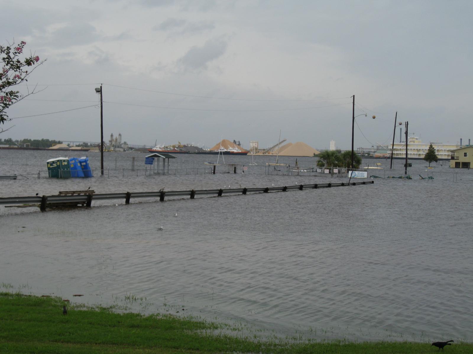
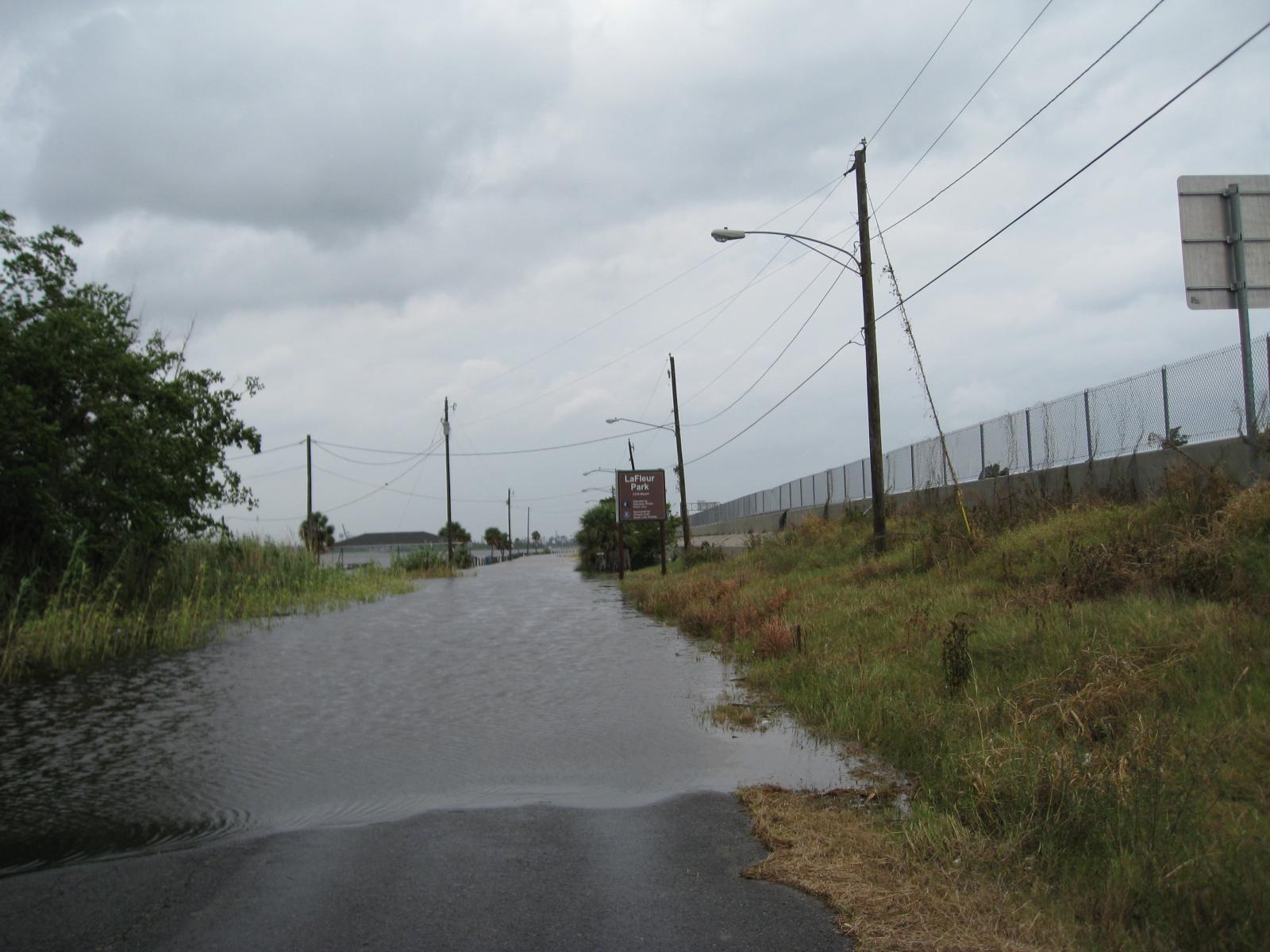
4:30 PM - Jonathan Brazzell, Service Hydrologist, along with Sam Shamburger, Forecaster, and Montra Lockwood, Forecaster, took these pictures of storm surge flooding in Lake Charles around 4 PM. Click on each image for a larger picture!
 I-10 Beach at I-10 Bridge |
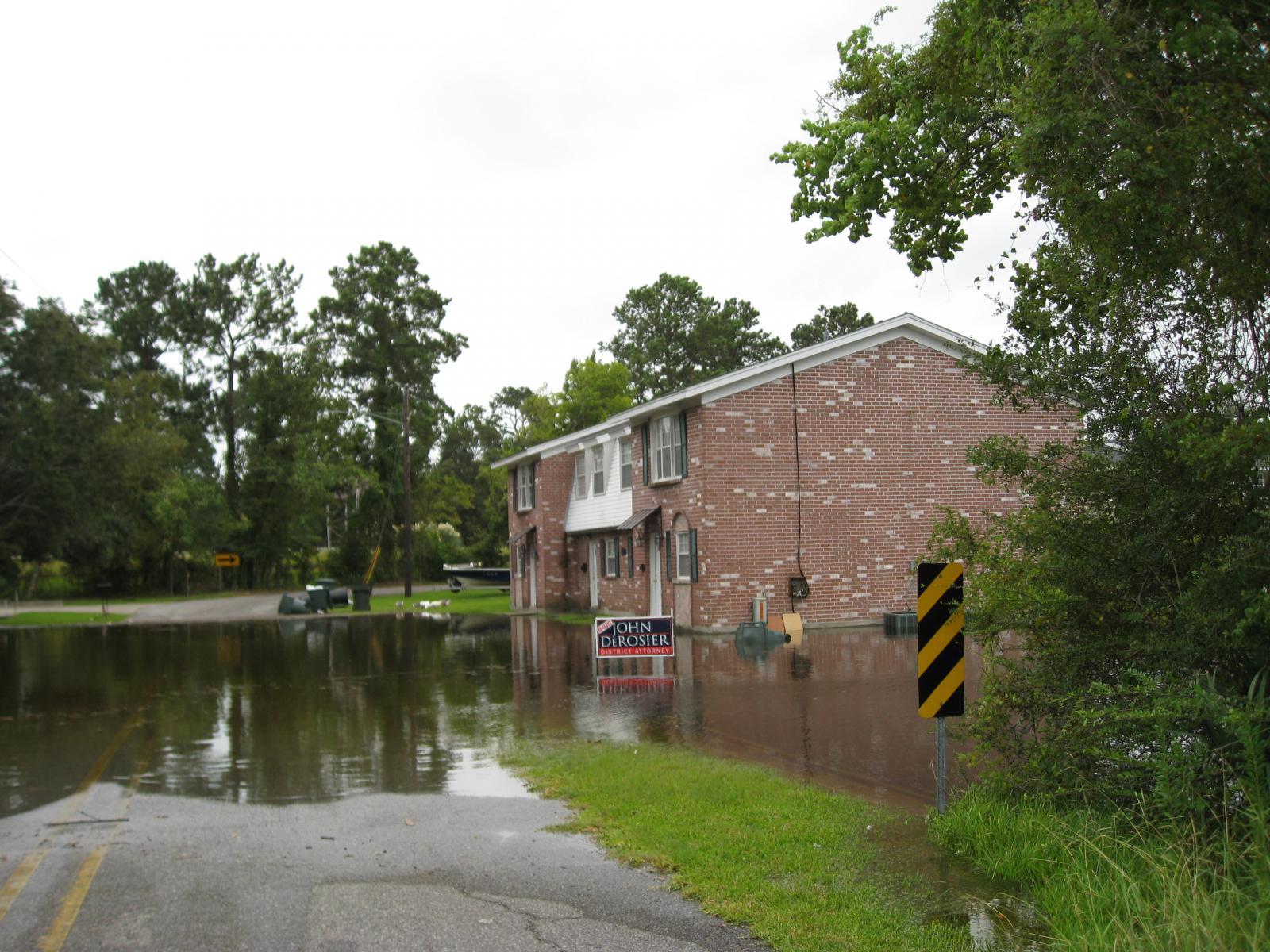 Lake Street at Prien Lake Road |
 I-210 Beach near I-210 Bridge |
4:05 PM - The 4 pm advisory from the National Hurricane Center has been issued and the center of Ike is now about 175 miles south of Lake Charles or about 145 miles south of Cameron. Max sustained winds remain near 105 mph. Next scheduled update comes around 4 pm. Click here for the full advisory.
3:00 PM - Calcasieu Pass (Cameron) reported a gust to 64 mph at 2:10 pm.
2:30 PM - Updated surge levels from the past hour:
Cameron - 8.87 feet - 7.09 feet above normal
Sabine Pass - 7.45 feet - 5.87 feet above normal
Freshwater Canal Locks - 9.64 feet - 8.23 feet above normal
Amerada Pass - 7.87 feet - 6.59 feet above normal
2:15 PM - Observations from the top of the hour show winds continue to pick up. Beaumont/Port Arthur had a gust to 53 mph, while New Iberia reported another gust to 44 mph. Meanwhile, Marsh Island reported our first gust to hurricane strength back around the 1 o'clock hour...75 mph.
2:00 PM - Roger Erickson, Warning Coordination Meteorologist, and Montra Lockwood, Forecaster, just returned from a quick survey of area waterways and reported that flooding was already occurring in the Deatonville community between Lake Charles and Grand Lake. Also the Calcasieu Point Landing is under water.
1:30 PM - The tornado watch which had been in effect for South-Central Louisiana has expire and been replaced by a new watch which covers South-Central, Central and Southwest Louisiana. This watch is in effect until 10 pm. Click here for more info.
1:05 PM - Latest update from the National Hurricane Center is in, and the center of Ike is now about 195 miles due south of Lake Charles. This position is also about 165 miles south of Cameron. Max sustained winds remain near 105 mph. Next scheduled update comes around 4 pm. Click here for the full advisory.
1:00 PM - Storm surge levels continue to rise along the Southeast Texas and Louisiana coasts. As of 1 pm:
Cameron - 8.60 feet
Sabine Pass - 8.30 feet
Freshwater Canal Locks - 9.30 feet
Also, tropical storm force wind gusts of 44 mph have recently been reported at Beaumont/Port Arthur and Alexandria.
11:30 AM - Storm surge levels continue to rise along the Southeast Texas and Louisiana coasts. As of 11:30 am:
Cameron - 8.02 feet
Sabine Pass - 5.78 feet
Freshwater Canal Locks - 8.86 feet
11:00 AM - Tropical Storm force wind gusts of 45 mph have now been reported at both Lake Charles and New Iberia.
10:30 AM - First confirmed tornado. Received verification of a tornado just northeast of Arnaudville in St. Landry Parish earlier this morning. Tornado touched down in an open field and no damage was reported.
8:15 AM - Storm surge levels continue to rise along the Southeast Texas coasts. As of 8:15 am:
Cameron - 6.56 feet
Sabine Pass - 5.58 feet
Freshwater Canal Locks - 7.80 feet
At these tide levels, the city of Cameron is underwater, and portions of Sabine Pass are underwater.
6:15 AM - First Tornado Warning of Hurricane Ike has been issued for St. Martin & St. Landry Parishes.
5:30 AM - Despite the northeast winds across the area, storm surge is already affecting the Southeast Texas and Louisiana coasts early this morning. The Cameron Parish Emergency Manager reported 4 feet of water in front of the Cameron Courthouse, and they were forced to leave Cameron and head for higher ground.


 Follow us on YouTube