|
|
NWS Lake Charles Office Web Log
A log of events and occurrences at the NWS office in Lake Charles, as well as other information coming into the office, to give you a feel of what it's like to work Hurricane Rita
Post Mortem - Well as you can see by the time listed below, and the fact that Rita's effects lasted far longer than 2 AM, something drastic happened...our data network failed. While voice communications both into and out of the office stayed up during the storm, we were no longer able to issue products on our own...nor could we update our homepage as usual. This was a failure similar to what happened after Hurricane Katrina hit the New Orleans area about a month earlier.
To summarize the events that followed our comms failure...the staff who rode out the storm in the office: organized the backup efforts that alternated between the San Antonio/Austin and Houston/Galveston NWS offices; listened to winds which slammed things into the building (or in the case of Joe & Sam, watched a transformer broken off a nearby light pole blow OVER the office), answered a ton of phone calls (even during the worst of the storm); and even ventured out and performed damage surveys of employees residences, as well as storm surveys around the Lake Area.
Special thanks go out to the following for their work above and beyond the call of duty: 1) Our crack electronics staff, who went out during the height of the storm to correct a failure in our doppler radar, located about 30 yards east of the operations building (but a 50 to 60 yard run from the back door); 2) Deputy Will Scheufens of the Calcasieu Parish Sheriffs Office, who provided security in the case of the worst, as well as constant communications with local law enforcement and emergency management; 3) Facilities technicians from NWS New Orleans and other parts of the NWS's Southern Region, who brought in much needed supplies after the storm and started us on the road to recovery; and finally 4) Four electronics technicians from the NWS's Central Region, who were sent to us to provide emergency repairs to our homes, in heat, humidity and mosquitoes none of which were anywhere used to dealing with...and did so without even a hint of complaining.
2:00 AM - The latest advisory from the NHC puts the center about 10 miles offshore of
Sabine Pass, with max winds still running at 120 mph. Speaking of max
winds, the office just had a gust measured at 75 knots or 86 mph. Sure
sounds a lot stronger...
2:00 AM - Due to the slow-moving nature of Rita, the tornado warning for extreme
winds in the eyewall has been extended until 4 AM, and is in effect for all
the same parishes and counties as before, plus Jeff Davis Parish. Here's
the link to it.
1:35 AM - Okay, it looks like my landfall projection was slightly premature, as
convection ahead of the eyewall pushed out slightly ahead of the actual
center, which now looks to still be 10 or so miles offshore. Also,
the strongest convection to affect the office is ongoing at this time. Cars in
the parking lot are rocking and rolling!
1:20 AM - Totally unofficial, but it looks here like Rita is currently making landfall near
Holly Beach and Constance Beach along the Cameron Parish coast. We'll
have to wait to see where and when NHC places official landfall.
1:10 AM - The 1 AM position estimate out of NHC put the center about 30 miles
southeast of Sabine Pass. Also, we just measured a gust to 71 knots here
at the office, which we still believe was on the low side of accurate.
12:50 AM - Tornado warnings issued for Avoyelles and Rapides Parishes, based on a
radar-depicted cell capable of producing a quick spin up. Eyewall tornado
warnings were also issued earlier for Cameron and Calcasieu Parishes,
as well as Jefferson and Orange Counties.
12:30 AM - The NOS gage at Calcasieu pass just reported a peak gust of 97 knots, or
112 mph!!
12:25 AM - We've been sharing the wealth around this evening as far as doing live
interviews with KPLC. Joe got his chance a couple of hours ago, and now
Donovan's taking his turn. Click here for a pic.
12:15 AM - Peak wind gusts from official reporting stations around the forecast area, as
of Midnight:
* Lake Charles 69 knots/79 mph #
* Beaumont 70 knots/81 mph
* New Iberia 51 knots/59 mph @
* Lafayette 45 knots/52 mph
* Fort Polk 40 knots/46 mph
* DeRidder 36 knots/41 mph
* Jasper 36 knots/41 mph
* Alexandria 33 knots/38 mph
# Official equipment has died, and it is the firm belief of the forecasting staff
that the backup equipment is underestimating the wind speed based on the
howling we're hearing outside
@ Unit here has also malfunctioned...last full observation came in at 7 PM
12:00 AM - Happy Saturday. Per the latest NHC advisory, the center of Hurricane
Rita is approximately 40 miles south-southeast of Sabine Pass, moving
northwest at 11 mph. The advisory also states that Cameron had a peak
gust of 98 mph!
11:40 PM - The observing unit at Sea Rim State Park now reporting sustained winds
of 61 knots/70 mph...gusts to 72 knots/83 mph.
11:30 PM - The office is receiving numerous phone calls from people who didn't leave
before the storm, saying they want to leave now. PLEASE stay sheltered
in place at this time...it's far too dangerous outside and on the roads!!
11:00 PM - Sea Rim State Park, along the coast south of Beaumont, just gusted to
hurricane force (66 knots/76 mph)
10:50 PM - Newest Hurricane Local Statement is available.
10:40 PM - Peak wind gusts from official reporting stations around the forecast area, as
of 10:30 PM:
* Lake Charles 64 knots/74 mph
* Beaumont 54 knots/62 mph
* New Iberia 51 knots/59 mph
* Lafayette 44 knots/51 mph
* DeRidder 36 knots/41 mph
* Fort Polk 36 knots/41 mph
* Jasper 36 knots/41 mph
* Alexandria 33 knots/38 mph
10:30 PM - The backup batteries in the airport's observing unit finally died. We have
switched to a backup unit, although observations will not be issued.
However, it will be a way for us at the office to gauge the wind outside...and
you can be sure we'll be posting updates here!
10:25 PM - Some unconfirmed reports to share...
* 50 to 55 mph winds in Stephensville (Lower St. Martin Parish)
* Storm surge of unknown depth hammering Pecan Island (Vermilion
Parish)
* An 18-wheeler flipped on I-10 at mile marker 29, near Westlake
(Calcasieu Parish) blocking both east and west-bound lanes
* Trees and power lines down all over Acadiana
10:05 PM - We just issued our first tornado warning for intense winds in the eyewall...it's
in effect until midnight for Cameron Parish and Jefferson County. Here's a
link!
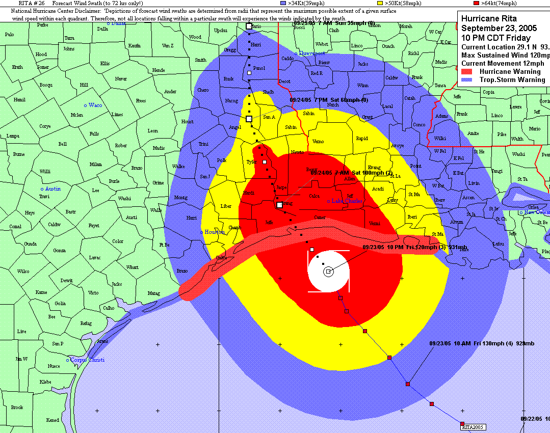
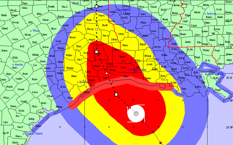
10:00 PM - Click here for an image of the latest forecast track of Rita.
9:35 PM - After doing a quick, impromptu survey of local media web sites, how come
none of them have a link to this site in their weather/hurricane link sections??
9:25 PM - Was just told that the number of regional or state conference calls we have
participated in over the past several days is 50...and we're not even close
to the end yet!
9:20 PM - Just got off the conference call with the National Hurricane Center. No
major changes to come with this forecast package, other than reducing the
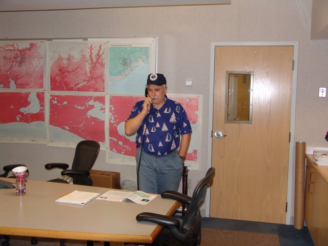
intensity to 105 knots/120 mph. Click here for a pic of the staff listening in.
9:15 PM - We have achieved hurricane status...64 knot/74 mph wind gust at 9:07!
9:15 PM - Just stepped out the back door of the office to take a look at conditions
outside...needless to say it's ugly. The rain's only moderate at worst, but
blowing sideways...or swirling around in little eddies caused by anything
in its way. Looking to the south, west and north (toward the city), not a light
to be seen at all.
9:10 PM - This just in to the office...the Calcasieu Parish Office of Homeland Security
and Emergency Preparedness has issued a boil water order for the parish.
9:10 PM - With the power out at the airport, the automated observing unit on the runway
complex (the unit which supplies the official hourly weather for Lake Charles)
has only about 30 more minutes of functionality before the backup batteries
run out.
8:50 PM - We just received phone calls of thanks from Calcasieu Parish Director of
Homeland Security, Dick Gremillion, and Congressman Charles Boustany.
Glad we can live up to their high expectations!
8:35 PM - The U.S. Geological Survey is reporting an earthquake, magnitude 5.0, in the
Gulf of Mexico, 530 miles south of Brownsville.
8:30 PM - The Lake Charles doppler radar is back online and is showing the strongest
winds yet on their way to Southwest Louisiana...estimated at 70 to 80 knots
(roughly 80 to 90 mph).
8:20 PM - Forgot to mention that at 7:30, commercial power to the building failed and
the office generators kicked on.
8:00 PM - Now it's Steve's turn to do a live phone interview with KPLC...click here for
a pic.
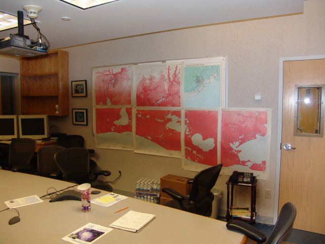
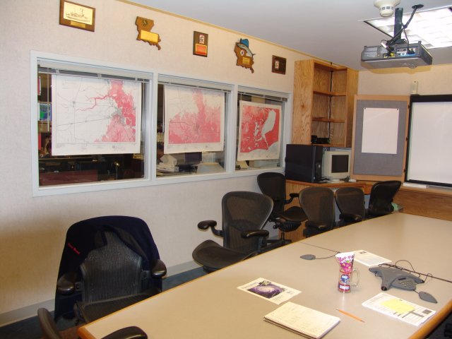
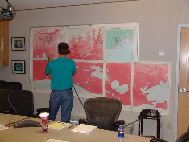
8:00 PM - Various members of the staff have done a countless number of conference
calls and interviews the past few days. Command central for these calls has
been our conference room, where a recent addition has been several maps for
quick access to needed info. Here's a couple of pics: 1 2
7:50 PM - 71 mph gust!!!
7:35 PM - The office just had its highest gust so far...52 knots/60 mph. Our radar also
failed. Don't know if these two events are related...
7:10 PM - First staff meeting of the evening. Discussed protocol in case of an
emergency at the office tonight or tomorrow.
6:50 PM - Click here for an image of the latest forecast track of Rita.
6:30 PM - Recent recon report indicates that Rita has 3 concentric eye walls...the outer
one being 80 nautical miles from the center. This would be what caused the
recent strong wind report from Cameron.
6:25 PM - Roger is currently doing a live interview with KPLC, talking about what
to expect as far as tidal flooding is concerned around the area. Click here
for a pic.
6:20 PM - Recent reports from Cameron show winds now gusting to 90 mph!
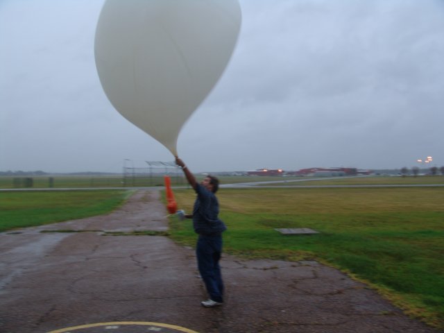
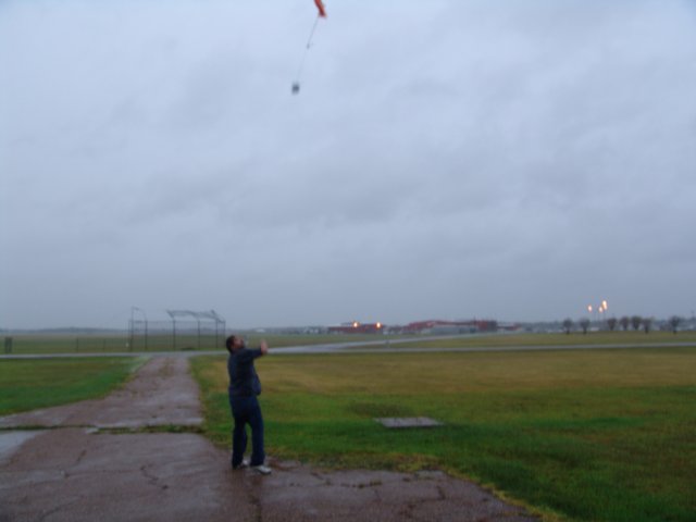
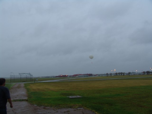
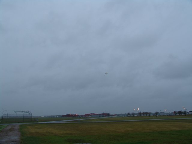
6:00 PM - Todd just launched the weather balloon in near tropical storm force winds.
The wind at a thousand feet was measured at 56 knots...and just about
hurricane force at two thousand!! Click the following for a series of pictures
from the launch: 1 2 3 4
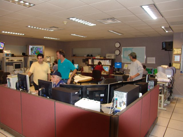
5:30 PM - Quick head count of the office staff shows 16 out of a possible 24 staff
members are in the building at this time. Also housing 1 spouse and 2 pets.
Makes for crowded conditions at times, but no fist-a-cuffs yet! Click here
for a picture of operations.
5:25 PM - First tornado report makes its way into the office. Tornado sighted in
Crowley at the corner of McCain Street and Highway 98. Storm was moving
southwest toward Estherwood.
5:00 PM - It's been an afternoon of increasing winds and rain across Southern Louisiana
and Southeast Texas. Numerous tornado warnings have been issued (although
actual sightings are limited), and wind gusts here at the office have finally
exceeded the 50 mph threshold. We will continue to post updates as they
happen.


 Follow us on YouTube