SAWRS Program
|
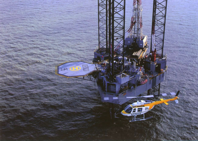
Supplemental Aviation Weather Reporting Stations SAWRS defined - A facility where weather observations are taken, prepared, and transmitted by a local operator (NWS certified) under federal government supervision. A SAWRS is established at an airport (includes offshore platforms' helipads) when the FAA has determined that the weather observations are needed to satisfy Federal Aviation Administration Regulations 121 or 135, or for the safe conduct of other aircraft operations. At present, WFO Lake Charles has 5 SAWRS located on oil platforms in the Gulf of Mexico. They are operated by PHI (Petroleum Helicopters, Inc.) and Air Logistics, Inc. We also have 3 inland sites.
|
OFFSHORE SITES
|
Site Name |
Station I.D. |
Coordinates |
Operator |
Location from Land |
|
High Island 264C |
28° 28" N 93° 44" W |
PHI |
80 NM South of Cameron |
|
|
South Timbalier 300 |
28° 09" N 90° 43" W |
PHI |
85 NM South of Houma
|
|
|
Mississippi Canyon 778 |
28° 11" N 88° 29" W |
Air Log |
100 NM South of Cameron |
|
|
Ship Shoal 207A |
28° 32" N 90° 59" W |
Air Log |
65 NM South of Houma |
|
|
South Marsh 268A |
29° 07" N 91° 52" W |
Air Log |
48 NM South Southwest of Morgan City |
|
Clicking a station I.D. will give you the station's latest weather information. |
|
PHI helicopter preparing to land on a platform in the Gulf of Mexico. |
INLAND SITES
|
Site Name |
Station I.D. |
|
Intracoastal City, La.* |
|
|
Amelia, La.* |
|
|
Creole, La.* |
|
|
Fourchon, La. |
|
|
Grand Isle, La.** |
|
|
Venice (Boothville), La. |
|
|
Ellington Field, Tx. |
|
|
* within NWS Lake Charles County Warning Area |
|
|
** temporarily inactive |
|
The HydroMet staff's duties are:
For more in-depth information on SAWRS, click here. For more about NWS certification, click here. A link to Gulf Coast observations can be found by clicking here. All observations are in METAR. A breakdown of the code can be viewed by clicking here. A link to conversion tables is also available. Click here. |


 Follow us on YouTube