|
A look back at 2007 showed it was an historic year in meteorological terms, with numerous records of all kinds being set, and several weather events causing significant property damage in the millions of dollars.
Below is a list of the Top 10 Weather Events of 2007 across Southeast Texas and Southwest Louisiana. Some weather events have webpages with more information - click on the weather event name to visit them!
| #1 |
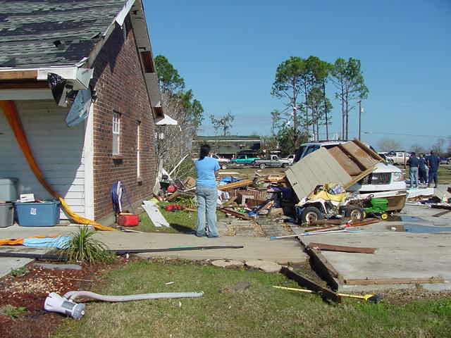
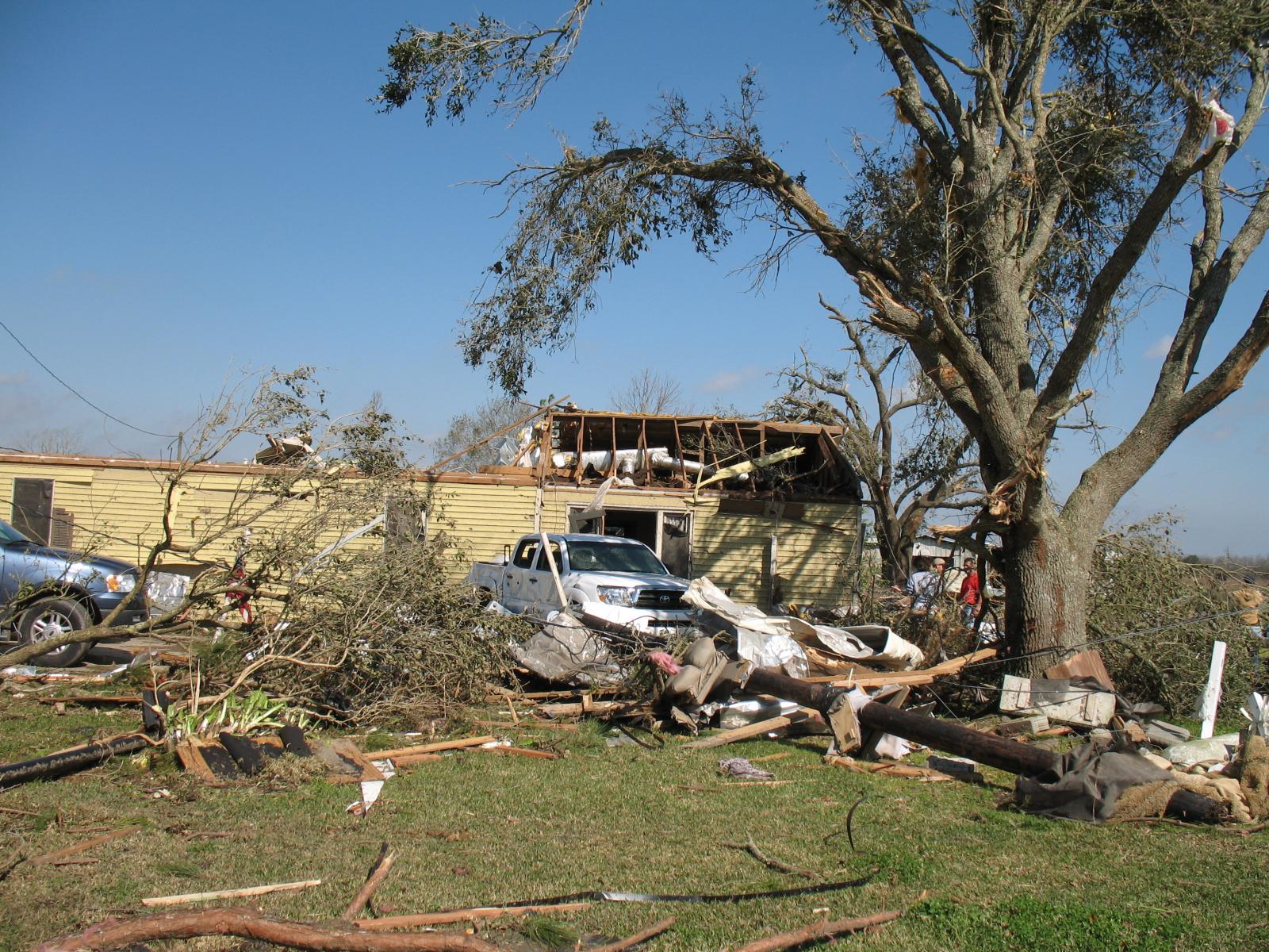
HURRICANE HUMBERTO |
|

September 13, 2007
|
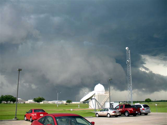
Hurricane Humberto developed extremely rapidly on September 12, 2007, before making landfall along the southwestern Jefferson County, Texas coast as a Category 1 hurricane early on the morning of September 13, 2007. Humberto made history due to its rapid strengthening from a tropical depression the morning of September 12, 2007, to a hurricane early on September 13, 2007, as no other hurricane has ever strengthened so quickly close to landfall. After making landfall between High Island, TX, and Sea Rim State Park, TX, the hurricane then tracked northeastward across Jefferson and Orange counties, impacting the Golden Triangle metropolitan area of Beaumont, Port Arthur, and Orange. This area had been severely damaged by Hurricane Rita just two years earlier. Although a small hurricane with a very tight wind field, Humberto caused considerable wind and flood damage across Jefferson and Orange counties, with numerous trees and power lines blown down along with some damage to structures. The storm knocked out power to 120,000 customers in the area. Damage estimates across Southeast Texas from Humberto were around $60,000,000. |
| |
|
| #2 |
NEW IBERIA TORNADO |
January 4, 2007
|
This tornado struck around 3:45 pm near the town of Lydia, then raced northeastward at 50 mph, before dissipating around 3:50 pm near a sugar cane factory northeast of New Iberia. The tornado was rated a strong F1 on the Fujita Tornado Scale with winds approximately near 110 mph. 2 people were killed and 15 other injured along the tornado's 15 mile path. Numerous homes were damaged or destroyed, with damage totals estimated around $1.5 million. |
| |
| #3 |
ACADIANA TORNADOES |
|
February 13, 2007
|
Four tornadoes struck south-central Louisiana between 12 am and 2 am, injuring 3 people and damaging over 100 homes. The strongest tornado, which struck near Breaux Bridge, was rated EF2 and was the strongest tornado to affect our area since 11/23/04. These severe storms also produced hail up to golf-ball size, damaging thunderstorm winds, and localized flooding.
These tornadoes were among the first in the country rated using the new Enhanced Fujita Scale, which replaced the original Fujita Scale on February 1, 2007.
|
| |
| #4 |
LAKE CHARLES HAILSTORM |
|
June 4, 2007
|
An isolated severe thunderstorm developed south of Lufkin, Texas, along an outflow boundary left from the complex of thunderstorms that affected the region on June 3rd. This storm moved southeastward at 35-40 mph for over 150 miles, producing numerous reports of large hail and wind damage across Southeast Texas and Southwest Louisiana.
The worst damage occurred as the storm moved across south Lake Charles, with numerous reports of high winds up to 80 mph, downed trees and power lines, and hail up to golfball size covering the ground. Damage totals from the hail and wind damage across Calcasieu Parish were around $500,000, making this the worst hailstorm in the history of Lake Charles.
|
| |
| #5 |
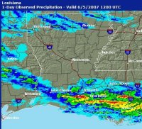
VERMILION PARISH FLOODING |
|
June 4, 2007
|
Showers and thunderstorms began developing early in the morning across Acadiana south of Lafayette along an outflow boundary left over from storms the previous day. By early afternoon, showers and thunderstorms (some even reaching severe levels) continued to regenerate along this boundary near Gueydan and moved eastward throughout the afternoon, leading to torrential rainfall in a narrow corridor across northern Vermilion Parish around Maurice. By Monday evening, radar had estimated that 10 to 15 inches of rain had fallen. This led to widespread flooding of over 50 homes in the area, some of which had reportedly never flooded before. Many roadways in the area were also submerged, including major thoroughfares such as Highway 167. |
| |
| #6 |
LATE SPRING SEVERE SQUALL LINE |
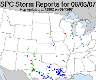
June 3, 2007
|
A line of severe thunderstorms developed in the morning hours across eastern Texas, then moved rapidly southeastward across the region. Numerous reports of wind damage, including downed trees, power lines, and roof damage, were received from this line of storms. Several locations measured wind gusts over 60 mph. The worst damage was across the northern Lakes Region of Southeast Texas, where power outages affected the area for several days. |
| |
| #7 |
EFFECTS OF TROPICAL STORM ERIN & HURRICANE DEAN |
|
August 16 & 22, 2007
|
Tropical Storm Erin and Hurricane Dean both made landfall well south of our region in southern Texas and Mexico during Mid-August. However, both storms cause moderate to high waves along our coastal areas, which combined with high tides to produce minor coastal flooding. This led to some school and roadway closures for several days. |
| |
| #8 |
AUGUST 2007 HEATWAVE |
|
August 8-14, 2007
|
A large and intense upper level ridge of high pressure centered over the southern United States brought record heat to Southeast Texas and Southwest Louisiana from August 8th through August 14th. Numerous locations saw temperatures rise over the 100 degree mark for the first time in one to two years. Some areas saw high temperatures soar to readings not seen since the record heat wave that occurred 7 years ago in the summer of 2000. This oppressive heat even lasted through the overnight hours, with temperatures only falling into the 70s and lower 80s at night. Numerous record high temperatures and warm minimum temperature records were set, and a few records were even the warmest minimum temperatures ever seen for the month of August.
These extreme temperatures, when combined with dewpoints in the upper 60s to middle 70s, led to dangerous heat index values in the 105 to 112 degree range during the late morning and afternoon hours across the area for several days...prompting near-daily heat advisories.
|
| |
| #9 |
EASTER WEEKEND WINTER STORM |
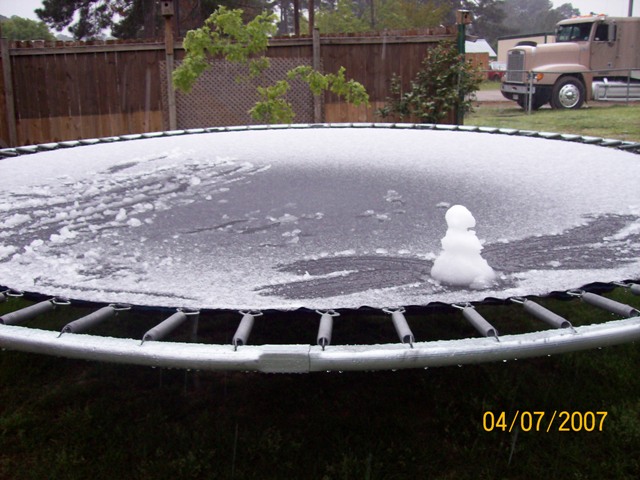
April 7, 2007
|
A winter storm affected the region well into the month of April, a very unusual time of year for winter precipitation across this part of the country. Despite temperatures above freezing, nearly all locations across Southeast Texas and Southwest Louisiana reported sleet. A mixture of snow and sleet fell across interior Southeast Texas and Southwest Louisiana, where some light accumulations occurred and prompted Winter Weather Advisories. This was the first winter precipitation observed in the month of April in 70 years. |
| |
| #10 |
UNUSUAL DECEMBER HEAT |

December 8-12, 2007
|
Southerly flow of warm humid air over a 5 day period gave the area an unusual stretch of record warm temperatures for December. Several record high temperatures and record warm minimum temperatures were set during this period. In fact, Alexandria tied their all-time December record high temperature of 83° on four of those five days (three of which were consecutive!). |
|


 Follow us on YouTube