
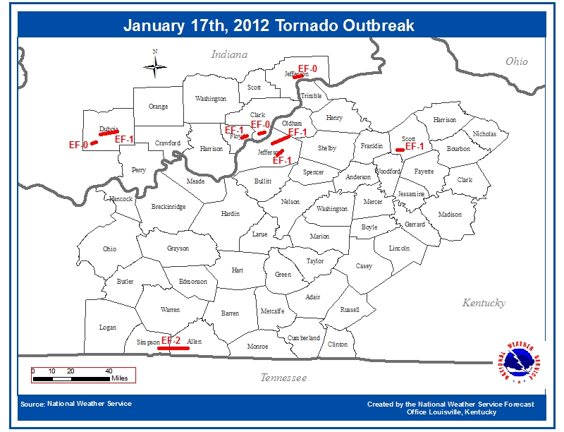
The Region's Most Prolific January Tornado Outbreak Ever Recorded
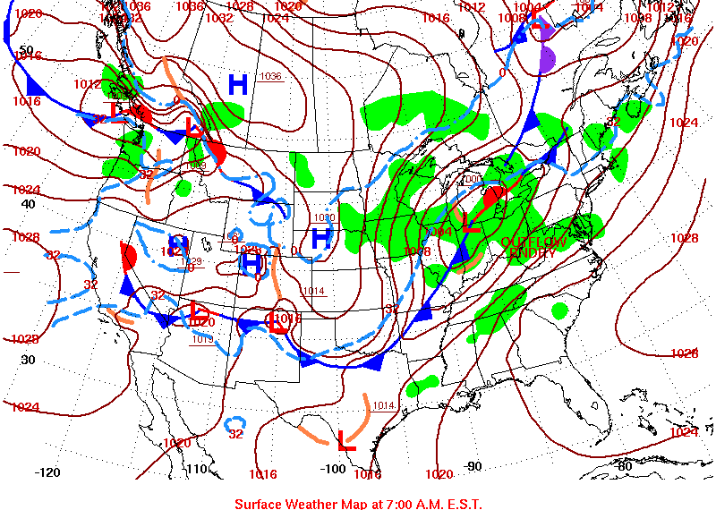
Early on the morning of Tuesday, January 17, 2012, a powerful squall line swept through southern Indiana and central Kentucky along a sharp cold front. Small circulations developed along the line, resulting in nine known tornadoes, mostly across southern Indiana and northern Kentucky. The Louisville metropolitan area appeared to be at the center of the tornado activity, with four tornadoes occurring within or just outside of the city.
 |
| Tornadoes |
 |
|
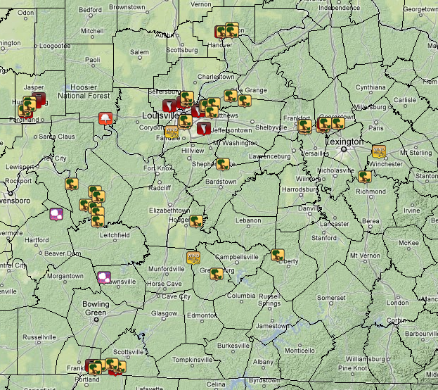
Reports of Severe Weather
The red icons indicate tornadoes, the yellow icons wind damage, the orange icon is a funnel cloud, and the pink icons represent hail. |
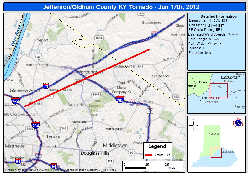
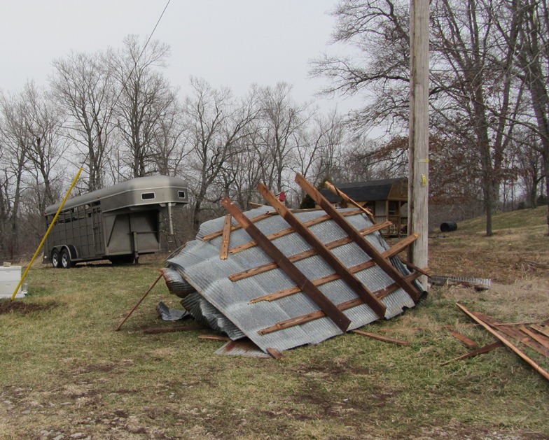
...EF-1 Tornado in northeast Jefferson County and Oldham County Kentucky...
Start time: 11:12am EST
End time: 11:21am EST
Wind speed: 95mph
Path length: 8.2 miles
Path width: 250 yards
injuries: 1
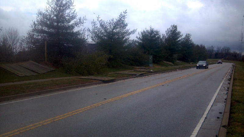
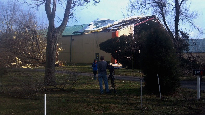
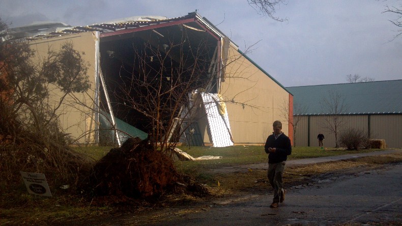
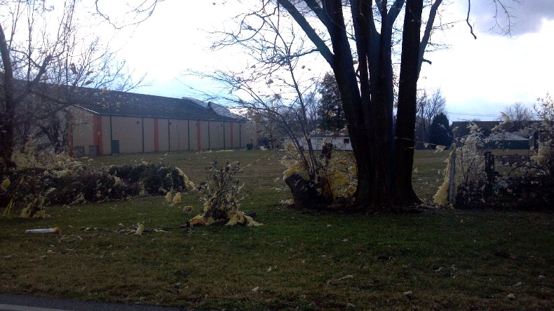
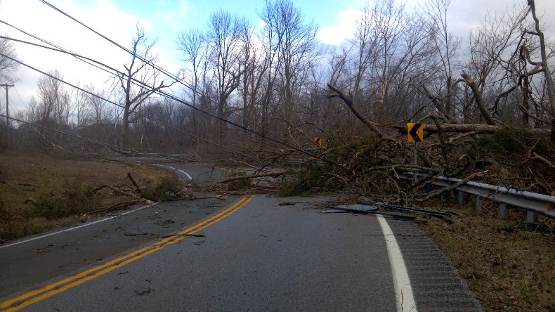
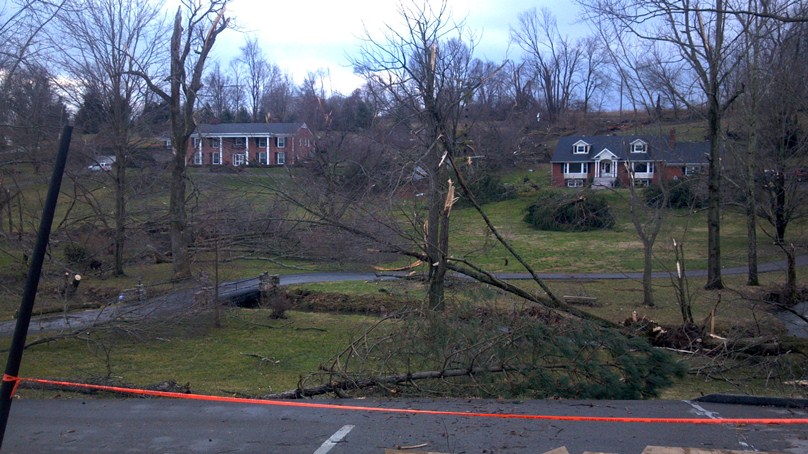
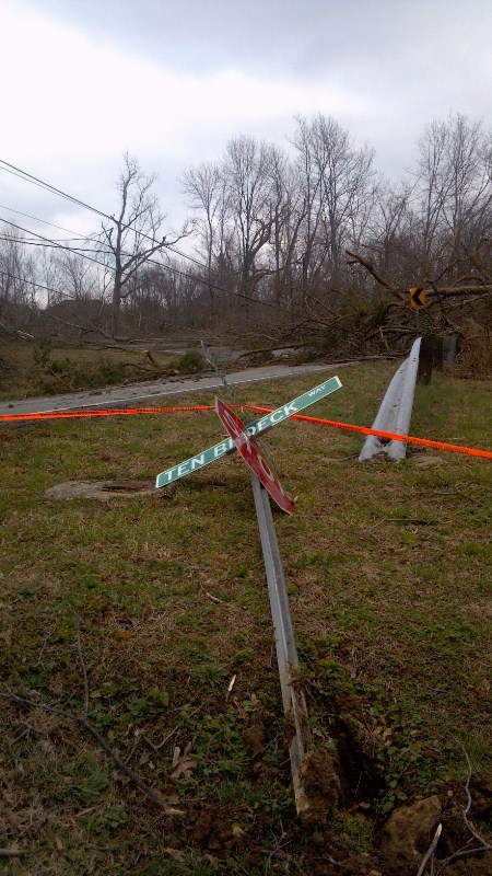
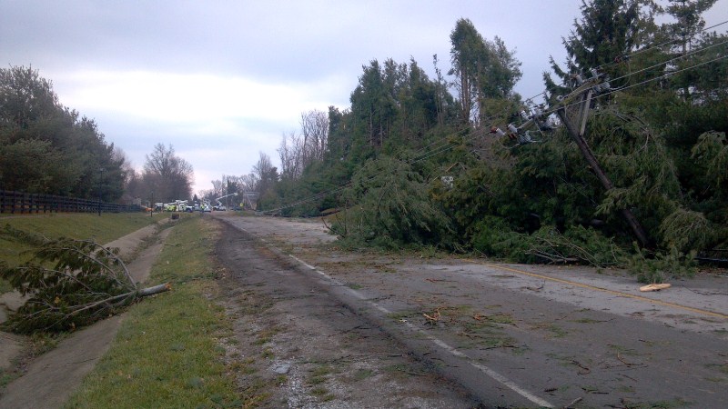
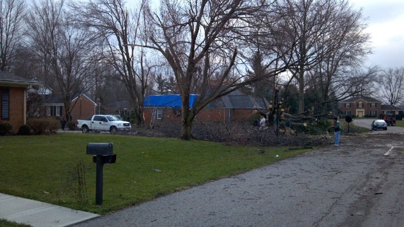
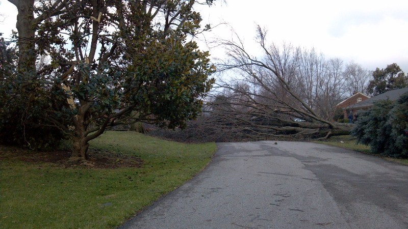
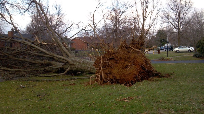
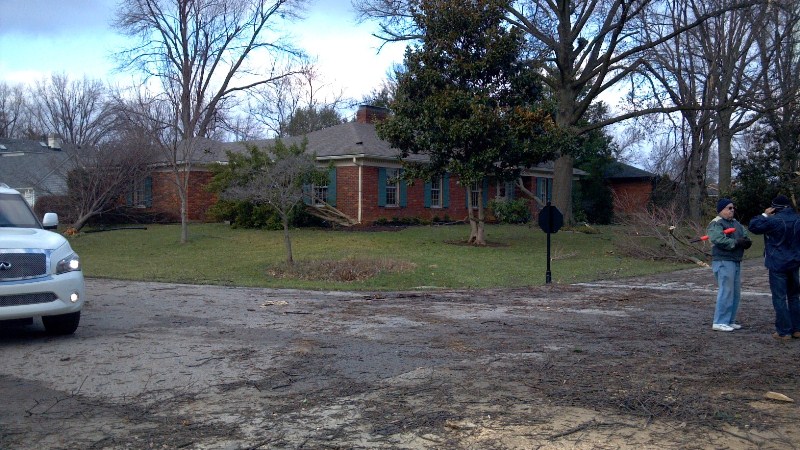
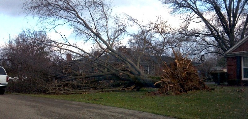
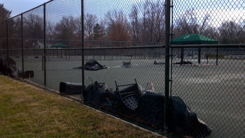
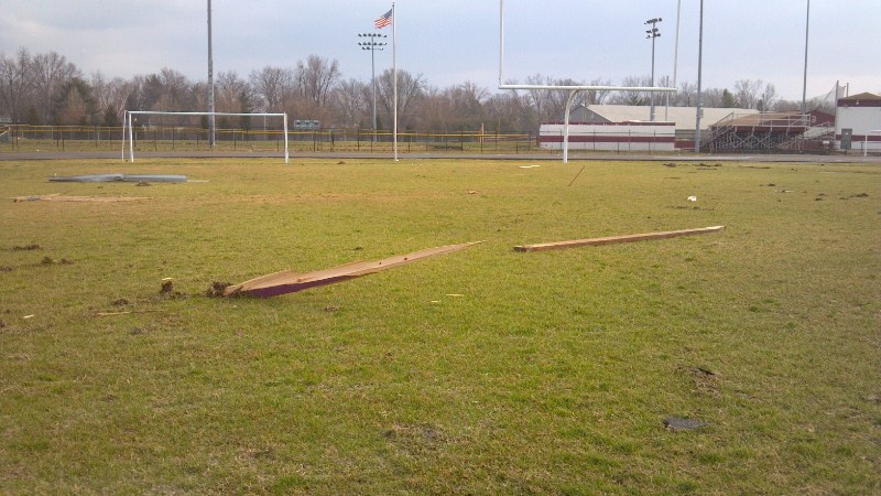
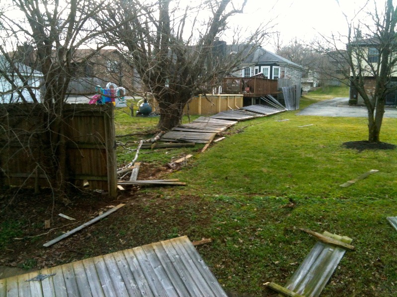
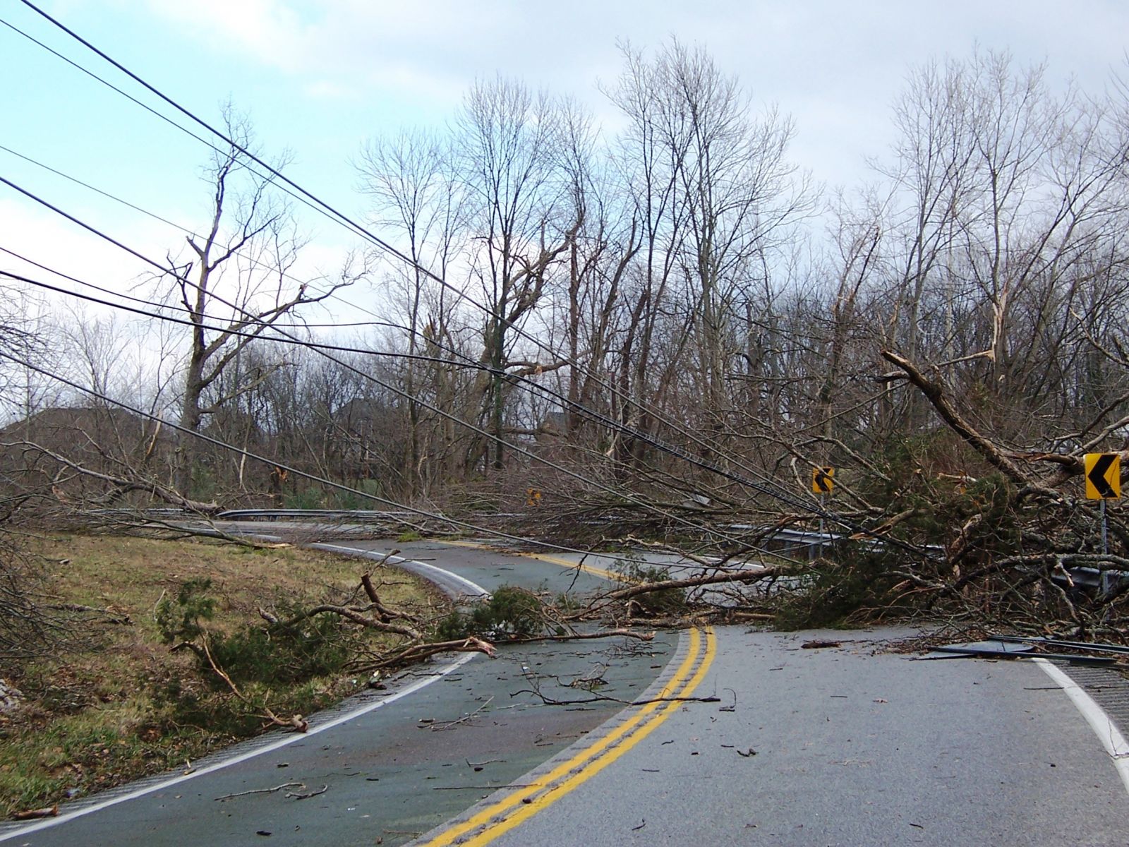
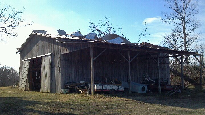
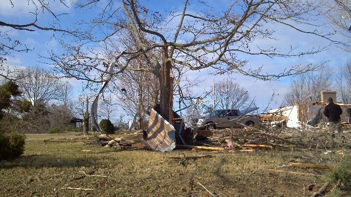
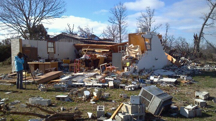
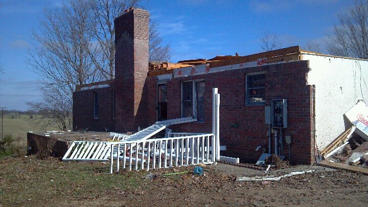
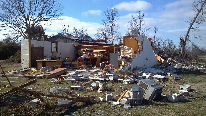
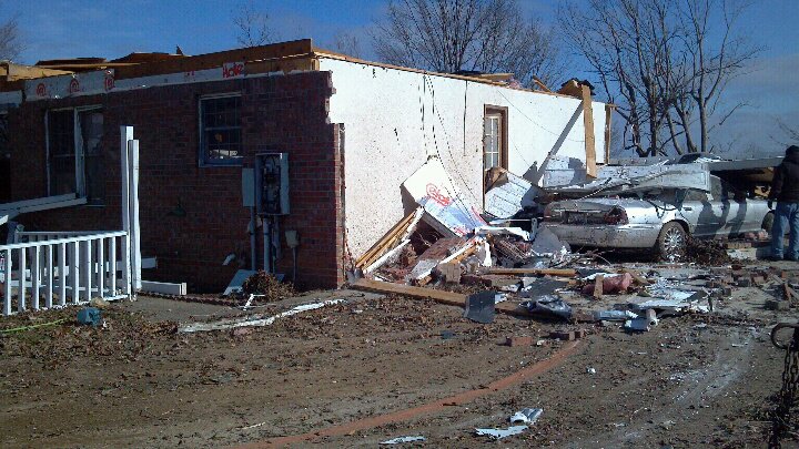
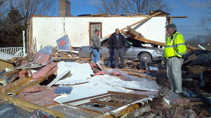
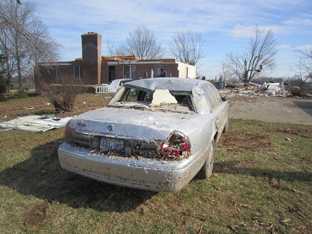
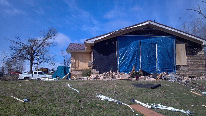
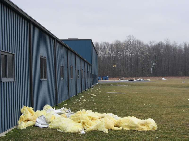
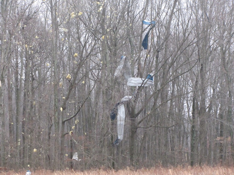
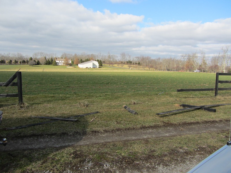
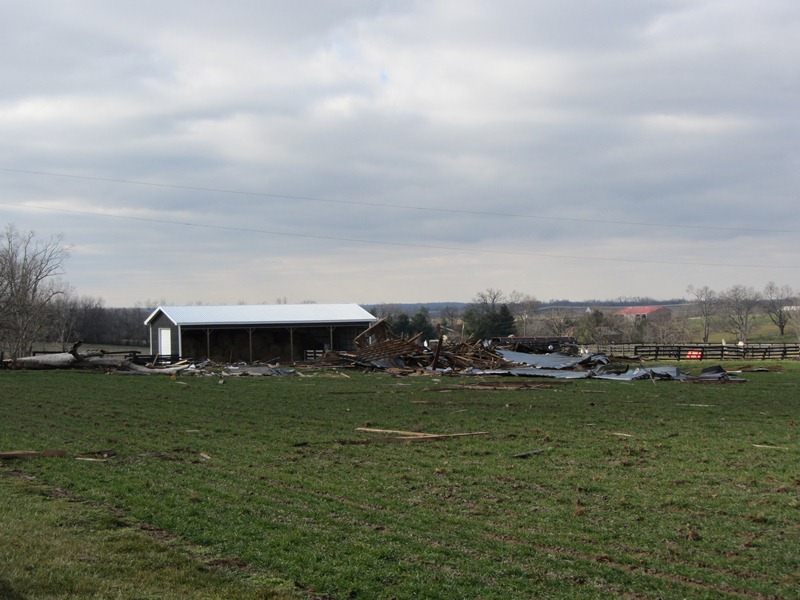
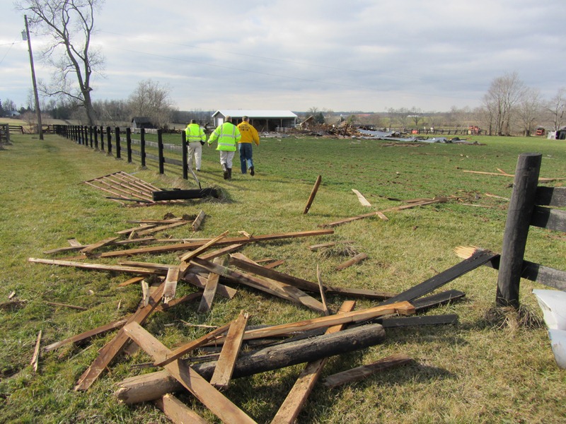
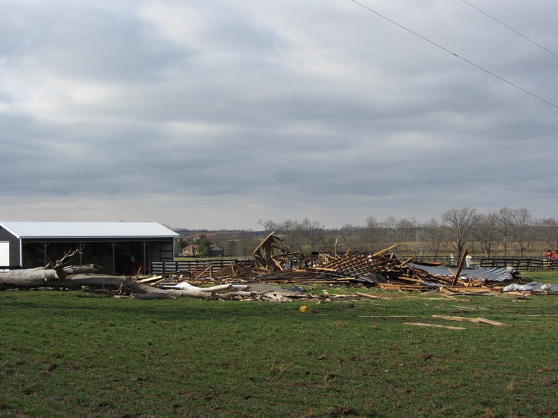
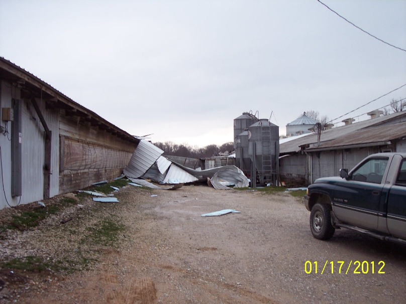
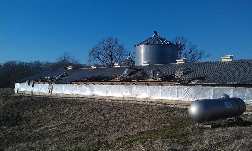
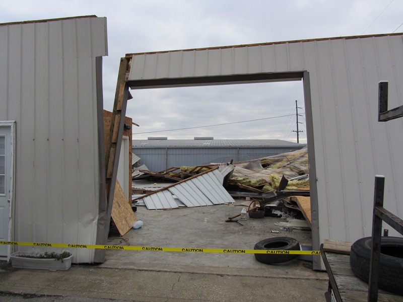
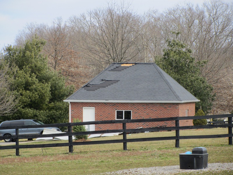
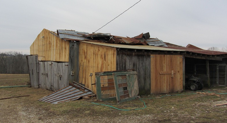
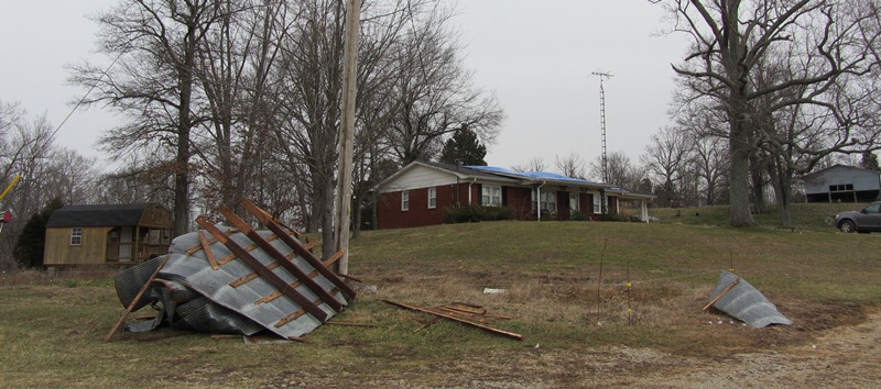
Narrative: The tornado touched down near the intersection of I-264 and Brownsboro Road. The tornado tracked northeast to near the intersection of Hurstbourne Lane and Brownsboro Road where it briefly lifted. The tornado then reformed and crossed I-265 and continued to the east-northeast through several subdivisions north and northeast of Fincastle. The tornado crossed into Oldham County, moving through Orchard Grass Hills and lifting at the northern tip of Clore Lane. Damage indicators along the path of this tornado included multiple softwood trees down, minor shingle damage to homes, a side wall downed in a large indoor tennis facility, and a barn roof collapse.
An injury occurred as the tornado crossed I-265 when two semi trailers were blown over. The driver of one of the trucks was injured.
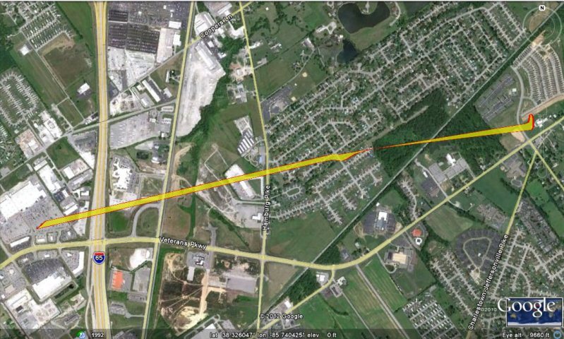
Click on the image below to see a map track:
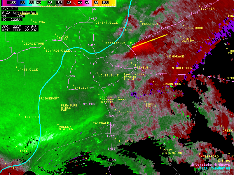
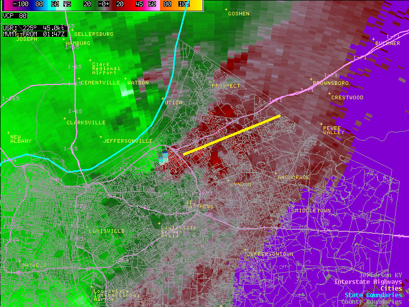
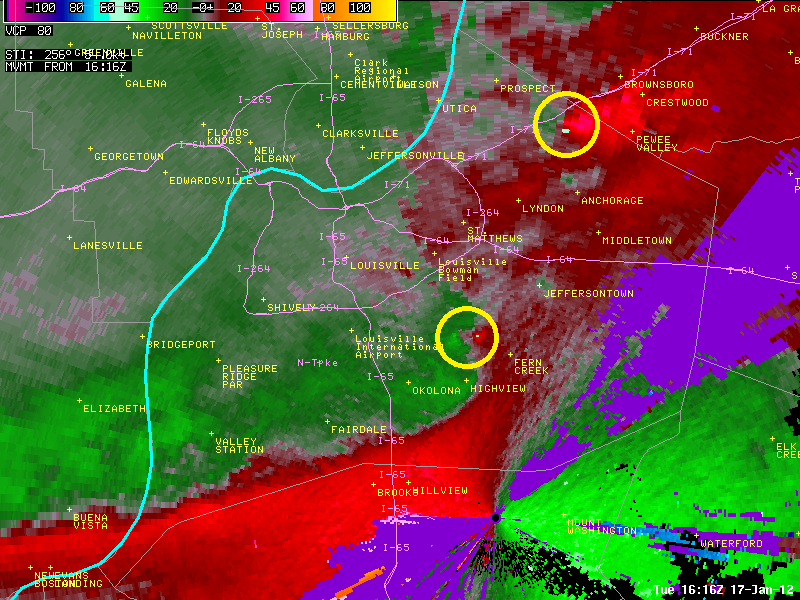
Below is a radar picture taken when the tornado first touched down. The bright green colors indicate air moving towards the radar (which is located at Fort Knox), and the bright red colors show strong winds moving away from the radar. When those two colors are close to each other, they imply that rotation exists at the interface between the opposing airstreams. The yellow line we plotted on the image shows the eventual track of the tornado. (Note the weak rotation beginning to form just north of Okolona, which would go on to become the tornado that struck near Fern Creek.) Click on the image to enlarge.
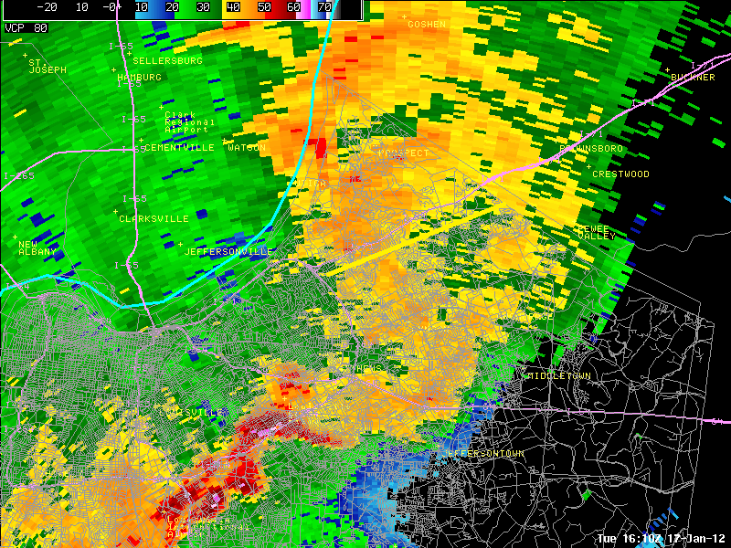
Here a couple more radar pictures, taken from a local radar near Mount Washington. We've zoomed in on northeast Jefferson County. In the picture on the left the radar is showing intense rotation just inside the Watterson, at an elevation of about 1900 feet. This rotation would spin down to the ground about a minute later, forming the tornado that went along Brownsboro Road. Again we have annotated the radar picture with the eventual tornado track. In the picture on the right, note how far back in the rain the tornado is located, and how the "reflectivity" (the yellows and greens) aren't really all that impressive -- no big areas of red or pink showing up. This is typical with small tornadoes that spin up in squall lines.
 |
 |
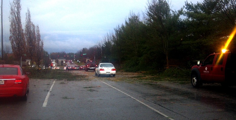
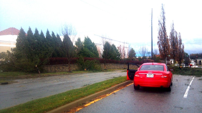
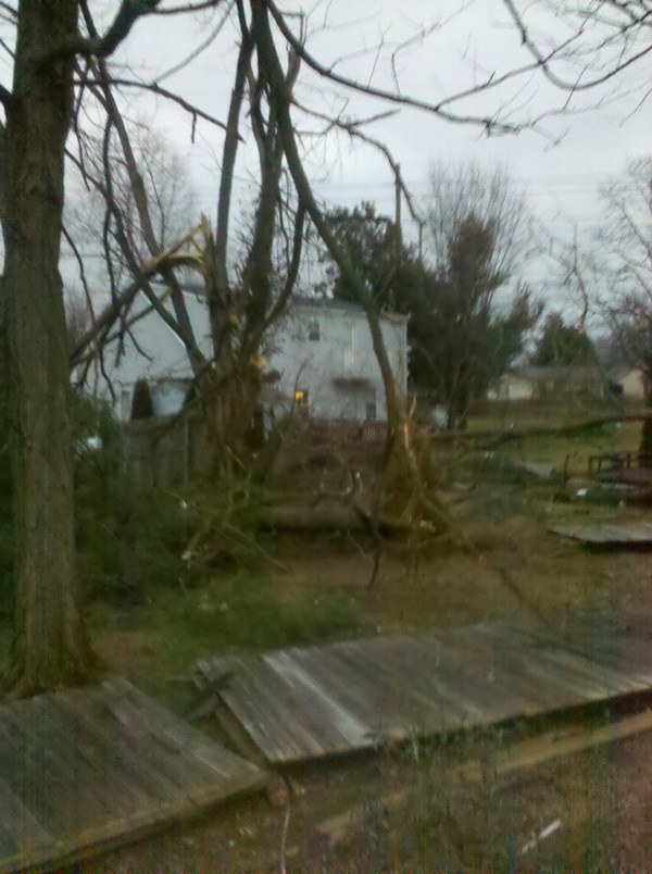
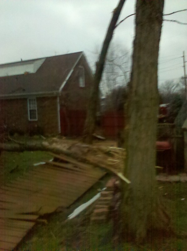
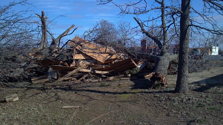
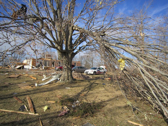
The following image is a still from a video shot by Rebecca Durham, who was near the intersection of Goose Creek Road, facing towards Brownsboro Road (click on the image for a larger version):

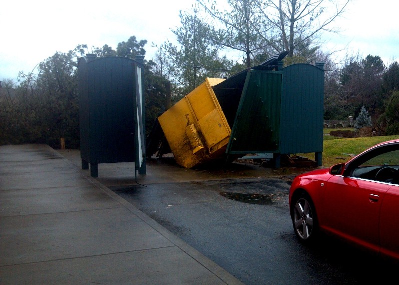
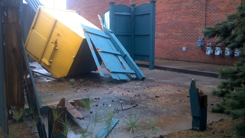
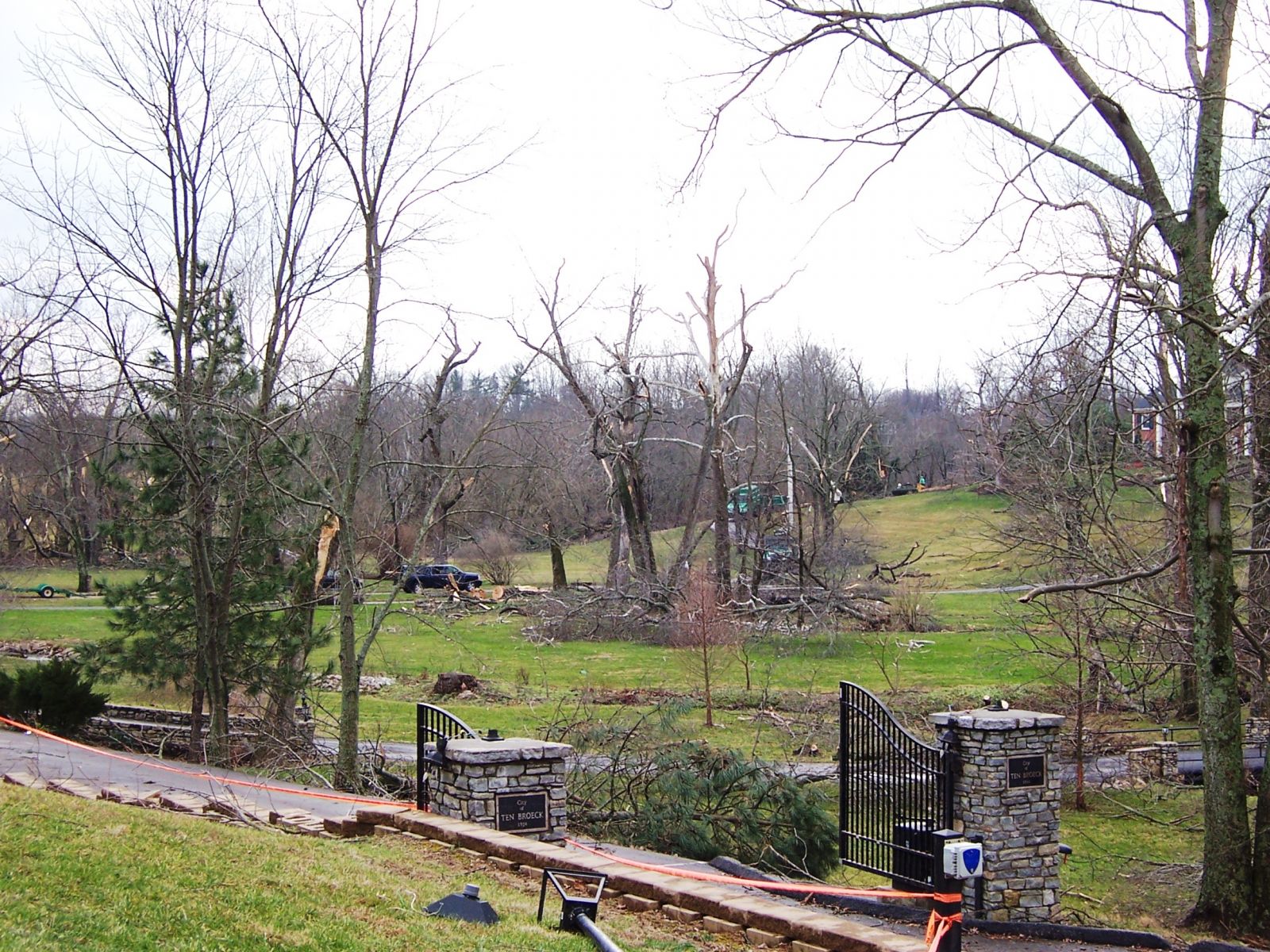
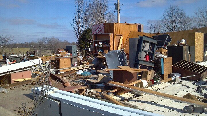
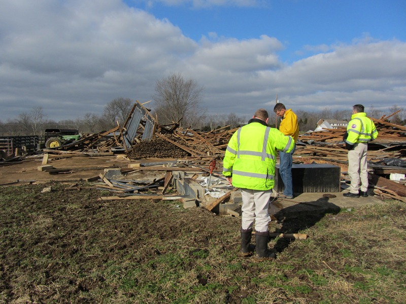
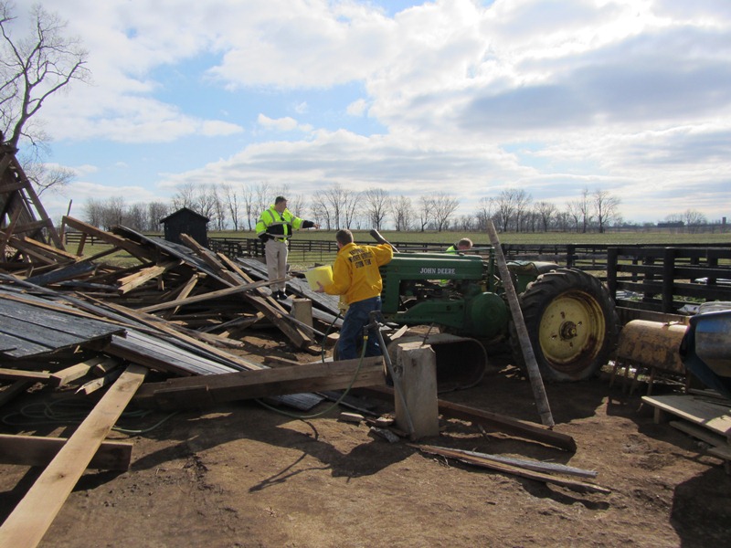
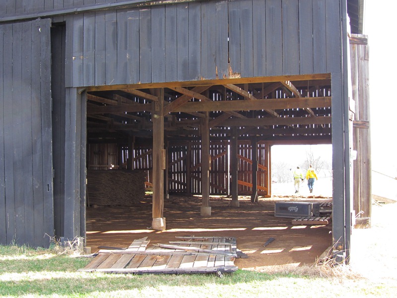
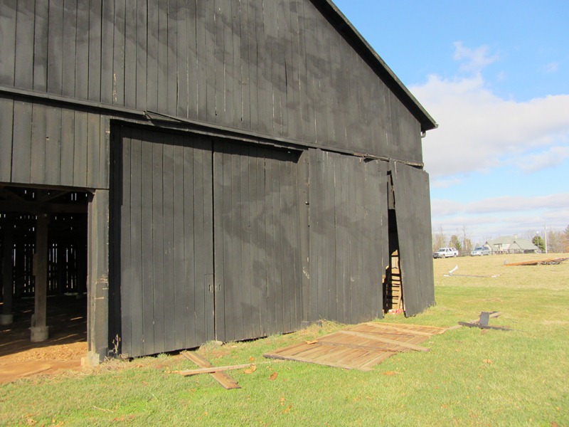
The images below are courtesy Mike Howard. The last two images are courtesy of Brandon Terry. Please click on an image for a larger version of each picture.
 |
 |
 |
 |
 |
 |
 |
 |
 |
 |
 |
 |
 |
 |
 |
 |
 |
 |
 |
 |
 |
 |
 |
 |
 |
 |
 |
 |
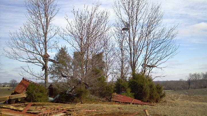
The images below are courtesy of Keith McBride.
 |
 |
 |
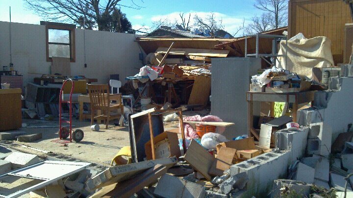
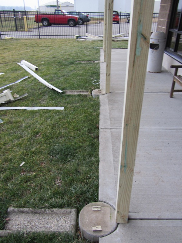
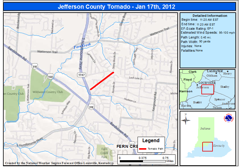
...EF-1 Tornado in Southeast Jefferson County Kentucky...
Start time: 11:20am EST
End Time: 11:20am EST
Wind speed: 100mph
Path length: 356 yards
Path width: 90 yards
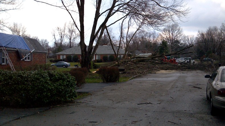
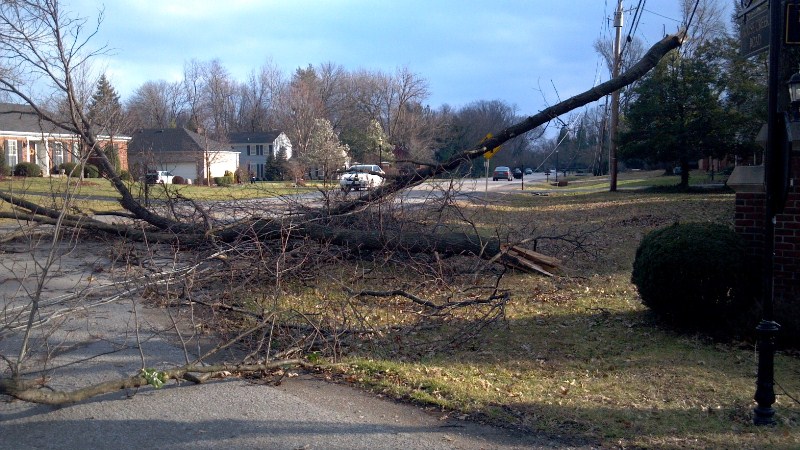
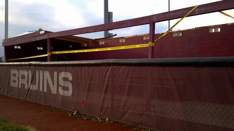
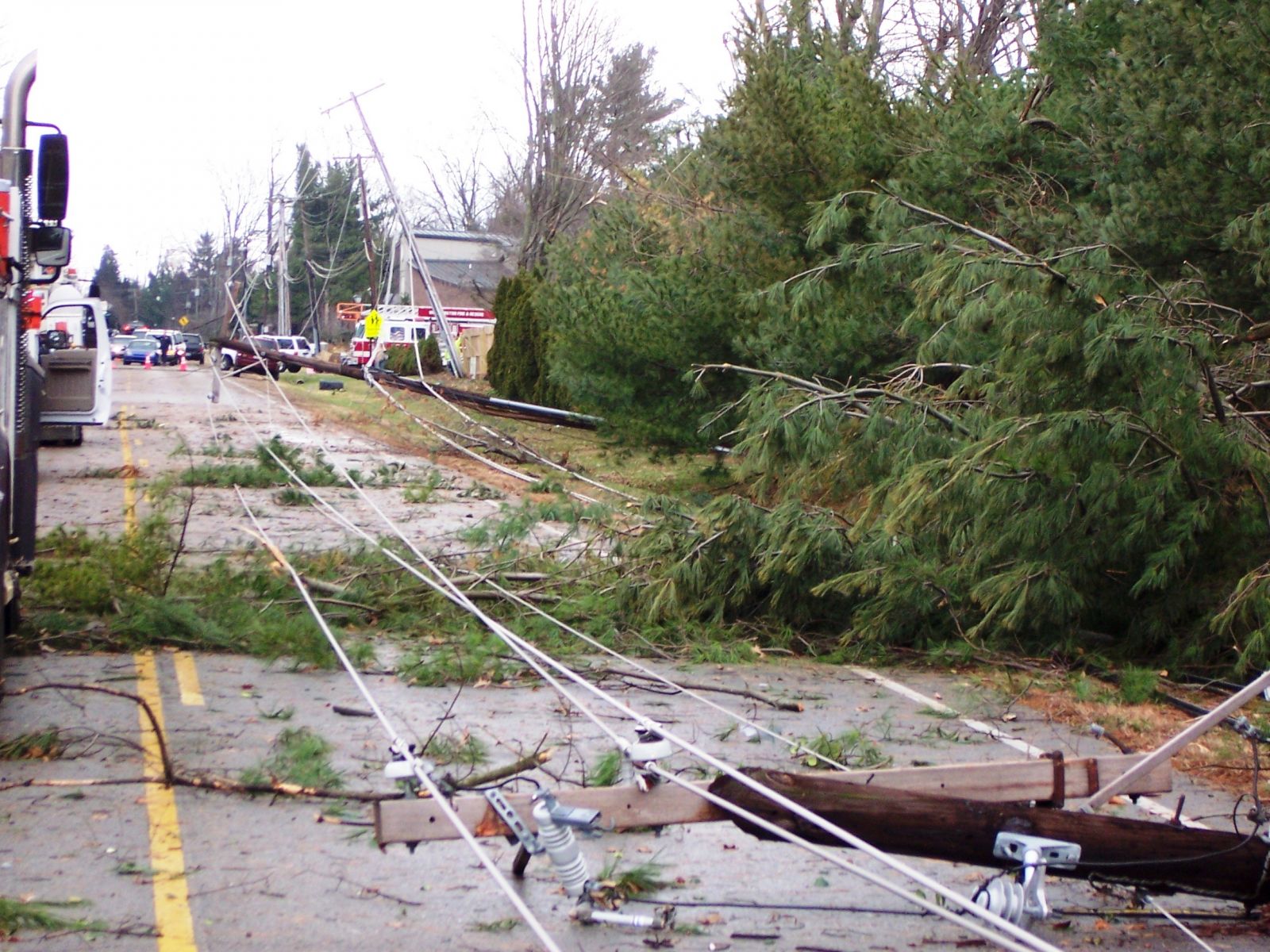
Narrative: An EF-1 tornado touched down just to the north of the intersection of Stony Brook Drive and Hurstbourne Parkway. The tornado traveled north-northeast along Stony Brook Drive and lifted near the intersection of Stony Brook and Laverne Drive. Numerous trees were snapped along the path. Siding and shingles were blown off of multiple houses. On Michael Edward Drive the garage door was blown in on a detached garage and the roof was lifted off and shifted a foot.
|
|
Below is a radar picture of both the ongoing tornado in northeast Jefferson County and the circulation aloft that would become the Fern Creek tornado shortly after this picture was taken:
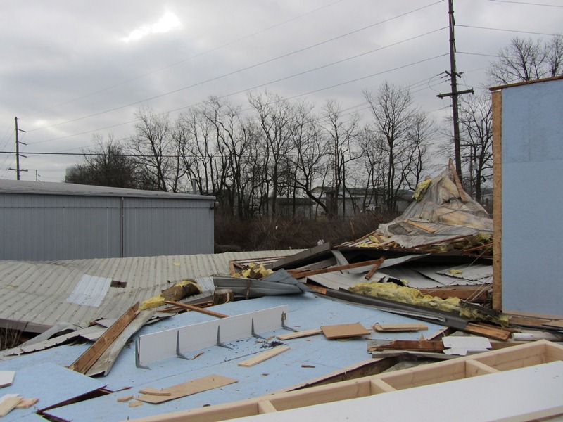
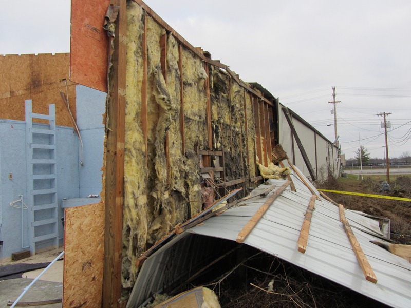
These photos were taken by the NWS storm survey team along the tornado path:
 |
 |
 |
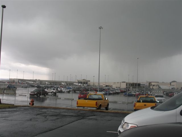
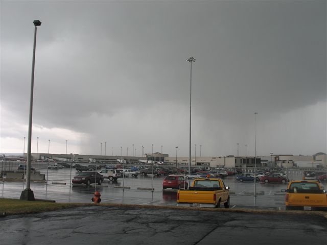
Here are some photos taken by Charles Henley at Louisville International Airport as the heavy rain was coming in from the west:
 |
 |
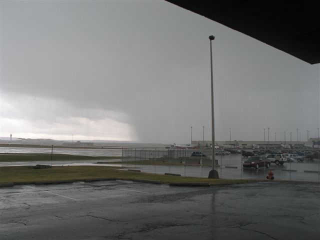 |
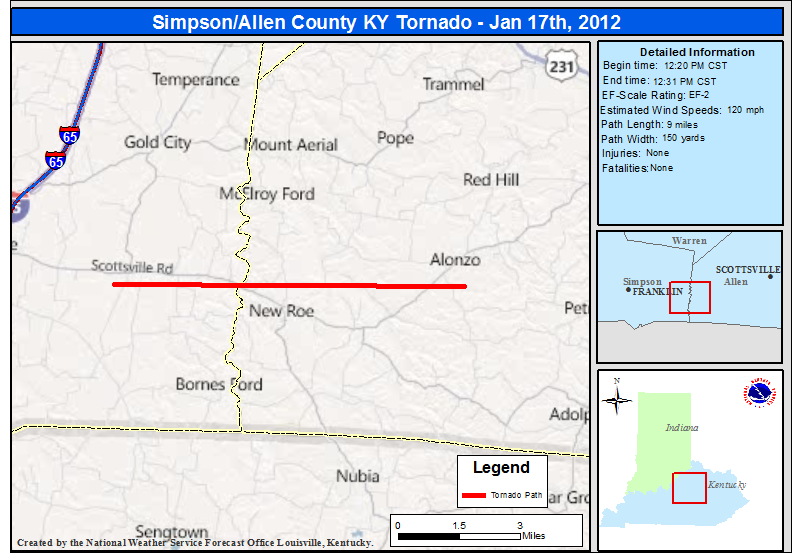
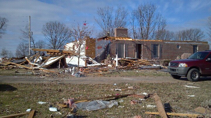
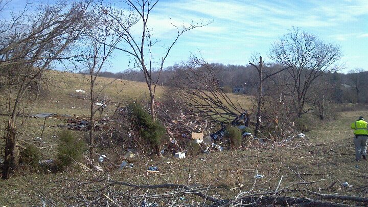
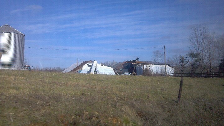
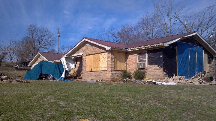
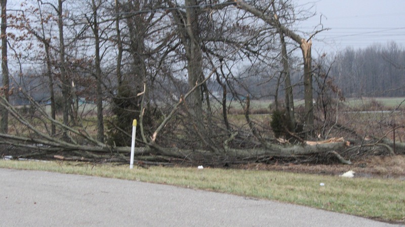
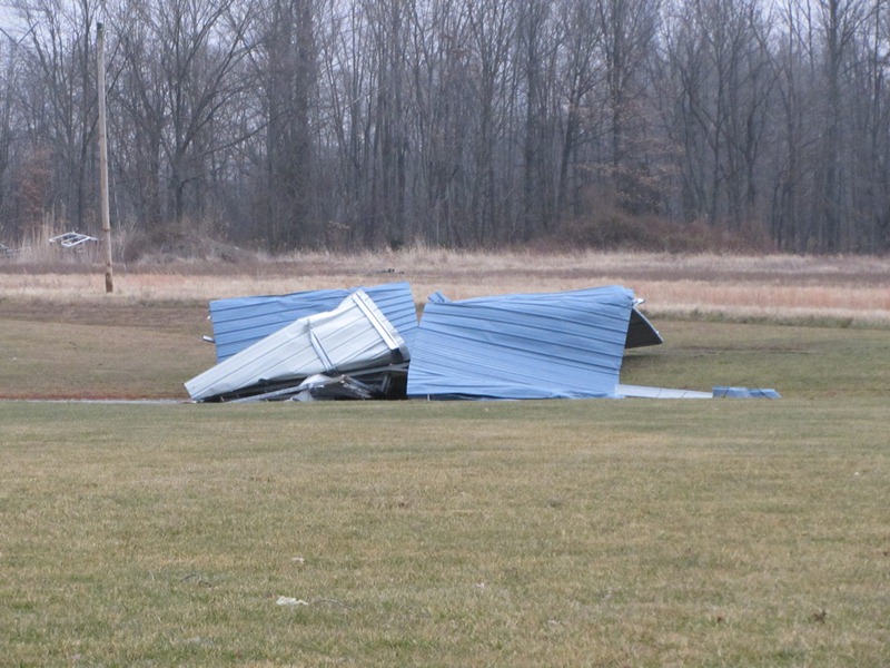
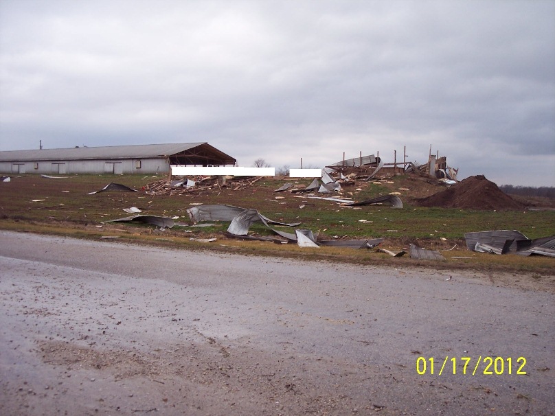
...EF-2 Tornado in Simpson and Allen Counties Kentucky...
Start time: 12:20pm CST
End time: 12:31pm CST
Wind speed: 120mph
Path length: 9 miles
Path width: 150 yards
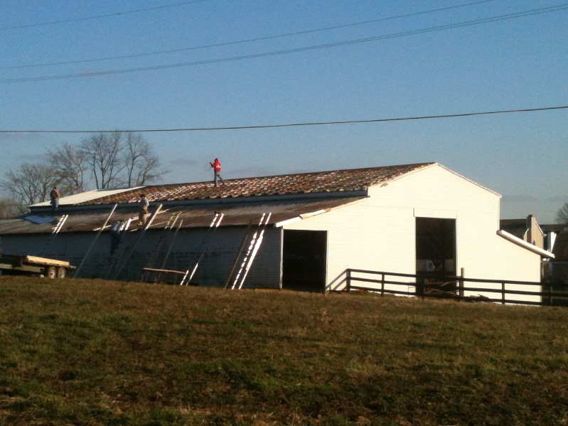
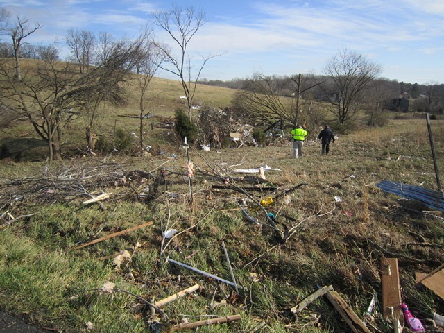
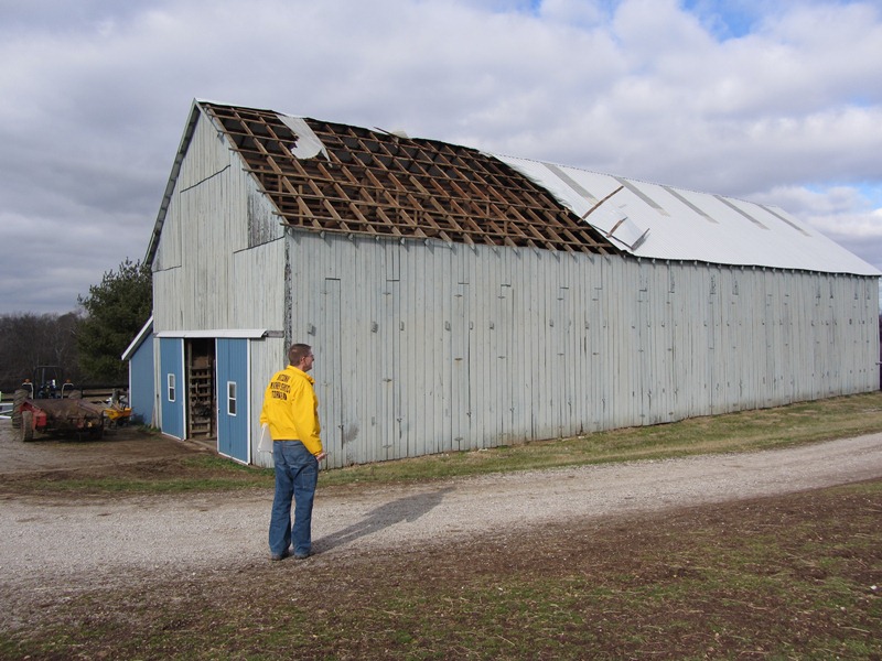
Narrative: This tornado touched down near Hickory Flat Road just south of its intersection with Hickory Flat-Ridge Road in Simpson County where about a dozen trees were uprooted. The most significant damage occurred near the intersection of McKendree Church Road and Highway 100 where a well constructed brick house completely lost its roof. Multiple barns, garages, and outbuildings were destroyed here as well. Nearly a complete roof of one outbuilding was project 1/2 mile to the east. Another area of significant damage was at the intersection of Highway 100 and Reeder School Road (near the Simpson/Allen County line) where a house had significant roof damage and had an exterior wall blown out. A jeep in the driveway was blown into the house and a camper was blown from the driveway across the road with debris scattered through the field beyond. Damage continued east into Allen County with the last evidence of damage at Walker Chapel Road about a mile south of Highway 100.
The Louisville NWS office is grateful to Tom Johnstone of the Nashville NWS office, who graciously agreed to survey this storm for us. Mr. Johnstone was accompanied by Evan Webb, a student at the Louisville office attending Western Kentucky University.
 |
Photos from Simpson County:
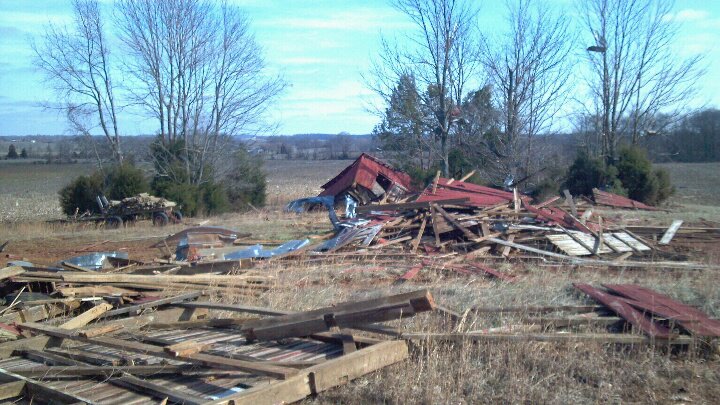 |
 |
 |
 |
 |
 |
 |
 |
 |
 |
 |
 |
 |
 |
 |
 |
 |
 |
 |
 |
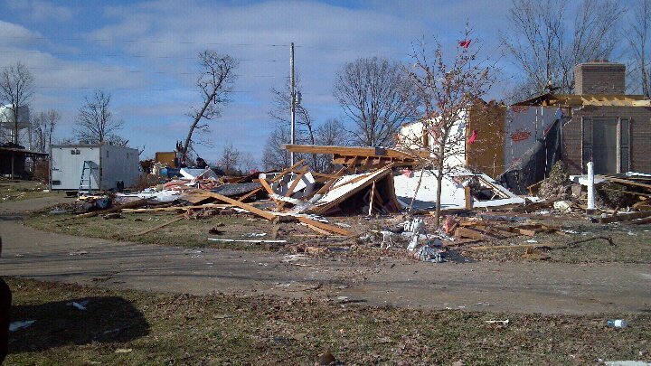
Photos from Allen County:
 |
 |
 |
 |
 |
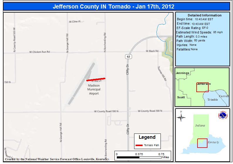
...EF-0 Tornado in Jefferson County Indiana...
Start Time: 10:40 AM EST
End Time: 10:40 AM EST
EF Scale: 0
Wind Speed: 85 MPH
Path Length: 0.3 Miles
Path Width: 60 Yards
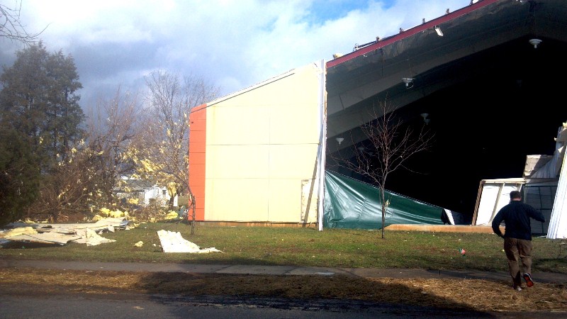
Narrative: An EF-0 tornado touched down at the Madison Municipal Airport. Damage was confined to IMS Lane. The tornado touched down briefly along this path and moved an at least 500 pound dumpster 35 feet southeast. It also moved a Beechcraft/King Air plane 10 degrees and the nose gear was broken. The airport operations building had a disabled awning and post. Part of a hangar`s siding came off with siding and insulation up in trees. Several trees were snapped along the narrow path. A witness saw the swirl as the tornado touched down.
 |
 |
 |
 |
 |
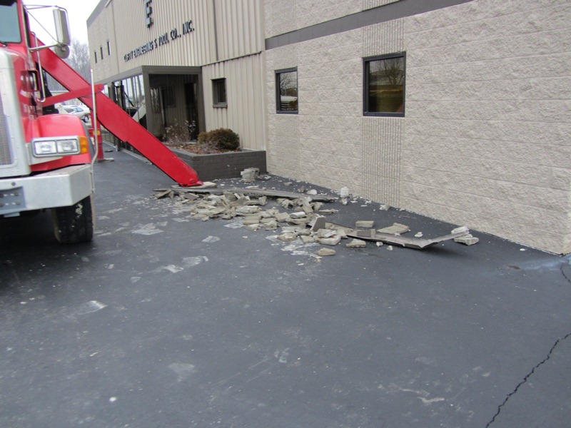
...Straight-Line Wind Damage in Jefferson County Indiana...
Start Time: 10:41 AM EST
End Time: 10:41 AM EST
Wind Speed: 90-95 MPH
Path Length: 150 Yards
Path Width: 75 Yards
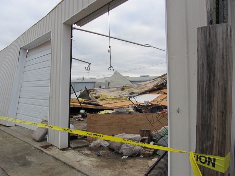
Narrative: Additional damage occurred east of the tornado damage at Madison Municipal Airport. First a nearby carport at a residence on Long Way was thrown across the road. Farther east, significant roof damage occurred at the main building at Clifty Engineering and Tool in the 2900 block of Clifty Dr, just west of Clifty Falls State Park. There was significant roof damage to the top of the main building and to a large storage building just behind it. All of the damage was directed to the east, including a tree that was down.
 |
 |
 |
 |
 |
 |
 |
 |
 |
 |
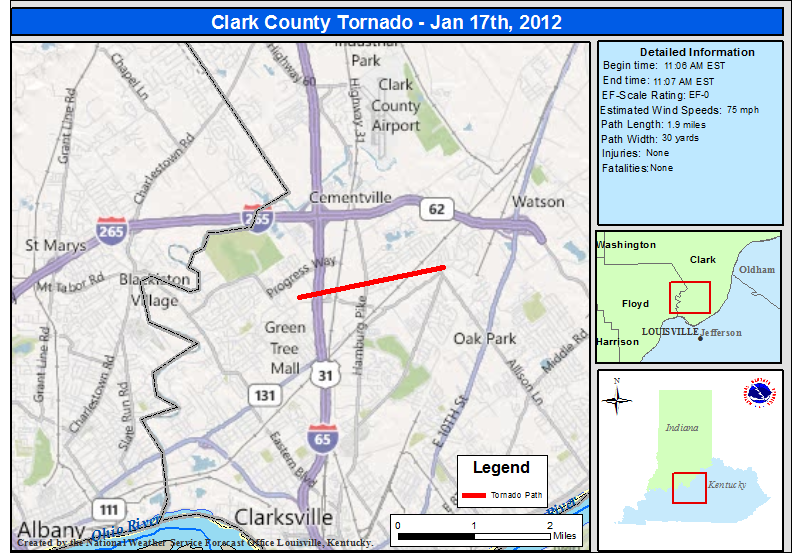
...EF-0 Tornado in Clark County Indiana...
Start Time: 11:06 AM EST
End Time: 11:07 AM EST
Wind Speed: 75 MPH
Path Length: 1.9 Miles
Path Width: 30 Yards
Narrative: An EF-0 tornado first touched down at the Wal-Mart parking lot on the northwest corner of the Veteran`s Parkway near I-65. A vehicle was turned over on I-65, then the tornado skipped over an area before coming down again on a subdivision to the east, with damage occurring along Belmar Dr and Meadows Dr as well as at the intersection of Kingsfield St and Crown Ct. It took down several fences, with evidence of cyclonic circulation. It lifted again before coming down and taking the roof of a barn on Armstrong Rd.,
where the tornado ended.
 |
 |
The radar picture below shows three areas of interest. From north to south, first there is the circulation that just produced the Clark County tornado a couple of minutes earlier. Next, we see the strong circulation that would produce the northeast Jefferson County tornado a couple of minutes later. Finally, over Louisville International Airport we see the beginnings of a circulation that will go on to produce the Fern Creek tornado
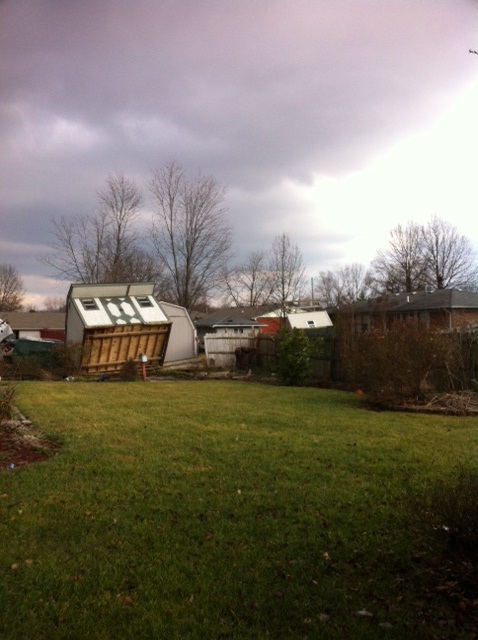
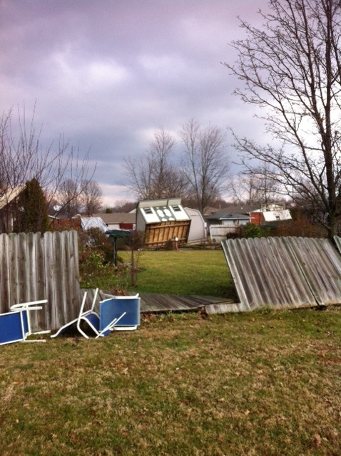
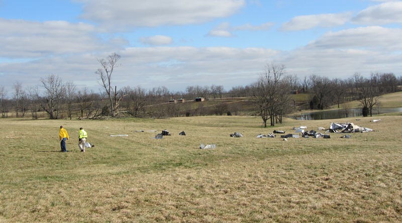
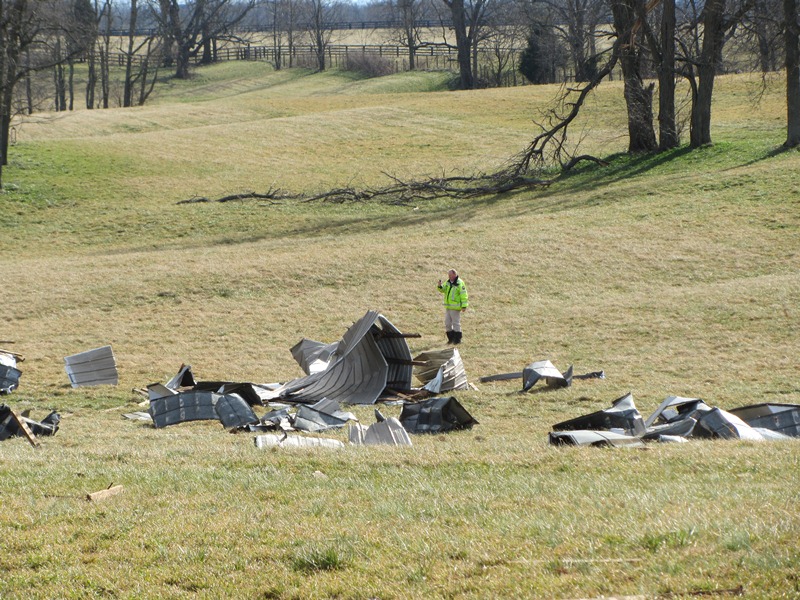
Here are a couple of photos taken by the NWS storm survey team:
 |
 |
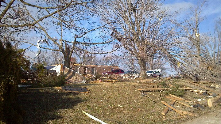
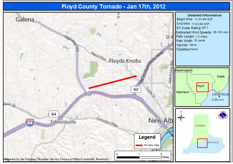
...EF-1 Tornado in Floyd County Indiana...
Start Time: 11:00 AM EST
End Time: 11:02 AM EST
EF Scale: 1
Wind Speed: 95-100 MPH
Path Length: 1.2 Miles
Path Width: 50 Yards
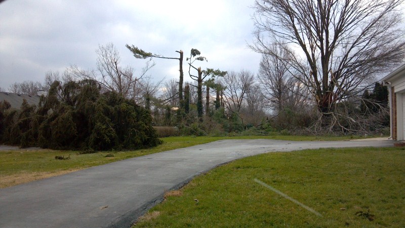
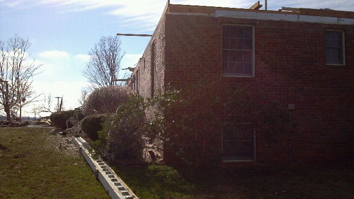
Narrative: EF-1 tornado first touched down on East Riley Rd. in CountyFloyds Knobs, where a garage was destroyed. The tornado continued east across the Knobs toward Binford Rd, where it took multiple trees down. The tornado crossed Paoli Pike just north of I-265 and caused roof damage at the Knob Point Apartments.
 |
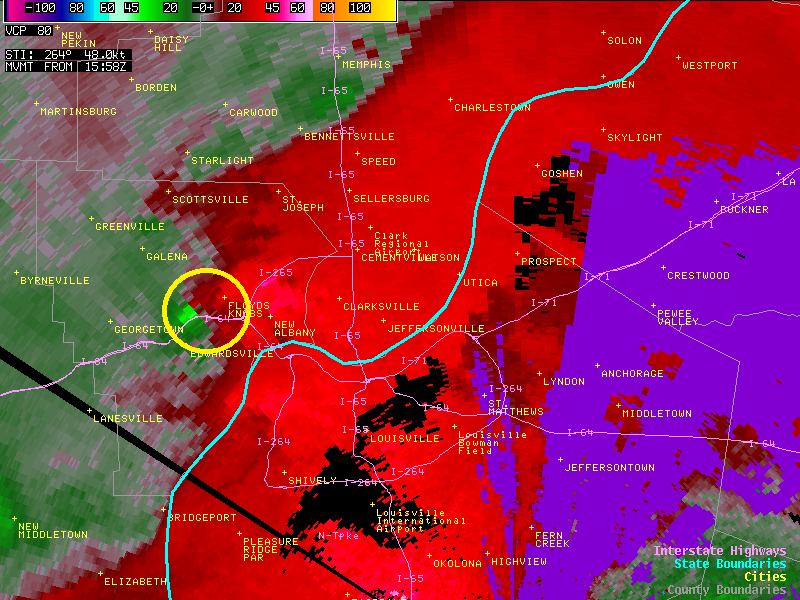
Here's a radar picture showing the circulation that produced the tornado:
A few photos from the NWS storm survey team:
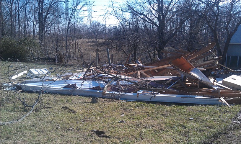 |
 |
 |
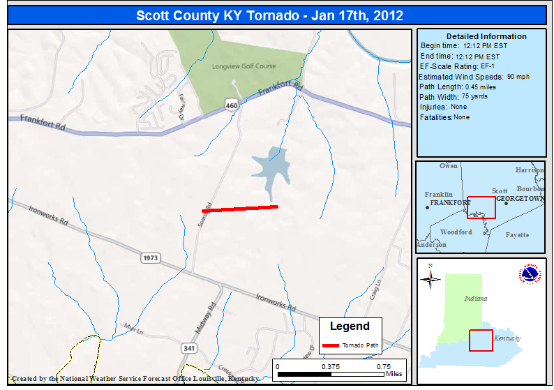
...EF-1 Tornado in Scott County Kentucky...
Start Time: 12:12pm EST
End Time: 12:12pm EST
EF Scale: 1
Wind speed: 90mph
Path length: 0.45 mile
Path width: 75 yards
Narrative: This tornado touched down at 338 Soards Road and moved northeast, lifting as it began to cross a small lake. A well-anchored 50x20 three bay barn was destroyed and scattered in three directions. A 20x30 barn was also destroyed, and a third small barn along the path was damaged. Numerous trees were blown down, snapped, or uprooted. Fences were torn down as well. This survey was conducted by personnel from both the NWS and emergency management from Franklin and Scott Counties.
 |
These photos were taken by the official National Weather Service storm survey team, in conjunction with Scott County Emergency Management. Please click on an image to see a larger version.
 |
 |
 |
 |
 |
 |
 |
 |
 |
 |
 |
 |
 |
 |
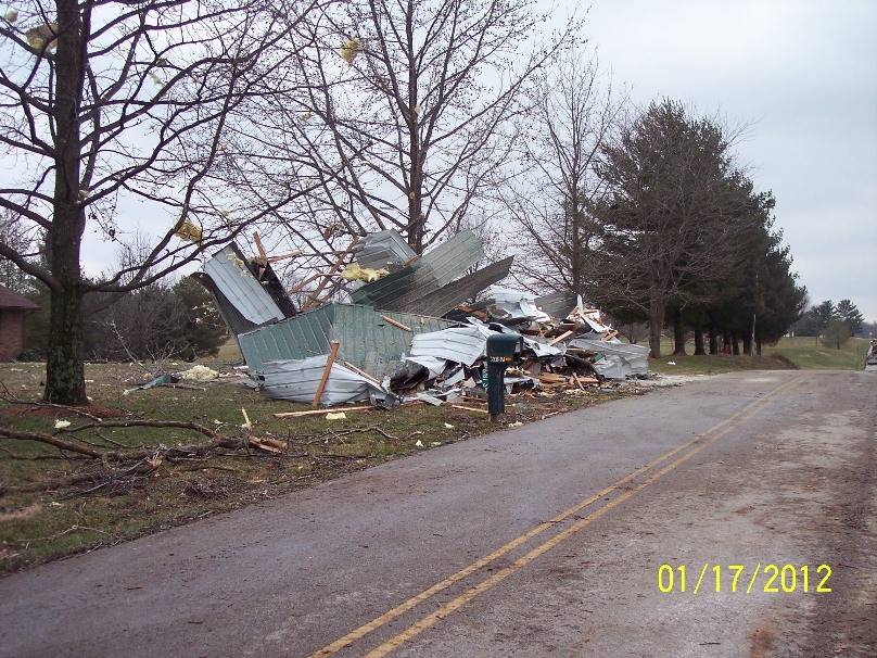
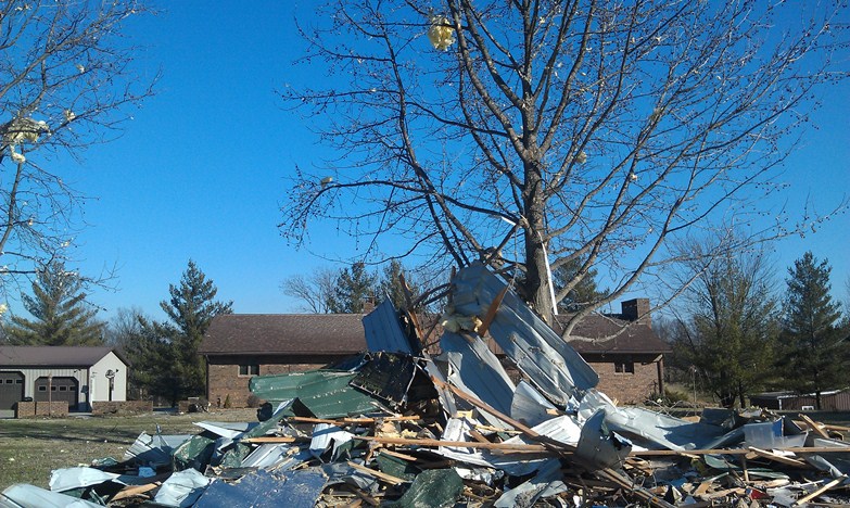
...2 Tornadoes in DuBois County...
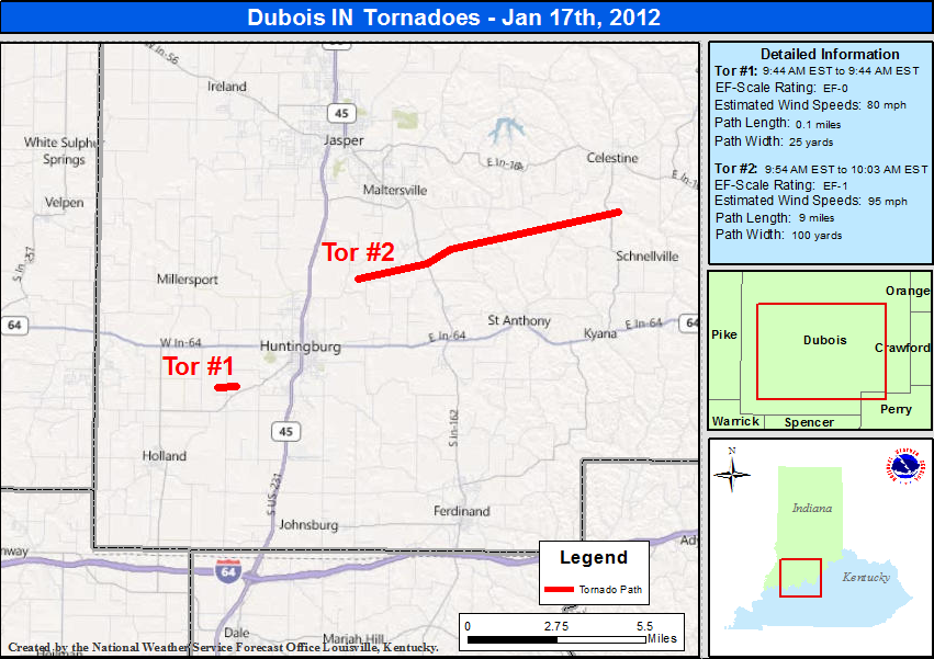
Start Time: 9:44am EST
End Time: 9:44am EST
Wind speed: 80 mph
Path length: 0.1 mile
Path width: 25 yards
Narrative: Touched down 2.7 miles southwest of Huntingburg. An outbuilding was destroyed and debris was scattered for a quarter mile.
NWS storm survey team photos:
 |
 |
 |
Start Time: 9:54am EST
End Time: 10:03am EST
Wind speed: 95mph
Path length: 9 miles
Path width: 100 yards
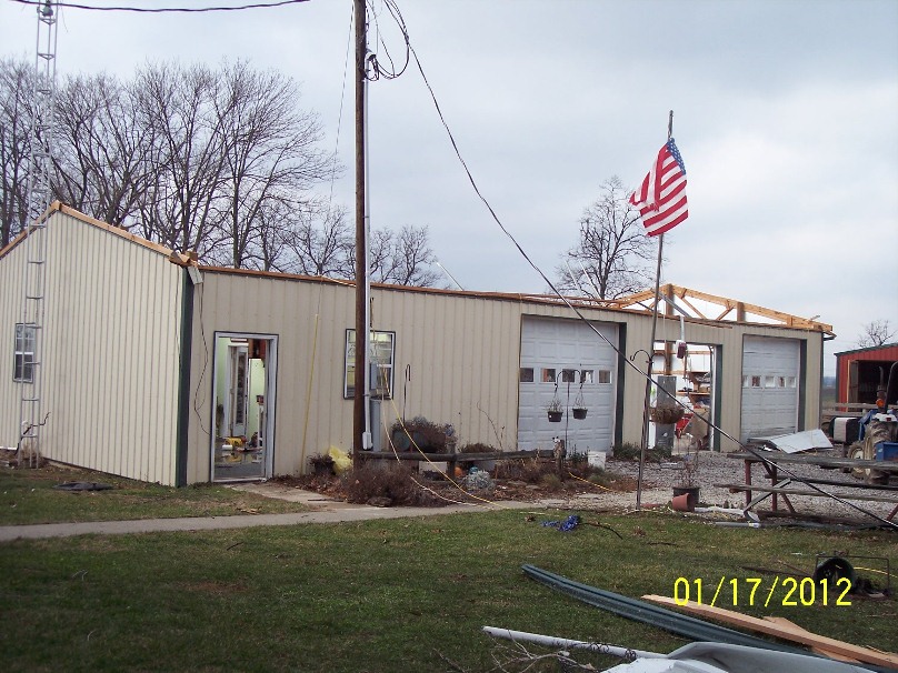
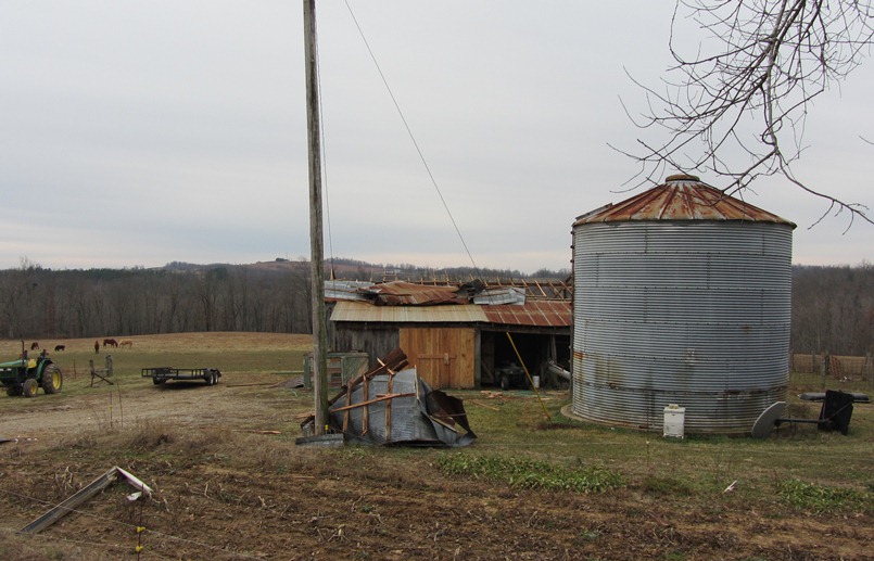
Narrative: This tornado touched down three miles northeast of Huntingburg, destroying a barn and blowing several outbuildings off their foundation. The tornado skipped east-northeast for nearly 9 miles across primarily open fields. Structural damage occurred along IN-162 where over 50 feet of a 600 foot long commercial outbuilding was destroyed. One-half mile east of IN-162, numerous outbuildings were damaged and a small grain hopper was toppled. Continuing east-northeast, a roof was blown off of one barn and another barn had roof sections peeled off on St. Anthony Road West. Occasional uprooted and snapped trees occurred for an additional 5 miles before the tornado dissipated after destroying a 40 by 50 foot tool shed 1.6 miles south-southeast of Celestine.
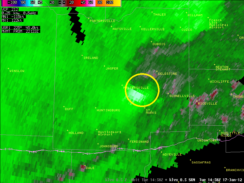
A radar picture taken as the EF-1 tornado was moving across Dubois County:
Photos of tornado damage from the NWS storm survey team and Dubois County Emergency Management:
 |
 |
Here's a photo of straight-line wind damage near the touchdown of the tornado:
...Straight-Line Wind Damage in Franklin County and Scott County, Kentucky...
Start time: 11:59am EST
End time: 11:59am EST
Wind speed: 65mph
Narrative: Near the intersection of Highways 421 and 60 on Leestown Road in Franklin County a power pole was blown down near a Toyota dealership. Also, at a storage unit facility, the roof was removed from three of the units and blown downwind. The doors of the units were open. In Scott County at the intersection of Muir Lane and Midway Lane a 60 by 40 horse barn's roof was blown downwind, trees were blown down, and shingles were torn off of a house along a 200 yard path.
Here are some photos taken in Frankfort by the NWS Storm Survey Team:
 |
 |
 |
 |
 |
Some more photos from the survey in Franklin County, this time along Muir Lane:
 |
 |
 |
 |
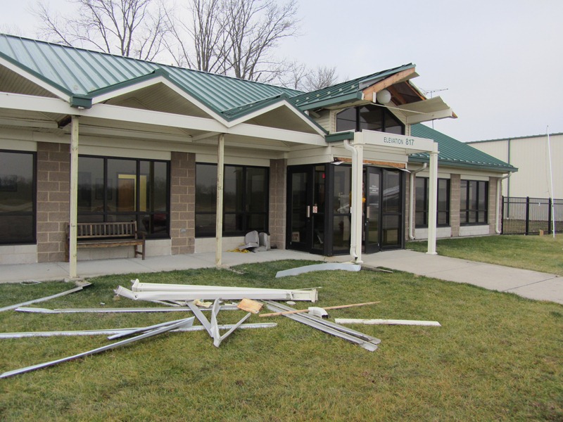
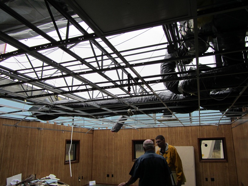
...Straight-Line Wind Damage in Scott County, Kentucky...
Start time: 12:13pm EST
End time: 12:13pm EST
Wind speed: 60mph
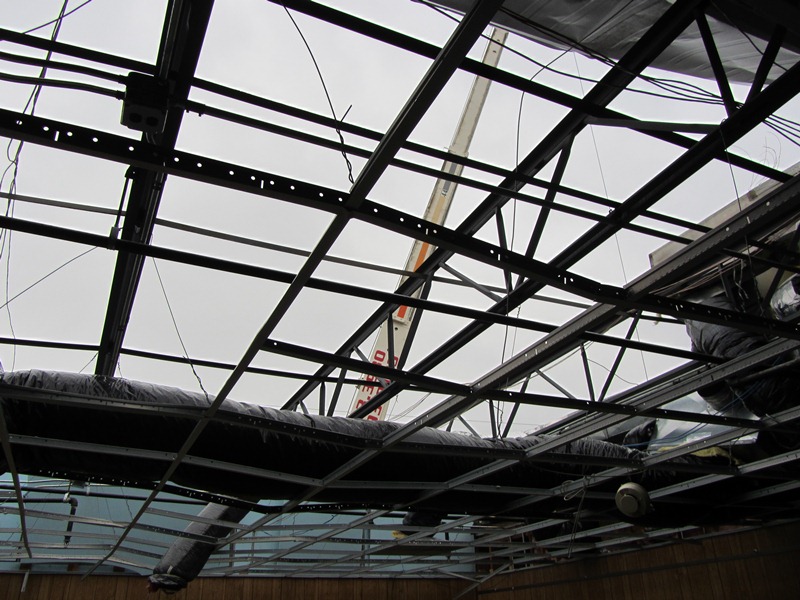
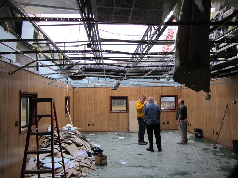
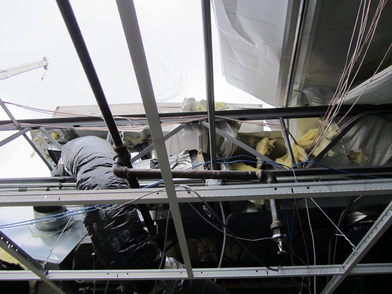
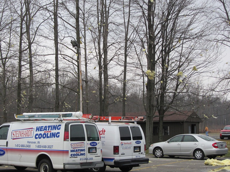
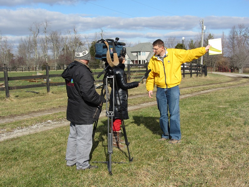
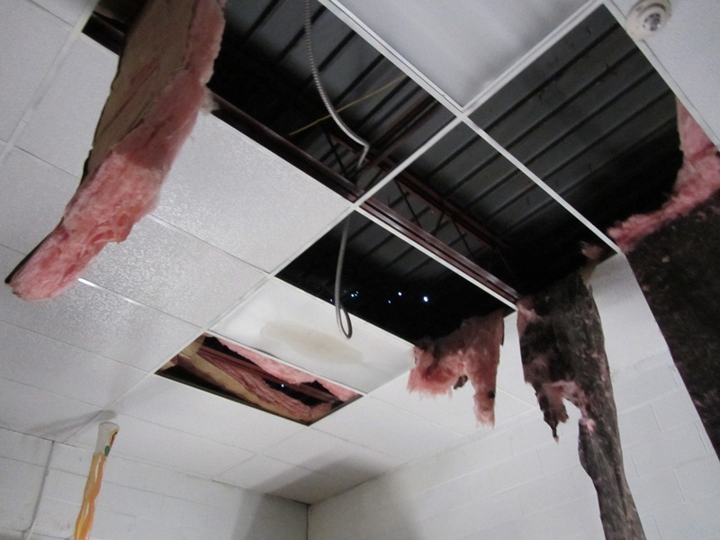
Narrative: In Georgetown 60mph winds blew the roof of of a community center at 221 Oregon Road. This survey was conducted by personnel from both the NWS and emergency management from Scott County. Below is a photo of the ceiling inside the center, as well as a shot of the Louisville weather office's Meteorologist-in-Charge speaking with local media at the site.
 |
 |
...Straight-Line Wind Damage in Breckinridge County...
Start time: 10:25am CST
End time: 10:25am CST
Wind speed: 65mph
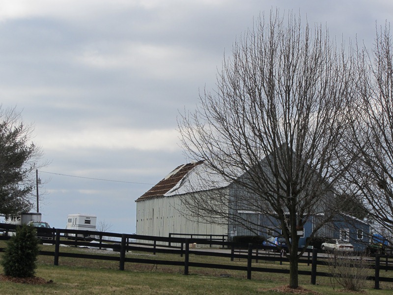
Narrative: Strong winds five miles south-southwest of Harned removed the roof from an old barn and threw it onto a nearby house, damaging the home's roof.
Photos from the NWS storm survey team:
 |
 |
 |
 |
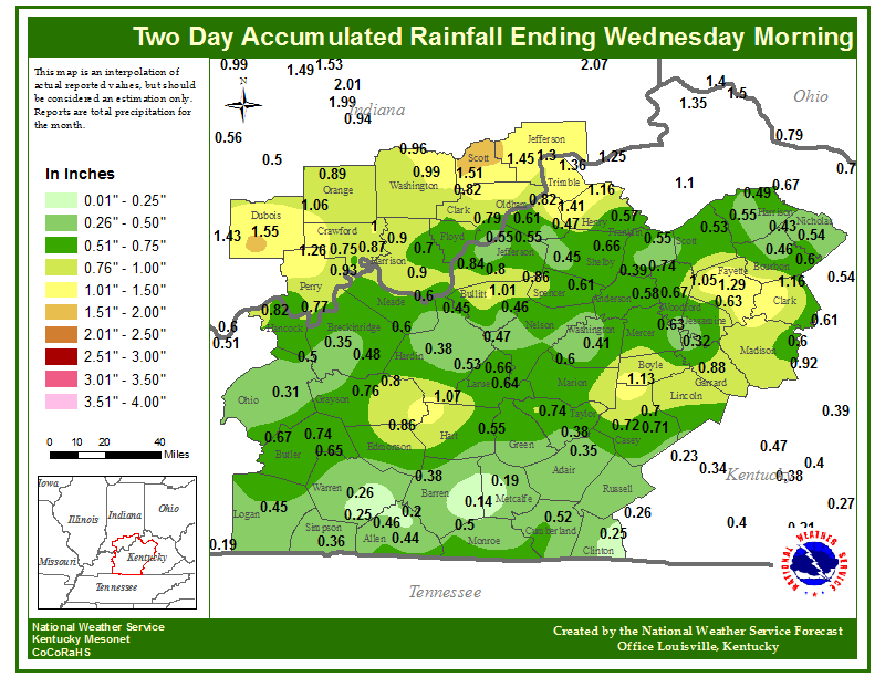
...Rainfall during the event...
...Text Listing of Storm Reports...
..TIME... ...EVENT... ...CITY LOCATION... ...LAT.LON...
..DATE... ....MAG.... ..COUNTY LOCATION..ST.. ...SOURCE....
..REMARKS..
0944 AM TORNADO 3 SW HUNTINGBURG 38.27N 86.99W
01/17/2012 DUBOIS IN NWS STORM SURVEY
EF-0 TORNADO...ESTIMATED WINDS 80 MPH...PATH LENGTH 0.1
MILES...WIDTH 25 YDS...OUTBUILDING DESTROYED AND DEBRIS
SCATTERED FOR A QUARTER MILE.
0954 AM TORNADO 3 NE HUNTINGBURG 38.33N 86.92W
01/17/2012 DUBOIS IN NWS STORM SURVEY
EF-1 TORNADO...ESTIMATED WINDS 95 MPH...PATH LENGTH 9
MI...WIDTH 100 YDS...NUMEROUS OUTBUILDINGS DAMAGED AND
SMALL GRAIN HOPPER TOPPLED. DOZENS OF TREES DOWNED. ROOF
DAMAGE OFF OF ST ANTHONY ROAD WEST. TOOL SHED DESTROYED
SSE OF CELESTINE.
1003 AM NON-TSTM WND DMG LOUISVILLE 38.22N 85.74W
01/17/2012 JEFFERSON KY PUBLIC
CAR WINDSHIELDS DAMAGED NEAR FAIRGROUNDS.
1021 AM TSTM WND DMG 3 NE HOLLAND 38.28N 87.00W
01/17/2012 DUBOIS IN EMERGENCY MNGR
OUTBUILDING BLOWN ON ROAD.
1026 AM TSTM WND DMG 1 N HUNTINGBURG 38.31N 86.96W
01/17/2012 DUBOIS IN PUBLIC
NUMEROUS TREE LIMBS DOWN.
1026 AM TSTM WND DMG 2 N HUNTINGBURG 38.33N 86.96W
01/17/2012 DUBOIS IN NEWSPAPER
SEMI TRUCK OVERTURNED ON U.S. 231 JUST NORTH OF PHOENIX
DRIVE DUE TO STRONG WINDS
1032 AM FUNNEL CLOUD 1 SE CURBY 38.23N 86.37W
01/17/2012 CRAWFORD IN TRAINED SPOTTER
SPOTTER SEES RAIN WRAPPED FUNNEL.
1040 AM TSTM WND DMG 1 E MADISON 38.76N 85.45W
01/17/2012 JEFFERSON IN NWS EMPLOYEE
REPORT RELAYED FROM JKL NWS. ROOF TAKEN OFF BLDG. BARK
OFF TELEPHONE POLES. DOOR TO GARAGE RIPPED OFF AN THROWN
AROUND METAL POLE. DAMAGE LOCATED A MILE OR TWO WEST OF
CLIFTY FALLS STATE PARKS NORTH ENTRANCE.
1040 AM TORNADO MADISON 38.76N 85.46W
01/17/2012 JEFFERSON IN NWS STORM SURVEY
EF-0 TORNADO TOUCHED DOWN AT MADISON MUNICIPAL AIRPORT.
DAMAGE WAS CONFINED TO IMS LN. THE DAMAGE PATH WAS 0.3
MILES LONG AND 60 YARDS WIDE. A LARGE DUMPSTER WAS MOVED
35 FEET AND AN AIRPLANE WAS SHIFTED. PART OF A HANGARS
SIDING CAME OFF ALONG WITH A DISABLED AWNING AND POST AT
THE AIRPORT OPERATIONS BUILDING. SEVERAL TREES WERE
SNAPPED ALONG THE NARROW PATH.
1049 AM TSTM WND DMG MADISON 38.76N 85.38W
01/17/2012 JEFFERSON IN PUBLIC
DAMAGE TO BUILDING AT AIRPORT
1049 AM TSTM WND DMG 2 N MADISON 38.78N 85.38W
01/17/2012 JEFFERSON IN EMERGENCY MNGR
MAJOR BUILDING DAMAGE...ONE BUILDING LOST ROOF ON IN
62. POWER LINES AND TREES DOWN. WIND DAMAGE A MILE WIDE
NEAR AIRPORT.
1100 AM TORNADO FLOYDS KNOBS 38.31N 85.87W
01/17/2012 FLOYD IN NWS STORM SURVEY
EF-1 TORNADO TOUCHED DOWN ON EAST RILEY RD IN FLOYDS
KNOBS AND DESTROYED A GARAGE. THE TORNADO CONTINUED EAST
ALONG BINFORD ROAD WHERE MULTIPLE TREES WERE DOWN. THE
TORNADO CONTINUED EAST ACROSS PAOLI PIKE AND CAUSED ROOF
DAMAGE AT KNOB POINT APARTMENTS BEFORE LIFTING.
1105 AM TSTM WND GST PLEASURE RIDGE PARK 38.15N 85.85W
01/17/2012 E60 MPH JEFFERSON KY TRAINED SPOTTER
1106 AM TORNADO 1 NNE CLARKSVILLE 38.33N 85.76W
01/17/2012 CLARK IN NWS STORM SURVEY
EF-0 TORNADO FIRST TOUCHED DOWN AT THE WAL-MART PARKING
LOT AT VETERANS PARKWAY NEAR I-65. A VEHICLE WAS TURNED
OVER ON I-65. THE TORNADO SKIPPED TO A SUBDIVISION EAST
OF THERE CAUSING DAMAGE ALONG BELMAR AND MEADOWS DR AS
WELL AS AT THE INTERSECTION OF KINGSFIELD ST AND CROWN
CT. IT TOOK DOWN SEVERAL FENCES AND THEN LATER THE ROOF
OF A BARN ON ARMSTRONG RD... WHERE THE TORNADO ENDED.
1107 AM TSTM WND DMG 2 SSW LOUISVILLE 38.20N 85.75W
01/17/2012 JEFFERSON KY TRAINED SPOTTER
4 LARGE UTILITY POLES BROKEN ON DAKOTA AVE AND FLOYD
ST.
1107 AM TSTM WND DMG CLOVERPORT 37.83N 86.63W
01/17/2012 BRECKINRIDGE KY DEPT OF HIGHWAYS
SEVERAL TREES DOWN NEAR CLOVERPORT
1110 AM TSTM WND DMG 2 N ST. MATTHEWS 38.28N 85.64W
01/17/2012 JEFFERSON KY PUBLIC
TWITTER REPORT OF POWER LINES DOWN AT WATTERSON AND
BROWNSBORO RD.
1112 AM TORNADO 2 N ST. MATTHEWS 38.28N 85.64W
01/17/2012 JEFFERSON KY NWS STORM SURVEY
*** 1 INJ *** EF-1 TORNADO WITH WIND SPEED ESTIMATED AT
95 MPH. PATH LENGTH WAS 5.7 MILES AND PATH WIDTH WAS 250
YARDS. THE TORNADO TOUCHED DOWN NEAR INTERSECTION OF
I-264 AND BROWNSBORO ROAD AND TRACKED NORTHEAST TO NEAR
THE INTERSECTION OF HURSTBOURNE AND BROWNSBORO WHERE IT
LIFTED BRIEFLY. IT THEN REFORMED AND CROSSED I-265 AND
CONTINUED EAST NORTHEAST INTO A COUPLE OF SUBDIVISIONS.
IT LIFTED JUST NORTHEAST OF A HORSE BARN NEAR MURPHY LN.
1115 AM TSTM WND DMG LOUISVILLE 38.22N 85.74W
01/17/2012 JEFFERSON KY PUBLIC
AIR CONDITIONING UNIT BLOWN OFF DOWNTOWN HOTEL.
1115 AM TSTM WND DMG 3 NNW ANCHORAGE 38.31N 85.57W
01/17/2012 JEFFERSON KY PUBLIC
BROADCAST MEDIA RELAYED REPORT OF ONE POSSIBLY TWO
SEMIS OVERTURNED NEAR BROWNSBORO EXIT ON SNYDER.
1115 AM TSTM WND DMG 3 SSE PROSPECT 38.31N 85.58W
01/17/2012 JEFFERSON KY TRAINED SPOTTER
TREES DOWN ONE ON TOP OF TRUCK IN VICINITY OF GOOSE
CREEK AND HWY 22. SIDE OF HOUSE BLOWN OFF ALONG BAY
WINDOW AND SHINGLE DAMAGE.
1115 AM TSTM WND DMG 3 SSE PROSPECT 38.31N 85.58W
01/17/2012 JEFFERSON KY COUNTY OFFICIAL
HURSTBOURNE AND BROWNSBORO RD HWY 22 IMPASSABLE DUE TO
TREES DOWN. REPORT RELAYED VIA METROSAFE.
1115 AM TSTM WND DMG 2 N LYNDON 38.30N 85.59W
01/17/2012 JEFFERSON KY COUNTY OFFICIAL
TREE FELL ON HOUSE IN THE 3600 BLOCK OF REMS RD
1119 AM TSTM WND DMG 1 NNW FERN CREEK 38.17N 85.60W
01/17/2012 JEFFERSON KY NWS EMPLOYEE
SEVERAL TREES DOWN AND SEVERAL SNAPPED ALONG WITH
SHINGLES BLOWN OFF HOUSES ON STONEY BROOK DR NEAR
MICHAEL EDWARDS DR. A TREE WAS TOPPED NEAR ROMAN CT. THE
ROOF OF ONE HOUSE WAS SHIFTED 4-6 INCHES. SOME SIDING
TAKEN OFF OF HOUSES AS WELL.
1119 AM TSTM WND DMG 2 WNW PEWEE VALLEY 38.32N 85.52W
01/17/2012 OLDHAM KY NWS STORM SURVEY
ADDITIONAL ISOLATED WIND DAMAGE OCCURRED IN THE WINDY
WILLOW AND ORCHARD GRASS HILLS SUBDIVISION. SEVERAL
TREES WERE UPROOTED OR SNAPPED CLOSE TO THE GROUND ALONG
WITH MINOR SIDING AND ROOF ISSUES ON AREA HOUSES.
1120 AM TORNADO 1 NNW FERN CREEK 38.17N 85.60W
01/17/2012 JEFFERSON KY NWS STORM SURVEY
AN NWS STORM SURVEY CONFIRMED AN EF-1 TORNADO WITH
WINDS OF 95-100 MPH TOUCHED DOWN JUST TO THE NORTH OF
THE INTERSECTION OF STONY BROOK DR AND HURSTBOURNE PKWY.
THE TORNADO TRAVELED TO THE NNE FOR 0.45 MILES AND
LIFTED NEAR THE INTERSECTION OF LAVERNE DR AND STONY
BROOK. THE PATH WIDTH WAS 90 YARDS. NUMEROUS TREES WERE
SNAPPED AND UPROOTED. SIDING AND SHINGLES WERE BLOWN OFF
HOUSES. A GARAGE HAD ITS DOOR BLOWN IN AND ITS ROOF
LIFTED AND SHIFTED ONE FOOT.
1121 AM TSTM WND DMG 3 N JEFFERSONVILLE 38.34N 85.73W
01/17/2012 CLARK IN PUBLIC
OUTBUILDINGS ON FARM BLOWN OVER... HOME UNDER
CONTRUCTION DESTROYED NEAR CORNER OF HOLMANS LANE AND
VETERANS PARKWAY.
1121 AM TSTM WND DMG HARDINSBURG 37.78N 86.45W
01/17/2012 BRECKINRIDGE KY EMERGENCY MNGR
A FEW SHINGLES BLOWN OFF A HOUSE IN HARDINSBURG
1123 AM TSTM WND DMG 4 N JEFFERSONVILLE 38.36N 85.73W
01/17/2012 CLARK IN LAW ENFORCEMENT
TORNADO SEEN CROSSING I-65 NEAR 4 MILE MARKER. SIGNS
AND VECHICLES DAMAGED. LARGE DUMPSTER MOVED.
1123 AM TSTM WND DMG MCQUADY 37.70N 86.52W
01/17/2012 BRECKINRIDGE KY DEPT OF HIGHWAYS
CATTLE TRAILER TURNED OVER NEAR MCQUADY
1125 AM HAIL 2 W FORDSVILLE 37.64N 86.75W
01/17/2012 M0.50 INCH OHIO KY TRAINED SPOTTER
1125 AM TSTM WND DMG 4 N JEFFERSONVILLE 38.36N 85.73W
01/17/2012 CLARK IN EMERGENCY MNGR
SECTIONS OF ROOF REMOVED FROM HOMES IN THE MEADOWS
SUBDIVISION OFF OF HAMBURG PIKE AND ARMSTRONG FARMS
SUBDIVSION OFF OF VETERANS PARKWAY.
1125 AM TSTM WND DMG 2 W BALLARDSVILLE 38.37N 85.39W
01/17/2012 OLDHAM KY TRAINED SPOTTER
TREE UPROOTED ON FOX TRAIL COURT.
1128 AM TSTM WND DMG ANCHORAGE 38.27N 85.54W
01/17/2012 JEFFERSON KY NWS EMPLOYEE
12 INCH DIAMETER TREE DOWN NEAR WESTPORT ROAD AND
I-265.
1130 AM TSTM WND DMG 3 NNW CHESTNUT GROVE 38.34N 85.28W
01/17/2012 SHELBY KY PUBLIC
BARN SPLIT. SEVERAL TREES TWISTED. PART OF A SILO
MISSING AT A FARM ALONG HWY 53 IN NORTH SHELBY COUNTY.
1132 AM TSTM WND DMG HARNED 37.75N 86.42W
01/17/2012 BRECKINRIDGE KY PUBLIC
TREES DOWN
1135 AM TSTM WND DMG ROFF 37.65N 86.43W
01/17/2012 BRECKINRIDGE KY DEPT OF HIGHWAYS
SEVERAL TREES DOWN NEAR ROFF
1142 AM TSTM WND DMG MCDANIELS 37.60N 86.43W
01/17/2012 BRECKINRIDGE KY CO-OP OBSERVER
6 INCH LIMBS BLOWN OFF.
1152 AM TSTM WND DMG LOUISVILLE 38.22N 85.74W
01/17/2012 JEFFERSON KY NWS EMPLOYEE
TREE UPROOTED AT ZORN AVE AND RIVER ROAD.
1158 AM TSTM WND DMG 3 ESE FRANKFORT 38.17N 84.81W
01/17/2012 FRANKLIN KY TRAINED SPOTTER
A TRAINED SPOTTER REPORTED A SHOP WAS DESTROYED ON
LEESTOWN ROAD.
1159 AM TSTM WND DMG 2 SSW FORKS OF ELKHORN 38.19N 84.82W
01/17/2012 FRANKLIN KY NWS STORM SURVEY
ESTIMATED 65MPH WINDS. POWER POLE BLOWN DOWN BEHIND
TOYOTA DEALERSHIP NEAR INTERSECTION OF HIGHWAYS 421 AND
60. ROOFS REMOVED FROM SEVERAL STORAGE UNITS.
1200 PM TSTM WND DMG 2 SSW FORKS OF ELKHORN 38.19N 84.81W
01/17/2012 FRANKLIN KY BROADCAST MEDIA
ROOF BLOWN OFF STORAGE FACILITY ON LEESTOWN ROAD.
1205 PM TSTM WND DMG 2 SE HIGHGROVE 37.95N 85.45W
01/17/2012 NELSON KY TRAINED SPOTTER
LOST SOME SHINGLES OFF ROOF AND 8 INCH DIAMETER TREE
DOWN.
1210 PM TSTM WND DMG 3 NNE MIDWAY 38.18N 84.67W
01/17/2012 SCOTT KY NWS STORM SURVEY
60 BY 40 HORSE BARN LOST ITS ROOF. TREES BLOWN DOWN AND
SHINGLES BLOWN OFF HOUSE. ESTIMATED 65 MPH WINDS. PATH
LENGTH 200 YARDS.
1212 PM TSTM WND DMG GEORGETOWN 38.20N 84.55W
01/17/2012 SCOTT KY BROADCAST MEDIA
ROOF DAMAGE TO A BUILDING IN GEORGETOWN. WATER THEN
DAMAGED THE INTERIOR. WIND SPEED UNKNOWN.
1212 PM TSTM WND DMG 5 W GEORGETOWN 38.20N 84.65W
01/17/2012 SCOTT KY BROADCAST MEDIA
QUARTER OF A ROOF BLOWN OFF ON MUIR LANE.
1212 PM TORNADO 4 NNE MIDWAY 38.20N 84.66W
01/17/2012 SCOTT KY NWS STORM SURVEY
EF1 TORNADO DESTROYED TWO BARNS AND DAMAGED ONE. MANY
TREES SNAPPED...UPROOTED... AND BLOWN DOWN. FENCES
DESTROYED.
1213 PM TSTM WND DMG GEORGETOWN 38.20N 84.55W
01/17/2012 SCOTT KY NWS STORM SURVEY
60MPH WINDS TOOK THE ROOF FROM A COMMUNITY CENTER AT
221 OREGON STREET.
1215 PM TSTM WND DMG 4 SW ATHERTONVILLE 37.60N 85.66W
01/17/2012 LARUE KY EMERGENCY MNGR
A COUPLE OF TREES DOWN AND A UTILITY POLE DOWN ON WHITE
CITY ROAD.
1218 PM HAIL 3 NW WINDYVILLE 37.25N 86.38W
01/17/2012 E0.88 INCH EDMONSON KY TRAINED SPOTTER
COCORAHS REPORT OF SOME NICKLE SIZED HAIL MIXED IN WITH
SMALLER HAIL. ALSO WIND GUST MEASURED AT 53 MPH.
0120 PM TSTM WND GST 3 NW WINCHESTER 38.03N 84.23W
01/17/2012 M60 MPH CLARK KY MESONET
0120 PM TSTM WND DMG 4 SSW MT. ARIEAL 36.70N 86.41W
01/17/2012 ALLEN KY BROADCAST MEDIA
REPORT RELAYED OF ROADWAYS BLOCKED ALONG HWY 100
BETWEEN ALLEN SIMPSON COUNTY... CLAIRE RD AND OTHER
AREAS ALONG FRANKLIN RD... HWY 100.
0120 PM TORNADO 2 N RAPIDS 36.70N 86.47W
01/17/2012 SIMPSON KY NWS STORM SURVEY
EF2 TORNADO STARTED NEAR THE INTERSECTION OF HICKORY
FLAT ROAD AND HICKORY FLAT RAPIDS ROAD AND CONTINUED
EAST INTO ALLEN COUNTY. THE WORST DAMAGE WAS AT
MCKENDREE CHURCH RD AND KY 100 WHERE A BRICK HOME HAD
COMPLETE ROOF LOSS AND SEVERAL OUTBUILDINGS WERE
DESTROYED. PATH LENGTH IN SIMPSON COUNTY WAS APPROX 3
MILES. MAX PATH WIDTH WAS 150 YARDS.
0121 PM TSTM WND DMG 5 S GOLD CITY 36.68N 86.45W
01/17/2012 SIMPSON KY TRAINED SPOTTER
STARTING AT MCKENDREE CHURCH ROAD AND KY 100...TREES
DOWN...ROOF OFF OF HOMES...BARNS DAMAGED...DAMAGE PATH
MOVED DOWN KY 100. TREES BLOCKED A PORTION OF KY 100
NEAR HICKORY FLAT.
0121 PM TSTM WND DMG 5 S GOLD CITY 36.68N 86.45W
01/17/2012 SIMPSON KY EMERGENCY MNGR
HOUSE DESTROYED ON MCKENDREE CHURCH ROAD NEAR KY
100...MAJOR HOUSE DAMAGE NEAR KY 100 AND KY 2601
0124 PM TORNADO 7 SW SCOTTSVILLE 36.68N 86.29W
01/17/2012 ALLEN KY NWS STORM SURVEY
THE EF2 TORNADO IN SIMPSON COUNTY CONTINUED INTO ALLEN
COUNTY ALONG WALKERS CHAPEL RD TO APPROXIMATELY 1 MILE
SOUTH OF KY 100. SEVERAL BARNS WERE DESTROYED...ROOF
DAMAGE TO HOMES...AND THOUSANDS OF TREES DAMAGED. PATH
LENGTH IN ALLEN COUNTY WAS APPROX 6 MILES.
0125 PM TSTM WND GST 5 NW SUMMERSVILLE 37.37N 85.68W
01/17/2012 E60 MPH GREEN KY TRAINED SPOTTER
0130 PM TSTM WND DMG 4 SE MT. ARIEAL 36.71N 86.32W
01/17/2012 ALLEN KY BROADCAST MEDIA
PROPERTY DAMAGE AT CLAIRE RD... WALKERS CHAPEL...
PERRYTOWN RD AREA.
0130 PM TSTM WND DMG 5 SW SCOTTSVILLE 36.69N 86.26W
01/17/2012 ALLEN KY BROADCAST MEDIA
DAMAGE REPORTED ALONG NEW BUCK CREEK... OLD BUCK CREEK
RD NEAR PETROLEUM.
0131 PM TSTM WND DMG 1 NNW GREENSBURG 37.27N 85.50W
01/17/2012 GREEN KY TRAINED SPOTTER
TREE DOWN AT A PARK BLOCKING THE ROAD LEAVING THE PARK.
0135 PM TSTM WND DMG 5 WNW REDHOUSE 37.87N 84.34W
01/17/2012 MADISON KY EMERGENCY MNGR
TREE DOWN ON LOWER HINES CREEK ROAD.
0155 PM TSTM WND DMG 7 NW LIBERTY 37.39N 85.02W
01/17/2012 CASEY KY LAW ENFORCEMENT
TREES DOWN ON WILSON RIDGE ROAD.


 Weather Story
 Weather Map
 Local Radar
 Follow us on YouTube