| It's no secret to residents of the Ohio and Tennessee valleys that central Kentucky and southern Indiana are home to some of the planet's most extreme weather. We experience vicious tornadoes with winds over 200 mph, devastating floods that inundate whole communities, crippling ice and snow storms, blistering summer heat, and piercing cold blasts. In an effort to celebrate, remember, and respect our amazing weather, we at the Louisville National Weather Service Forecast Office have made an attempt to gather the twenty most important weather events to have struck this region in recorded history into one list. We present that list here. It is understood that, as with any list of extremes, there will be differences of opinion on which events are more or less significant than others. In organizing this list we endeavored to consider several factors, including number of fatalities, geographical area affected, monetary amount of damage, and singularity. If you wish to express your feelings about this list, or if you have personal stories you'd like to share, please e-mail us at w-lmk.webmaster@noaa.gov. Please let us know if we may include your comments or experience here on this page. |
| 1. The Great Flood | |
| January - February, 1937 | |
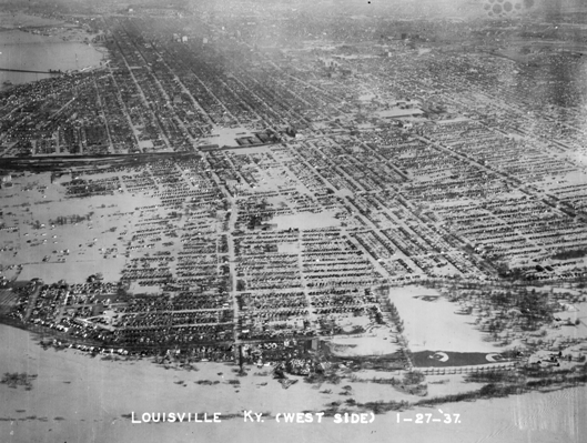 Louisville submerged
|
|
| The Great Ohio River Flood of January - February 1937 surpassed all prior floods during the previous 175 years of modern occupancy of the Ohio River Valley. The overall scope of the flood surpassed the major floods of 1884 and 1773, and geological evidence suggests the 1937 flood outdid any previous flood. Seventy percent of Louisville was submerged, forcing 175,000 residents to flee. 90 percent of Jeffersonville, Indiana, was flooded. One contemporary source estimated that damage was done to the tune of $250,000,000 (1937 dollars)...that's over $3.3 billion in current dollars!! At Louisville, the crest of the 1937 flood is still a full ten feet higher than the second highest crest (set in 1945). At McAlpine Lock, the 1937 flood crested at 85.4 feet. By way of comparison, flood stage is 55 feet. Louisville received fifteen inches of rain in only 12 days, from the 13th to the 24th of January. Over 19 inches of rain fell over the course of the month (Louisville's wettest month ever recorded). No measurable snow fell during the entire month. The NWS (Weather Bureau) office at the time was located in the Lincoln Building at the corner of Fourth and Market. Photo: Courier-Journal |
|
| 2. Whirling Tiger of the Air | |
| March 27, 1890 | |
 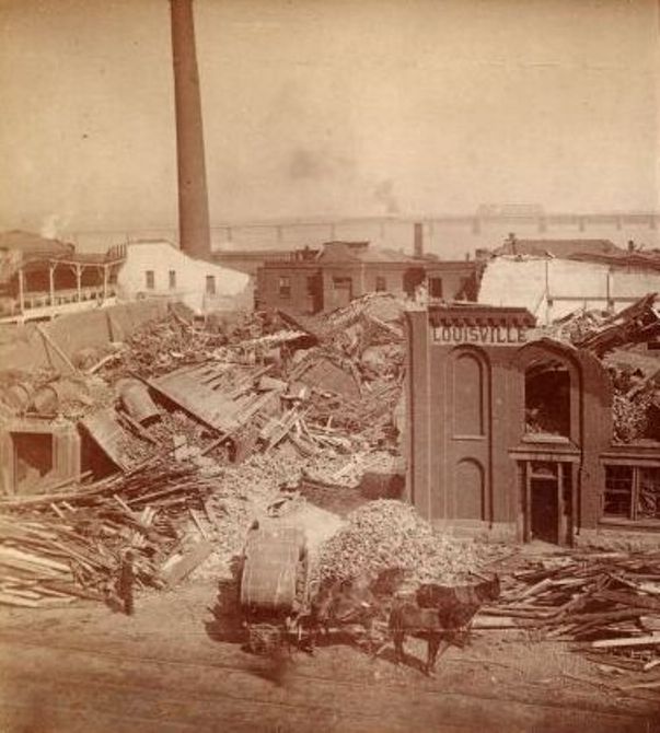 Destruction in Louisville Along Main Street Between Eleventh and Twelfth Streets |
|
| During the afternoon and evening of March 27, 1890, a massive tornado outbreak struck the Mississippi, Ohio, and Tennessee valleys with at least two dozen tornadoes of at least F2 strength. One of those tornadoes was a murderous F4 that tore directly into the west side of Louisville. The twister may have touched down as far west as Harrison County, Indiana, but the hardest-hit district was from the intersection of Algonquin Parkway and Thirty-Fourth Street northeastward through California and Russell into the west side of Louisville's Central Business District. The tornado roared into the Ohio River at the foot of Seventh Street, struck downtown Jeffersonville, and turned right and re-crossed the Ohio River coming back into Louisville where it severely damaged the water tower at the end of today's Zorn Avenue. The worst tragedy of the storm took place at Falls City Hall at 1124 West Market Street. A lodge meeting was taking place on the second floor of the building, while on the main floor several dozen children were taking dancing lessons with their mothers. As the great wind slammed into the building, windows shattered and the second floor fell onto the main level, followed by the rest of the building collapsing in on itself. An estimated 44 men, women, and children perished in the building's rubble, which remains as one of the highest single-building death tolls in the nation. In the city's newspaper the following day, the storm was called a "whirling tiger of the air." At least four other tornadoes struck central Kentucky that day, including a massive F4 that roared for 60 miles from Ohio County to Hardin County, holding the record for this area's widest tornado and longest tornado track. A total of 92 people in central Kentucky met violent deaths on March 27, 1890, with 76 of them in Louisville. |
|
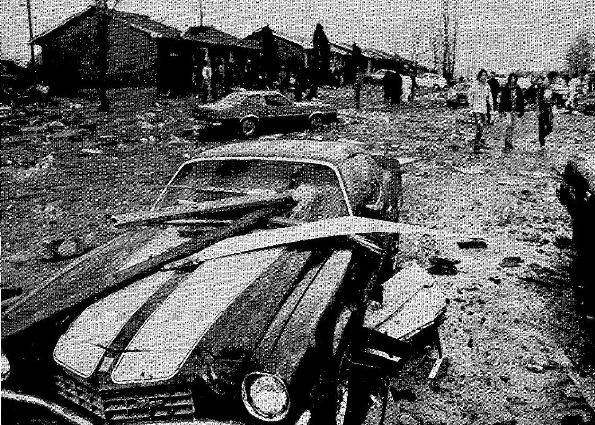
3. Super Outbreak!
|
|
April 3, 1974
|
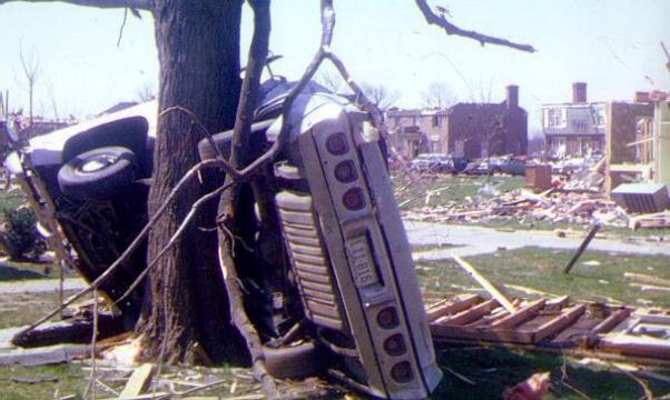 Northfield, Kentucky
|
| The most prolific tornado outbreak our region has ever seen took place on April 3, 1974 as 21 tornadoes dropped from the skies in just ten hours. The only two F5 tornadoes on record in southern Indiana and central Kentucky both took place on this same day. One of those F5 twisters slammed into downtown Brandenburg, Kentucky, resulting in 31 deaths. An F4 tornado touched down just southwest of Standiford Field in Louisville, and chewed northeast through the city and her suburbs before finally dissipating in Oldham County. Countless trees, some 200 years old, were ripped from the ground in Cherokee Park. The worst damage in the Louisville area took place in the affluent suburb of Northfield, where many large homes were destroyed in the blink of an eye. Though the death toll in Louisville was low, 60 people perished throughout the region. Photo: Russ Conger/NWS |
|
4. New Albany Cyclone
|
|
March 23, 1917
|
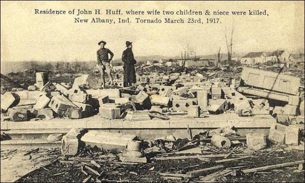 A home in New Albany swept away
|
| An F4 tornado touched down near Corydon and charged to the east, sweeping into New Albany. It continued on to the east, eventually crossing the Ohio River and entering Kentucky before dissipating just east of Harrod's Creek in Jefferson County. On its trip through New Albany's neighborhoods north of downtown around 3:30pm, widespread death and destruction resulted across a 90-block area. Many homes were destroyed and blown away and 54 people lost their lives. Several children were killed as the storm destroyed a school on the northwest side of town. Damage in New Albany, in current dollars, amounted to nearly $19 million. Photo: News and Tribune |
| 5. More Than Just the Tri-State |
| March 18, 1925 |
| Though the Great Tri-State Tornado gets all the attention, it was actually just one tornado out of a much larger outbreak of particularly devastating tornadoes from Kansas and Missouri east into Indiana and Kentucky. The outbreak was marked by unusually strong twisters, with two F4's and two F3's seen in southern Indiana and central Kentucky. One of the F4's completely obliterated farms across southern Harrison County, Indiana before moving into Jefferson County where it produced significant damage near Iroquois Park. It was a mile wide and killed four people in Harrison County. An F3 tornado then touched down near Anchorage and destroyed homes as it moved northeast into Pewee Valley. An F4 tornado that began in Tennessee came northeastward into southern Kentucky, where it killed four people at Holland in Allen County, and 8 people at Beaumont in Metcalfe County including 5 in one family. Scores of homes were damaged. Across southern Indiana and central Kentucky 48 people were killed and 235 injured. The outbreak included some of the widest and longest-lived tornadoes this area has ever recorded. |
|
6. Tompkinsville Tornado
|
| May 9, 1933 |
| An F4 tornado developed rapidly just southwest of Tompkinsville and moved straight into the city at 8:30pm. As it tore homes apart in the town, 18 people were killed. The storm grew to a mile wide as it plowed across northern Cumberland County and southern Adair County, and finally into Russell County. Near Russell Springs an additional 14 people lost their lives. For much more information, click here. |
| 7. Third Presbyterian Church Tornado |
|
August 27, 1854
|
| At noon a dreadful tornado entered Louisville, shredding many buildings and killing 25 people. Many folks were in church for noon services on that Sunday. As the tornado struck the Third Presbyterian Church at the corner of Eleventh and Walnut (now Muhammad Ali), the building was torn asunder and at least 18 parishioners were killed (55 people were in the structure and more may have died from injuries later). From the Louisville Democrat: The storm that passed over the city yesterday was one of the most destructive that ever occurred in the West. (At the Third Presbyterian Church) a mother and her three children were grouped in death. (Nearby were) a father, mother and babe -- the father dead, the mother mortally wounded, while their little child, placed beneath them, escaped unhurt, protected by the forms of its parents. From the Louisville Courier: It is not in the power of pen or language to describe the varied scenes and incidents of yesterday. Mothers in frantic agony seeking their children, wives their husbands, children their parents, as they wandered through the assembled crowd, filling the air with cries of mourning. Alas, each piercing shriek reveals the fact that some new dead form has been brought to light. Here comes a father borne along by friends, who take him from his bed of death; next the mother, and then the daughter and two sons -- all crushed -- mutilated -- dead! Truly, this is a house of mourning. The storm came in from the west around Twenty-Fifth Street, and lifted near the intersection of Fifth and Main. Strong straight-line winds accompanied the tempest and did damage along the riverfront, including sinking at least one schooner. |
| 8. Bowling Green Hailstorm |
| April 16, 1998 |
| During the mid-afternoon hours a huge supercell thunderstorm moved from northern Logan County through central parts of Warren, Barren and Metcalfe counties and then into western Adair County. An impressive swath of very large hail accompanied the storm across Logan and Warren counties. Many places along the route of the storm reported baseball size hail. Bowling Green was particularly devastated by the storm with incredible damage to all area car lots, all police cars, many homes, and Western Kentucky University. Every car dealership and rent-a-car lot had all of their cars totaled. In all, 8,300 homes, 900 mobile homes, 4,000 vehicles, 37 businesses, and 14 apartment buildings sustained major damage. Minor damage was reported to 1,300 homes, 6,000 vehicles, 42 businesses, and 4 churches. Most of this damage was attributed to the hail as opposed to the tornado that passed just to the south of Bowling Green. In fact the total damage attributed to hail was estimated at more than half a billion dollars. Several people also received minor injuries from being struck by the hail. |
| 9. July - August 1936 Heat and Drought |
|
Peaked July 7 - 15, 1936
|
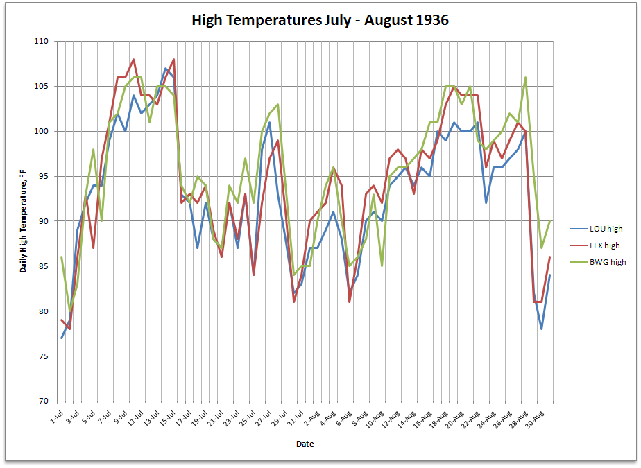 (click on the graph for a larger image) |
| The summer of 1936 is legendary for intense heat coupled with an extreme lack of rainfall. While the entire first half of the year was unusually dry, true drought conditions developed with a vengeance in June. Bowling Green suffered through the month with only twelve hundredths of an inch of precipitation, which still stands today as the third driest month on record, and the driest June on record. Similarly, Louisville received only 0.35" of rain (driest June on record) and Lexington got 1.18" of rain (2nd driest June on record). Then came the searing heat. The last few days of June saw afternoon temperatures reach around 100 degrees, followed by a brief break in the heat for the first three days of July. However, the hot weather had only just begun. Every day from July 8 through 15 all major reporting stations in Kentucky reported 100 degree temperatures. Louisville peaked at 107 on the 14th (their all-time high), Lexington hit 108 on the 10th and 15th (their all-time high), and Bowling Green struck 106 on the 10th and 11th. At night temperatures dropped only into the upper 70s and lower 80s. Hot summer weather continued for the rest of July, though not at record levels. Then in August another heat wave swept the region from the 16th to the 28th. Bowling Green recorded another ten 100 degree days during that stretch, peaking at 106 on the 28th. Louisville topped out at 101 on the 19th and 22nd, and Lexington made it to 105 on the 19th (their all-time high for August). The summer of '36 turned out to be the hottest summer ever recorded at Louisville, Lexington, and Bowling Green. It was also the 2nd driest at Lexington, third driest at Louisville, and eighth driest at Bowling Green. (Interestingly, the Great Drought ended just five months before the Great Flood -- see #1 above). Modern air conditioning had been invented in 1902, but didn't become commonplace in residential homes until the 1950s. |
| 10. Kentucky's Hottest Day |
|
July 28, 1930
|
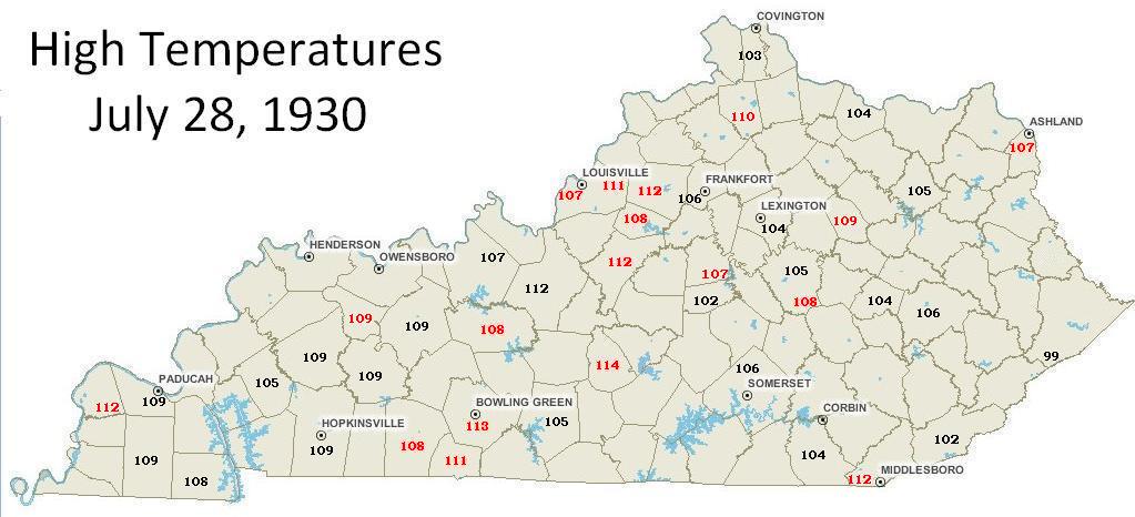 click on the image for a larger version |
| While the summer of 1936 was known for its prolonged heat and drought, arguably the hottest single day in Kentucky history occurred several years earlier. The map above (click on the image for a larger version) shows high temperatures from July 28, 1930. Nearly everyone saw readings above 100 degrees. The red values indicate all-time high temperature records set that day. July and August of 1930 were extremely hot and dry. Louisville recorded it's all-time driest July with only a quarter inch of rainfall. July 28 was one of a lengthy string of extremely hot days, with many weather stations reporting temperatures well over 100 degrees for several days before the 28th and a couple of weeks after. As a matter of fact, some of the stations that did not set all-time record highs on July 28 did set them in early August! |
|
11. 1901 Heat Wave
|
|
July
|
| At Bowling Green 30 of the month's 31 days had temperatures of at least 90 degrees, and 16 days saw at least 100 degrees. Every day from the 20th to the 29th had a high of at least 102! To add insult to injury, Bowling Green received a paltry 0.17" of rain, all of which fell within 48 hours! Louisville experienced twenty-seven 90 degree days and eight 100 degree days (7 of them consecutive) including 107 degrees on the 24th, which is the all-time record high for the city. Five of the record warm temperatures set during the month still stand today, over a century later, including the warm low temperature of 83 degrees on the 25th. Fortunately, Louisville benefited from heavy thunderstorms on the 3rd that brought 2.19" of rain, though the rest of the month was quite dry. Conditions weren't quite as bad at Lexington, which recorded only two 100 degree days and over three and a half inches of rain. The July 1901 heat wave was widespread and deadly across much of the eastern United States, with over 9500 heat-related casualties nationwide -- 724 of them in New York City alone. |
| 12. Record Snow and Cold | |
| January 17 - 19, 1994 | |
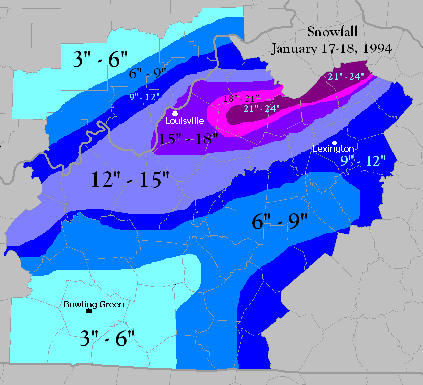 Snowfall January 17-18, 1994 (click on the image for a larger version) |
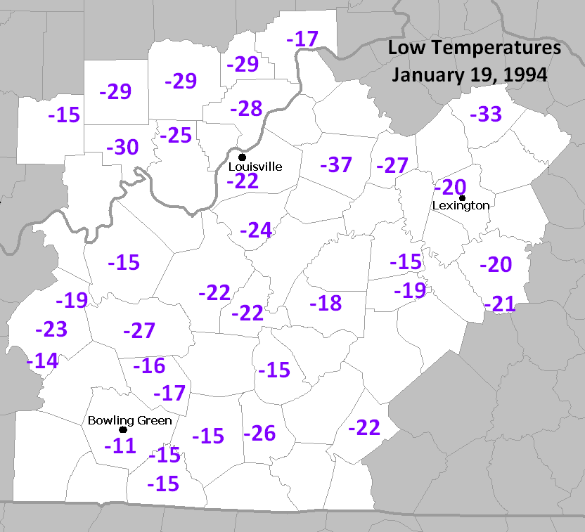 Low temperatures January 19, 1994 (click on the image for a larger version) |
| An intense winter storm brought copious amounts of snowfall to the region Monday the 17th, with all of Kentucky and southern Indiana receiving several inches of snow. A band of particularly heavy snow set up from Shelbyville through Cynthiana to Maysville where nearly two feet fell. At Louisville a single-day snowfall record of more than 15 inches was set. The heavy snow set the stage for what was to come next. Behind the storm an intensely cold air mass dumped south out of Canada, sending temperatures plunging well below zero by Wednesday the 19th. Not only did Louisville record an all-time low of -22 degrees, but Shelbyville set a new record low temperature for the entire state of Kentucky with a reading of -37! Lexington came within one degree of their all-time record low. |
|
| 13. Super Tuesday Outbreak |
| February 5-6, 2008 |
 |
| On the same day that 24 states were conducting primary voting for the 2008 presidential election, at least 84 tornadoes claimed 57 lives across the lower Ohio Valley and Southern United States. Much of the day was characterized by anomalously warm temperatures, with highs in many places across the South in the upper 70s to lower 80s, all ahead of a strong cold front. In Louisville, a high temperature of 68 was recorded at Standiford field on the 5th, with an early morning high of 67 on the 6th. The high temperature in Louisville on February 7, after the outbreak, was 36 degrees. Beginning around 10 PM local time, storms began moving through central Kentucky and southern Indiana, first as discrete cells, and later as a strong squall line. Eighteen twisters were confirmed, making Super Tuesday the second largest outbreak in number of tornadoes recorded, second only to the 21 confirmed tornadoes on April 3, 1974. Unlike the Super Outbreak, however, most of the tornadoes in the Louisville forecast area on February 5-6 were relatively weak, with short path lengths. Unfortunately, 4 people were killed by an EF3 tornado, all in Allen County, Kentucky. An additional EF3 tornado moved through Monroe County, and numerous EF2, EF1, and EF0 tornadoes occurred with the squall line as it raced across the Bluegrass Region of Kentucky. |
|
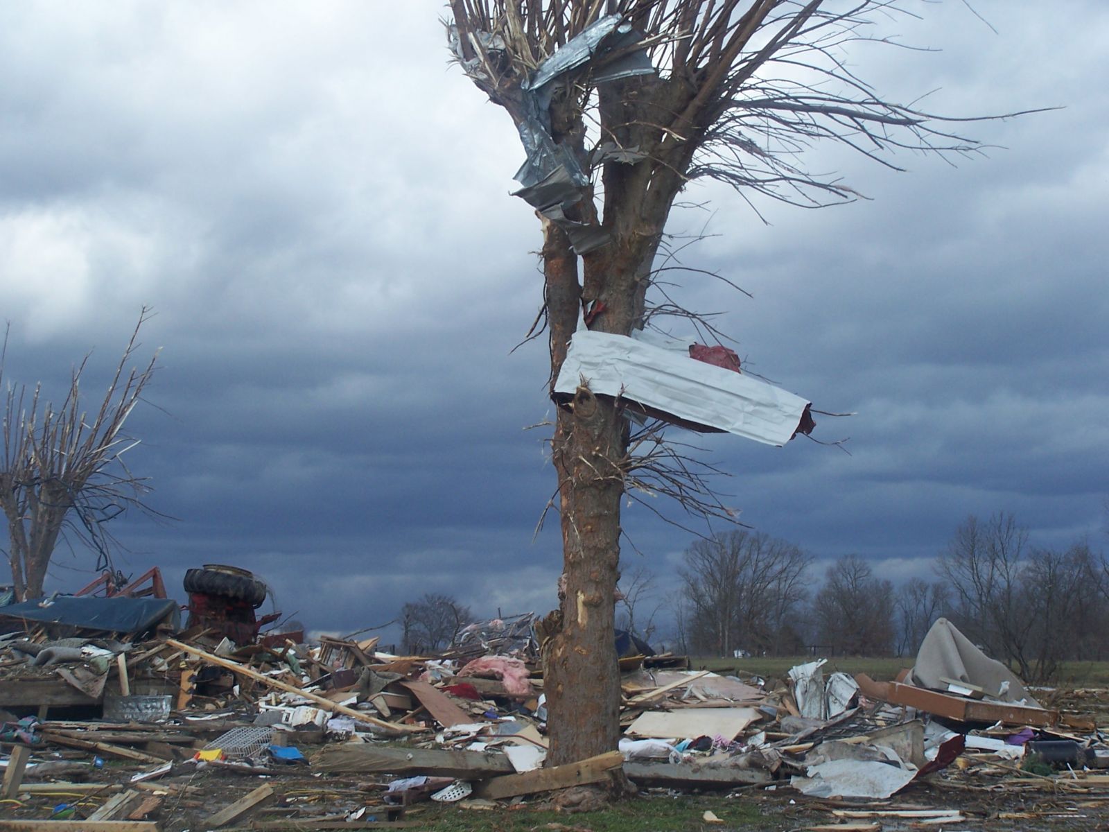
14. Bullitt County Tornado
|
|
|
May 28, 1996
|
|
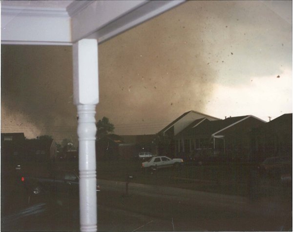 Too close for comfort! (click on the image for a larger version) |
 A bit safer distance. (click on the image for a larger version) Courtesy WAVE-TV |
| On the afternoon of May 28, 1996, a powerful thunderstorm developed over southwestern Dubois County, Indiana, and headed east. As it moved toward Crawford County, the storm split into two separate entities, with one moving to the northeast and the other to the southeast. Both storms produced large hail, but it was the southern storm that brought significant destruction to the area. After producing a tornado of F2 strength along a 10 mile path in Harrison County, Indiana, the supercell storm crossed the Ohio River into Kentucky. A new tornado quickly formed over Jefferson Memorial Forest in Jefferson County, cutting a wide gash through the woods. The tornado quickly gained strength and charged across Bullitt County, bringing great destruction to Brooks, Hillview, and Mount Washington. Witnesses reported multiple vortices swirling around the tornado, and suffered F3-F4 damage to their homes and businesses. Exhibiting a classic “hook echo” on National Weather Service Doppler radar, the twister then churned across Spencer County, producing F3 damage, before dissipating east of Taylorsville. The storm was responsible for over $100,000,000 in damages. Fortunately, thanks to effective warnings and quick public action, there were no fatalities. Ten people were injured, and over a thousand homes were damaged. |
|
| 15. 1951 Ice Storm and Cold Blast |
| January 29 - February 3, 1951 |
| An extremely strong high-pressure system started making its way into the region, pulling harsh, cold, polar air in with it. In the meantime, a strong low pressure system was moving through areas farther south along a cold front, stretching from the Gulf of Mexico and up into the Northeast. The cold front caused temperatures to drop, so that on the evening of January 30th, temperatures for Nashville, Tennessee, were only at 18 degrees Fahrenheit (-8 degrees Celsius). However, temperatures just above the surface at 5,000 feet were actually above freezing, registering at 48 degrees Fahrenheit (9 degrees Celsius). This was the perfect set up for the development and occurrence of freezing rain and sleet. In Bowling Green, almost 3 inches of snow and sleet had covered the city by morning of the 31st, causing roads to become almost impassible. By noon, the snow had turned to rain due to the above freezing warmer air aloft, however on the surface temperatures had only risen to 28 degrees Fahrenheit. This caused the rain to freeze upon impact, worsening the traffic situation. Bulldozers were called out to help the effort and scrape the ice, with little effect. Then a turn for the worse occurred yet again. By the next morning, on February 1, temperatures started dropping dramatically. Before the day was over a low of -1 degrees Fahrenheit had been recorded, and another 7 inches of snow had fallen. Travel by this point was virtually impossible, causing major delays for airlines, busses, and trains throughout the state. Damage was reported throughout the region as tree limbs cracked and fell onto power lines due to the dense ice packed onto them. The cold only continued. At 4:45 a.m. February 2, Bowling Green recorded a temperature of -20 degrees Fahrenheit, the coldest official temperature ever recorded up to that time. The precipitation continued as well, leaving behind 9 inches of snow and sleet on the ground in Southern Kentucky. Crews were working around the clock to restore both power and phone lines. Water pipes burst under the extreme cold, transportation remained halted, temperatures remained unbearable, and ten days later the area had yet to recover from the ice and the snow. The Great Ice Storm of 1951, as it came to be known, covered the south in a linear path of ice from Louisiana to Ohio. Heaviest accumulations fell in a line from Memphis to Nashville, Tennessee and northeastward into Lexington, KY. It was the costliest winter on record for the time, causing an estimated $100 million in damage. The impact on forest, livestock, crops and fruit trees was responsible for $64 million of that total. It is estimated that 25 people lost their lives across the areas affected by the storm, and another 500 were injured. |
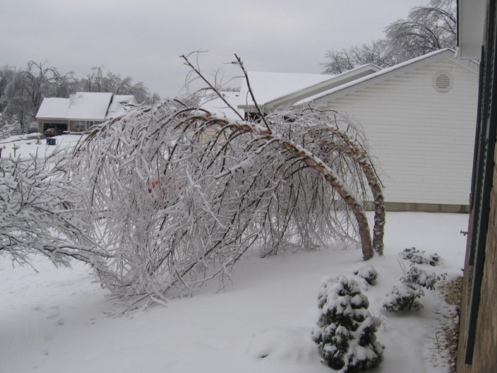
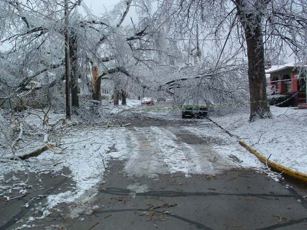
| 16. Ohio Valley Ice Storm |
| January 26-28, 2009 |
 |
|
A wintry mix moved into southern Indiana and central Kentucky on the night of Monday, January 26, 2009. Precipitation began as light freezing drizzle and freezing rain over the entire area, but changed to sleet and then snow overnight into the early morning hours of Tuesday across southern Indiana and northern Kentucky. Up to 6 inches of snow accumulated across the northernmost sections of the CWA. Freezing rain continued over southern Kentucky. On Tuesday the 27th, precipitation changed to freezing rain over southern Indiana and northern Kentucky, and to rain over southern Kentucky. Ice over an inch thick was reported in many locations from the freezing rain. Tuesday night freezing rain and sleet continued over southern Indiana, freezing rain transitioned to rain over northern Kentucky, and rain, occasionally heavy, continued over southern Kentucky. Minor...mainly river flooding developed in some spots by Wednesday from the steady rain. On the morning of Wednesday, January 28, precipitation changed over to snow from northwest to southeast across the area. About 3 to 4 inches of additional snow accumulation piled up in the north, with less to the south. The storm caused Kentucky's largest power outage on record, with 609,000 homes and businesses without power across the state. Property damage was widespread, with the damage due to falling trees, large tree limbs, and power lines weighed down by ice. In the Louisville metropolitan area, 205,000 lost power and it took up to 10 days to get everyone hooked back up. Area school systems were closed for an entire week. Several emergency shelters were set up across the affected region. In Louisville's local school system, 69 schools lost power. |
|
17. Kentucky's Record Rain |
|
March, 1997 |
|
In the Louisville metro area about $200,000,000 in damage was attributed to the flooding, with 50,000 homes affected. The crest of the river was reached on March 7 and hit 70.47 ft. Interstates 64 and 65 were closed. 92 counties in Kentucky and 14 counties in southern Indiana were declared disaster areas. Tens of thousands of people were evacuated from their homes, with total damage across the region around $400,000,000. Record flood stages were also attained at Paris on Stoner Creek, Cynthiana on the South Fork Licking River, Blue Lick Springs on the Licking River, and Boston on the Rolling Fork Salt River. Seven people in central Kentucky lost their lives due to the flooding. Photo: Judy Webber |
| 18. Bluegrass Ice Storm |
| February 15 - 16, 2003 |
 Lexington, Kentucky |
| By late afternoon on February 15, a cold dreary rain changed to freezing rain as northeast winds brought in colder air from southern Ohio. Thus began the infamous Bluegrass Ice Storm of 2003. Freezing rain fell nearly continuously through the next morning as temperatures fell into the upper 20s. Hardest hit were the cities of Frankfort and Lexington, where ice accumulations were around 1 inch on exposed branches and sidewalks. One person was killed in Lawrenceburg when struck by a falling ice-covered tree limb. Countless trees were destroyed and many area residents lost power for up to a week. According to the Kentucky Public Services Commission, power was knocked out to 280,000 customers. Over 3000 power poles were destroyed and nearly 800 transformers needed to be replaced. The total cost to area utilities was about $47 million, with another $26 million used by local municipalities to clean up the damage. Photo: Warren Hornsby |
|
19. 2007 Easter Freeze
|
|
April 5 - 10, 2007
|
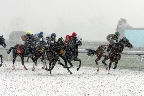 Record daily snowfall on April 6, 2007, for Opening Day at Keeneland Race Track in Lexington. |
| The last ten days of March 2007 had been unusually warm, with high temperatures in the 70s and 80s each day. A cold front passed through the region on April 3, which brought extensive severe weather and also ushered in a massive dome of frigid Canadian air. From the 5th to the 10th of April temperatures dropped into the 20s and 30s each morning throughout the entire region. Bowling Green spent a total of 47 hours (non-consecutive) below freezing, bottoming out at 22 degrees on the 8th. Louisville fell to 25 on the 7th and Lexington dropped to 22 degrees on both the 7th and 8th. The March warmth caused significant early spring crop and plant growth, which was then devastated by the six straight days of well below freezing temperatures in April. Losses were suffered in nearly all crops, including peaches, apples, pears, cherries, raspberries, blackberries, strawberries, blueberries, grapes, corn, soybeans, and wheat. Almost all of the peaches were destroyed. Half of the wheat crop was destroyed with $63,000,000 in damage. The corn crop recorded $5,000,000 in losses. Of the twenty million dollar fruit industry, $16,000,000 in damage was incurred. Depending on the variety, up to 90% of grape crops were lost. Total losses in this region were well over $130,000,000. Drought set in over the summer and early fall months of 2007, which caused additional stress on local agriculture, but it was the April freeze that did the lion's share of the damage. Photo: Steve Blake |
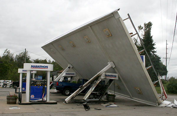
| 20. Ike's Windstorm |
| September 14, 2008 |
 |
|
The remnants of Hurricane Ike, which had devastated the Galveston and Houston areas the day before, charged to the northeast through the Ohio and Mississippi valleys. Wind gusts to hurricane force were recorded as far north as southern Indiana. Countless trees were blown down across southern Indiana and western sections of central Kentucky. In the Louisville area, 301,000 people lost power, which was a new record for the city. 1400 power lines were torn down, hundreds of power poles snapped, and 130 roads blocked by debris. Some areas waited nearly two weeks for electricity to be restored, and some counties declared states of emergency. Four people were killed by falling trees and limbs. A special page has been developed for this event, with many photographs of the widespread damage. |
| 21. Christmas '04 Snowstorm |
| December 22 - 23, 2004 |
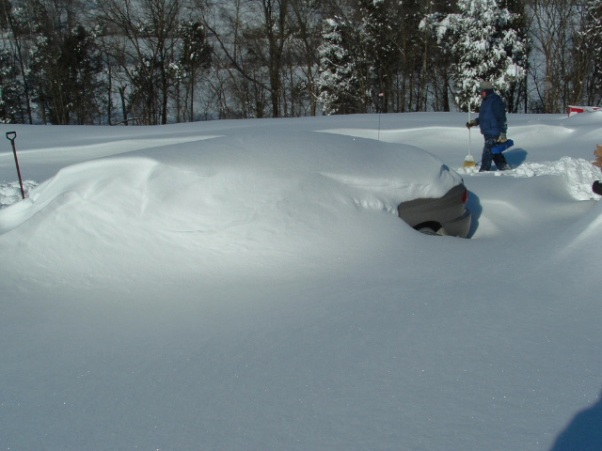 A car buried in snow in Milltown, Indiana. |
| During the 2004 snowstorm snow fell in southern Indiana at rates of as much as four inches per hour with storm totals as high as 32 inches and drifts to five feet. In Louisville, six inches of sleet combined with several inches of snow. Power was out for two days to 33,000 Louisvillians. Thundersnow and thundersleet were observed during the height of the storm. Farther south in central Kentucky, freezing rain deposited an inch of solid ice on all exposed outdoor objects, causing some roof collapses. Interstate 64 was closed for three full days. Interstate 65 was still down to just one passable lane in places on Christmas Day. The timing of the storm was unfortunate, occurring on some of the busiest travel days of the year, and stymieing last-minute Christmas shopping. Local businesses lost up to 80% of their expected sales during the storm. Photo: Angela Crecelius |
| 22. 1998 Snowstorm |
| February 3 - 6, 1998 |
|
A very unusual winter storm paralyzed the region in early February of 1998. The storm dumped up to two feet of snow across parts of northern and eastern Kentucky, and used moisture from the Atlantic Ocean rather than from the Gulf of Mexico to do it. Around central Kentucky, snow depths at the end of the onslaught were over a foot, with a snowpack two feet deep reported at Liberty in Casey County. At Louisville, February 4, 1998 still stands as the 5th snowiest single day on record, the snow depth of 18 inches on February 6, 1998, is the city's 2nd deepest snow depth on record, and February 1998 stands as Louisville's 4th snowiest month in history. In Lexington, unofficial reports of a snow fall of 11 inches on the 4th and a depth of 18 inches were received. |
| 23. April '71 Outbreak |
| April 27, 1971 |
| On this day, 6 twisters moved across southern Indiana and central Kentucky, killing 9. Six of those lives were taken as an F4 ripped through the vicinity of Mt. Pleasant Church, a few miles northeast of Columbia in Adair County. 2 more lives were taken in Russell County, as another F4 tore a path of destruction through Gosser Ridge. An F3 tornado killed one person as it moved through Butler and Warren Counties. Along the nearly 30 mile path, a six-room brick house was destroyed, along with several large trailers. |
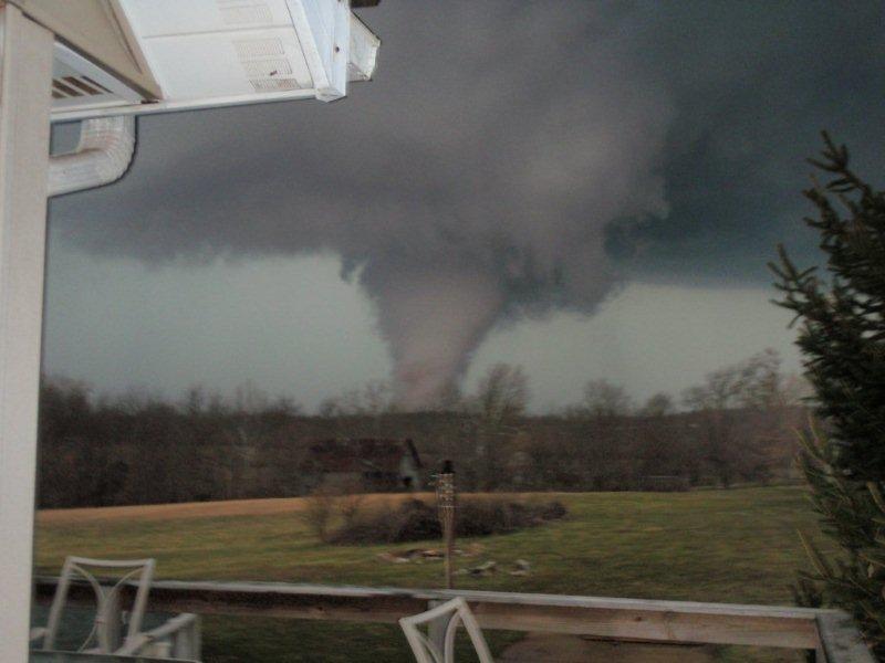
| 24. Henryville EF-4 |
| March 2, 2012 |
|
|
|
This early season tornado averaged a forward speed of 60 mph along its 49-mile long path from Fredericksburg, Indiana to south of Milford, Kentucky. Early in its path it quickly intensified to EF3 strength and ripped asphalt from the ground as it crossed IN 135. The first EF4 damage was soon thereafter in the Daisy Hill community along the Washington/Clark County line. The funnel laid bare a path through Clark State Forest and then tore directly into Henryville, still at EF4 strength, destroying the school complex. The Marysville and Chelsea areas of Clark and Jefferson Counties were next in line and suffered extreme damage. The twister crossed the Ohio River at Lee Bottom and finally dissipated in central Trimble County, Kentucky. Eleven lives were lost. Photo: Mark Schweiger |
|
25. Ak-Sar-Ben Park Tornado
|
| March 10, 1986 |
 The tornado turned these boards into deadly missiles in Ak-Sar-Ben Park. |
| In what was arguably Lexington's worst tornado, a near-F3 twister touched down at 5:50pm in the vicinity of the intersection of Man O' War Boulevard and Tates Creek Road. The storm moved to the east-northeast, maintaining an F2 strength for most of its three and a half mile long path. The tornado ended just east of Hunters Point Drive near Lexington Reservoir. In the subdivisions of southeast Lexington 845 homes were damaged and 55 completely destroyed. Ak-Sar-Ben Park suffered the worst damage, with many homes unroofed. There were no fatalities, but 20 people were hospitalized with injuries. Damages totaled about $9.5 million (2007 dollars). Photo: Ron Garrison/Lexington Herald-Leader |


 Weather Story
 Weather Map
 Local Radar
 Follow us on YouTube