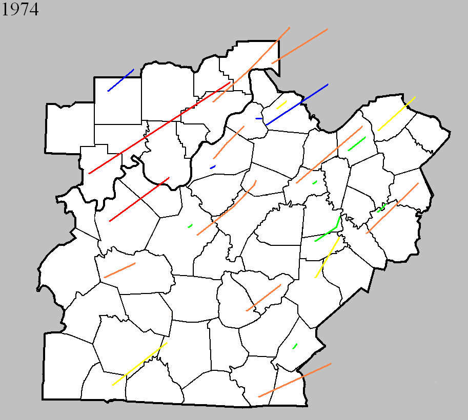
March 29, 1974
Counties: Hardin
F-scale: F2
Deaths:
Injuries: 8
Path width:
Path length:
Time: 6:45pm
Noted discrepancies: SPC/NCDC list this as an F2, Grazulis does not list it.
March 29, 1974
Counties: Anderson
F-scale: F2
Deaths: 0
Injuries: 2
Path width: 100 yards
Path length: 2 miles
Time: 8:00pm
Grazulis narrative: A trailer and a barn were destroyed at Lawrenceburg. A home was unroofed, and other buildings were damaged.
Noted discrepancies: SPC and NCDC give a path length of 1 mile, Grazulis and Storm Data give 2 miles.
March 29, 1974
Counties: Russell
F-scale: F2
Deaths:
Injuries: 1
Path width:
Path length:
Time: 9:00pm
Grazulis narrative: A tornado destroyed two trailers and a barn, just north of Jamestown.
Noted discrepancies: SPC and NCDC give a time of 9:00pm, Grazulis and Storm Data five 10:00pm.
April 1, 1974
Counties: Henry
F-scale: F3
Deaths: 1
Injuries: 20
Path width: 300 yards
Path length: 3 miles
Time: 6:20pm
Grazulis narrative: About 100 of the 500 residents of Campbellsburg were left homeless. Nineteen homes and 23 businesses were destroyed or damaged.
Noted discrepancies: SPC and NCDC list this as an F3, Grazulis calls it an F2.
April 3, 1974
Counties: Orange (to Lawrence)
F-scale: F1
Deaths:
Injuries:
Path width:
Path length:
Time: 1:15pm
Noted discrepancies: NCDC only lists Orange County, but the NCDC liftoff lat/lon is in Lawrence County. Storm Data seems only to list Lawrence County, with the tornado hitting form the junction of US 50 and IN 235 to just north of Freetown. More research is needed.
April 3, 1974
Counties: Perry, Crawford, Harrison IN, Washington IN, Clark IN, Scott IN
F-scale: F5
Deaths: 6
Injuries: 76
Path width:
Path length:
Time: 1:20pm
Grazulis narrative: Moved east-northeast and northeast from three miles south of Huffman, passing southeast of Branchville, north of Sulphur Springs and Pilot Knob, south of Sulphur and Curby, across the southeast part of DePauw, hitting two miles east of Palmyra, passing through Martinsburg, crossing the southeast half of Daisy Hill, passing between Bunker Hill and New Liberty, and ending two miles north of IN 160. This tornado immediately killed a woman as it destroyed her mobile home. As the tornado passed along southeast of Branchville it killed again. Two people, riding in a school bus, saw the tornado and took shelter in a nearby ditch. The bus was thrown fifty feet into the ditch, crushing the couple and killing the woman. Moving across Crawford County, the tornado widened to over a mile, missing many small communities and levelling several farms. In Harrison County the tornado killed a woman in her mobile home in southeast Depauw. Another woman was killed in her home two miles east of Palmyra. In the southeastern corner of Washington County the tornado struck the town of Martinsburg, destroying 38 of the town's 48 homes. Homes in the Daisy Hill area were completely swept away.
Noted discrepancies: SPC and Grazulis list 6 deaths for this tornado, NCDC lists 5. SPC lists 86 injuries, NCDC 53, Grazulis 76, Storm Data 95. SPC lists a path length of 68 miles, NCDC 50 miles, Grazulis 62 miles, Storm Data 67 miles. SPC gives a path width of 10 yards (obviously incorrect), NCDC 30 yards (obviously incorrect), Grazulis 1760 yards, Storm Data 700 yards. This tornado is split into two tornadoes at SPC. Grazulis lists an incorrect ending point for the tornado. Storm Data begins this tornado between Huffman and Tarry in Perry County and lifts it a few miles northeast of Lexington in Scott County. SPC lat/lon ends the tornado southwest of Lexington, rather than northeast. It's been mapped here according to the information in Storm Data, but additional research would be helpful.
Note: NCDC has an entry for a F5 in Clark County IN at 2:10pm that does not appear in the SPC database nor in Grazulis
April 3, 1974
Counties: Clark IN, Scott IN, Jefferson IN (to Ripley)
F-scale: F4
Deaths: 11
Injuries: 190
Path width: 1200 yards
Path length:
Time: 2:19pm
Grazulis narrative: Moved northeast from just northeast of Henryville, passing near Nabb, hitting Hanover and North Madison and the northwest edge of China, passing northwest of Canaan and ending three miles west of Cross Plains. One person was killed in Scott County. The tornado then moved into Jefferson County, heading towards Hanover. Hanover College was torn apart, sustaining ten million dollars in damage, with a few students injured. No homes were leveled there, but the tornado intensified as it passed north of Madison, and killed seven people in that area. About 300 homes were destroyed along the northern edge of Madison. Many of the homes that were leveled were the most expensive in the county. Continuing to the northeast and north-northeast the tornado killed people as it passed along the edge of China.
Noted discrepancies: NCDC doesn't list Ripley County. SPC gives a path length of 36 miles, NCDC gives 35 miles, Grazulis 38 miles. SPC and NCDC give a path width of 1200 yards, Grazulis give 800 yards.
April 3, 1974
Counties: Breckinridge, Meade, Harrison IN
F-scale: F5
Deaths: 31
Injuries: 270
Path width:
Path length: 32 miles
Time: 2:20pm
Grazulis narrative: Touching down five miles southwest of Hardinsburg, Breckinridge County, the tornado passed along the northern edge of that town, with F3 damage to homes. Thirteen people were injured and 35 homes were destroyed as the funnel moved to the northeast across Breckinridge County and into Meade County. The tornado gradually enlarged and intensified as it approached Brandenburg. The funnel devastated that town and crossed the Ohio River into Harrison County, Indiana. At Brandenburg 128 homes were completely destroyed, many of them levelled and swept away. Thirty businesses were destroyed and damage totalled over ten million dollars. There were 28 deaths in the Brandenburg area. The F4 damage occurred from north of Irvington, into Indiana.
Noted discrepancies: SPC and NCDC give a time of 2:20pm, Grazulis gives 3:25pm, Storm Data 3:30pm. SPC and NCDC give a path length of 32 miles, Grazulis gives 34. SPC and NCDC give a path width of 430 yards, Grazulis give 800 yards.
April 3, 1974
Counties: Jefferson IN (to Switzerland, Ohio IN, Dearborn)
F-scale: F4
Deaths: 0
Injuries: 104
Path width:
Path length: 28 miles
Time: 2:40pm
Grazulis narrative: While the Madison tornado veered to its left, this tornado touched down just south of Manville. It moved northeast, leveling homes and forests west of Fairview, leveling a church north of Bear Branch, passing south of Milton, and lifting near Wilmington.
Noted discrepancies: SPC gives a path length of 27 miles, NCDC and Grazulis 28 miles. SPC and NCDC give a path width of 1133 yards, Grazulis give 800 yards.
April 3, 1974
Counties: Grayson
F-scale: F4
Deaths: 0
Injuries: 2
Path width: 150 yards
Path length:
Time: 3:00pm
Grazulis narrative: Moved east-northeast from Tanyard to south of Caneyville, passing north of Leitchfield and ending near Big Clifty. The F4 rating is based on a single leveled home south of Caneyville
Noted discrepancies: Grazulis takes this tornado into Hardin County, though he says the damage ended at Big Clifty, which is in Grayson County about two miles from the Hardin County line. SPC/NCDC end it on the northwest side of Leitchfield. SPC and NCDC give a time of 3:00pm, Grazulis and Storm Data give 4:00pm. SPC and NCDC give a path length of 14 miles, Grazulis give 28 miles. Storm Data begins this tornado in Grayson County east of Tan Yard, takes it through Caneyville, north of Leitchfield, to Big Clifty. Storm Data seems to then continue the tornado into Hardin County to Colesburg (or could that be part of the tornado listed at 3:45pm from Hardin to Spencer counties?). For now will map using SPC coordinates, ending the tornado just northwest of Leitchfield. Further research necessary.
April 3, 1974
Counties: Jefferson KY, Oldham
F-scale: F4
Deaths:
Injuries:
Path width: 200 yards
Path length:
Time: 3:37pm
Grazulis narrative: Moved northeast from the Kentucky State Fairgrounds in Louisville. Dozens of buildings and hundreds of trees were destroyed in Louisville. About a dozen expensive homes were destroyed in affluent suburbs of northeast Louisville. About 425 homes were destroyed in Jefferson County, and 25 were damaged in Oldham County. Losses on one Oldham County farm amounted to $200,000.
Noted discrepancies: SPC and NCDC list three fatalities, Grazulis 2, Storm Data 6. SPC and NCDC list 225 injuries, Grazulis lists 228, Storm Data 243. SPC lists a path length of 19 miles, NCDC 18 miles, Grazulis 21 miles. SPC lists a path width of 10 yards (obviously incorrect), NCDC 30 yards (obviously incorrect), and Grazulis 200 yards.
April 3, 1974
Counties: Hardin, Nelson, Spencer
F-scale: F4
Deaths: 3
Injuries: 81
Path width: 400 yards
Path length: 40 miles
Time: 3:45pm
Eyewitness narrative: I was 15 years old at the time and I lived on KY 44 just east of Elk Creek in Spencer County. The storm came up from near Cox's Creek where the Whitney Horse Farm was damaged, crossing Lilly Pike where several homes, barns, and trailers were demolished, across Murray Road, and then across KY 44 and on to the Elk Creek community. On Murray Road a father and son were in their milking barn when they saw the storm approach. They got under some heavy equipment for shelter and the barn came down around them. They were rescued several hours later as workers and neighbors cleared Murray Road of trees and debris. The father was taken to the hospital in critical condition but the son was OK. As the twister crossed Murray Road and Elk Creek it was about 300 yards wide. The tornado broke into vortices at my home on KY 44 and circled around the house. Our neighbors between us and the creek lost their roof, which landed 300 yards to the east of their home mostly intact. Witnesses said that the main tornado broke into two vortices, the larger one of which hit the house to our west while the other went to the east and damaged a farm on Carl Monroe Road just south of KY 44. My home was in between the two vortices and was spared. The two vortices came together on the north side of KY 44 across from my house and destroyed a large tobacco barn. Debris from the barn could be seen circling the tornado and was thrown to the southeast. I saw the tornado start to rope out at this point. It touched down again in Elk Creek but didn't do much more damage.
Grazulis narrative: Moved northeast from northwest of Elizabethtown, destroying businesses as it passed two miles north of that town along the miracle mile strip on US 31W. Two people were killed in this area. One person was killed as 15 homes were destroyed near Cox's Creek, Nelson County. The funnel lifted two miles north of Fairfield. Nelson County lost 52 homes and about 100 barns.
Noted discrepancies: Grazulis takes this tornado into Bullitt County as well. The path Grazulis describes seems to keep the tornado just barely inside Nelson County, though it does indeed come very close to the Bullitt County line. Grazulis lifts the tornado two miles north of Fairfield, but SPC/NCDC take it to north of Wakefield. Storm Data may begin this tornado at Colesburg in Hardin County...then it reports continuous damage from 3 miles north of Boston to Samuels to 2 miles north of Fairfield. Storm Data lists Hardin, Nelson, and Spencer counties. SPC/NCDC give a path length of 38 miles, Grazulis gives 42 miles. SPC gives a path width of 10 yards, NCDC 30 yards, Grazulis 400 yards. Grazulis' path width is probably the most correct.
April 3, 1974
Counties: Simpson, Warren, Barren
F-scale: F3
Deaths: 3
Injuries: 57
Path width:
Path length:
Time: 3:45pm
Grazulis narrative: Moved northeast from west of Gold City to east of Smiths Grove. One person was killed in Simpson County at Temperance as seven homes and 40 barns were destroyed. Two people died in Warren County: one at Three Forks and one at Rocky Springs.
Noted discrepancies: SPC, NCDC, and Grazulis give a time of 3:45pm...Storm Data says 4:45pm. SPC and NCDC give a path length of 31 miles...Grazulis says 25 miles. SPC gives a path width of 10 yards...NCDC 30 yards...Grazulis nothing.
April 3, 1974
Counties: Henry (to Owen)
F-scale: F1
Deaths: 0
Injuries: 18
Path width: 30 yards
Path length: 32 miles
Time: 4:15pm
Noted discrepancies: SPC gives a path length of 32 miles, NCDC 31 miles. SPC gives a path width of 10 yards, NCDC 30 yards.
April 3, 1974
Counties: Green, Taylor
F-scale: F4
Deaths: 0
Injuries: 56
Path width: 800 yards
Path length:
Time: 4:40pm
Grazulis narrative: Moved northeast from south of Greensburg to Mannsville, destroying a large part of that town. About 50 homes and 60 barns were destroyed, and 40 of those were at Mannsville, with seven of them leveled to the ground.
Noted discrepancies: SPC and NCDC give a time of 4:40pm, Grazulis and Storm Data give 5:40pm. SPC gives a path length of 20 miles...NCDC gives 21 miles...Grazulis give 29 miles. SPC gives a path width of 10 yards...NCDC 30 yards...Grazulis 800 yards. Grazulis' width is probably most correct.
Notes: Storm Data says this tornado hit Mannsville, Burdick, Meadow Creek, and White Ridge.
April 3, 1974
Counties: Anderson, Franklin, Scott KY
F-scale: F4
Deaths: 4
Injuries: 122
Path width: 800 yards
Path length:
Time: 4:50pm
Grazulis narrative: Moved northeast near Alton, passing along the south and southeast edge of Frankfort, where homes were leveled and four people were killed. About 120 homes were damaged or destroyed near Frankfort, as were businesses and factories. Twelve homes were destroyed near Alton. The funnel passed near Stamping Ground and lifted near Sadieville.
Noted discrepancies: NCDC does not give a liftoff lat/lon. SPC gives a path length of 79 miles...NCDC gives 81 miles (including 54 miles in Scott County, which is impossible), and Grazulis gives 36 miles. NCDC/SPC start this tornado on the western Anderson County line west of Gee...Grazulis starts it in Anderson County but farther east at Alton. SPC gives a path width of 10 yards, NCDC 30 yards, Grazulis 800 yards. Grazulis probably has the most correct path width. For this mapping project we used the official start/stop lat/lons, but further research is needed to verify. (The ending lat/lon given by NCDC for the Franklin County portion of the track is wrong.)
April 3, 1974
Counties: Casey, Lincoln, Boyle
F-scale: F3
Deaths: 1
Injuries: 98
Path width:
Path length: 18 miles
Time: 5:35pm
Grazulis narrative: Moved north-northeast from five miles southwest of Hustonville, passing through Junction City and ending at the south end of Lake Herrington northeast of Danville. Over 100 homes were severely damaged or destroyed at Junction City. Losses totalled five million dollars in Lincoln County.
Noted discrepancies: SPC and NCDC give a path length of 21 miles...Grazulis give 18 miles. SPC gives a path width of 10 yards, NCDC gives 30 yards, Grazulis doesn't know. Grazulis lists this tornado at 6:35pm.
April 3, 1974
Counties: Cumberland, Clinton (to Wayne)
F-scale: F4
Deaths:
Injuries: 96
Path width: 800 yards
Path length:
Time: 5:40pm
Grazulis narrative: Moved northeast from two miles south of Kettle, to Ida, eight miles northwest of Albany, to 76-Falls, to Piney Woods, and finally to Mill Springs. Eight people were killed in five different small Clinton County communities as 50 homes were damaged or destroyed.
Noted discrepancies: Grazulis and Storm Data list this tornado at 6:40pm...SPC and NCDC say 5:40pm. This time disagreement may have something to do with the tornado being near a time zone boundary. SPC and NCDC list 8 fatalities, Grazulis and Storm Data list 10. Storm Data and NCDC list 113 injuries, Grazulis 96. SPC gives a path length of 38 miles...NCDC says 39 miles...Grazulis 30 miles...Storm Data 35 miles. SPC gives a path width of 10 yards, NCDC gives 30 yards, Storm Data 587 yards, Grazulis 800 yards. Grazulis probably has the more correct path width. There were two F4's in Wayne County on this day, so that may be adding to some of the confusion, especially with the injury numbers.
Notes: Storm Data lists this as "twin tornadoes" from two miles south of Kettle to Ida to 76-falls to Piney Woods to Mill Springs. Will go ahead and list 96 injuries for this tornado since that number is known for Cumberland and Clinton counties, and Wayne County is not in this project's area of concern.
April 3, 1974
Counties: Harrison KY (to Robertson)
F-scale: F3
Deaths: 0
Injuries: 27
Path width:
Path length:
Time: 5:55pm
Grazulis narrative: Moved northeast from Lee's Lick to west of Cynthiana, east of Poindexter, ending near Claysville. Forty homes and 75 barns were destroyed. Near-F4.
Noted discrepancies: SPC and NCDC give a path length of 19 miles...Grazulis gives 25 miles. SPC gives a path width of 10 yards...NCDC says 30 yards...Grazulis doesn't say. Storm Data seems to only list Harrison County. Grazulis puts this tornado at 6:55pm.
April 3, 1974
Counties: Boyle, Mercer
F-scale: F2
Deaths: 0
Injuries: 10
Path width:
Path length: 16 miles
Time: 6:12pm
Grazulis narrative: Moved north-northeast from five miles west of Danville to the east side of Pleasant Hill, passing two miles east of Harrodsburg and ending about eight miles northeast of that town. Ten people were injured in rural Boyle County. In Mercer County four homes and 26 homes were destroyed. Thirty-four homes were damaged.
Noted discrepancies: NCDC gives no liftoff lat/lon. SPC gives a path length of 16 miles, NCDC 17 miles, Grazulis 18 miles. SPC gives a path width of 10 yards, NCDC 30 yards, Grazulis nothing.
Notes: Storm Data begins this tornado near Nevada, moving it to the east side of Burgin, then curving northward to 3/4 of a mile west of Dix Dam, to the east side of Pleasant Hill.
April 3, 1974
Counties: Garrard, Madison, Clark KY
F-scale: F4
Deaths: 7
Injuries:
Path width: 300 yards
Path length:
Time: 6:20pm
Grazulis narrative: Moved northeast from near Hackley and Cottonburg, passing just north of Richmond, and lifting east of Mount Sterling. Thirty homes were destroyed, with F4 damage and deaths in southwest Madison County, mostly near Richmond. About 100 people were left homeless in Clark County.
Noted discrepancies: SPC, Storm Data, and NCDC give 28 injuries, Grazulis give 27. SPC and NCDC give a path length of 32 miles, Grazulis give 35 miles,Storm Data 22 miles. SPC gives a path width of 10 yards, NCDC 30 yards, Storm Data 133 yards, Grazulis 300 yards. Grazulis takes this tornado into Montgomery County, ending it east of Mount Sterling. SPC and NCDC end the tornado in Clark County east of Mount Zion. Grazulis places this tornado at 7:20pm.
Notes: Grazulis' path width is probably the most correct. Storm Data begins this tornado at Cottonburg, moving it to two miles north of Whitehall and beyond. According to the Garrard County weekly Central Herald, there were seven injuries in Garrard County, which are not accounted for at the NCDC webpage (it lists zero injuries for the Garrard County portion of this tornado). Grazulis doesn't many any specific locations of the injuries he reported.
April 3, 1974
Counties: Madison, Fayette
F-scale: F2
Deaths:
Injuries: 0
Path width:
Path length:
Time: 6:30pm
Grazulis narrative: Moved northeast near Valley View, destroying buildings in the southeast part of (Fayette County).
Noted discrepancies: Grazulis does not include Madison County. NCDC does not include Fayette County. NCDC gives no endpoint lat/lon. SPC starts the tornado in Madison County just south of Valley View, which is in Madison County near the point where Madison, Jessamine, and Fayette counties meet (but definitely in Madison County). The way the Kentucky River winds through the area, the SPC track takes the tornado from near Valley View in Madison County, into southernmost Lexington in Fayette County, and then back into Madison County. Storm Data mentions only that this tornado "touched down briefly" near where I-75 crosses the Fayette/Madison County line. SPC and NCDC give a path length of 5 miles, Grazulis gives 9 miles. SPC gives a path width of 10 yards, NCDC 30 yards, Grazulis nothing.
April 3, 1974
Counties: Scott KY
F-scale: F2
Deaths: 0
Injuries: 20
Path width:
Path length:
Time: 7:15pm
Grazulis narrative: Moved east-northeast from five miles southeast of Stamping Ground to Muddy Ford. There were 134 "uninhabitable" homes.
Noted discrepancies: SPC and NCDC list a path length of 10 miles, Grazulis says 14 miles. SPC gives a path width of 10 yards, NCDC 30 yards, Grazulis nothing. Grazulis lists this tornado at 8:15pm.
April 3, 1974
Counties: Butler
F-scale: F1
Deaths:
Injuries:
Path width:
Path length:
Time: 7:25pm
Noted discrepancies: SPC/NCDC lat/lon place this tornado in Mason County. Unable to plot, pending further research.
April 3, 1974
Counties: Russell (to Pulaski, Rockcastle)
F-scale: F3
Deaths:
Injuries:
Path width:
Path length:
Time: 10:30pm
Noted discrepancies: NWS ranks this as an F3, but Grazulis does not list it. NCDC lists only Pulaski and Rockcastle counties. SPC lists only Pulaski County lat/lons. SPC lists a path width of 10 yards, NCDC 30 yards. The SPC/NCDC touchdown lat/lon is just barely inside Pulaski County. Storm Data moves this tornado from near Mount Victory, which is nowhere near the lat/lons given for Pulaski County, then along the Laurel/Rockcastle county line (but listing only Rockcastle County). This tornado is unplottable, pending further research.
Special note: Did Fujita's tornado #82 clip the southeast tip of Clinton County on April 3, 1974? So far, it doesn't look like it...
May 29, 1974
Counties: Jefferson KY
F-scale: F1
Deaths:
Injuries:
Path width:
Path length:
Time: 10:28pm
Noted discrepancies: None
June 22, 1974
Counties: Oldham
F-scale: F1
Deaths:
Injuries:
Path width:
Path length:
Time: 6:20pm
Noted discrepancies: None


 Weather Story
 Weather Map
 Local Radar
 Follow us on YouTube