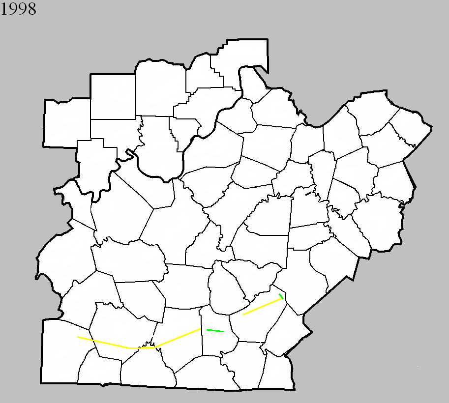
April 16, 1998
Counties: Logan, Warren, Allen, Barren
F-scale: F3
Deaths: 2
Injuries: 9
Path width:
Path length: 58 miles
Time: 2:35pm
Notes: After researching this tornado (see discrepancies below), including reviewing radar data, it appears this tornado touched down at Chandlers Chapel in northeast Logan County, moving through Warren County crossing I-65 about seven and a half miles south of Bowling Green, continuing eastward into northernmost Allen County passing just north of Meador, then turning to the northeast near Finny, Haywood, three miles south of Glasgow, and ending at the Metcalfe County line near where the parkway crosses the border. The worst damage was in Barren County. Homes on Needmore School Road southwest of Haywood were extensively damaged, and a mobile home was flipped over near the intersection of Riddle Road and KY 249. In Glasgow one person was killed in his mobile home and another was killed by flying debris. In the Glasgow area one house was destroyed (F3 damage) and 45 badly damaged. Winds estimated at 175mph near Glasgow damaged or destroyed 35 mobile homes and 25 barns.
Noted discrepancies: SPC mistakenly replaces Warren County with Lawrence County. SPC gives a beginning latitude of 36.92...NCDC gives 36.95. SPC gives a path width of 100 yards, NCDC gives 200 yards. The lat/lons given for this event are all over the place. Going by the beginning lat/lon in Logan County and the ending lat/lon in Barren County, the track would go through the south side of Glasgow and would end at the Barren/Metcalfe county line, which agrees with the narrative given at NCDC. However, this path would completely miss Allen County. Storm Data has it in Logan County (Chandlers Chapel to six miles east of Chandlers Chapel), Warren County (ten miles southwest of Bowling Green to sixteen miles southeast of Bowling Green), Allen County (three miles west of Meador to two miles east of Meador), and Barren County (fourteen miles southwest of Glasgow to ten miles east of Glasgow, with Glasgow hard hit).
April 16, 1998
Counties: Metcalfe
F-scale: F2
Deaths: 1
Injuries: 0
Path width:
Path length:
Time: 3:53pm
Notes: Storm Data takes this tornado from Wisdom to two miles east of Edmonton.
April 16, 1998
Counties: Adair
F-scale: F3
Deaths:
Injuries:
Path width:
Path length:
Time: 4:15pm
Notes: Storm Data says Pellyton was hard hit...tornado went from Portland to one mile northeast of Pellyton.
May 13, 1998
Counties: Mercer
F-scale: F0
Deaths:
Injuries:
Path width:
Path length:
Time: Noon
Noted discrepancies: SPC lists a path width of 30 yards, NCDC says 20 yards.
Notes: Storm Data takes this tornado on a two mile long path along Gilberts Creek from Salvisa to two miles east of Salvisa. Oregon Road was blocked by felled trees from US 127 to the Kentucky River where the tornado lifted.
May 31, 1998
Counties: Adair
F-scale: F2
Deaths:
Injuries:
Path width:
Path length:
Time: 7:35pm
Notes: Storm Data takes this tornado from Pellyton to a mile southeast of Pellyton.


 Weather Story
 Weather Map
 Local Radar
 Follow us on YouTube