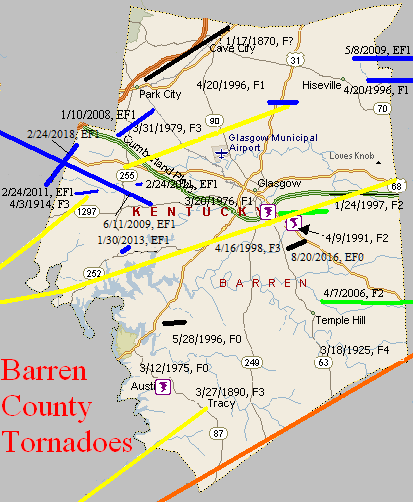
January 17, 1870
Counties: Barren
F-scale:
Deaths: 8
Injuries: 30
Path width:
Path length:
Time: 6:00am
Narrative: A tornado moved northeast from near Park City to Cave City. Fifty homes were damaged or destroyed, mostly in and near Cave City. Some of the dead were found 300 yards from where they were sleeping. The Masonic Hall and two churches were destroyed. The track may very well have continued on past Barren County.
March 27, 1890
Counties: Allen, Barren
F-scale: F3
Deaths: 4
Injuries: 25
Path width: 600 yards
Path length: 15 miles
Time: 9:00pm
Narrative: Moved northeast from five miles south of Scottsville to near Tracy. Four people were killed in Allen County as at least three homes were destroyed. Death toll may have been as high as 17.
March 18, 1925
Counties: Allen, Barren, Monroe, Metcalfe (from Sumner TN)
F-scale: F4
Deaths: 39
Injuries: 95
Path width: 400 yards
Path length: 60 miles (probably a family of tornadoes)
Time: 5:00pm
Narrative: From one of the worst tornado outbreaks ever to strike central Kentucky. This tornado moved east-northeast from near Buck Lodge, eight miles north of Gallatin. Homes were swept away in many communities, including Keytown, Angle, Oak Grove, and Liberty. As many as eight people died in one home. Trees were blown down in the steep valleys as well as on the hilltops. At least 27 people died in Tennessee. Crossing into Kentucky, the tornado struck Mt. Union (near the present-day intersection of KY 1421 and Napier Road) and then Holland, killing four. The funnel may have either weakened or lifted over southern Barren County before striking Beaumont in Metcalfe County. There it killed eight more, including five in one family. Over 150 homes were damaged or destroyed.
April 3, 1974
Counties: Simpson, Warren, Barren
F-scale: F3
Deaths: 3
Injuries: 57
Path width:
Path length:
Time: 3:45pm
Grazulis narrative: Moved northeast from west of Gold City to east of Smiths Grove. One person was killed in Simpson County at Temperance as seven homes and 40 barns were destroyed. Two people died in Warren County: one at Three Forks and one at Rocky Springs.
Noted discrepancies: SPC, NCDC, and Grazulis give a time of 3:45pm...Storm Data says 4:45pm. SPC and NCDC give a path length of 31 miles...Grazulis says 25 miles. SPC gives a path width of 10 yards...NCDC 30 yards...Grazulis nothing.
March 12, 1975
Counties: Barren
F-scale: F0
Deaths:
Injuries:
Path width:
Path length:
Time: 4:45am
Noted discrepancies: None
March 20, 1976
Counties: Barren
F-scale: F1
Deaths:
Injuries: 10
Path width:
Path length:
Time: 8:00pm
Noted discrepancies: None
March 31, 1979
Counties: Barren
F-scale: F3
Deaths: 1
Injuries: 19
Path width: 100 yards
Path length: 13 miles
Time: 4:25pm
Grazulis narrative: Moved southeast from three miles southeast of the intersection of I-65 and the Cumberland Parkway. A child was killed when a concrete block grocery store caved in. Two trailers, two cars, and ten barns were destroyed.
Noted discrepancies: SPC and NCDC rank this as an F3, Grazulis calls it an F2. SPC and NCDC give a path length of 13 miles, Grazulis gives 12 miles, Storm Data says 8 miles.
April 9, 1991
Counties: Barren
F-scale: F2
Deaths: 0
Injuries: 3
Path width: 400 yards
Path length: 1/2 mile
Time: 12:45pm
Grazulis narrative: A tornado touched down briefly two miles southeast of Glasgow "destroying" 13 trailers and 34 frame homes as well as feed mills and silos.
Noted discrepancies: None
April 20, 1996
Counties: Barren
F-scale: F1
Deaths:
Injuries: 4
Path width:
Path length:
Time: 2:30am
Noted discrepancies: None
April 20, 1996
Counties: Barren, Metcalfe
F-scale: F1
Deaths:
Injuries:
Path width:
Path length:
Time: 2:34am
Notes: Storm Data mentions damage at Queens Chapel Church and on KY 314, Spillman Road, and Thurmon-Sexton Road.
May 28, 1996
Counties: Barren
F-scale: F0
Deaths:
Injuries:
Path width:
Path length:
Time: 6:15pm
Notes: Storm Data places this tornado in Lucas.
January 24, 1997
Counties: Barren
F-scale: F2
Deaths:
Injuries:
Path width:
Path length:
Time: 5:40pm
Noted discrepancies: Storm Data lists this and the following tornado as one.
Notes: Storm Data says this tornado touched down south of Glasgow and did damage along KY 90.
April 16, 1998
Counties: Logan, Warren, Allen, Barren
F-scale: F3
Deaths: 2
Injuries: 9
Path width:
Path length: 58 miles
Time: 2:35pm
Notes: After researching this tornado (see discrepancies below), including reviewing radar data, it appears this tornado touched down at Chandlers Chapel in northeast Logan County, moving through Warren County crossing I-65 about seven and a half miles south of Bowling Green, continuing eastward into northernmost Allen County passing just north of Meador, then turning to the northeast near Finny, Haywood, three miles south of Glasgow, and ending at the Metcalfe County line near where the parkway crosses the border. The worst damage was in Barren County. Homes on Needmore School Road southwest of Haywood were extensively damaged, and a mobile home was flipped over near the intersection of Riddle Road and KY 249. In Glasgow one person was killed in his mobile home and another was killed by flying debris. In the Glasgow area one house was destroyed (F3 damage) and 45 badly damaged. Winds estimated at 175mph near Glasgow damaged or destroyed 35 mobile homes and 25 barns.
Noted discrepancies: SPC mistakenly replaces Warren County with Lawrence County. SPC gives a beginning latitude of 36.92...NCDC gives 36.95. SPC gives a path width of 100 yards, NCDC gives 200 yards. The lat/lons given for this event are all over the place. Going by the beginning lat/lon in Logan County and the ending lat/lon in Barren County, the track would go through the south side of Glasgow and would end at the Barren/Metcalfe county line, which agrees with the narrative given at NCDC. However, this path would completely miss Allen County. Storm Data has it in Logan County (Chandlers Chapel to six miles east of Chandlers Chapel), Warren County (ten miles southwest of Bowling Green to sixteen miles southeast of Bowling Green), Allen County (three miles west of Meador to two miles east of Meador), and Barren County (fourteen miles southwest of Glasgow to ten miles east of Glasgow, with Glasgow hard hit).
April 7, 2006
Counties: Barren, Metcalfe
F-scale: F2
Deaths: 0
Injuries: 4
Path width: 200 yards
Path length: 2.7 miles
Time: 4:04pm
Notes: Fifteen to twenty homes were destroyed, mainly in the Temple Hill area. Another dozen or so homes, along with barns and outbuildings, sustained heavy damage. Four people in the area were treated for minor injuries. The tornado formed about a mile northeast of Temple Hill just south of Barbour Road. Numerous trees were topped, and several homes were damaged. Most of the structural damage occurred along Moore Road, where several mobile homes were moved considerable distances and were destroyed. A large RV was flipped over...a large tractor trailer was moved about five feet...and a horse trailer was thrown over 75 yards. The tornado reached its peak intensity near the intersection of Moore Road and KY 839. The storm then crossed into Metcalfe County about three miles northeast of Nobob. Several homes and barns were destroyed on Froedge-Dubree and Pitcock roads in the Summer Shade area.
January 10, 2008
Counties: Barren
EF-scale: EF1
Deaths: 0
Injuries: 0
Path width: 350 yards
Path length: 3.1 miles
Time: 2:02pm CST to 2:06pm CST
Notes: The tornado first touched down along Millstown Road southwest of Park City. It uprooted and snapped the trunks of several large trees and did some minor roof damage to a home. The tornado was on the ground intermittently along its path to the south and east of Park City, destroying eight barns and snapping or uprooting several trees. Right before it lifted, it tore the front porch off a home and destroyed a barn.
May 8, 2009
Counties: Barren and Metcalfe
EF-scale: EF1
Deaths: 0
Injuries: 0
Path width: 30 yards
Path length: 4 miles (skipping)
Time: 3:04pm CDT - 3:11pm EDT
Notes: The tornado touched down just east of Hiseville on Buck Williams Road. A home and a small outbuilding were damaged, and numerous trees were uprooted. A piece of tin roofing ended up wrapped around a tree 500 yards to the east across an open field. The tornado peaked in intensity on a farm just north of Sexton Lane. Three outbuildings and a well-constructed barn were derstroyed. Debris from these structures was found up to 300 yards to the east in a pond. In Metcalfe County, south of Center, a pole barn was uplifted and scattered across a field.
June 11, 2009
Counties: Warren, Edmonson, Barren
EF-Scale: EF1
Deaths: 0
Injuries: 0
Path width: 150 yards
Path length: 18 miles (skipping)
Time: 7:00pm CDT
Notes: This tornado touched down along the Edmonson/Warren county line between Brownsville and Bowling Green. It moved to the east-southeast, passing just north of Smiths Grove, west of Hays, and dissipating at Beckton west of Glasgow. Many trees were snapped or uprooted, and farms in the path suffered roof and outbuilding damage. Cornfields were flattened and convergent wind signatures could be seen in the vegetation.
February 24, 2011
Counties: Barren
F-scale: EF1
Deaths: 0
Injuries: 0
Path width: 100 yards
Path length: 1 mile
Time: 10:10pm EST
Notes: Two barns destroyed, one damaged. Several trees knocked down as well.
February 24, 2011
Counties: Barren
F-scale: EF1
Deaths: 0
Injuries: 0
Path width: 100 yards
Path length: 0.25 mile
Time: 10:15pm EST
Notes: Two barns damaged.
January 30, 2013
County: Barren
EF-Scale: EF1
Deaths: 0
Injuries: 0
Path width: 50 yards
Path length: 0.3 mile
Time: 3:49am CST
Notes: A large barn was destroyed, trees were felled, and the doors and siding were pulled off of a barn along Finney Road.
May 10, 2016
County: Barren
EF-Scale: EF0
Deaths: 0
Injuries: 0
Path width: 30 yards
Path length: 1.5 miles
Time: 5:30pm - 5:33pm CDT
Notes: The tornado touched down in a corn field near Morrison Park Road, just east of Tompkinsville Road. The tornado moved east-northeast, roughly paralleling Morrison Park Road, flattening corn on several farms. Structural damage was observed on one farm, where the roof was torn off a large metal outbuilding and minor damage occurred to several other buildings as a result of this debris. Several trees were snapped or uprooted before the tornado lifted just east of Highway 90.
February 24, 2018
County: Warren, Barren
EF-Scale: EF1
Deaths: 0
Injuries: 0
Path width: 50 yards
Path length: 1.6 miles
Time: 5:19pm - 5:21pm CST
Notes: Touchdown occurred near the intersection of Hays Pondsville Road and FH Roundtree Road where a small metal shed was destroyed, a trailer was overturned, a fence was flattened, and a home suffered minor roof damage. The narrow tornado continued northeast, uprooting trees and damaging outbuildings, breaking out all of the windows of one building. It then tore the porch off the east side of a home on the south side of US 68/80, depositing debris into nearby woods. Crossing the highway the tornado did its greatest damage, tearing a very large pine tree out of the ground and tossing it 100 feet over a home, splattering the front of the home with mud, ripping holes in the roof, and destroying the attached garage. The tornado continued to snap trees and damage outbuildings on its way northeast, scattering debris a quarter mile downwind. The tornado damaged the roof of a home and did porch, deck, and roof damage to a neighboring residence, plastering the east side of the home with insulation. Crossing over Lewis Road into Barren County, the roof of a sunroom was torn off of a home and an outbuilding destroyed.


 Weather Story
 Weather Map
 Local Radar
 Follow us on YouTube