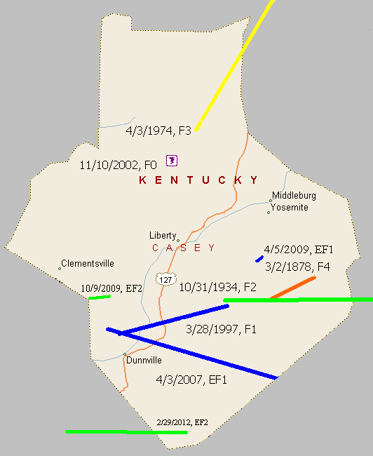
March 2, 1878
Counties: Casey
F-scale: F4
Deaths: 8
Injuries:
Path width: 400 yards
Path length:
Time: 2:30pm
Narrative: A tornado near Rich Hill and Mount Olive moved northeast and swept away dwellings, large trees, horses, cattle, and other stock. Near Rich Hill, one family of seven was killed. The mother was blown 400 yards, and her two daughters "with arms interlocked" were blown 50 yards. One other death occurred in the village of Mount Olive, where several homes were destroyed.
April 3, 1974
Counties: Casey, Lincoln, Boyle
F-scale: F3
Deaths: 1
Injuries: 98
Path width:
Path length: 18 miles
Time: 5:35pm
Grazulis narrative: Moved north-northeast from five miles southwest of Hustonville, passing through Junction City and ending at the south end of Lake Herrington northeast of Danville. Over 100 homes were severely damaged or destroyed at Junction City. Losses totalled five million dollars in Lincoln County.
Noted discrepancies: SPC and NCDC give a path length of 21 miles...Grazulis give 18 miles. SPC gives a path width of 10 yards, NCDC gives 30 yards, Grazulis doesn't know. Grazulis lists this tornado at 6:35pm.
March 28, 1997
Counties: Casey
F-scale: F1
Deaths:
Injuries:
Path width:
Path length:
Time: 7:40pm
Notes: Storm Data places this tornado near Riffe and along a ten mile long path from one mile northwest of Dunnville to Gilpin.
November 10, 2002
Counties: Casey
F-scale: F0
Deaths:
Injuries:
Path width: 25 yards
Path length:
Time: 7:30pm
Noted discrepancies: SPC lists a path width of 7 yards, NCDC 27 yards, Storm Data 25 yards.
Notes: Storm Data says this struck Peyton Ridge.
April 3, 2007
Counties: Casey
EF-scale: EF1
Deaths: 0
Injuries: 0
Path width: 200 yards
Path length: 13 miles (skipping)
Time: 8:23pm EDT
Notes: The tornado touched down four miles northwest of Dunnville and skipped along ridgetops to the east-southeast, exiting Casey County at Mintonville. The worst damage, near the upper bound of EF1 around 105 mph, was done to a well-constructed home west of Mintonville.
April 5, 2009
Counties: Casey
EF-scale: EF1
Deaths: 0
Injuries: 0
Path width: 50 yards
Path length: 1/2 mile
Time: 9:20pm EDT
Notes: One well-constructed home lost its roof, two barns were demolished, and numerous trees were felled.
October 9, 2009
Counies: Casey
EF-scale: EF2
Deaths: 0
Injuries: 0
Path width: 95 yards
Path length: 1.5 miles
Time: 2:36pm - 2:38pm EDT
Notes: Several structures were badly damaged as the tornado moved along KY 70 from Elm Drive to KY 206.
February 29, 2012
County: Russell, Casey
EF-Scale: EF-2
Deaths: 0
Injuries: 0
Path width: 150 yards
Path length: 7.2 miles
Time: 1:22pm CST
Notes: The tornado first touched down north of Russell Springs in northern Russell County west of Highway 127 where it did minor damage to trees, barns, and outbuildings. The tornado then intensified as it moved east with the worst damage occurring along a 1.5 mile stretch from Highway 76 east over Oak Grove Road to Pattie Ridge Road. On Highway 76, two mobile homes were totally destroyed and a modular home was rotated 30-80 feet counterclockwise off its foundation (with a quarter of the home blown away). Two residents survived in an underground tornado shelter where they took refuge having heard of the warning via sirens and phone calls 3-5 minutes before the tornado destroyed their homes. Residents were not home at the time of the tornado at the other homes destroyed along its path. The tornado then weakened as it moved into southern Casey County where it damaged more trees, barns, and outbuildings. The tornado finally lifted west-southwest of Windsor leaving a 7.2 mile track.


 Weather Story
 Weather Map
 Local Radar
 Follow us on YouTube