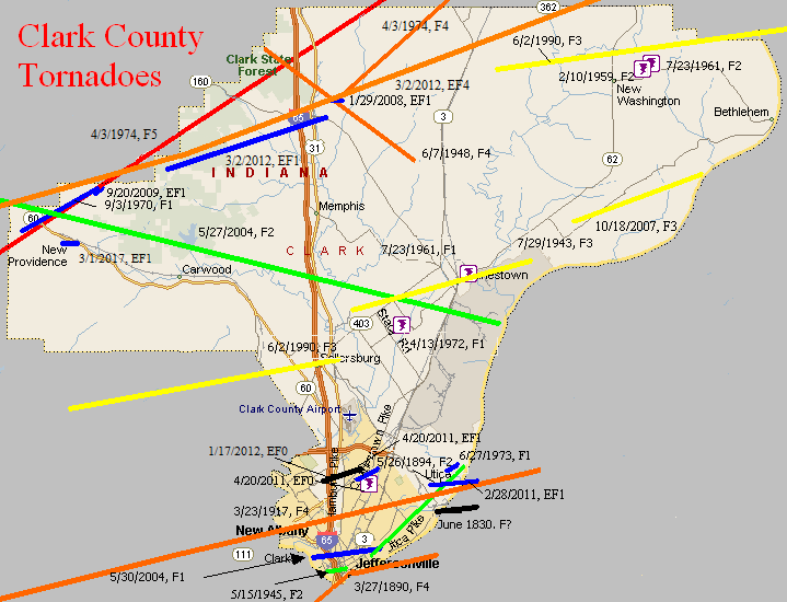
June 1830
Counties: Clark IN and Jefferson KY
F-scale:
Deaths:
Injuries:
Path width: 70 yards
Path length:
Time:
Narrative: Moved east, crossing the Ohio River about 6 miles "north" (upstream?) of Louisville, knocking down trees and fences.
March 27, 1890
Counties: Jefferson KY, Clark IN
F-scale: F4
Deaths: 76
Injuries: 200
Path width: 300 yards
Path length: 15 miles
Time: 7:57pm
Narrative: One of the most devastating tornadoes to ever strike Kentucky. This historic event may have actually started in Harrison County IN, but is traditionally plotted from west of Shively, Kentucky, in western Jefferson County. The tornado moved north-northeast and northeast through the Parkland neighborhood (Twenty-eighth and Dumesnil), leveling a few homes. This F4 damage was the only clear example of F4 strength winds along the path. However, when the tornado entered the city of Louisville it was 200 yards wide and grew to 500 yards wide as it plowed through the central business district downtown. Multi-story downtown buildings were hit by the tornado and subsequently collapsed. At least 44 deaths occurred at the Falls City Hall (1124 West Market Street). The building collapsed with 200 people inside; 75 at a lodge meeting on the upper floor and 125 children with their mothers taking dancing lessons on the lower floor. This was one of the highest tornado death totals in a single building ever recorded in the United States. Damage totalled $2.5 million (1890 dollars) in Jefferson County, with another half a million dollars with F2 intensity damage in Jeffersonville IN...along with 20 injuries. The tornado then turned to the right and re-crossed the Ohio River, coming back into Louisville dissipating near the present-day intersection of Zorn Avenue and River Road after badly damaging the city water tower. 5 churches, 7 railroad depots, 2 public halls, 3 schools, 10 tobacco warehouses, 32 manufacturing plants and 532 dwellings were destroyed by the tornado. Union Station was crushed as well. The next morning the newspaper called the storm "the whirling tiger of the air". The city organized crews of 60 men each who worked day and night searching the wreckage, along with families and friends. Sightseers started arriving the next day, and the Guard was called to control the crowds. The City refused any outside aid. The Board of Trade organized a relief committee to oversee the recovery, and the Board also authorized $15,000 in pensions to widows and orphans of the storm.
May 26, 1894
Counties: Clark IN
F-scale: F2
Deaths: 0
Injuries: 0
Path width:
Path length: 5 miles
Time:
Narrative: Moved east (northeast?) from the east edge of Jeffersonville. Barns were destroyed five miles east of town.
March 23, 1917
Counties: Harrison IN, Floyd, Clark IN, Jefferson KY
F-scale: F4
Deaths: 46
Injuries: 250
Path width: 400 yards
Path length: 33 miles
Time: 3:08pm
Narrative: One of the worst tornadoes in Kentuckiana's history. This large tornado passed one mile north of Corydon as it moved east across central Harrison County. Many farm buildings were damaged, and one farm was almost completely blown away. Its occupant was found in a ditch 200 feet from the foundation, unconscious, critically injured, and holding her unharmed baby. The twister moved east-northeast from three miles west of New Albany and cut a swath of death and destruction through the north side of town. Damage totaled $1,500,000 as 500 homes were destroyed, along with two schools and many other buildings. While many homes were swept away, the deaths were concentrated in groups, including at least five (possibly 12) deaths at the Olden Street School, eight deaths at a wood specialties plant, and five deaths in one home. Some children were killed on their way home from school. The tornado dissipated after striking Harrod's Creek, Kentucky.
Note: Grazulis counts this as two tornadoes, with a gap in the path at the Harrison/Floyd County line. More recent research by Gary Purlee and Cody Moore indicate that this was actually one tornado.
July 29, 1943
Counties: Clark, IN
F-scale: F3
Deaths: 0
Injuries: 25
Path width: 300 yards
Path length: 7 miles
Time: 7:00pm
Narrative: After damaging a farm one mile west of Charlestown, the tornado moved into the village. The twister first struck Pleasant Ridge on the southwest side of town, which was a neighborhood of pre-fab housing built for war effort employees. Sixty-five homes were unroofed, shifted, or blown apart, and seven people were badly hurt. The tornado sounded like "a dozen freight trains crossing a trestle." It then proceeded through the center of Charlestown and removed several roofs. The tornado was about three blocks wide in Charlestown. Debris could be seen in the air swirling around the funnel.
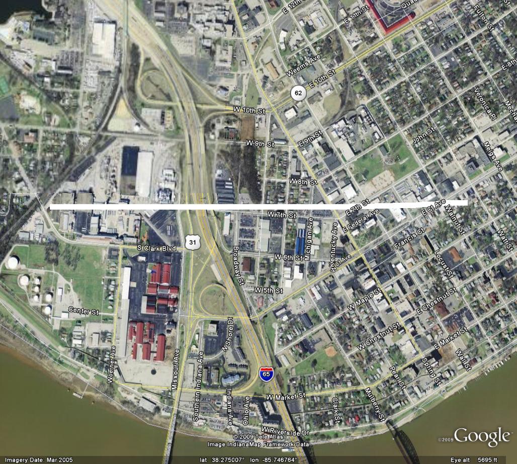
May 15, 1945
Counties: Clark, IN
F-scale: F2
Deaths: 0
Injuries: 0
Path width: 100 yards
Path length: 1/2 mile
Time: 7:45pm
Narrative: Two large factory buildings and a warehouse at the American Car and Foundry plant were destroyed in Jeffersonville, halting production of much-needed naval artillery. Slight roof damage occurred at the corner of Walnut and Court Streets. The damage was surveyed by the chief of the Louisville weather station, E. E. Unger. Click here for a close-up map of the approximate path.
June 7, 1948
Counties: Clark, IN
F-scale: F4
Deaths: 1
Injuries: 20
Path width: 100 yards
Path length: 7 miles
Time: 6:10pm
Narrative: Moved southeast along the edge of Henryville. A child was killed as a two-story hilltop home was leveled and swept away. About twenty other homes were damaged.
February 10, 1959
Counties: Clark IN
F-scale: F2
Deaths: 0
Injuries: 0
Path width:
Path length:
Time: 4:00am
Grazulis Narrative: A house and a garage were destroyed at New Washington.
Noted discrepancies: SPC gives a path length of 1/10 of a mile...NCDC and Grazulis give nothing. SPC gives a path width of 10 yards, NCDC and Grazulis give nothing. Storm Data erroneously lists this tornado in Jefferson County IN.
March 6, 1961
Counties: Clark IN
F-scale:
Deaths:
Injuries:
Path width:
Path length:
Time: 10:00am
Noted discrepancies: SPC gives a path length of 1/10 of a mile, NCDC gives nothing. SPC gives a path width of 10 yards, NCDC gives nothing. SPC and NCDC give no F-scale rating, and it's not listed in Grazulis. Storm Data says a pole barn was reduced to rubble along IN 160 northwest of Charlestown. However the lat/lon given doesn't quite agree with that location. More research is necessary.
July 23, 1961
Counties: Clark IN
F-scale: F2
Deaths: 0
Injuries: 0
Path width:
Path length:
Time: 6:30pm
Grazulis narrative: Near New Washington a small tornado leveled two barns and damaged a farm house.
Noted discrepancies: SPC gives a path length of 1/10 of a mile and a width of 10 yards...NCDC gives nothing for either.
July 23, 1961
Counties: Clark IN
F-scale: F1
Deaths:
Injuries:
Path width:
Path length:
Time: 6:30pm
Noted discrepancies: SPC gives a path length of 1/10 of a mile and a width of 10 yards...NCDC gives nothing for either.
September 3, 1970
Counties: Clark IN
F-scale: F1
Deaths:
Injuries:
Path width:
Path length:
Time: 3:30pm
Noted discrepancies: According to Storm Data this tornado touched down between Borden and Pekin just southwest of IN 60...would that be modern-day IN 160?
April 13, 1972
Counties: Clark IN
F-scale: F1
Deaths:
Injuries:
Path width:
Path length:
Time: 4:42am
Noted discrepancies: None
June 16, 1973
Counties: Clark IN
F-scale: F1
Deaths:
Injuries:
Path width:
Path length:
Time: 7:10pm
Noted discrepancies: Lat/lon actually places this in Oldham County. Listed in Storm Data in Clark County near New Washington. More research is needed.
June 27, 1973
Counties: Clark IN
F-scale: F1
Deaths:
Injuries:
Path width:
Path length:
Time: 9:00am
Notes: Six homes damaged in Utica. Tornado was described as "small, yellow, and muddy looking."
April 3, 1974
Counties: Perry, Crawford, Harrison IN, Washington IN, Clark IN, Scott IN
F-scale: F5
Deaths: 6
Injuries: 76
Path width:
Path length:
Time: 1:20pm
Grazulis narrative: Moved east-northeast and northeast from three miles south of Huffman, passing southeast of Branchville, north of Sulphur Springs and Pilot Knob, south of Sulphur and Curby, across the southeast part of DePauw, hitting two miles east of Palmyra, passing through Martinsburg, crossing the southeast half of Daisy Hill, passing between Bunker Hill and New Liberty, and ending two miles north of IN 160. This tornado immediately killed a woman as it destroyed her mobile home. As the tornado passed along southeast of Branchville it killed again. Two people, riding in a school bus, saw the tornado and took shelter in a nearby ditch. The bus was thrown fifty feet into the ditch, crushing the couple and killing the woman. Moving across Crawford County, the tornado widened to over a mile, missing many small communities and levelling several farms. In Harrison County the tornado killed a woman in her mobile home in southeast Depauw. Another woman was killed in her home two miles east of Palmyra. In the southeastern corner of Washington County the tornado struck the town of Martinsburg, destroying 38 of the town's 48 homes. Homes in the Daisy Hill area were completely swept away.
Noted discrepancies: SPC and Grazulis list 6 deaths for this tornado, NCDC lists 5. SPC lists 86 injuries, NCDC 53, Grazulis 76, Storm Data 95. SPC lists a path length of 68 miles, NCDC 50 miles, Grazulis 62 miles, Storm Data 67 miles. SPC gives a path width of 10 yards (obviously incorrect), NCDC 30 yards (obviously incorrect), Grazulis 1760 yards, Storm Data 700 yards. This tornado is split into two tornadoes at SPC. Grazulis lists an incorrect ending point for the tornado. Storm Data begins this tornado between Huffman and Tarry in Perry County and lifts it a few miles northeast of Lexington in Scott County. SPC lat/lon ends the tornado southwest of Lexington, rather than northeast. It's been mapped here according to the information in Storm Data, but additional research would be helpful.
Note: NCDC has an entry for a F5 in Clark County IN at 2:10pm that does not appear in the SPC database nor in Grazulis
April 3, 1974
Counties: Clark IN, Scott IN, Jefferson IN (to Ripley)
F-scale: F4
Deaths: 11
Injuries: 190
Path width: 1200 yards
Path length:
Time: 2:19pm
Grazulis narrative: Moved northeast from just northeast of Henryville, passing near Nabb, hitting Hanover and North Madison and the northwest edge of China, passing northwest of Canaan and ending three miles west of Cross Plains. One person was killed in Scott County. The tornado then moved into Jefferson County, heading towards Hanover. Hanover College was torn apart, sustaining ten million dollars in damage, with a few students injured. No homes were leveled there, but the tornado intensified as it passed north of Madison, and killed seven people in that area. About 300 homes were destroyed along the northern edge of Madison. Many of the homes that were leveled were the most expensive in the county. Continuing to the northeast and north-northeast the tornado killed people as it passed along the edge of China.
Noted discrepancies: NCDC doesn't list Ripley County. SPC gives a path length of 36 miles, NCDC gives 35 miles, Grazulis 38 miles. SPC and NCDC give a path width of 1200 yards, Grazulis give 800 yards.
June 2, 1990
Counties: Clark IN, Jefferson IN, Trimble
F-scale: F3
Deaths: 0
Injuries: 5
Path width:
Path length: 17 miles
Time: 9:40pm
Grazulis narrative: Moved east from near Marysville, with the funnel up to a half mile wide, just north and northeast of New Washington. The most intense damage was 200 yards wide. Many buildings, homes, and trailers were severely damaged. In Kentucky 15 homes and 25 barns were damaged in and around Mount Pleasant, with one injury. The funnel lifted northeast of Bedford.
Noted discrepancies: SPC and NCDC list a path width of 440 yards, Grazulis lists 400 yards. Ending lat/lon at SPC is over the Ohio River. NCDC does not include Trimble County. Grazulis takes it to just northeast of Bedford, which generally agree with a track map of the outbreak drawn up by NSSFC. Storm Data mentions that the tornado entered Jefferson County three miles east-northeast of New Washington and then crossed into Trimble County ending northeast of Bedford and mentions damage at Mount Pleasant as well. Will use the end point given by Storm Data and Grazulis. Grazulis times this tornado at 10:40pm.
June 2, 1990
Counties: Floyd, Clark IN
F-scale: F3
Deaths: 0
Injuries: 7
Path width: 300 yards
Path length: 12 miles
Time: 9:57pm
Grazulis narrative: Moved east-northeast from one mile northwest of Galena to Sellersburg, passing through Floyds Knobs and Hamburg. Over 25 homes and mobile homes were destroyed. A bowling alley and several businesses were damaged at Sellersburg.
Noted discrepancies: SPC gives an endpoint longitude of -85.75, NCDC gives -85.78. SPC more closely agrees with Grazulis. Grazulis lists this tornado at 10:57pm.
May 27, 2004
Counties: Washington IN, Clark IN
F-scale: F2
Deaths:
Injuries:
Path width:
Path length:
Time: 6:30pm
Notes: Storm Data takes this tornado from 6.3 miles south southwest of Salem, to Pekin, to 1.3 miles southeast of Pekin, to 2.7 miles northwest of Charlestown, to 3.1 miles southeast of Charlestown. Stacy Road and Bethany Road in the Charlestown area received damage.
May 30, 2004
Counties: Clark IN
F-scale: F1
Deaths:
Injuries:
Path width:
Path length:
Time: 2:30pm
Notes: Storm Data takes this tornado from half a mile south of Clarksville to half a mile north of Jeffersonville. It touched down at the end of Arlington Drive at the floodwall and moved east-northeast, crossing I-65 between exits one and two, then crossed Tenth Street and lifted near the end of Plaza Drive.
October 18, 2007
Counties: Clark IN
EF-scale: EF3
Deaths: 0
Injuries: 0
Path width: 440 yards
Path length: 5 miles (skipping)
Time: 10:03pm to 10:09pm EDT
Notes: Began on Bull Creek Road west of Vesta where it scoured the ground. Moving northeast, it devastated a home near Hibernia when the two-story house was blown completely off of its basement foundation and destroyed. Two large barns, a silo, and a stable were also destroyed on the same property. The tornado lifted just shy of the Ohio River near the end of Fulton Road.
January 29, 2008
Counties: Clark IN
EF-scale: EF1
Deaths: 1
Injuries: 0
Path width: 100 yards
Path length: 0.2 miles
Time: 7:58pm to 7:59pm EST
Notes: Touched down briefly just northeast of Henryville. The tornado felled trees in varying directions, one of which crashed into a mobile home killing the occupant.
September 20, 2009
County: Clark IN
EF-scale: EF1
Deaths: 0
Injuries: 0
Path width: 35 yards
Path length: 0.75 miles
Time: 5:58 - 5:59pm EDT
Notes The tornado uprooted and snapped several large trees and destroyed a small shed on Daisy Hill Road north of Borden. One snapped tree came down onto the roof of a home and did considerable damage.
February 28, 2011
Counties: Clark IN, Jefferson KY
F-scale: EF1
Deaths: 0
Injuries: 0
Path width: 100 yards
Path length: 3 miles
Time: 4:31am EST
Notes: This tornado touched down near Centennial Boulevard in Clark County. Large hardwood trees were uprooted along the tornado's path towards Utica. A house on Middle Road had a tin roof blown off and thrown 200 yards. A couple of garage doors were dented in. The tornado then crossed the Ohio River and moved into Harrods Creek. Numerous large hardwood trees were snapped in half. A section of roof was blown off a house. The tornado lifted just west of US 42.
April 20, 2011
Counties: Clark IN
EF-Scale: EF-1
Deaths: 0
Injuries: 0
Path width: 200 yards
Path length: 1.2 miles
Time: 12:28am EDT
Notes: This tornado hit about three and a half miles north northeast of Jeffersonville in Sunset Trailer Park where two dozen trailers were damaged. Several trailers were moved off of their foundations and had roof damage. One trailer roof was thrown 65 yards. Trees and power lines were damaged as well. The tornado then weakened slightly as it moved into a subdivision damaging several small trees, sheds, and roofs. A trampoline was thrown and wrapped around a shed and a tree. Continuing to the northeast, a church off of Holmans Lane suffered significant damage when its entire south wall was blown out. Sheds were destroyed and trees uprooted. Insulation was thrown from north to southeast. Across Holmans Lane trees and roofs were damaged before the tornado lifted near IN 62.
April 20, 2011
Counties: Clark IN
EF-Scale: EF-0
Deaths: 0
Injuries: 0
Path width: 75 yards
Path length: 0.1 mile
Time: 12:28am EDT
Notes: This tornado began near the previous event, on the east side of the same trailer park, and ended at Charlestown Pike. Trees were snapped, a shed was damaged, and shingle damage was found.
January 17, 2012
County: Clark IN
EF-Scale: EF0
Deaths: 0
Injuries: 0
Path width: 30 yards
Path length: 1.9 miles
Time: 11:06am EST
Notes: An EF-0 tornado first touched down at the Wal-Mart parking lot on the northwest corner of the Veteran`s Parkway near I-65. A vehicle was turned over on I-65, then the tornado skipped over an area before coming down again on a subdivision to the east, with damage occurring along Belmar Dr and Meadows Dr as well as at the intersection of Kingsfield St and Crown Ct. It took down several fences, with evidence of cyclonic circulation. It lifted again before coming down and taking the roof of a barn on Armstrong Rd.,where the tornado ended.
March 2, 2012
Counties: Washington IN, Clark IN, Scott IN, Jefferson IN, Trimble
EF-Scale: EF-4
Deaths: 11
Injuries:
Path width: 700 yards
Path length: 49 miles
Time: 2:50pm EST
Notes: Washington County: The National Weather Service in conjunction with Washington County Emergency Management conducted a detailed tornado damage survey on Saturday, March 3. Below are the results.
The tornado first touched down on the south side of Fredericksburg just south of U.S. 150 where several trees were snapped off. In this area, winds were estimated to be 90 mph (EF1) with a damage width of 30 yards along the south fork of the Blue Lick River.
Additional tree damage was observed as the tornado moved east- northeast across farmland. Near the intersection of Horners Chapel Road and Fredericksburg Road, a high tension metal power structure was toppled along with numerous trees uprooted and snapped. Here, damage was estimated as EF2 with 130 mph winds. Along Palmyra Road near Strickland Road, several trees were snapped with EF1 damage 50-100 yards wide and estimated winds of 100-110 mph. High tension wires were down and trees snapped along West End Road just north of Shanks Hill Road.
The tornado then traveled over a ridge and intensified as it hit State Route 135 at Dutch Creek Road. Here, large chunks of 5- or 6-inch thick asphalt from an approximately 4-by-4-yard section of roadway were blown 10 to 30 yards into the adjacent grass next to the road. Just east of Route 135, tremendous tree damage was observed. At this location, the tornado was estimated to be of EF3 strength with 150 mph winds. The width of the damage path also began to widen, increasing to 200 yards.
Tree and structural damage was widespread northeast of Route 135 as the tornado crossed Trainer Lane and then State Road 335 to Robbs Lane. The width of observable damage increased to one-quarter to one-third of a mile. Countless trees were snapped and uprooted. The degree of damage suggested a mix of EF2 and EF3 damage in this area, with estimated winds of 120-150 mph.
The tornado crossed U.S. 60 just south of New Pekin. Immediately east of the highway, tremendous structural damage was observed. A well-constructed and large factory building (Airgo Industries) was cleared to its foundation slab with numerous anchoring bolts bent in the direction of the storm. Debris from this building was observed one-half to three-quarters of a mile downwind. Large power poles were snapped. Another metal out building on the right periphery of the damage path had sheeting pulled off the back of the building apparently from the force of the inbound winds into the tornado. This was the area where 5 people were tragically killed in a mobile home. In this location just east of U.S. 60, damage suggested an EF4 tornado with 170 mph estimated winds, and a width of observed damage from 0.3-0.4 mile.
Damage continued to the east along and south of Hurst Road in extreme southeast Washington County. The tornado crossed into extreme northwest Clark County along and near Daisy Hill Road. In this area, a well-constructed one-story brick house at the top of a small ridge was completely destroyed with no walls standing. People onsite reported that cows were missing and could not be located. They also stated that the tornado looked like a black wall as it approached. A heavy trailer cab was blown from this house to another demolished brick home about one-quarter mile away. Damage here suggested EF4 damage with 170 mph winds.
As the tornado re-entered Washington County near the intersection of Daisy Hill Road and Williams Knob Road, widespread damage occurred. This included a home which was totally leveled as well as a couple of anchored down double wide trailers. A car was destroyed and tossed about 100 yards in the direction of storm motion from its origin at the home. At one of the destroyed trailers, a Dodge Ram pickup truck was tossed onto its side and destroyed in the opposite direction from the car (i.e., on the left side of the tornado track). Here, EF3-EF4 damage was estimated with winds of 150-170 mph. There were also snapped trees and structural damage along Whiskey Run Road. The width of the observed damage straddling the Washington-Clark County line was estimated to be one-third to one-half mile wide, although the width of the most concentrated damage was narrower. The last observed damage in Washington County was near S. Flatwood Road in a wooded area before the tornado entered Clark County.
Across Washington County, particularly east of IN 135, thousands of trees were uprooted and snapped.
Clark County and Scott County: The National Weather Service in conjunction with Clark County Emergency Management conducted an exhaustive tornado damage survey on Saturday and Sunday, March 3 and 4. Below are the results. The tornado continued east-northeast in far northwest Clark County on Dan Gray Road where the twister leveled many well-built homes and caused extensive tree damage. The tornado here was rated EF4 with estimated wind speeds of 170 mph and a damage width of one-third mile.
The tornado moved into far southeast Washington County before reappearing in Clark County. In Clark, the damage width narrowed to one-quarter mile as the tornado crossed Pixley Knob Road and decreased in intensity to EF2 with wind speeds of 115-120 mph.
Farther east, the tornado intensified again as it destroyed two double wide homes on Speith Road. One family residence on the west side of the road was severely damaged, reflecting EF3 damage with 150 mph winds.
The tornado crossed Interstate 65, damaging several vehicles and semis and closing the interstate for several hours. Several people were trapped in these vehicles, but were later rescued.
The tornado continued to strengthen just east of Exit 19 of Interstate 65 in a heavily industrialized area. Here, buildings containing several businesses were severely damaged. A home was destroyed on the east side of North Fraucke Road. The violent tornado also seriously damaged several homes on the north side of State Highway 160. Here, there was evidence of multi-vortex structure with EF4 damage and 175 mph estimated winds.
The tornado then struck the south buildings of the Henryville middle and high school complex, with severe damage and 170 mph winds (EF4). The middle school experienced the worst damage. The cafeteria was completely destroyed. Two school buses were ripped off their chassis.
There was also extensive structural damage on the east side of Henryville on North Front Street and Pennsylvania Street. A high tension tower and other homes were damaged on Pine Drive. Incredible tree damage also occurred just west of Pine Drive as the tornado traveled up a ridge. In this region, the tornado was an EF3 with 150 mph winds.
On Brownstown Road, many homes were severely damaged especially on the north side of the tornado track with estimated speeds of 150 mph (EF3). Farther east, there was massive deforestation on the east side of a ridge just west of and along Henryville Otisco Road. Several more homes were severely damaged along this road. One of these homes reflected EF4 damage and 170 mph winds.
The tornado rapidly narrowed to a rope-like structure and ended as an EF1 with 90-95 mph winds and an 80 yard wide path. This occurred near the intersection of Blackberry Trail and State Highway 3.
Simultaneously, a new cyclic tornado vortex rapidly formed from the same supercell near Mahan Road and Old State Road 3 immediately southwest of the first tornado. The second tornado began as an EF1 and damaged a church and a few trees. The vortex quickly intensified to EF3 strength as it crossed the south portion of the town of Marysville, severely damaging several homes.
East of Marysville, another cyclic vortex from the parent storm formed just southwest of the intersection of Nabb New Washington Road and Nabb Marysville Road. This vortex intensified and merged with the primary circulation. The tornado severely damaged or destroyed several houses and double wide mobile homes around the intersection of Nabb New Washington and Nabb Marysville. Debris from the double wides was tossed around a mile downwind. The tornado was rated EF3 here with 150 mph winds and a damage width of one-third mile.
A Civil Air Patrol flight on Sunday, March 4 revealed extensive ground scouring in farmers` fields east of Marysville all the way to the Jefferson-Scott County line. This scouring was evidence of a multi-vortex tornado, which was confirmed by multiple videos and photographs.
The tornado continued north of Barnes Road, damaging several clusters of trees in open country. The tornado intensified east of the intersection of Kettle Bottom and State Highway 362.
In Scott County, immediately north of Highway 362 and east of Concord Road, three homes were severely damaged while five double wide mobile homes were completely destroyed. Here, the tornado was an EF4 with 170 mph winds. Just south of 362 in Clark County, two additional homes and power poles were damaged greatly. From there, the tornado crossed into Jefferson County, Indiana.
Jefferson County: The National Weather Service in conjunction with Jefferson County, IN Emergency Management conducted the tornado damage survey in Jefferson County. The tornado traveled from Clark County, Indiana across extreme southeast Scott County and into far southern Jefferson County. Damage was observed along and just north of State Highway 362 near the 3-county line. This included several mobile homes totally destroyed, several framed houses heavily damaged, tremendous tree damage, and power poles snapped and shredded. The observed damage width was one-third of a mile with estimated winds of 170 mph (EF4).
The tornado traveled east-northeast snapping trees and power poles on County Road 850, and did its most significant damage at the intersection of Jackson Road, State Highway 62, and Swan Road about 2 miles south of the town of Chelsea.
In this area, several well-built brick homes were destroyed. The homes had anchor bolts attached to steel plates and a concrete foundation. One house was lifted and slid 65 yards off its foundation while mostly still intact. Another home was completely demolished and thrown downwind several hundred yards, within which there were 3 fatalities. The garage of this house was destroyed with one vehicle thrown 30 yards and another tossed 75 yards. A piece of farm equipment was thrown 200 yards as well. A third well-built brick home had its roof completely lifted and thrown over 300 yards downwind. Also, an above ground pool half filled with water was missing. Wind speeds in the area were estimated at 170-175 mph (EF4) with a damage width of one-quarter mile.
The tornado tracked to the north of Paynesville and south of Lee Bottom, extensively damaging forests in southern Jefferson County before crossing the Ohio River into Trimble County, Kentucky. The damage width narrowed in this area to only a couple hundred yards.
Trimble County: The National Weather Service in conjunction with Trimble County Emergency Management conducted an extensive tornado survey in Trimble County. The tornado crossed the Ohio River from Jefferson County, Indiana and narrowed to about 200 yards wide. The tornado damaged a home on Rodgers Road, overturned two barns, and uprooted and/or twisted several trees. This was consistent with EF1 damage and 105-110mph estimated winds.
At the same time a second vortex formed immediately adjacent to the first vortex and totally destroyed a barn on Rodgers Road and extensively damaged another. This tornado also damaged a lot of rugged forested area before intersecting with the path of the first vortex near the confluence of Highway 1838 (Corn Creek Road, Highway 625, and Joyce Mill Road. In this area the tornado was rated as an EF2 with 115 mph estimated winds.
Three single-wide mobile homes near the intersection of Joyce Mill Road and Highway 625 were destroyed along with tree damage and downed power lines and poles. This was consistent with EF1 damage, 105 mph estimated winds, and a damage width of 75 yards.
No evidence of further damage was observed until Rawlett Lane, where some trees were snapped and uprooted. There could have been damage in-between although the survey team was unable to access this area. The tornado then struck two homes and a single-wide mobile home on New Hope Ridge Road (Highway 2870) about 1.5 miles west of Highway 421. Here EF1 damage, 90 mph winds, and a path width of 50 yards were estimated. The tornado lifted near this location.
March 2, 2012
County: Clark IN
EF-Scale: EF1
Deaths: 0
Injuries: 0
Path width: 60 yards
Path length: 6.5 miles (skipping)
Time: 3:30pm EST
Notes: Photographs taken during a Civil Air Patrol flight corroborate interviews with residents along the damage path that there were intermittent touchdowns of a weaker tornado with the second supercell to pass over the area (see previous tornado). The second storm, which pummeled the recently devastated area with hail up to the size of softballs, followed nearly the same path as the first supercell. At least three locations along the path of this storm support the occurrence of a tornado of EF-1 intensity, with maximum winds approaching 110 mph, an intermittent path length of 6.5 miles, and a damage path width of 60 yards. The first observed damage was near Round Knob in the Clark State Forest. Damage was again observed along and west of Speith Road, 1/4 of a mile north of Henryville-Blue Lick Road just southwest of Henryville. Finally, the tornado lifted after doing damage from the south side of Henryville near Robyn Avenue to the east side of Henryville at the intersection of Highway 160 and Haddox Road.
March 1, 2017
County: Clark, IN
EF-Scale: EF1
Deaths: 0
Injuries: 0
Path width: 20 yards
Path length: 0.3 miles
Time: 6:04am - 6:05am EST
Notes: A small tornado touched down in the back yard of a home about a quarter mile west of the caution light on IN 60 in Borden and uprooted trees and caused roof damage to the home. The tornado moved along Muddy Fork and snapped or uprooted numerous trees. The tornado then crossed IN 60 where people in the Buckboard Diner witnessed it. The tornado next removed the roof of an older building next to the cafe and a garage behind the cafe. It threw the debris into a small church and removed some of its roof.


 Weather Story
 Weather Map
 Local Radar
 Follow us on YouTube