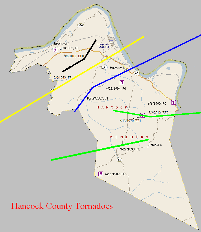
March 27, 1890
Counties: Hancock (from Daviess)
F-scale: F2
Deaths: 2
Injuries: 15
Path width:
Path length: 10 miles
Time: 7:00pm
Narrative: One of central Kentucky's darkest days began when a tornado moved northeast from south of Knottsville to north of Patesville. Two people died in homes that were destroyed.
December 9, 1952
Counties: Hancock, Perry (from Daviess)
F-scale: F3
Deaths: 0
Injuries: 3
Path width: 880 yards
Path length: 32 miles
Time: 3:00pm
Grazulis Narrative: Moved northeast, striking the northern part of Tell City. There were three homes destroyed in Kentucky, and $200,000 damage. Many barns were destroyed in Indiana, where there was $300,000 damage. Most of the Indiana damage was from wind-driven hail.
Noted discrepancies: SPC and NCDC call this an F3, Grazulis an F2. SPC and NCDC give a time of 3:00pm, Grazulis 2:30pm. SPC gives a path length of 70 miles, NCDC gives 35 miles, Grazulis gives 32 miles. SPC gives a path width of 880 yards, NCDC gives 30 yards, Grazulis says 400 yards. Grazulis mentions this was probably a family of tornadoes. NCDC or Grazulis must have the better path length...SPC entry looks to be an entry error. Storm Data says the tornado crossed from Kentucky into Indiana at Tell City with a "total path length in both states" of 32 miles.
June 13, 1970
Counties: Hancock
F-scale: F1
Deaths:
Injuries:
Path width:
Path length:
Time: 6:45am
Notes: According to Storm Data, one house was struck on Happy Hollow Road four miles south of Hawesville.
June 16, 1987
Counties: Hancock
F-scale: F0
Deaths:
Injuries:
Path width:
Path length:
Time: 6:15pm
Notes: Storm Data mentions damage at Pellsville and Roseville.
June 6, 1990
Counties: Hancock
F-scale: F0
Deaths:
Injuries:
Path width:
Path length:
Time: 2:15pm
Notes: Storm Data says this tornado struck Sunny Corner.
June 23, 1992
Counties: Hancock
F-scale: F0
Deaths:
Injuries:
Path width:
Path length:
Time: 7:05pm
Notes: Storm Data says this tornado struck near Lewisport.
April 28, 1994
Counties: Hancock
F-scale: F0
Deaths:
Injuries:
Path width:
Path length:
Time: 3:05pm
Noted discrepancies: Not listed at NCDC.
October 18, 2007
Counties: Hancock, Perry
EF-scale: EF1
Deaths: 0
Injuries: 0
Path width: 220 yards
Path length: 14 miles (skipping)
Time: 6:18pm CDT to 6:45pm CDT
Notes: This tornado touched down along the Daviess County line near Gatewood and did primarily tree and power line damage as it headed northeast. The tornado lifted slightly and passed over Hawesville as a funnel cloud (though 75 mph winds still did damage in town). The tornado came back to earth just on the other side of Cannelton and proceeded northeast into the Hoosier National Forest, damaging the Girl Scout Camp on Cann Heights Road and lifting at Plock Knob.
March 2, 2012
Counties: Hancock, Breckinridge
EF-Scale: EF-2
Deaths: 0
Injuries: 0
Path width: 200 yards
Path length: 17.4 miles
Time: 2:38pm CST
Notes: Aerial photos were matched perfectly with radar signatures to determine that the initial start point of the tornado occurred 4.5 miles south southwest of Hawesville in Hancock County along route 2181. Vinyl siding was ripped off a home and small outbuildings were damaged. The tornado continued east across route 69 toward Cloverport, intermittently touching down and doing damage to small outbuildings. 4 miles west of Cloverport, additional minor damage was done to a group of homes along 2169. Minor damage to buildings occurred just on the western outskirts of Cloverport, then the tornado lifted over the town, touching down again less than a mile east of the community, where numerous hardwood trees were observed to be uprooted from aerial photos. All of the damage was consistent with EF-0 wind speeds between 70 and 80 mph.
The National Weather Service would like to thank volunteer general aviation pilots Mark Powers and Josh Kieffer for flying the damage path in N16NA and Austin Lassell for aerial photography. The pilots are associated with the Kentuckiana Volunteer Aviators.
The tornado track continued at a residence on New Bethel Cloverport Rd. where 2 structures were destroyed. This damage is consistent with an EF-2 tornado and 110 to 115 mph winds. The tornado continued east to near B Flood road with additional structural damage consistent with EF-1 damage and 90 mph winds.
Tree damage continued along the path with additional EF-2 damage occurring at two chicken farms where a 200 yd long chicken barn was destroyed and hundreds of chickens were killed and/or lost. This is consistent with EF-2 damage and 120 mph wind. An additional smaller chicken coop also sustained damage at the end of Silas Miller Road, consistent with EF-1 damage.
The end of the path was surveyed east at Hwy 259 where another metal structure was damaged and several trees where downed. This damage was consistent with EF-1 damage and 90 mph winds.
September 8, 2018
County: Hancock
EF-Scale: EF0
Deaths: 0
Injuries: 0
Path width: 50 yards
Path length: 5 miles
Time: 4:42pm - 4:54pm CDT
Notes: This tree-top level tornado did all of its damage 20 to 30 feet above ground. Never more than 50 yards wide, the first evidence of the tornado touching down was one mile south of the water tower on Thomas Lane, where it downed several large branches that blocked the road. Moving northeast over forested land, the next evidence was more tree trunks and branches snapped on Poplar Grove Rd just north of the intersection with Hilldale Rd. The tornado then continued to skip northeast, snapping branches and trunks to the west of Frank Luttrell Rd, before crossing the road and causing minor roof damage to the metal roof of a barn and snapping more tree limbs a third of a mile southeast of North Hancock Elementary School. The tornado dropped small branches and leaves along its path as it continued northeast. The last major tree damage was observed around a home on Adair Rd, where trees were uprooted and trunks snapped in a cyclonic pattern around the home. The only damage to the home, however, was minor roof damage from a branch falling on it. The storm then crossed Adair Rd, lifting somewhere in a wooded area west of a large pond near Beauchamp Lane, where residents witnessed its dissipation.


 Weather Story
 Weather Map
 Local Radar
 Follow us on YouTube