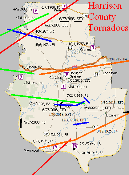
April 3, 1903
Counties: Crawford, Harrison IN
F-scale: F2
Deaths: 1
Injuries: 6
Path width:
Path length: 16 miles
Time: 1:00pm
Narrative: Moved east-northeast from near Grantsburg to northwest of Hancock. One man was killed, and his son may have died as two homes were destroyed three miles southeast of English. The tornado was said to have been "thrashing about like the tail of a mad beast".
March 23, 1917
Counties: Harrison IN, Floyd, Clark IN, Jefferson KY
F-scale: F4
Deaths: 46
Injuries: 250
Path width: 400 yards
Path length: 33 miles
Time: 3:08pm
Narrative: One of the worst tornadoes in Kentuckiana's history. This large tornado passed one mile north of Corydon as it moved east across central Harrison County. Many farm buildings were damaged, and one farm was almost completely blown away. Its occupant was found in a ditch 200 feet from the foundation, unconscious, critically injured, and holding her unharmed baby. The twister moved east-northeast from three miles west of New Albany and cut a swath of death and destruction through the north side of town. Damage totaled $1,500,000 as 500 homes were destroyed, along with two schools and many other buildings. While many homes were swept away, the deaths were concentrated in groups, including at least five (possibly 12) deaths at the Olden Street School, eight deaths at a wood specialties plant, and five deaths in one home. Some children were killed on their way home from school. The tornado dissipated after striking Harrod's Creek, Kentucky.
Note: Grazulis counts this as two tornadoes, with a gap in the path at the Harrison/Floyd County line. More recent research by Gary Purlee and Cody Moore indicate that this was actually one tornado.
March 18, 1925
Counties: Harrison IN, Jefferson KY
F-scale: F4
Deaths: 4
Injuries: 60
Path width: 1200 yards
Path length: 18 miles
Time: 5:15pm
Narrative: Moved to the east-northeast from Mauckport to just south of Louisville. Up to a mile wide, this very intense tornado swept away entire farms as it passed one mile north of Laconia and two miles south of Elizabeth. Furniture from Indiana was later found in yards in Pleasure Ridge Park, KY. The four deaths were in two separate Indiana farm homes. Jefferson County locations that were struck by the tornado or its parent thunderstorm included Orell, Greenwood Station, Kerrick Station, Blanton Station, Saint Helens, South park, Iroquois Park, and Senning's Park. The worst damage was on Eighteenth Street Road (likely today's Dixie Highway) from Lakeland to Blanton Station (the Pleasure Ridge Park/Dixie Manor Shopping Center area today). Three people were killed there. Nothing was left standing from the river to Blanton Station in a swatch two blocks wide. The twister crossed Cane Run Road and demolished a home on Greenwood Road. Damage was severe at Saint Helens, with one house completely removed except for one interior room. A two-story brick home was destroyed at Lakeland. Trees and power lines were torn down along Eighteenth Street Road from Kerrick Station to Greenwood Road...a distance of about a mile. Garages were destroyed in Senning's Park (site of Louisville's zoo at the time, located across New Cut Road from the Iroquois Amphitheater). Fifty large trees were uprooted in Iroquois Park, and smaller trees were witnessed sailing through the air. Power poles were torn down along New Cut Road. There was minor damage along Inverness Avenue northeast of Iroquois Park. A "queer greenish light" was reported before the storm hit. Hail up to 2 inches in diameter fell with the storm. The day after the storm the head of the Louisville weather service office, J. L. Kendall, surveyed the damage. he noted that the width of the tornado was 100 yards where it crossed Eighteenth Street Road, and widened to 500 yards as it entered Iroquois Park. Timber between the river and Eighteenth Street Road along Greenwood Road was observed to have been felled pointing to a common center.
March 19, 1943
Counties: Harrison, IN
F-scale: F2
Deaths: 0
Injuries: 2
Path width: 400 yards
Path length:
Time: 2:15pm
Narrative: Moved northeast at Laconia, ripping the roof and a wall off the Laconia school. Only two of the 150 students were injured.
April 27, 1971
Counties: Harrison IN
F-scale: F1
Deaths: 0
Injuries: 2
Path width: 50 yards
Path length: 15 miles
Time: 6:30pm
Grazulis narrative: Moved east from three and a half miles east of Mauckport to west of Laconia. A barn was destroyed and the debris was carried a quarter mile. Four other farm buildings were damaged. A trailer was carried 30 yards, then dropped and smashed. Two people were hospitalized. Minimal F2.
Noted discrepancies: SPC and NCDC list this as an F1, Grazulis ranks it as an F2 (albeit "minimal").
May 6, 1971
Counties: Crawford, Harrison IN
F-scale: F1
Deaths: 1
Injuries: 2
Path width:
Path length:
Time: 10:50am
Grazulis narrative: Moved east-southeast from near Milltown, passing near Depauw and Ramsey. An infant was killed and two people were injured as their trailer was destroyed. There was other F1 damage to the roofs of farm buildings and homes.
Noted discrepancies: SPC and NCDC give a time of 10:50am, Storm Data 11:50am, Grazulis 10:20am. SPC, Storm Data, and Grazulis give a path length of 8 miles, NCDC gives 9. Grazulis has this tornado touch down ten minutes before the previous one (listed above). This seems odd, since the tornadoes were moving to the southeast, and Crawford and Harrison counties are directly southeast of Knox and Daviess counties. Looking at the map it seems more logical that the Knox/Daviess tornado would be first, followed by the Crawford/Harrison tornado.
April 3, 1974
Counties: Perry, Crawford, Harrison IN, Washington IN, Clark IN, Scott IN
F-scale: F5
Deaths: 6
Injuries: 76
Path width:
Path length:
Time: 1:20pm
Grazulis narrative: Moved east-northeast and northeast from three miles south of Huffman, passing southeast of Branchville, north of Sulphur Springs and Pilot Knob, south of Sulphur and Curby, across the southeast part of DePauw, hitting two miles east of Palmyra, passing through Martinsburg, crossing the southeast half of Daisy Hill, passing between Bunker Hill and New Liberty, and ending two miles north of IN 160. This tornado immediately killed a woman as it destroyed her mobile home. As the tornado passed along southeast of Branchville it killed again. Two people, riding in a school bus, saw the tornado and took shelter in a nearby ditch. The bus was thrown fifty feet into the ditch, crushing the couple and killing the woman. Moving across Crawford County, the tornado widened to over a mile, missing many small communities and levelling several farms. In Harrison County the tornado killed a woman in her mobile home in southeast Depauw. Another woman was killed in her home two miles east of Palmyra. In the southeastern corner of Washington County the tornado struck the town of Martinsburg, destroying 38 of the town's 48 homes. Homes in the Daisy Hill area were completely swept away.
Noted discrepancies: SPC and Grazulis list 6 deaths for this tornado, NCDC lists 5. SPC lists 86 injuries, NCDC 53, Grazulis 76, Storm Data 95. SPC lists a path length of 68 miles, NCDC 50 miles, Grazulis 62 miles, Storm Data 67 miles. SPC gives a path width of 10 yards (obviously incorrect), NCDC 30 yards (obviously incorrect), Grazulis 1760 yards, Storm Data 700 yards. This tornado is split into two tornadoes at SPC. Grazulis lists an incorrect ending point for the tornado. Storm Data begins this tornado between Huffman and Tarry in Perry County and lifts it a few miles northeast of Lexington in Scott County. SPC lat/lon ends the tornado southwest of Lexington, rather than northeast. It's been mapped here according to the information in Storm Data, but additional research would be helpful.
April 3, 1974
Counties: Breckinridge, Meade, Harrison IN
F-scale: F5
Deaths: 31
Injuries: 270
Path width:
Path length: 32 miles
Time: 2:20pm
Grazulis narrative: Touching down five miles southwest of Hardinsburg, Breckinridge County, the tornado passed along the northern edge of that town, with F3 damage to homes. Thirteen people were injured and 35 homes were destroyed as the funnel moved to the northeast across Breckinridge County and into Meade County. The tornado gradually enlarged and intensified as it approached Brandenburg. The funnel devastated that town and crossed the Ohio River into Harrison County, Indiana. At Brandenburg 128 homes were completely destroyed, many of them levelled and swept away. Thirty businesses were destroyed and damage totalled over ten million dollars. There were 28 deaths in the Brandenburg area. The F4 damage occurred from north of Irvington, into Indiana.
Noted discrepancies: SPC and NCDC give a time of 2:20pm, Grazulis gives 3:25pm, Storm Data 3:30pm. SPC and NCDC give a path length of 32 miles, Grazulis gives 34. SPC and NCDC give a path width of 430 yards, Grazulis give 800 yards.
January 13, 1976
Counties: Harrison IN
F-scale: F0
Deaths:
Injuries:
Path width:
Path length:
Time: 2:50pm
Noted discrepancies: None
October 1, 1977
Counties: Harrison IN
F-scale: F1
Deaths: 1
Injuries: 1
Path width: 40 yards
Path length: 1/2 mile
Time: 7:00am
Grazulis narrative: Moved southeast, hitting a rural mobile home eight miles northeast of Corydon, blowing it apart, killing a man, and scattering debris for almost a mile. The side of a two-story home was torn off.
Noted discrepancies: SPC and NCDC list this as an F1, Grazulis says F2.
June 7, 1980
Counties: Harrison IN
F-scale: F1
Deaths:
Injuries:
Path width:
Path length:
Time: 6:30pm
Noted discrepancies: None
April 5, 1985
Counties: Harrison IN
F-scale: F2
Deaths: 0
Injuries: 0
Path width:
Path length: 1 miles
Time: 2:49pm
Grazulis narrative: A barn and a 222-foot long hog house were destroyed on separate farms, four miles north of Depauw.
Noted discrepancies: SPC and NCDC list a path width of 17 yards, Grazulis lists 20 yards, Storm Data says 33 yards.
Notes: Storm Data puts this tornado four miles north of Depauw.
July 5, 1987
Counties: Harrison IN
F-scale: F0
Deaths:
Injuries:
Path width:
Path length:
Time: 4:30pm
Noted discrepancies: None
June 2, 1990
Counties: Crawford, Harrison IN
F-scale: F2
Deaths: 0
Injuries: 9
Path width:
Path length: 11 miles
Time: 9:30pm
Grazulis narrative: Moved east-northeast from near I-64 at Riddle to five miles east-northeast of Carefree. Four homes were destroyed and several others damaged two miles north of Carefree, injuring several people. Three 400-foot-long broiler buildings were destroyed at Magnolia. The path ended at Blue River.
Noted discrepancies: SPC and Grazulis list a path width of 100 yards, NCDC lists 200 yards. Grazulis lists this tornado at 10:30pm.
June 6, 1990
Counties: Harrison IN
F-scale: F1
Deaths:
Injuries:
Path width:
Path length:
Time: 2:20pm
Notes: Storm Data says this tornado touched down just south of Corydon.
May 28, 1996
Counties: Harrison IN
F-scale: F2
Deaths:
Injuries:
Path width:
Path length:
Time: 3:55pm
Notes: Storm Data says this tornado passed one mile south of New Middletown.
July 21, 1996
Counties: Harrison IN
F-scale: F1
Deaths:
Injuries:
Path width:
Path length:
Time: 2:05pm
Notes: Storm Data puts this tornado four miles south of Corydon.
May 17, 2003
Counties: Harrison IN
F-scale: F0
Deaths:
Injuries:
Path width:
Path length:
Time: 5:30am
Notes: Storm Data takes this tornado from 1.2 miles south of New Amsterdam into New Amsterdam.
June 27, 2008
Counties: Harrison IN
EF-scale: EF0
Deaths: 0
Injuries: 0
Path width: 15 yards
Path length: 0.3 miles
Time: 7:06pm EST
Notes: A weak squall line tornado briefly touched down along IN 135, doing minor damage to several residences and downing several trees three miles northeast of Hillgrove.
June 27, 2008
Counties: Harrison IN
EF-scale: EF0
Deaths: 0
Injuries: 0
Path width: 30 yards
Path length: 0.4 miles
Time: 8:07pm EST to 8:08pm EST
Notes: A weak tornado touched down along Hancock Chapel Road Northeast, uprooting several trees in a cyclonic fashion.
June 27, 2008
Counties: Harrison IN
EF-scale: EF0
Deaths: 0
Injuries: 0
Path width: 50 yards
Path length: 0.8 miles
Time: 8:08pm EST to 8:09pm EST
Notes: This weak tornado hit the south side of a farm on Gettlefinger Road, causing a milk barn to collapse and tearing several panels off of a large metal outbuilding in addition to snapping trees in wooded areas on either side of the farm.
April 20, 2011
Counties: Harrison IN
EF-Scale: EF-0
Deaths: 0
Injuries: 0
Path width: 50 yards
Path length: 0.3 mile
Time: 12:09am EDT
Notes: Numerous hardwood and softwood trees were snapped or uprooted along the northern bank of Indian Creek two miles northeast of Corydon.
June 22, 2011
Counties: Harrison IN
EF-Scale: EF-0
Deaths: 0
Injuries: 0
Path width: 75 yards
Path length: 0.3 mile
Time: 7:27pm EDT
Notes: This tornado touched down in the 3900 block of Elizabeth-New Middletown Road. It damaged a row of trees behind a home and removed some flashing on the home. The tornado apparently lifted and crossed Elizabeth-New Middletown Road and headed east into a wooded area. The tornado snapped large limbs from the tree canopy in this area and likely was not in total contact with the ground. The tornado lasted for a minute or less.
January 30, 2013
County: Harrison IN, Jefferson KY
EF-Scale: EF0
Deaths: 0
Injuries: 0
Path width: 325 yards
Path length: 2.8 miles
Time: 4:17am EST
Notes: An NWS survey team has confirmed an EF-0 tornado touch down east of Elizabeth in Harrison County, Indiana. Four homes and two barns were damaged along Highway 111. The porch of one home was lifted and thrown 30 feet. The walls of one of the barns collapsed in multiple directions. Trees were down in this location as well. The track of the tornado extended to the Ohio River and into Jefferson County, Kentucky. Northwest of Valley Station many softwood trees were damaged, a pine tree was snapped, and a trampoline was blown over.
July 20, 2018
County: Harrison IN
EF-Scale: EF1
Deaths: 0
Injuries: 0
Path width: 250 yards
Path length: 6 miles
Time: 2:04pm - 2:20pm EDT
Notes: A National Weather Service storm survey team confirmed a maximum wind speed of 105 mph. The tornado first touched down along Justin`s Trail in the Southwind Estates subdivision. There was significant tree damage along Pleasure Ridge Road where a large tree fell on a garage. Farther east along Pleasure Ridge Road, several small funnels from the main funnel did extensive damage. A 2 x 8 impaled a concrete grain silo. At least four big barns received extensive damage, including a turkey barn. Further east, several funnels congealed into one main tornado doing extensive damage to hardwood trees and significant roof damage to several homes. Along South Pleasant Road, one home had mud spatter on the east side of the house where several pieces of wood were impaled in the ground. At that property, a pole barn was completely destroyed and thrown in different directions. A truck and horse trailer were moved 50 feet and twisted. At the end of Sarabeth Way, there was extensive hardwood tree damage which included uprooted, twisted, and mangled trees. This included several healthy hickory trees which were snapped. Further east on Sinker Road, there was impressive cyclonic crop damage across a corn field with corn laying in every direction. On Simler Road, there was consistent snapped tree damage and a camper that had been tossed and flipped over and several barns received extensive damage. During the final stages of the tornado, it struck homes along Peyton Road flipping over single wide trailers, lifting the roof of a barn, and doing extensive tree damage. Parts of the barn, including insulation and sheet metal, were thrown into the trees.
December 31, 2018
County: Harrison IN
EF-Scale: EF1
Deaths: 0
Injuries: 0
Path width: 140 yards
Path length: 2.2 miles
Time: 3:38pm - 3:41pm EST
Notes: This was an intermittent skipping tornado. A maximum wind speed of 100 mph wind was found. The tornado initially touched down at 7231 IN 337. At this location a heavy metal chain fence weighing several hundred pounds was picked up and thrown 30 yards into the back of the house causing significant damage. A chicken house weighing hundreds of pounds was rolled over and moved several feet. A purple martin house was bent over 60 degrees facing east. Shingles and yard decorations were thrown in various directions east of the house along with driveway gravel thrown in every direction. A swing set was thrown from the back of the house to the front. Throughout the property there were twisted and uprooted trees. Just before crossing the highway, the tornado increased from 75 yards to 140 yards and picked up hundreds of cornstalks tossing them in various directions across the road up to 300 yards away. Across the street at 7768 IN 337 there was significant cedar tree damage along with a 30 by 40 foot barn that was destroyed. The tornado twisted and snapped several cedar trees before going across the farmers field. The tornado narrowed and went to about 50 yards in width. At 4368 Rogers Campground Road there were several trees twisted and snapped. One single wide mobile home had siding panels blown out in several spots. An older, well built barn with sturdy cedar poles sustained significant side panel damage. The metal sheeting was thrown in a northwesterly to northeasterly direction. One 2x4 wood pole was embedded in the ground. The tornado was very narrow along Rogers Campground Road, likely no more than 50 yards wide.


 Weather Story
 Weather Map
 Local Radar
 Follow us on YouTube