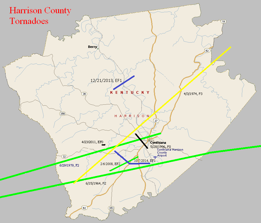
June 15, 1964
Counties: Scott KY, Harrison KY, Nicholas (and Fleming)
F-scale: F2
Deaths: 0
Injuries: 0
Path width: 30 yards
Path length: 49 miles
Time: 2:30pm
Grazulis narrative: Moved east, destroying barns and badly damaging two farm houses near Turkey Foot. This was one of a family of small tornado that skipped across three counties.
Noted discrepancies: At NCDC Scott County is listed twice and Harrison and Nicholas counties are not included. Storm Data only mentions Scott, Harrison, and Fleming counties (which doesn't make sense since Nicholas County is between Harrison and Fleming counties). The end lat/lon in the first NCDC Scott County entry is the same as the begin lat/lon in the second Scott County entry. Grazulis lists only Scott County...he does not specifically list Harrison or Nicholas...though he does mention that his Scott County tornado was "one of a family of small tornadoes that skipped across three counties" and he does mention Fleming County as being one of those three. SPC gives an ending lat/lon of 38.42/-83.73...NCDC gives 38.40/-83.93. SPC and NCDC give a path length of 49 miles, Grazulis gives one mile, Storm Data says 50 miles. SPC gives a path width of 10 yards, NCDC 30 yards, Grazulis gives nothing. Storm Data says the tornado touched down near Skinnersburg in Scott County, then lifted and touched down again at Turkey Foot in Scott County..."apparently across Harrison County", and then did damage near Flemingsburg. Should probably plot as one coherent tornado from Skinnersburg to Fleming, including all counties in between (and avoiding Bourbon County).
April 3, 1974
Counties: Harrison KY (to Robertson)
F-scale: F3
Deaths: 0
Injuries: 27
Path width:
Path length:
Time: 5:55pm
Grazulis narrative: Moved northeast from Lee's Lick to west of Cynthiana, east of Poindexter, ending near Claysville. Forty homes and 75 barns were destroyed. Near-F4.
Noted discrepancies: SPC and NCDC give a path length of 19 miles...Grazulis gives 25 miles. SPC gives a path width of 10 yards...NCDC says 30 yards...Grazulis doesn't say. Storm Data seems to only list Harrison County. Grazulis puts this tornado at 6:55pm.
June 29, 1979
Counties: Franklin, Scott KY, Harrison KY
F-scale: F2
Deaths:
Injuries: 7
Path width:
Path length:
Time: 6:00pm
Noted discrepancies: SPC and NCDC list this as an F2, Grazulis does not list it. NCDC's county-by-county lat/lons result in a very strange path. Will use more logical SPC lat/lons for plotting. Storm Data has this tornado touch down four miles north of Frankfort and moves it to Georgetown and near Cynthiana. Further research would be good, to confirm this tornado's track.
May 28, 1996
Counties: Harrison KY
F-scale: F0
Deaths:
Injuries:
Path width:
Path length:
Time: 7:20pm
Noted discrepancies: None
February 6, 2008
Counties: Harrison KY
EF-scale: EF2
Deaths: 0
Injuries: 1
Path width: 440 yards
Path length: 3.5 miles
Time: 1:29am EST to 1:34am EST
Notes: This tornado touched down near 812 Mount Vernon Road, damaging a barn and home at that location. Along Connersville Road the tornado lifted the roofs off of three homes, and damaged three others. It also destroyed several barns and outbuildings, and snapped numerous hardwood trees. It damaged a few more barns and trees before lifting about half a mile southwest of Cynthiana.
April 23, 2011
Counties: Harrison KY
EF-Scale: EF-0
Deaths: 0
Injuries: 0
Path width: 75 yards
Path length: 0.5 mile
Time: 6:09am EDT
Notes: Two dozen large trees were uprooted or snapped about two miles east of Connersville. Two large barns had pieces of tin roofing ripped off and thrown. A small garage was completely destroyed with only minor damage to its contents. Pieces of oak fencing were tossed around and two small outbuildings were damaged.
December 21, 2013
County: Harrison KY
EF-Scale: EF1
Deaths: 0
Injuries: 0
Path width:110 yards
Path length: 3.8 miles
Time: 11:29pm - 11:34pm EST
Notes: The NWS storm survey team found many areas of intermittent straight line wind damage around northern Harrison County, with one specific tornado path. There were many barns damaged or destroyed, power lines and power poles down or snapped, some trees snapped and uprooted, and several homes and outbuildings had roof damage. The most concentrated damage was along Dutch Chapel Road where about half a dozen large barns, garages, and outbuildings were either destroyed or sustained significant damage. In addition, two homes on Dutch Chapel Road had significant roof damage and other structural damage, with debris thrown to the north, northeast, and east southeast. Several residents on Dutch Chapel Road heard a distinct "freight train roar" and their ears popped, along with zero visibility during torrential rain when the storm struck.
October 7, 2014
County: Harrison, KY
EF-Scale: EF1
Deaths: 0
Injuries: 0
Path width: 275 yards
Path length: 3.9 miles
Time: 4:05pm - 4:10pm EDT
Notes: This tornado exhibited multiple vortices as it damaged or destroyed several outbuildings and barns. Significant numbers of large trees were snapped and/or uprooted as the tornado crossed US 27.


 Weather Story
 Weather Map
 Local Radar
 Follow us on YouTube