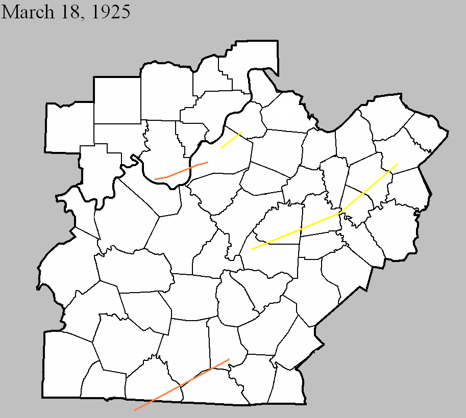
March 18, 1925
Counties: Allen, Barren, Monroe, Metcalfe (from Sumner TN)
F-scale: F4
Deaths: 39
Injuries: 95
Path width: 400 yards
Path length: 60 miles (probably a family of tornadoes)
Time: 5:00pm
Narrative: From one of the worst tornado outbreaks ever to strike central Kentucky. This tornado moved east-northeast from near Buck Lodge, eight miles north of Gallatin. Homes were swept away in many communities, including Keytown, Angle, Oak Grove, and Liberty. As many as eight people died in one home. Trees were blown down in the steep valleys as well as on the hilltops. At least 27 people died in Tennessee. Crossing into Kentucky, the tornado struck Mt. Union (near the present-day intersection of KY 1421 and Napier Road) and then Holland, killing four. The funnel may have either weakened or lifted over southern Barren County before striking Beaumont in Metcalfe County. There it killed eight more, including five in one family. Over 150 homes were damaged or destroyed.
March 18, 1925
Counties: Harrison IN, Jefferson KY
F-scale: F4
Deaths: 4
Injuries: 60
Path width: 1200 yards
Path length: 18 miles
Time: 5:15pm
Narrative: Moved to the east-northeast from Mauckport to just south of Louisville. Up to a mile wide, this very intense tornado swept away entire farms as it passed one mile north of Laconia and two miles south of Elizabeth. Furniture from Indiana was later found in yards in Pleasure Ridge Park, KY. The four deaths were in two separate Indiana farm homes. Jefferson County locations that were struck by the tornado or its parent thunderstorm included Orell, Greenwood Station, Kerrick Station, Blanton Station, Saint Helens, South park, Iroquois Park, and Senning's Park. The worst damage was on Eighteenth Street Road (likely today's Dixie Highway) from Lakeland to Blanton Station (the Pleasure Ridge Park/Dixie Manor Shopping Center area today). Three people were killed there. Nothing was left standing from the river to Blanton Station in a swatch two blocks wide. The twister crossed Cane Run Road and demolished a home on Greenwood Road. Damage was severe at Saint Helens, with one house completely removed except for one interior room. A two-story brick home was destroyed at Lakeland. Trees and power lines were torn down along Eighteenth Street Road from Kerrick Station to Greenwood Road...a distance of about a mile. Garages were destroyed in Senning's Park (site of Louisville's zoo at the time, located across New Cut Road from the Iroquois Amphitheater). Fifty large trees were uprooted in Iroquois Park, and smaller trees were witnessed sailing through the air. Power poles were torn down along New Cut Road. There was minor damage along Inverness Avenue northeast of Iroquois Park. A "queer greenish light" was reported before the storm hit. Hail up to 2 inches in diameter fell with the storm. The day after the storm the head of the Louisville weather service office, J. L. Kendall, surveyed the damage. he noted that the width of the tornado was 100 yards where it crossed Eighteenth Street Road, and widened to 500 yards as it entered Iroquois Park. Timber between the river and Eighteenth Street Road along Greenwood Road was observed to have been felled pointing to a common center.
March 18, 1925
Counties: Jefferson KY, Oldham
F-scale: F3
Deaths: 3
Injuries: 40
Path width:
Path length: 10 miles
Time: 6:00pm
Narrative: Moved northeast from the east edge of Louisville to near Pewee Valley. At least a dozen homes were destroyed. An injured person at Pewee Valley may have died several weeks later. This tornado was probably spawned from the same thunderstorm that produced the earlier tornado in southwest Louisville (see previous entry). It appears to have touched down at Hike's Point along Taylorsville Road and Brown's Lane. Barns and outhouses were levelled, roofs were blown off, and a car was overturned. The tornado moved to the northeast through present-day Saint Regis Park and Hurstbourne. The twister may have lifted briefly as it crossed Shelbyville Road very near Eight Mile House (which was unaffected). The tornado caused intermittent damage through Anchorage, and then grew in intensity and remained on the ground from O'Bannon into Pewee Valley. The twister was 1/4 mile wide as it entered Pewee Valley where it destroyed a three-story brick home and a two-story frame house. A two-story house in Pewee Valley was swept ten feet off its foundation and collapsed. Trees blocked the Louisville-Pewee Valley road for two miles. Immediately after the storm, Lagrange Interurban cars leaving Louisville could not get beyond Lyndon. Two days after the tornado the tracks were still blocked beginning at O'Bannon Station. Hail up to 2 1/4 inches in diameter pounded Crescent Hill, and the stones had large "horns" on them.
March 18, 1925
Counties: Marion, Washington KY, Mercer, Jessamine, Fayette, Bourbon
F-scale: F3
Deaths: 2
Injuries: 40
Path width: 300 yards
Path length: 60 miles (skipping)
Time: 6:30pm
Notes: What was almost certainly a family of tornadoes moved northeast from western Marion County (according to Grazulis) to 4 miles southwest of Paris in Bourbon County. This project has so far been unable to find any damage in Marion or Jessamine Counties. In Washington County many buildings across the county were leveled. The country home of Judge Case near Springfield was unroofed. The "Negro section" of Jimtown was destroyed, and all 25 houses in Jimtown were razed after the storm. In Springfield 30 people were injured and 2 were killed (the two fatalities may have been from Jimtown). Moving into Mercer County, two barns were lost on the Bond Farm. A barn was damaged and a house unroofed on the Terhune Farm, barns were blown down on the Quartz and Shelton Farms, a house and a barn were lost on the Sanford Farm, and the home of Kye Crossfield at Ebenezer was destroyed. The tornado was 1/4 mile wide in Mercer County. After possibly weakening or lifting in Jessamine County, the tornado slammed into eastern sections of Fayette County with renewed vigor. Trees were blown down on Chilesburg Road, and many trees and fences were torn down on the John E. Madden Farm on Winchester Road about four miles out of Lexington (roughly where Winchester Road meets I-75 today). The tornado reached its peak strength, high-end F3 (possibly F4) over a four-mile stretch of eastern Fayette County. About five and a half miles from Lexington on Briar Hill Road the twister devastated the Kelley Farm. Mrs. Kelley's 40-year-old "Negro hired hand" was blown 300 yards to his death. Nearly every bone in his body was broken. His right hip was dislocated to the point where it was alongside his chest. No trace of his cabin was ever found. The two-story eight-room main residence was "torn from its foundations" and reduced to a pile of rubble. The farm's chickens were stripped of their feathers. According to witnesses, the tornado was "cone-shaped and had a large black cloud at its top, coming out of the west. A pillar of flame shot skyward when the vortex of the twister struck the Kelley residence." Trees and telephone poles were blown down for a mile along Briar Hill Road. The Jonas Weil Farm on Briar Hill Road suffered an unroofed home, two miles of destroyed fence, and 500 felled trees. Moving along to the northeast, the Muir area was next in line (near the intersection of KY 1970 and KY 1973 today). William Johnson's residence on Muir Pike was "piled upon its foundations and partly blown away." The Deaver Farm was damaged, and a 15 pound rock was blown through a wall like a cannonball. Many trees were blown down. Proceeding into Bourbon County, the house of Rodes Donald had two rooms blown away, the Dudley School was moved four feet off its foundation, fifty trees were blown down on the Ewing Farm, and the Spears Farm on Stewart Road was damaged. The tornado then finally began to weaken and it dissipated about four miles shy of Paris.


 Weather Story
 Weather Map
 Local Radar
 Follow us on YouTube