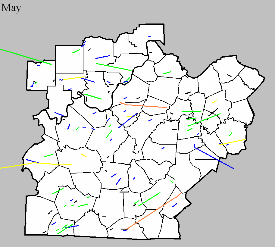
May 26, 1894
Counties: Clark
F-scale: F2
Deaths: 0
Injuries: 0
Path width:
Path length: 5 miles
Time:
Narrative: Moved east (northeast?) from the east edge of Jeffersonville. Barns were destroyed five miles east of town.
May 8, 1918
Counties: Warren
F-scale: F2
Deaths: 2
Injuries: 7
Path width:
Path length: 5 miles
Time: afternoon
Narrative: Barns or outbuildings were destroyed on eight farms. Two people died in a turnip house on the Wright Farm near Oakland. Wheat, orchard grass, strawberries, and garden crops were ruined near Smith's Grove. The Cook Hazelip Building in Smith's Grove was unroofed. Trees and telephone poles were knocked down.
May 9, 1933
Counties: Monroe, Cumberland, Adair, Russell
F-scale: F4
Deaths: 36
Injuries: 87
Path width: 800 yards
Path length: 60 miles (probably a family of tornadoes)
Time: 8:30pm
Notes: This historic event began around 8pm when there was 30 minutes of rain and hail in Tompkinsville, followed by five minutes of absolute calm. The calm was shattered when a tornado touched down just southwest of town and moved northeast, directly into southern sections the city (the "Negro section," as newspapers called it at the time). The path of utter destruction, in which everything was flattened, was a quarter mile wide. The damaged residences of O. C. Landrum and Oscar Sims marked the edges of the devastation. Between them was a treeless and fenceless waste, with scattered remnants of homes and uprooted trees. A heavy rain, which fell continuously from 1 o'clock until 6 the following morning, made roads almost impassable and handicapped the work of rehabilitation. Only three homes that were affected by the funnel were able to be salvaged. World War I veterans described the devastation and suffering as worse than what they witnessed during the Great War. The twisting nature of the winds was clearly revealed when the bodies of the Tyree family were found 75 yards south of their home site, and the bodies of the Redeford family were discovered 100 yards north of the spot where their home had stood. The Tyrees lived on the southern edge of the storm area, while the Redefords lived near the northern edge. The body of the Rev. Redeford's wife was carried 150 yards to a pond on the land belonging to L. P. Hagan. The corpse of the husband was found entangled in a barbed wire fence, having been blown about one hundred yards. Sixteen people in Tompkinsville lost their lives that evening, with another 2 deaths just northeast of town in Sewell. Fifty citizens were injured in Monroe County. After Tompkinsville, the tornado continued to the northeast, crossing Cumberland County (2 people injured) and clipping the southeast corner of Adair County (2 people killed in the Cundiff area) with comparatively little damage, before intensifying again as it entered Russell County. The tornado grew into a mile-wide monster as it plowed down at least 100 homes. The edge of the tornado missed downtown Russell Springs by only half a mile. The tornado spent its last fury in the Happy Acre area, causing damage along Goose Creek, near Friendship Church, and on the southern end of Bethany Ridge where chickens were stripped of their feathers. The tornado lifted at the Casey County line. Fatality counts for Russell County vary from 14 to 20 depending on the source...this study will use Grazulis' number of 18. Of those 18, 14 were killed on the southeast edge of Russell Springs. Up to 100 people may have been injured in Russell County.
May 9, 1933
Counties: Metcalfe, Adair
F-scale: F2
Deaths: 2
Injuries: 12
Path width: 400 yards
Path length: 15 miles
Time: 8:30pm
Narrative: Moved northeast, destroying five homes and damaging a dozen others at Columbia.
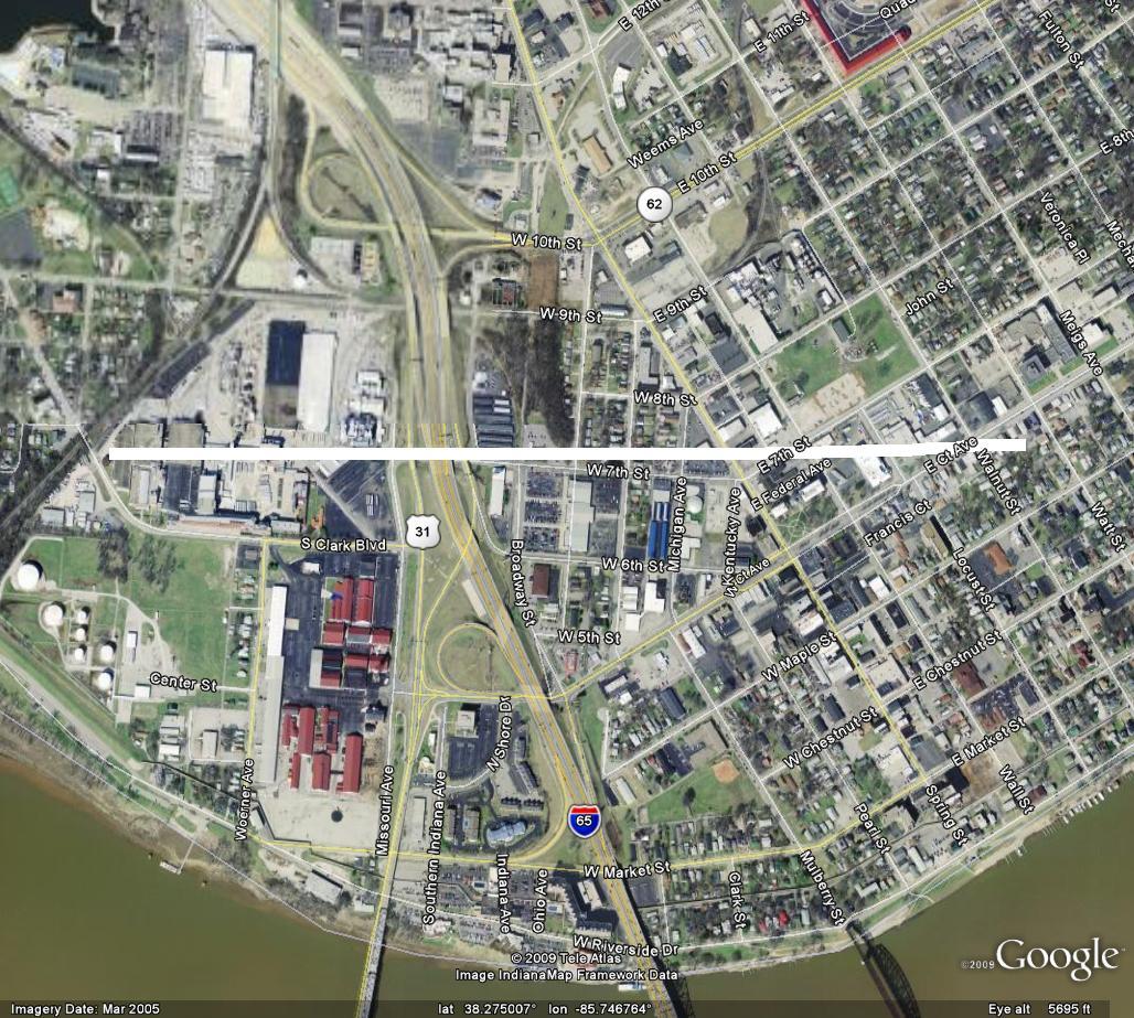
May 15, 1945
Counties: Clark, IN
F-scale: F2
Deaths: 0
Injuries: 0
Path width: 100 yards
Path length: 1/2 mile
Time: 7:45pm
Narrative: Two large factory buildings and a warehouse at the American Car and Foundry plant were destroyed in Jeffersonville, halting production of much-needed naval artillery. Slight roof damage occurred at the corner of Walnut and Court Streets. The damage was surveyed by the chief of the Louisville weather station, E. E. Unger. Click here for a close-up map of the approximate path.
May 2, 1948
Counties: Clinton (to Wayne)
F-scale: F4
Deaths: 5
Injuries: 60
Path width: 300 yards
Path length: 10 miles
Time: 7:00pm
Grazulis narrative: Moved east-northeast, leveling homes near Alpha, Sumter, and Copper. Three people were killed in a home near Alpha and two in a home near Sumter. Most of the injuries were in a church that was torn apart and collapsed during evening services.
May 2, 1954
Counties: Ohio
F-scale: F1
Deaths:
Injuries:
Path width: 25 yards
Path length:
Time: Noon
Noted discrepancies: SPC gives a path width of 10 yards, NCDC gives 30 yards, Storm Data says 25 yards.
May 7, 1961
Counties: Ohio, Grayson (from Hopkins and Muhlenberg)
F-scale: F3
Deaths:
Injuries:
Path width:
Path length:
Time: 9:25am
Grazulis narrative: Skipped east-northeast from Madisonville to Bremen, Moorman, and on to Beaver Dam. The Moorman High School gym was unroofed and a small home fell over.
Noted discrepancies: SPC and NCDC rank this as an F3, Grazulis gives it an F2. Grazulis does not include Grayson County. SPC, Storm Data, and NCDC give a time of 9:25am, Grazulis give 8:15am. SPC and NCDC give a path length of 58 miles, Grazulis give 35 miles (skipping), Storm Data gives 60 miles. SPC and NCDC give a path width of 880 yards, Storm Data says 1320 yards, Grazulis says 200 yards. This tornado is very oddly listed at the NCDC website. NCDC lists Hopkins County at 9:25am, then two entries for Muhlenberg County (one at 9:36am and the other at 9:41am), then two entries for Ohio County (one at 9:48am and the other at 9:56am), then one entry for Grayson County (at 10:17am). All entries have identical f-scale and path widths values. Storm Data begins the tornado in McLean County, and thereafter agrees with SPC. The NCDC end lat/lon of the first Muhlenberg tornado is the same as the NCDC begin lat/lon of the second. Similarly, the NCDC end lat/lon of the first Ohio tornado is the same as the NCDC begin lat/lon of the second. All lat/lons are roughly in alignment with each other and with the Grayson County lat/lons. Will plot a single tornado as close to the given lat/lons as possible. In the LMK CWFA, only Centertown and Beaver Dam (both Ohio County) are mentioned in the Storm Data narrative. More research would be nice, especially to determine if this tornado did continue into Grayson County or not.
May 26, 1965
Counties: Simpson
F-scale: F2
Deaths:
Injuries:
Path width: 100 yards
Path length:
Time: 10:15pm
Noted discrepancies: SPC and NCDC list this as an F2...Grazulis does not list it. SPC gives a path length of 1/10 of a mile...NCDC gives nothing. SPC and Storm Data give a path width of 100 yards, NCDC gives nothing.
May 14, 1967
Counties: Jessamine
F-scale: F0
Deaths:
Injuries:
Path width:
Path length:
Time: 7:00am
Noted discrepancies: SPC gives a path length of 1/10 of a mile and a width of 10 yards...NCDC gives nothing for either.
May 26, 1968
Counties: Warren
F-scale: F2
Deaths:
Injuries:
Path width:
Path length:
Time: 3:30pm
Grazulis narrative: One barn was destroyed and another was damaged at Smiths Grove.
Noted discrepancies: SPC gives a path length of 1/10 of a mile and a width of 10 yards...NCDC gives nothing for either.
May 8, 1969
Counties: Nelson
F-scale: F1
Deaths:
Injuries:
Path width:
Path length:
Time: 5:00pm
Noted discrepancies: SPC gives a path length of 1/10 of a mile and a width of 10 yards...NCDC gives nothing for either.
Notes: Storm Data says this tornado destroyed two barns in the Fairfield area.
May 8, 1969
Counties: Hart
F-scale: F1
Deaths: 0
Injuries: 1
Path width: 100 yards
Path length: 9 miles
Time: 6:15pm
Grazulis narrative: Moved northeast from three miles northeast of Horse Cave, to Uno, and on to Hardyville. Several houses and five barns were demolished. Most of the house damage was caused by falling trees.
Noted discrepancies: SPC and NCDC rank this as an F1, Grazulis gives it an F2. SPC and NCDC give it a path length of 9 miles, Grazulis and Storm Data give 8 miles. SPC and NCDC lat/lons start the tornado east of Horse Cave...Grazulis starts it northeast of Horse Cave.
Notes: Storm Data says this tornado struck three miles northeast of Horse Cave, and then to Uno and Hardyville, crossing KY 541 about two miles west of US 31E. However, KY 541 is in Breathitt County. Probably meant KY 571.
May 10, 1969
Counties: Bullitt
F-scale: F3
Deaths: 0
Injuries: 14
Path width: 300 yards
Path length: 4 miles
Time: 4:00pm EDT
Notes: (From internal Weather Bureau memo and from newspaper clippings) Eight homes destroyed, 29 damaged. Much of the tornado path was at tree top, and several residents within 1/2 mile of the storm were unaware of it due to lack of excessive winds or roar. The tornado touched down just west of the KY 480/I-65 junction, and moved east along Cedar Grove Road. The tornado did its worst damage at the beginning of its path where it demolished three homes on Dawson Drive. One lane of Interstate 65 was blocked by debris, and cars were damaged. Just east of I-65 a house trailer was lifted and deposited 100 feet away. Pieces of clothing, blankets, sheets, metal siding, and roofing were wrapped around uprooted trees and hanging from power lines. The path ended at the W.D. Miller farm. The Millers saw the vortex recede upward into the main cloud. Mr. Miller reported that a small whirlwind passed within a few hundred feet of his house, sucking out a storm window, uprooting a cedar tree, and depositing debris. Of the injured, 3 were serious enough to be hospitalized. Four-year-old Terry Harding, on Dawson Drive, suffered a fractured skull and severe head lacerations that required surgery. Timothy Dawson, 10, experienced a fractured leg. One man was sitting in his trailer when the tornado hit, and subsequently found himself sitting in a field after his trailer was carried away.
Grazulis narrative: Moved east from two miles south of Shepherdsville. Eight homes were destroyed, but some walls were left standing on all of them. Twenty-nine more homes were damaged, as were trailers, barns, and fences. One victim said that his "picture window looked as if it were breathing in and out." A car was moved from one side of a building to another.
Noted discrepancies: SPC and NCDC give a path width of 200 yards...Grazulis and Storm Data 100 yards.
May 6, 1971
Counties: Dubois (from Knox, Daviess, and Martin)
F-scale: F2
Deaths: 0
Injuries:
Path width: 50 yards
Path length: 25 miles (skipping)
Time: 9:20am
Grazulis narrative: Skipped east-southeast from east of Vincennes, passing near Hudsonville, Cumback, and Glendale. A rural school was destroyed, as was a large church and several barns. The injuries were in trailers.
Noted discrepancies: NCDC and Grazulis only list Knox and Daviess counties. The end lat/lon listed at NCDC under the Daviess County entry is actually the end lat/lon given by SPC, in Dubois County. SPC and NCDC give a time of 9:20am, Grazulis has 10:30am, and Storm Data says 10:07am. SPC and NCDC list one injury, Grazulis lists four. According to Storm Data the tornado touched down six miles south of Lawrenceville, Illinois, and then moved on to the northern and eastern edges of Vincennes, then to eleven miles southeast of Vincennes, Glendale, Monroe City, Cumback, Hudsonville, Hayesville (Dubois County), and the tornado lifted at the Purdue Research Farm near Cuzco (Dubois County).
May 6, 1971
Counties: Crawford, Harrison IN
F-scale: F1
Deaths: 1
Injuries: 2
Path width:
Path length:
Time: 10:50am
Grazulis narrative: Moved east-southeast from near Milltown, passing near Depauw and Ramsey. An infant was killed and two people were injured as their trailer was destroyed. There was other F1 damage to the roofs of farm buildings and homes.
Noted discrepancies: SPC and NCDC give a time of 10:50am, Storm Data 11:50am, Grazulis 10:20am. SPC, Storm Data, and Grazulis give a path length of 8 miles, NCDC gives 9. Grazulis has this tornado touch down ten minutes before the previous one (listed above). This seems odd, since the tornadoes were moving to the southeast, and Crawford and Harrison counties are directly southeast of Knox and Daviess counties. Looking at the map it seems more logical that the Knox/Daviess tornado would be first, followed by the Crawford/Harrison tornado.
May 6, 1971
Counties: Boyle and Lincoln (and on into Rockcastle)
F-scale: F1
Deaths: 0
Injuries: 0
Path width: 33 yards
Path length: 34 miles (skipping)
Time: 1:55pm EST
Notes: Tornado touched down on the northwest side of Danville. It initially moved south, damaging a farm south of town on Hustonville Road. A number of roofs were removed and walls blown out along the path through Danville. Boyle County Stockyards lost roofs. There was about $250,000 (1971) damage done in Danville. Funnels were sighted by the public. Winds in Danville were estimated at over 100 mph. Moving into Lincoln County, two barns were destroyed. At Stanford the sky was "filled with debris" and funnels were again sighted, along with scattered damage. The tornado then proceeded into Rockcastle County, doing additional damage at Wildie.
May 24, 1971
Counties: Simpson
F-scale: F2
Deaths:
Injuries:
Path width:
Path length:
Time: 5:35pm
Noted discrepancies: SPC/NCDC list this as an F2, Grazulis does not list it. Storm Data reports a plethora of seemingly significant damage.
May 10, 1973
Counties: Warren
F-scale: F1
Deaths:
Injuries:
Path width:
Path length:
Time: 10:45am
Grazulis narrative:
Noted discrepancies: SPC gives a path width of 10 yards, NCDC 30 yards.
Notes: Storm Data reports damage on the north side of Bowling Green.
May 25, 1973
Counties: Marion
F-scale: F1
Deaths:
Injuries: 2
Path width:
Path length:
Time: 6:00pm
Noted discrepancies: SPC gives a path width of 10 yards, NCDC 30 yards.
Notes: Storm Data locates this tornado three miles northeast of Lebanon
May 29, 1974
Counties: Jefferson KY
F-scale: F1
Deaths:
Injuries:
Path width:
Path length:
Time: 10:28pm
Noted discrepancies: None
May 12, 1978
Counties: Butler, Warren
F-scale: F2
Deaths: 0
Injuries: 0
Path width: 400 yards
Path length: 15 miles
Time: 9:45pm
Grazulis narrative: Moved east-northeast from six miles south of Morgantown near KY 79, damaging or destroying three farm homes and fifteen barns.
Notes: A home was moved off its foundation and lost a wall on "Guy Hadley" (Hadley Shearer?) Road. Trees were uprooted and a car was lifted and spun around.
Noted discrepancies: This tornado is not included in the SPC database or at the NCDC website (despite listing 32 tornadoes elsewhere across the country that day), but is listed in Storm Data and Grazulis. The Bowling Green newspaper said the damage occurred around 10:30pm.
May 30, 1979
Counties: Breckinridge
F-scale: F1
Deaths:
Injuries:
Path width:
Path length:
Time: 6:20pm
Notes: Storm Data has this tornado cross US 60, moving in a north-northeast direction. It touched down on the Brunfield Farm.
May 6, 1984
Counties: Russell
F-scale: F1
Deaths:
Injuries:
Path width:
Path length:
Time: 1:00am
Noted discrepancies: None.
May 15, 1986
Counties: Dubois
F-scale: F1
Deaths:
Injuries:
Path width:
Path length:
Time: 5:30pm
Notes: Storm Data puts this tornado at Holland.
May 22, 1989
Counties: Simpson
F-scale: F1
Deaths:
Injuries: 1
Path width:
Path length:
Time: 5:25pm
Notes: Storm Data says this tornado touched down in Middleton.
May 22, 1989
Counties: Simpson
F-scale: F2
Deaths: 0
Injuries: 0
Path width: 50 yards
Path length: 5 miles
Time: 6:50pm
Grazulis narrative: Eight homes and 22 barns were destroyed, and 13 other homes were damaged in the south part of Franklin.
Noted discrepancies: None
May 22, 1989
Counties: Monroe
F-scale: F0
Deaths:
Injuries:
Path width:
Path length:
Time: 8:15pm
Notes: Storm Data says this tornado touched down in Fountain Run.
May 26, 1989
Counties: Simpson, Allen
F-scale: F1
Deaths:
Injuries:
Path width:
Path length:
Time: 3:27pm
Notes: Storm Data says this tornado did damage on Kinnard Road, passed Gold City, and ended one mile northeast of Mount Aerial (about two miles into Allen County). Using Storm Data information plus SPC's lift-off point work well for plotting this.
May 21, 1990
Counties: Mercer
F-scale: F1
Deaths:
Injuries:
Path width:
Path length:
Time: 4:15pm
Noted discrepancies: None
May 21, 1990
Counties: Madison
F-scale: F2
Deaths: 0
Injuries: 1
Path width: 50 yards
Path length: 1/2 mile
Time: 4:45pm
Grazulis narrative: Moved east in Richmond, destroying a barn and a nightclub. A liquor store and two warehouses were unroofed.
Noted discrepancies: None
May 14, 1995
Counties: Hardin, Bullitt
F-scale: F1
Deaths: 0
Injuries: 0
Path width: 200 yards
Path length: 15 miles
Time: 12:35am
Grazulis narrative: An intermittent tornado downed and snapped trees in varying direction with "twisting" evident. One roof was damaged near Lebanon Junction.
Noted discrepancies: SPC lists this as an F2, NCDC and Grazulis list it as an F1. Storm Data says "F1 or F2". Will plot it as an F1.
May 14, 1995
Counties: Hardin
F-scale: F1
Deaths:
Injuries:
Path width:
Path length:
Time: 12:48am
Noted discrepancies: NCDC and Storm Data give no F-scale rating for this tornado.
Notes: Storm Data puts this tornado at Fort Knox.
May 14, 1995
Counties: Hardin
F-scale: F1
Deaths:
Injuries:
Path width:
Path length:
Time: 1:25pm
Notes: Storm Data puts this tornado at Cecilia.
May 14, 1995
Counties: Mercer
F-scale: F0
Deaths:
Injuries:
Path width:
Path length:
Time: 1:55am
Noted discrepancies: NCDC and Storm Data give no F-scale rating for this tornado.
Notes: Storm Data puts this tornado at Salvisa.
May 14, 1995
Counties: Franklin
F-scale: F0
Deaths: 0
Injuries: 0
Path width:
Path length: 4.5 miles (skipping)
Time: 2:00am
Notes: Though local news accounts reported "heavy damage in western Franklin County," the first specific point of damage this project has been able to find so far has been at the Capital City Airport, so will begin the track there. The tornado skipped eastward, damaging the Juniper Hills Golf Course and blowing the roof off of the Kentucky Teachers' Retirement System building on Versailles Road. It is interesting to note that if a line is drawn connecting those three damage points, the Capitol and the Governor's Mansion were in the direct path of this tornado, and the funnel cloud associated with the tornado may have gone directly over those two landmarks.
Noted discrepancies: NCDC and Storm Data give no F-scale ranking for this tornado.
May 14, 1995
Counties: Green
F-scale: F1
Deaths:
Injuries:
Path width:
Path length:
Time: 10:15pm
Notes: Storm Data puts this tornado at Donansburg.
Grazulis lists an F2 tornado in Woodford County with eight injuries, a path length of one mile, and a path width of 200 yards on May 18, 1995 at 6:35am. His narrative: "A trained spotter saw a tornado near Salvisa. Cars were blown upside-down and homes were demolished." Neither SPC nor NCDC list this tornado. Wonder if it could actually be the following event? Salvisa is in Mercer County, not Woodford.
May 18, 1995
Counties: Mercer, Woodford
F-scale: F2
Deaths: 0
Injuries: 8
Path width: 125 yards
Path length: 10 miles
Time: 7:16am-7:28am EDT
Notes from investigation in 2017: Several homes were damaged and trees uprooted as the tornado touched down. On the north side of Salvisa there was roof damage to barns and sheds along with extensive tree damage. On US 127 cars were blown off the road and damaged. Trees and power poles were snapped between Oregon and Ebenezer. Tree damage occurred near Nonesuch with F1 strength winds in southern Woodford County.
Noted discrepancies: SPC and NCDC list this as an F2, but Grazulis does not list it (which it should be, regardless of strength, as was his practice in his 1992-1995 supplement...lending support to the theory that this tornado is listed in Grazulis as the Woodford County event.) The lat/lon given for this tornado agrees with the location Grazulis gives: Salvisa, which is in Mercer County, not Woodford. Storm Data mentions the tornado location as Salvisa, but lists it under Woodford County, at 7:45am, with 6 injuries.
May 18, 1995
Counties: Mercer, Woodford, Jessamine, Fayette
F-scale: F2
Deaths: 0
Injuries: 30
Path width: 350 yards
Path length: 24 miles
Time: 7:19am-7:46am EDT
Notes from investigation in 2017: In McAfee several homes had uplifted roofs, a chimney was destroyed, and garage doors collapsed. Barns and outbuildings were destroyed. Several cars were blown off US 127, resulting in injuries. The tornado crossed into southern Woodford County just north of Mundys Landing. It damaged or destroyed eight homes with several injuries. In southwest Jessamine County at the intersection of KY 1268 and US 68 seven horses were killed along with extensive barn and fence damage. West Jessamine High School was hit around 7:36am when the tornadic wind speeds were around 145mph. Extensive structural damage was done to the school, amounting to a cost of two million dollars. There were at least 20 injuries, one critical. The tornado struck as students were arriving at school on buses. Eleven buses suffered damage and had their windows blown out. The high school roof was lifted and some top floor exterior walls collapsed. The school's tobacco barn and greenhouse were destroyed and the cattle barn was damaged. The tornado then hit a strip mall and Wal-Mart producing roof uplift and sign damage. Numerous pallets loaded with mulch and topsoil were thrown or shifted several yards. Across the county numerous power poles, barns, and homes sustained damage. The tornado weakened to F1 strength as it moved into the Tates Creek Trailer Park on the Fayette County line. There was complete destruction of roofs and walls of several single and double wide trailers. As the tornado lifted at Coletown several trees fell or were snapped.
Grazulis narrative: A tornado touched down near US 127 and moved northeast. Three houses were destroyed and five were damaged. Barns were blown down along KY 1160 near McAfee. There were also two cars damaged and eight minor injuries. A car was tossed several hundred yards.
Noted discrepancies: Grazulis times this at 6:35am. NCDC gives no beginning or ending locations for this tornado. SPC gives one point, just northeast of KY 390 northwest of Bohon.
May 18, 1995
Counties: Breckinridge
F-scale: F2
Deaths: 0
Injuries: 0
Path width: 200 yards
Path length: 1 mile
Time: 3:40pm
Grazulis narrative: Tornado damaged some homes at New Bethel. A mobile home park was damaged, as were a McDonald's roof and a Kroger roof.
Noted discrepancies: NWS ranks this as an F2, Grazulis says F1. It is not listed in Storm Data. Grazulis lists this at 4:40pm.
May 18, 1995
Counties: Metcalfe
F-scale: F0
Deaths: 0
Injuries: 0
Path width:
Path length: Less than one mile
Time: 5:04pm CDT
Notes: A state trooper spotted an F0 tornado at the Metcalfe County Fairgrounds.
Noted discrepancies: SPC gives a path length of one mile, NCDC and Storm Data say 14 miles. A path length of 14 miles would take this tornado out of Metcalfe County, so the SPC path length is used here. Storm Data only mentions damage at the fairgrounds.
May 18, 1995
Counties: Metcalfe
F-scale: F2
Deaths: 0
Injuries: 0
Path width: 200 yards
Path length: 6 miles
Time: 5:10pm CDT
Grazulis narrative: Tornado touched down in Edmonton then moved east-northeast along KY 80 to the Adair County line. A mobile home and three barns were destroyed. Several homes and a factory were damaged. Trees were blown down as well.
Noted discrepancies: Narrative given at the NCDC website and in Storm Data makes no sense.
May 18, 1995
Counties: Warren
F-scale: F2
Deaths: 0
Injuries: 0
Path width: 100 yards
Path length: 2 1/2 miles
Time: 4:25pm
Grazulis narrative: A tornado moved northeast from five miles west of Bowling Green. Homes and businesses were damaged or destroyed.
Noted discrepancies: This tornado is not listed at NCDC. However, in addition to Grazulis' information, the Bowling Green newspaper reported tornado damage on Hammett Hill Road.
May 18, 1995
Counties: Warren
F-scale: F2
Deaths: 0
Injuries: 0
Path width: 100 yards
Path length: 1 1/2 miles
Time: 4:30pm
Grazulis narrative: A tornado was intermittently on the ground near Bowling Green. Numerous homes and businesses were damaged or destroyed on the north side of Bowling Green.
Noted discrepancies: This tornado is not listed at NCDC.
May 18, 1995
Counties: Warren
F-scale: F2
Deaths: 0
Injuries: 0
Path width: 100 yards
Path length: 5 miles
Time: 4:47pm
Grazulis narrative: A tornado was intermittently on the ground about five miles east of Bowling Green. Several homes and businesses were damaged or destroyed.
Noted discrepancies: This tornado is not listed at NCDC. However, in addition to Grazulis' information, the Bowling Green newspaper reported tornado damage on Porter Pike.
May 18, 1995
Counties: Hardin
F-scale: F2
Deaths: 0
Injuries: 0
Path width: 200 yards
Path length: 1/2 mile
Time: 5:15pm
Grazulis narrative: A tornado was sighted at Fort Knox, northeast of Radcliff. Several buildings were damaged.
Noted discrepancies: NWS ranks this as an F2, Grazulis says F1. Grazulis lists this tornado at 6:15pm.
May 18, 1995
Counties: Bullitt
F-scale: F1
Deaths:
Injuries:
Path width:
Path length:
Time: 5:30pm
Noted discrepancies: SPC gives lat/lon pairs as 37.98/-85.72, 0/0...NCDC gives 37.38/-85.38, 37.35/-82.95. NCDC's lat/lons are wrong.
Notes: Storm Data places this tornado west of Shepherdsville.
May 27, 1995
Counties: Washington IN
F-scale: F0
Deaths:
Injuries:
Path width:
Path length:
Time: 9:00pm
Notes: Storm Data puts this tornado at Campbellsburg.
May 5, 1996
Counties: Washington KY
F-scale: F0
Deaths:
Injuries:
Path width:
Path length:
Time: 12:35pm
Notes: Storm Data says this tornado touched down a mile east of Willisburg.
May 5, 1996
Counties: Meade
F-scale: F1
Deaths:
Injuries: 10
Path width:
Path length:
Time: 4:05pm
Notes: Storm Data says this tornado moved from just north of Ekron to three miles southeast of Brandenburg.
May 28, 1996
Counties: Harrison IN
F-scale: F2
Deaths:
Injuries:
Path width:
Path length:
Time: 3:55pm
Notes: Storm Data says this tornado passed one mile south of New Middletown.
May 28, 1996
Counties: Dubois
F-scale: F0
Deaths:
Injuries:
Path width:
Path length:
Time: 4:40pm
Notes: Storm Data says this tornado struck the south side of Huntingburg.
May 28, 1996
Counties: Jefferson KY, Bullitt, Spencer
F-scale: F4
Deaths:
Injuries: 10
Path width:
Path length:
Time: 4:40pm
Noted discrepancies: NCDC narrative does not match up with the lat/lons given for Jefferson County.
Notes: Storm Data says this tornado formed four miles northwest of Brooks...hit Holsclaw Hill Road...Top Hill Road...near the I-65 Brooks exit...Pioneer Village...Hillview...the Northfield subdivision in Mount Washington...crossed KY 55...passed one and a half miles south of Taylorsville...near Taylorsville Lake Dam...ending just east of Little Mount.
May 28, 1996
Counties: Anderson
F-scale: F0
Deaths:
Injuries:
Path width:
Path length:
Time: 5:53pm
Notes: Storm Data mentions damage two miles southwest of Glensboro.
May 28, 1996
Counties: Anderson, Woodford
F-scale: F2
Deaths:
Injuries: 1
Path width:
Path length:
Time: 6:10pm
Noted discrepancies: SPC has no entry for fatalities...NCDC lists zero...Storm Data lists one.
Notes: Storm Data says this tornado formed near Fox Creek, moving south of Lawrenceburg...along KY 513 near the intersection of the Blue Grass Parkway and US 127...Gilbert's Creek Road...and Lillards Ferry Road in Woodford County.
May 28, 1996
Counties: Barren
F-scale: F0
Deaths:
Injuries:
Path width:
Path length:
Time: 6:15pm
Notes: Storm Data places this tornado in Lucas.
May 28, 1996
Counties: Jessamine, Fayette
F-scale: F0
Deaths:
Injuries:
Path width:
Path length:
Time: 6:42pm
Noted discrepancies: None
May 28, 1996
Counties: Harrison KY
F-scale: F0
Deaths:
Injuries:
Path width:
Path length:
Time: 7:20pm
Noted discrepancies: None
May 28, 1996
Counties: Lincoln
F-scale: F0
Deaths:
Injuries:
Path width:
Path length:
Time: 8:35pm
Notes: Storm Data says this tornado moved from McKinney to Crab Orchard.
May 13, 1998
Counties: Mercer
F-scale: F0
Deaths:
Injuries:
Path width:
Path length:
Time: Noon
Noted discrepancies: SPC lists a path width of 30 yards, NCDC says 20 yards.
Notes: Storm Data takes this tornado on a two mile long path along Gilberts Creek from Salvisa to two miles east of Salvisa. Oregon Road was blocked by felled trees from US 127 to the Kentucky River where the tornado lifted.
May 31, 1998
Counties: Adair
F-scale: F2
Deaths:
Injuries:
Path width:
Path length:
Time: 7:35pm
Notes: Storm Data takes this tornado from Pellyton to a mile southeast of Pellyton.
May 5, 1999
Counties: Logan
F-scale: F0
Deaths:
Injuries:
Path width:
Path length:
Time: 10:30pm
Notes: Storm Data says this tornado touched down in a field along KY 103 a mile north of Auburn.
May 17, 1999
Counties: Dubois
F-scale: F0
Deaths:
Injuries:
Path width:
Path length:
Time: 5:20pm
Notes: Storm Data puts this tornado in Birdseye.
May 17, 1999
Counties: Crawford
F-scale: F1
Deaths:
Injuries:
Path width:
Path length:
Time: 5:25pm
Noted discrepancies: SPC lists a path length of 1 1/2 miles...NCDC and Storm Data lists 1 mile. SPC has no listing for path width, NCDC says 73 yards, Storm Data says 50 yards.
Notes: Storm Data puts this tornado in Eckerty.
May 17, 1999
Counties: Crawford
F-scale: F1
Deaths: 0
Injuries: 0
Path width: 73 yards
Path length: 1 mile
Time: 5:30pm
Noted discrepancies: This tornado is not listed at SPC.
Notes: Storm Data puts this tornado in Eckerty.
May 23, 2000
Counties: Grayson
F-scale: F3
Deaths:
Injuries: 16
Path width:
Path length:
Time: 1:00pm
Notes: Storm Data takes this from four miles north of Leitchfield, across northeastern Leitchfield, to four miles east of Leitchfield.
May 23, 2000
Counties: Hart
F-scale: F0
Deaths:
Injuries:
Path width:
Path length:
Time: 1:25pm
Notes: SPC lists a path width of 20 yards, NCDC 27 yards, Storm Data 25 yards.
Notes: Storm Data puts this on the northwest side of Priceville.
May 23, 2000
Counties: Taylor
F-scale: F0
Deaths:
Injuries:
Path width:
Path length:
Time: 3:20pm
Noted discrepancies: SPC lists a path width of 20 yards, NCDC 27 yards, Storm Data 25 yards.
May 24, 2000
Counties: Logan
F-scale: F0
Deaths:
Injuries:
Path width:
Path length:
Time: 4:24pm
Notes: Storm Data says this tornado touched down on Liberty Church Road in Auburn.
May 24, 2000
Counties: Warren
F-scale: F0
Deaths:
Injuries:
Path width:
Path length:
Time: 6:45pm
Noted discrepancies: SPC lists a path width of 20 yards, NCDC 27 yards, Storm Data 25 yards.
May 31, 2001
Counties: Logan
F-scale: F0
Deaths:
Injuries:
Path width: 50 yards
Path length:
Time: 6:30pm
Noted discrepancies: SPC lists a path width of 17 yards, NCDC and Storm Data list 50 yards.
Notes: Storm Data says this tornado touched down two miles east of Adairsville and moved northeast for two miles.
May 8, 2003
Counties: Perry
F-scale: F1
Deaths:
Injuries:
Path width:
Path length:
Time: 7:45pm
Notes: Storm Data takes this tornado from five miles southwest of Gerald to 2.4 miles west of Rome in Hoosier National Forest.
May 8, 2003
Counties: Breckinridge
F-scale: F0
Deaths:
Injuries:
Path width:
Path length:
Time: 8:00pm
Notes: Storm Data says this tornado took place near the Ohio River from two and a half miles south of Holt to 3.8 miles southwest of Stephensport.
May 11, 2003
Counties: Hardin
F-scale: F2
Deaths:
Injuries: 5
Path width:
Path length:
Time: 3:10am
Notes: Storm Data says this tornado formed three and a half miles southwest of Rineyville on KY 1375, went through Rineyville, and lifted three miles northeast of Rineyville.
May 11, 2003
Counties: Hart
F-scale: F1
Deaths:
Injuries:
Path width:
Path length:
Time: 3:59am
Notes: Storm Data says this tornado touched down on Rowlette Street one mile west southwest of Munfordville and on KY 537, and moved northeast toward Glen Lily one mile east-northeast of Munfordville.
May 11, 2003
Counties: Mercer
F-scale: F2
Deaths: 1
Injuries: 8
Path width:
Path length:
Time: 4:30am
Notes: Storm Data says this tornado formed one and a half miles south southeast of Bohon and moved across Bohon Road near the Salt River, dissipating east of US 127 3.3 miles southeast of McAfee.
May 11, 2003
Counties: Garrard
F-scale: F1
Deaths:
Injuries:
Path width:
Path length:
Time: 5:55am
Notes: Storm Data says this tornado touched down about two miles northwest of Paint Lick near the Madison County line.
May 11, 2003
Counties: Madison
F-scale: F1
Deaths:
Injuries:
Path width:
Path length:
Time: 5:56am
Notes: Storm Data places this tornado two and a half miles west southwest of Happy Landing.
May 17, 2003
Counties: Perry
F-scale: F0
Deaths:
Injuries:
Path width:
Path length:
Time: 3:47am
Notes: Storm Data places this tornado about five and a half miles southwest of Rome in Hoosier National Forest.
May 17, 2003
Counties: Harrison IN
F-scale: F0
Deaths:
Injuries:
Path width:
Path length:
Time: 5:30am
Notes: Storm Data takes this tornado from 1.2 miles south of New Amsterdam into New Amsterdam.
May 27, 2004
Counties: Washington IN, Clark IN
F-scale: F2
Deaths:
Injuries:
Path width:
Path length:
Time: 6:30pm
Notes: Storm Data takes this tornado from 6.3 miles south southwest of Salem, to Pekin, to 1.3 miles southeast of Pekin, to 2.7 miles northwest of Charlestown, to 3.1 miles southeast of Charlestown. Stacy Road and Bethany Road in the Charlestown area received damage.
May 27, 2004
Counties: Henry
F-scale: F2
Deaths:
Injuries: 2
Path width:
Path length:
Time: 6:50pm
Notes: Storm Data takes this tornado from one mile east of Smithfield to five miles east-northeast of Eminence. It crossed KY 55 north of Eminence. It moved between US 421 and Eminence-Point Pleasant Road. It then crossed Sweeney lane.
May 27, 2004
Counties: Floyd
F-scale: F1
Deaths:
Injuries:
Path width:
Path length:
Time: 7:55pm
Notes: Storm Data takes this tornado from half a mile north of Georgetown to 2.8 miles east southeast of Georgetown. It moved nearly parallel to IN 64. It lifted near the IN 64/I-64 interchange, near Edwardsville.
May 27, 2004
Counties: Fayette
F-scale: F3
Deaths:
Injuries: 6
Path width:
Path length:
Time: 9:15pm
Notes: Storm Data takes this tornado from 4.7 miles northeast of the Lexington airport to one and a half miles southeast of Greendale. It touched down on Buck Lane, struck KY 1978, crossed Georgetown Road, and struck near Citation Boulevard.
May 30, 2004
Counties: Crawford
F-scale: F3
Deaths: 1
Injuries: 11
Path width:
Path length:
Time: 2:25pm
Notes: Storm Data takes this tornado from Taswell to two and a half miles north of Milltown. It moved north of English, struck Marengo, and went north of Milltown.
May 30, 2004
Counties: Clark IN
F-scale: F1
Deaths:
Injuries:
Path width:
Path length:
Time: 2:30pm
Notes: Storm Data takes this tornado from half a mile south of Clarksville to half a mile north of Jeffersonville. It touched down at the end of Arlington Drive at the floodwall and moved east-northeast, crossing I-65 between exits one and two, then crossed Tenth Street and lifted near the end of Plaza Drive.
May 30, 2004
Counties: Floyd
F-scale: F0
Deaths:
Injuries:
Path width:
Path length:
Time: 2:40pm
Notes: Storm Data takes this tornado from one and a half miles south of Georgetown to half a mile southeast of Edwardsville. It traveled along I-64 south of Georgetown.
May 30, 2004
Counties: Washington IN
F-scale: F1
Deaths:
Injuries:
Path width:
Path length:
Time: 3:10pm
Notes: Storm Data takes this tornado from 3.8 miles southwest of Salem to 7.2 miles east of Salem. It touched down near IN 56, crossed Beck's Mill Road, and crossed Walker Road.
May 30, 2004
Counties: Jefferson KY
F-scale: F0
Deaths:
Injuries:
Path width:
Path length:
Time: 4:27pm
Notes: Storm Data says this tornado touched down just east of Bardstown Road near the entrance to the Glenmary Subdivision and lifted on the far side of the subdivision.
May 2, 2006
Counties: Hardin
F-scale: F0
Deaths: 0
Injuries: 0
Path width: 50 yards
Path length: 0.7 miles
Time: 4:35am
Notes: Tree damage.
May 10, 2006
Counties: Dubois
F-scale: F1
Deaths: 0
Injuries: 0
Path width: 100 yards
Path length: 1.4 miles
Time: 5:49pm Central
Notes: One home received major roof damage. A workshop containing tools and heavy equipment was destroyed. Other homes received minor damage, and some outbuildings and carports were damaged. Several trees were uprooted.
May 8, 2009
Counties: Barren and Metcalfe
EF-scale: EF1
Deaths: 0
Injuries: 0
Path width: 30 yards
Path length: 4 miles (skipping)
Time: 3:04pm CDT - 3:11pm EDT
Notes: The tornado touched down just east of Hiseville on Buck Williams Road. A home and a small outbuilding were damaged, and numerous trees were uprooted. A piece of tin roofing ended up wrapped around a tree 500 yards to the east across an open field. The tornado peaked in intensity on a farm just north of Sexton Lane. Three outbuildings and a well-constructed barn were derstroyed. Debris from these structures was found up to 300 yards to the east in a pond. In Metcalfe County, south of Center, a pole barn was uplifted and scattered across a field.
May 8, 2009
Counties: Garrard and Madison
EF-scale: EF3
Deaths: 2
Injuries: several, some serious
Path width: 150 yards
Path length: 22 miles
Time: 4:55pm EDT - 5:19pm EDT
Notes: The tornado touched down in eastern Garrard County south of Nina on Bethel Road. The first damage observed was of EF1 intensity, and the tornado grew to EF2 intensity before reaching the Madison County line. The second home in the path of the tornado was badly damaged and a paper bill from the home was lifted into the tornado and carried 35 miles to the northeast into Powell County, landing in the yard of a National Weather Service employee. The tornado peaked at EF3 intensity near the intersections of KY 52 and KY 1295 in Madison County. A mobile home was picked up, thrown, and disintegrated by the tornado. Two adults were killed and thrown into a nearby pond. Five other occupants of the mobile home were injured. One person became paralyzed from the neck down, and a 4 year old child suffered a fractured skull and broken leg. The tornado then weakened and crossed the Blue Grass Army Depot, doing minor damage. The twister finally lifted near the end of Drowning Creek Road northeast of Waco.
May 2, 2010
County: Monroe
EF-scale: EF0
Deaths: 0
Injuries: 0
Path width: 50 yards
Path length: 5.7 miles
Time: 8:35am CDT
Notes: Trees and a tobacco barn were damaged.
May 21, 2010
Counties: Breckinridge, Hardin
F-scale: EF1
Deaths: 0
Injuries: 0
Path width: 75 yards
Path length: 1.75 mile
Time: 7:28pm CDT/8:28pm EDT
Narrative: A barn was significantly damaged west of Big Spring, and a mobile home was partially unroofed southeast of Big Spring. There was also some tree damage.
May 25, 2011
Counties: Dubois
EF-Scale: EF-2
Deaths: 0
Injuries: 0
Path width: 100 yards
Path length: 2 miles
Time: 9:50pm EDT
Notes: This tornado struck the southeast side of Huntingburg.
May 25, 2011
Counties: Dubois
EF-Scale: EF-1
Deaths: 0
Injuries: 0
Path width: 60 yards
Path length: 1.9 miles
Time: 9:54pm EDT
Notes: The tornado destroyed a shed when it touched down along North CR 200W west of Haysville. It snapped trees as it moved east into Haysville. One home was unroofed, at the corner of North Church Street and West Haysville Road.
May 25, 2011
Counties: Orange
EF-Scale: EF-2
Deaths: 0
Injuries: 0
Path width: 230 yards
Path length: 4.7 miles
Time: 10:22pm EDT
Notes: The tornado began along IN 37 where it uprooted and snapped several trees. It expanded to its maximum width and strength about a mile into its path. At that point it heavily damaged two brick homes and one wood frame home as well as destroying a wood barn (overturning the tractor inside) and two metal outbuildings. The tornado continued to the northeast damaging another outbuilding and uprooting and snapping numerous trees before lifting.
May 25, 2011
Counties: Orange, (Lawrence), Washington IN
EF-Scale: EF-1
Deaths: 0
Injuries: 0
Path width: 150 yards
Path length: 3.2 miles
Time: 10:28pm EDT
Notes: After touching down and destroying a large wood barn the tornado moved to the northeast over farmland, snapping and uprooting numerous trees. It continued through the extreme southeast corner of Lawrence County and entered Washington County before dissipating at Spangler Hill Road.
May 25, 2011
Counties: Washington IN
EF-Scale: EF-1
Deaths: 0
Injuries: 0
Path width: 130 yards
Path length: 2.8 miles
Time: 10:31pm EDT
Notes: This tornado snapped and uprooted numerous trees along its path and heavily damaged a metal outbuilding on North Spangler Hill Road before dissipating near the intersection of North Spangler Hill Road and North White River Road.
May 1, 2012
County: Trimble
EF-Scale: EF0
Deaths: 0
Injuries: 0
Path width: 15 yards
Path length: 1.9 miles
Time: 4:45pm EDT
Notes: This weak tornado did tree damage as it briefly touched down along Mount Pleasant Road northwest of Bedford, snapping upper-level tree branches in a narrow path. Occupants of a mobile home witnessed the tornado as it approached from the west, and they took shelter in their bathroom. While a large tree next to their home crushed a pickup truck as it came down, their home sustained minimal damage.
May 14, 2014
County: Bullitt
EF-Scale: EF0
Deaths: 0
Injuries: 0
Path width: 50 yards
Path length: 1.5 miles
Time: 2:23pm EDT
Notes: An EF-0 tornado with estimated winds between 65 and 80 mph touched down southeast of Shepherdsville and snapped a tree at a residence along Lotus Street. It then moved northeast and removed several shingles from another home along this same street. Several large branches were downed near this home as well. Several trees were also toppled in a wooded area behind this home. A neighbor along Deatsville Road had a tree fall and crush a trampoline. Farther north along Deatsville Road, a resident lost a large section of a tree and had minor siding damage along the east side of his home. A mile farther to the northeast, just before lifting, the tornado sheared off a portion of a row of trees adjacent to Maraman Road.
May 10, 2016
County: Breckinridge
EF-Scale: EF1
Deaths: 0
Injuries: 0
Path width: 25 yards
Path length: 0.4 mile
Time: 2:22pm - 2:23pm CDT
Notes: A very narrow and intense damage path of rotating winds of 90-95 mph was embedded within a 3-mile wide area of straight-line winds. The tornado left a distinct path in the vegetation and destroyed a part of a large metal barn near the Rosetta General Store. It also caused the walls of 2 adjacent outbuildings and a garage to buckle out.
May 10, 2016
County: Ohio
EF-Scale: EF2
Deaths: 0
Injuries: 0
Path width: 300 yards
Path length: 8.6 miles
Time: 6:06pm - 6:21pm CDT
Notes: This tornado briefly touched down on Spinks Drive just off of Highway 69. The tornado was only on the ground for approximately 200 yards with a path width of about 30-40 yards. A basement crawl space door was blown out along with siding and roof damage at 125 Spinks Drive. The tornado touched down for a second time at 41 El Retiro Ln where the path width increased to 50 yards and the winds speed increased to 90-95mph. Numerous large hardwood trees were snapped and twisted. An outbuilding, previously used to make brooms, next to the house had significant damage when a large tree fell on top of it. The tornado increased in size at 532 Stoneridge Ln. A custom-built home had exterior wall damage in the master bedroom with adjacent bathroom. Blow-in insulation blew out in all directions in the house and the back porch resembled a snow globe. Numerous trees and a grain silo were down along the property. The family survived the tornado by sheltering in a 3-foot crawl space. Winds in this area were 110 mph with a path width about 125 yards. The tornado continued to move east northeast along the countryside uprooting, twisting, and damaging numerous hardwood trees. The tornado significantly increased in width to approximately 300 yards and did a lot of damage along Halls Creek Rd. At 1130 Halls Creed Road 2-inch hail occurred before the tornado, with winds of 111 mph. Significant damage was done to the property, which included a 30x50 barn sliding the wall 12 feet. Along Walnut Rd, the tornado caused damage to several barns and numerous softwood trees and hardwood trees. Metal sheeting from barns was thrown in excess of 400 yards downwind. At the intersection of Highway 1164 and 1544 at the Cedar Grove Church there was roof damage to the church and many trees were twisted and uprooted. The last visible damage was along Highway 1544 just east of 1164 with some trees uprooted and twisted. About 30 feet from the tree there was an outbuilding that had half its roof blown off and the roof remnants were found about 50 yards away. The tornado ended approximately 400 yards from Highway 1544 near the intersection of 1164.
May 19, 2017
County: Crawford
EF-Scale: EF1
Deaths: 0
Injuries: 0
Path width: 50 yards
Path length: 0.2 mile
Time: 4:22pm - 4:24pm EDT
Notes: Damage with this tornado occurred along Old Union Chapel Road of IN 62 near T&T Auto. The tornado formed in pasture southwest of the road and then knocked over several cedar trees and split several sections on some maple trees before striking a barn. 85 mph winds. The barn suffered roof and door damage. Debris was thrown 125 yards downwind into the auto body shop vehicle lot. Several vehicle windows were smashed. 90 mph winds. A single-wide trailer experienced roof damage above its entrance. An old RV had its roof removed and large sections of debris were thrown about 100 yards. The unattached bed of a pickup truck was picked up and thrown 150 yards. Another RV was tipped over onto its side. 85 mph winds. The auto body shop suffered roof damage. Three trees were knocked down or snapped northeast of the shop, with the last evidence of a tornado about 150 yards farther down. Several witnesses observed the tornado and it was captured on video.
May 20, 2017
County: Jefferson, IN
EF-Scale: EF1
Deaths: 0
Injuries: 0
Path width: 30 yards
Path length: 0.2 mile
Time: 7:10pm - 7:11pm EDT
Notes: Touchdown was just north of West Galway Trail North in a tree line behind some houses. The tornado uprooted and snapped trees as it moved east. An eyewitness reported seeing a black mass with debris moving horizontally. The tornado covered the witness's house in fallen trees. As it crossed Paper Mill Road the inflow winds into the tornado pulled off siding from nearby houses and moved light objects several hundred feet. A camper parked on the southern edge of the path rolled three times toward the center of the circulation and was destroyed. After crossing the road the tornado struck an abandoned farm house and did more tree damage.
May 3, 2021
County: Monroe
EF-Scale: EF1
Deaths: 0
Injuries: 0
Path width: 60 yards
Path length: 0.5 mi
Time: 8:08am CDT
Notes: The tornado touched down near the intersection of Second and Jackson Streets in Tompkinsville. Trees were laying in multiple directions and most of the trees were twisted, snapped, or uprooted. Power lines were down and several power poles were snapped. Winds at this location were between 85 and 90 mph with a width of 50 yards. Between Fifth Street and Carter Street the wind speeds increased to 95 mph and the width expanded to 60 yards. Several homes experienced roof damage with some windows blown out. One home had multiple large trees uprooted with an RV trailer and pontoon boat flipped over. There were several pieces of lumber that were impaled in the ground and pieces of metal sheeting were thrown into trees. The US Bank building at the corner of Fifth and Main had some roof damage. The tornado then lifted briefly before touching back down near the intersection of Pedigo and White Streets. There was significant tree damage east of Main Street near Pedigo Street, Trees were facing multiple directions and there was mud spatter on the backside of homes and vehicles along Short Street to Monroe Drive. Multiple power lines were down in this area as well. Winds were about 90 mph along Monroe Drive. There was minor tree damage near Spring Valley Road and Woodhaven Drive indicating wind speeds of 85 mph. The tornado completely lifted at Jackie Crow salvage yard with debris thrown on the top of the hill about 250 yards from the salvage yard.


 Weather Story
 Weather Map
 Local Radar
 Follow us on YouTube