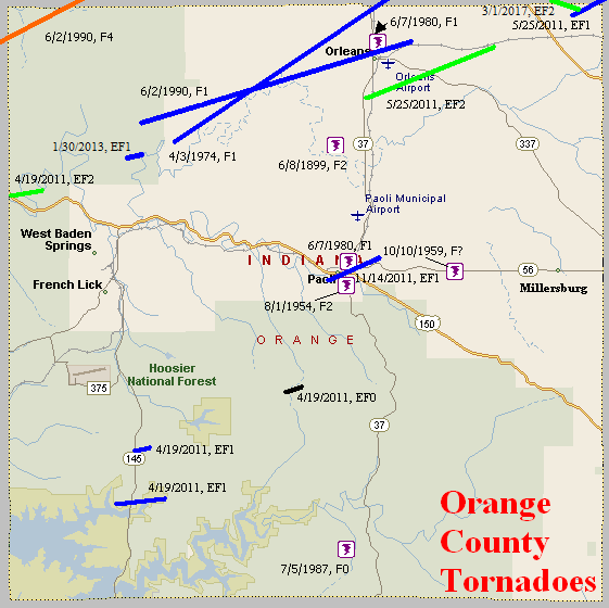
June 8, 1899
Counties: Orange
F-scale: F2
Deaths:
Injuries:
Path width:
Path length:
Time:
Narrative: Timber and barns were destroyed four miles north of Paoli.
August 1, 1954
Counties: Orange
F-scale: F2
Deaths:
Injuries:
Path width:
Path length:
Time: Noon
Noted discrepancies: SPC and NCDC list this as an F2, Grazulis does not list it. SPC gives a path length of 1/10 of a mile, NCDC gives nothing. SPC gives a path width of 10 yards, NCDC gives nothing.
October 10, 1959
Counties: Orange
F-scale:
Deaths:
Injuries:
Path width:
Path length:
Time: 11:15pm
Noted discrepancies: SPC gives a path length of 1/10 of a mile...NCDC gives nothing. SPC gives a path width of 10 yards, NCDC gives nothing. The lack of an F-scale is frustrating. Storm Data mentions that the tornado was small and the worst damage seems to have been the destruction of a barn. It also apparently hit a cemetery and "toppled 50 tombstones". It struck on IN 56 midway between Paoli and Millersburg. Would guess it was an F1, but more research is needed to get a better idea of this tornado's f-scale.
April 3, 1974
Counties: Orange (to Lawrence)
F-scale: F1
Deaths:
Injuries:
Path width:
Path length:
Time: 1:15pm
Noted discrepancies: NCDC only lists Orange County, but the NCDC liftoff lat/lon is in Lawrence County. Storm Data seems only to list Lawrence County, with the tornado hitting form the junction of US 50 and IN 235 to just north of Freetown. More research is needed.
June 7, 1980
Counties: Orange
F-scale: F1
Deaths: 0
Injuries: 0
Path width:
Path length:
Time: 6:00pm
Notes: This tornado touched down in or near Paoli.
June 7, 1980
Counties: Orange
F-scale: F1
Deaths:
Injuries:
Path width:
Path length:
Time: 6:00pm
Noted discrepancies: This tornado blew down a barn on the north side of Orleans.
July 5, 1987
Counties: Orange
F-scale: F0
Deaths:
Injuries:
Path width:
Path length:
Time: 4:30pm
Noted discrepancies: None
June 2, 1990
Counties: Orange (from Martin, to Lawrence)
F-scale: F4
Deaths:
Injuries:
Path width:
Path length:
Time: 6:29pm
Grazulis narrative: Grazulis gives a lengthy description of this tornado, but does not give any information about Orange County, most likely since the tornado just barely clipped the corner of the county and went through an extremely rural, wooded area that is virtually unpopulated.
Noted discrepancies: Only Martin, Orange, and Lawrence are listed in this SPC entry. Grazulis has an event that starts in Illinois at 5:20pm and crosses into Indiana as a 110-mile long tornado family path. Grazulis lists Hamilton, Wayne, Edwards, Wabash IL, Knox, Gibson, Pike, Daviess, Martin, Orange, and Lawrence IN (note the last three match the SPC entry). NCDC lists Hamilton County Illinois with an F4 at 5:20pm, agreeing perfectly with Grazulis. Along Grazulis' path at NCDC, Wayne County Illinois is listed as an F4 at 5:24pm, Edwards County Illinois as an F4 at 5:49pm, Wabash County Illinois as an F4 at 6:08pm, Knox County Indiana as an F4 at 6:29pm, Gibson County Indiana as an F4 at 6:39pm, Pike County Indiana as an F4 at 6:48pm, Daviess County Indiana as an F4 at 7:08pm, Martin County Indiana as an F4 at 7:24pm, Orange County Indiana as an F4 at 7:41pm, and Lawrence County Indiana as an F4 at 7:43pm. Strange time disagreement between SPC and NCDC.
Notes: Grazulis/NCDC seem more believable here. Grazulis/NCDC information agrees well with a track map of the outbreak drawn up by NSSFC. Storm Data says this tornado entered Orange County three miles south-southwest of Huron and entered Lawrence County three miles south-southeast of Huron. Will plot in Orange County according to the Storm Data description. Further research would be nice, to see what it did in Orange County, though it went through a rather desolate area in Hoosier National Forest.
June 2, 1990
Counties: Orange
F-scale: F1
Deaths:
Injuries:
Path width:
Path length:
Time: 7:54pm
Notes: Storm Data says this tornado struck Orangeville and Orleans.
April 19, 2011
Counties: Orange
EF-Scale: EF-2
Deaths: 0
Injuries: 0
Path width: 200 yards
Path length: 1 mile
Time: 11:39pm EDT
Notes: This tornado began on the county line near Roland, then crossed US 150 into Roland and onto CR 275N. Numerous trees were uprooted and snapped in a convergent pattern. In one concentrated spot two dozen trees were snapped off. A house had its windows blown in on its southwest side. A well constructed log cabin lost shingles. A very well constructed large barn had its metal roofing torn off and wrapped into tree tops up to 200 yards downwind. A wood shed was destroyed.
April 19, 2011
Counties: Orange
EF-Scale: EF-1
Deaths: 0
Injuries: 0
Path width: 125 yards
Path length: 1.5 miles
Time: 11:40pm EDT
Notes: The tornado touched down 7.7 miles south of French Lick just west of Tony's Marina near IN 145. Trees were uprooted and snapped. A large metal barn with cinder block walls was destroyed. The tornado then crossed IN 145 and moved into the marina. Three metal outbuildings were damaged or destroyed. One of the buildings had its doors blown in, on another the metal roof was peeled back, and the third was leveled and blown 300 yards downwind. Trees were uprooted in a convergent pattern, some of which fell on power lines causing the poles to snap. A pontoon boat was flipped over.
April 19, 2011
Counties: Orange
EF-Scale: EF-1
Deaths: 0
Injuries: 0
Path width: 75 yards
Path length: 0.75 mile
Time: 11:40pm EDT
Notes: This tornado began near the intersection of IN 145 and Base Line Road where it destroyed a metal roofed barn. Trees were uprooted and snapped. A house on Base Line Road had its front porch ripped off and thrown over the house into the back yard. A cluster of tall evergreens was snapped off and strewn chaotically in all directions.
April 19, 2011
Counties: Orange
EF-Scale: EF-0
Deaths: 0
Injuries: 0
Path width: 100 yards
Path length: 0.5 mile
Time: 11:47pm EDT
Notes: Several trees were uprooted along West CR 390S. A couple of trees were snapped. A metal roof was peeled off of a small outbuilding.
May 25, 2011
Counties: Orange
EF-Scale: EF-2
Deaths: 0
Injuries: 0
Path width: 230 yards
Path length: 4.7 miles
Time: 10:22pm EDT
Notes: The tornado began along IN 37 where it uprooted and snapped several trees. It expanded to its maximum width and strength about a mile into its path. At that point it heavily damaged two brick homes and one wood frame home as well as destroying a wood barn (overturning the tractor inside) and two metal outbuildings. The tornado continued to the northeast damaging another outbuilding and uprooting and snapping numerous trees before lifting.
May 25, 2011
Counties: Orange, (Lawrence), Washington IN
EF-Scale: EF-1
Deaths: 0
Injuries: 0
Path width: 150 yards
Path length: 3.2 miles
Time: 10:28pm EDT
Notes: After touching down and destroying a large wood barn the tornado moved to the northeast over farmland, snapping and uprooting numerous trees. It continued through the extreme southeast corner of Lawrence County and entered Washington County before dissipating at Spangler Hill Road.
November 14, 2011
County: Orange
EF-Scale: EF1
Deaths: 0
Injuries: 0
Path width: 50 yards
Path length: 2 miles
Time: 7:32pm EST
Notes: The tornado spun up west of Star Field on the north side of the Paoli School Complex, destroying a 100 year old barn and heavily damaging the roofs of two other outbuildings. It then took a large section of roofing off the Paoli Police Department building on West Main Street before snapping several trees along Lick Creek as it moved east-northeast toward the city square. On the square, the tornado ripped the metal roofs off of Reflections Flower Shop and Liberty Furniture. Three chimneys of the Orange County Courthouse collapsed, most likely when hit by roof debris. After crossing the square, the tornado continued moving east-northeast for another one and a quarter miles, snapping and uprooting trees and causing minor roof damage to several homes. Near the end of its path, the tornado spread debris from a metal outbuilding one tenth of a mile onto North Marshall Road.
January 30, 2013
County: Orange
EF-Scale: EF1
Deaths: 0
Injuries: 0
Path width: 75 yards
Path length: 0.23 mile
Time: 1:47am EST
Notes: Several trees were toppled in a forest on the southwest portion of the path. The tornado then affected a residence, badly damaging the roof and throwing the porch of the house several yards to the northeast. Several small twigs were driven through the siding of the home.
March 1, 2017
County: Orange
EF-Scale: EF2
Deaths: 0
Injuries: 1
Path width: 25 yards
Path length: 0.1 mile
Time: 5:38am - 5:39am EST
Notes: This tornado did EF2 level damage in Lawrence County before moving into Orange County at EF1 strength. Two mobile homes were destroyed. One mobile home rolled over onto a vehicle but the three occupants were unhurt. The car ended up in the living room of the home. The other mobile home lost its roof and half of its walls. The occupant was blown into a field with the debris, even though the living room furniture stayed in place. Minor injuries to the resident.


 Weather Story
 Weather Map
 Local Radar
 Follow us on YouTube